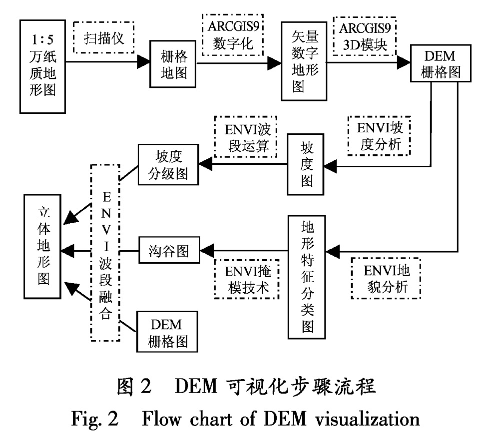
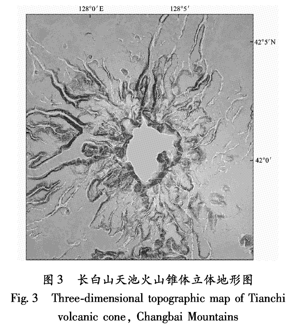
3.1 更新世喷发物形貌与高程分布特征
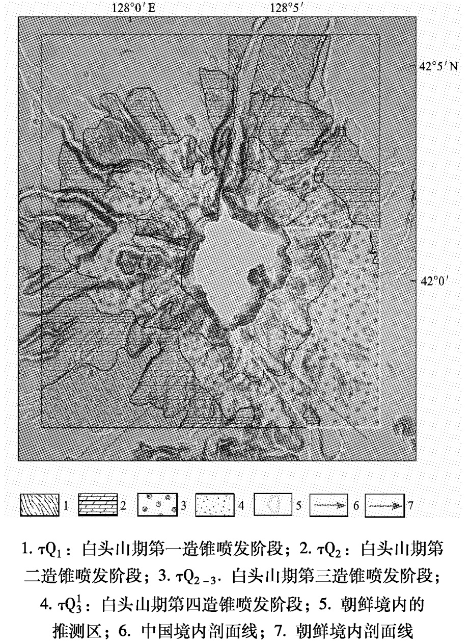
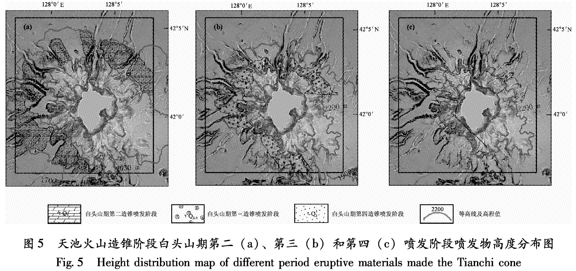
将长白山天池火山第四纪喷发岩性分布图(金伯禄,张希友,1994)叠加到立体地形图上,可以看出,各期喷发物分布范围与地形符合较好(图4)。叠加等高线后,发现白头山期四期造锥喷发阶段产物在高程上有明显的叠加层次性,其中,白头山期第一喷发阶段喷发物范围高度处于1 700 m之下; 白头山期第二喷发阶段喷发物范围高度大都处于1 700~2 050 m之间(图5a); 白头山期第三喷发阶段喷发物范围高度处于1 900~2 200 m之间(图5b); 白头山期第四喷发阶段喷
1.τQ1:白头山期第一造锥喷发阶段; 2.τQ2:白头山期第
二造锥喷发阶段; 3.τQ2-3.白头山期第三造锥喷发阶段;
4.τQ13:白头山期第四造锥喷发阶段; 5.朝鲜境内的
推测区; 6.中国境内剖面线; 7.朝鲜境内剖面线
图4 天池火山四期造锥阶段喷发物空间分布范围
Fig.4 The spatial distribution map of eruptive materials in Tianchi cone
发物范围高度处于2 200~2 600 m之间(
图5c)。
长白山天池火山更新世时期主要处于造锥阶段,大体分为4个阶段(金伯禄,张希友,1994)。由图4可以看出,位于中国境内的四期造锥喷发阶段产物分布范围存在清晰的层次性。白头山期第一造锥喷发阶段产物在最底层,距离火口沿最远8.6 km,也最为平缓,平均坡度12°(指未超出长白山天池火山第四纪喷发岩性分布图(金伯禄,张希友,1994)的最远距离,以下皆同); 白头山期第二造锥喷发阶段产物距离火口沿最远达7.4 km,基本是由一系列的垄组成,而垄的边界恰恰就是与第一造锥阶段的分界线,其平均坡度14°; 白头山期第三造锥喷发阶段产物距离火口沿最远达5.2 km,平均坡度18°,其与第二造锥阶段的区别不如前者明显,在北坡才有较明显的垄出现,可作为分界线; 白头山期第四造锥喷发阶段产物为最新喷发,其范围位于锥体最上部,由一系列紧靠火口的垄构成,平均坡度25°,距离火口沿最远达2.4 km。从距离、坡度分析来看,这四期喷发物喷发年代越早,其分布范围就越广、坡度越缓。
图5 天池火山造锥阶段白头山期第二(a)、第三(b)和第四(c)喷发阶段喷发物高度分布图
Fig.5 Height distribution map of different period eruptive materials made the Tianchi cone
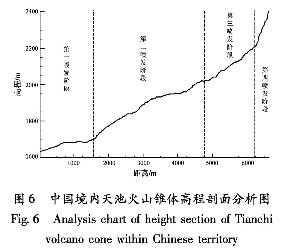
图6为中国境内天池火山锥体高程剖面分析结果图,剖面的高程位于1 630~2 400 m之间,穿越了白头山期不同喷发期次的分界线。可以看出,白头山期第一喷发阶段与第二喷发阶段之间有明显地势起伏的区别; 第二喷发阶段与第三喷发阶段之间地势起伏缓和,但第二喷发阶段剖面线凸起、第三喷发阶段剖面线凹陷,则后者坡度要比前者陡; 第三喷发阶段与第四喷发阶段之间也有明显地势起伏的区别。由此可见,各个喷发期次在地势起伏上有较大区别。朝鲜境内的情况亦是如此。图7描述了位于朝鲜境内的高程范围为1 889~2 580 m的剖面线,在高程2 166 m处有突变,可以作为两期喷发物的分界线。由此可见,地势起伏随着不同喷发阶段有较明显的变化,那么地势起伏的边界线就可以推测作为四个造锥阶
图6 中国境内天池火山锥体高程剖面分析图
Fig.6 Analysis chart of height section of Tianchi volcano cone within Chinese territory
图7 朝鲜境内天池火山锥体高程剖面分析图
Fig.7 Analysis chart of height section of Tianchi volcano cone within D.P.R Korean territory
段喷发物范围的分界线。
根据以上造锥喷发物的地形地貌特征,我们可以推测朝鲜境内的造锥喷发物分布范围。首先朝鲜境内的第四喷发阶段产物也是由一系列的陇组成,都在2 200~2 600 m之间,平均坡度17.5°; 第三喷发阶段产物则是比较平缓,平均坡度9.5°,高度位于1 900~2 300 m之间; 由于图幅面积所限,朝鲜境内的第二喷发阶段范围只有一点,平均坡度为7°。朝鲜境内的各个喷发阶段喷发物分布范围之所以较中国境内的大,主要是因为天地火山东南坡的平均坡度比其它坡更小。
3.2 全新世喷发物在地形地貌上的特征
3.2.1 气象站期碱流质碎成熔岩
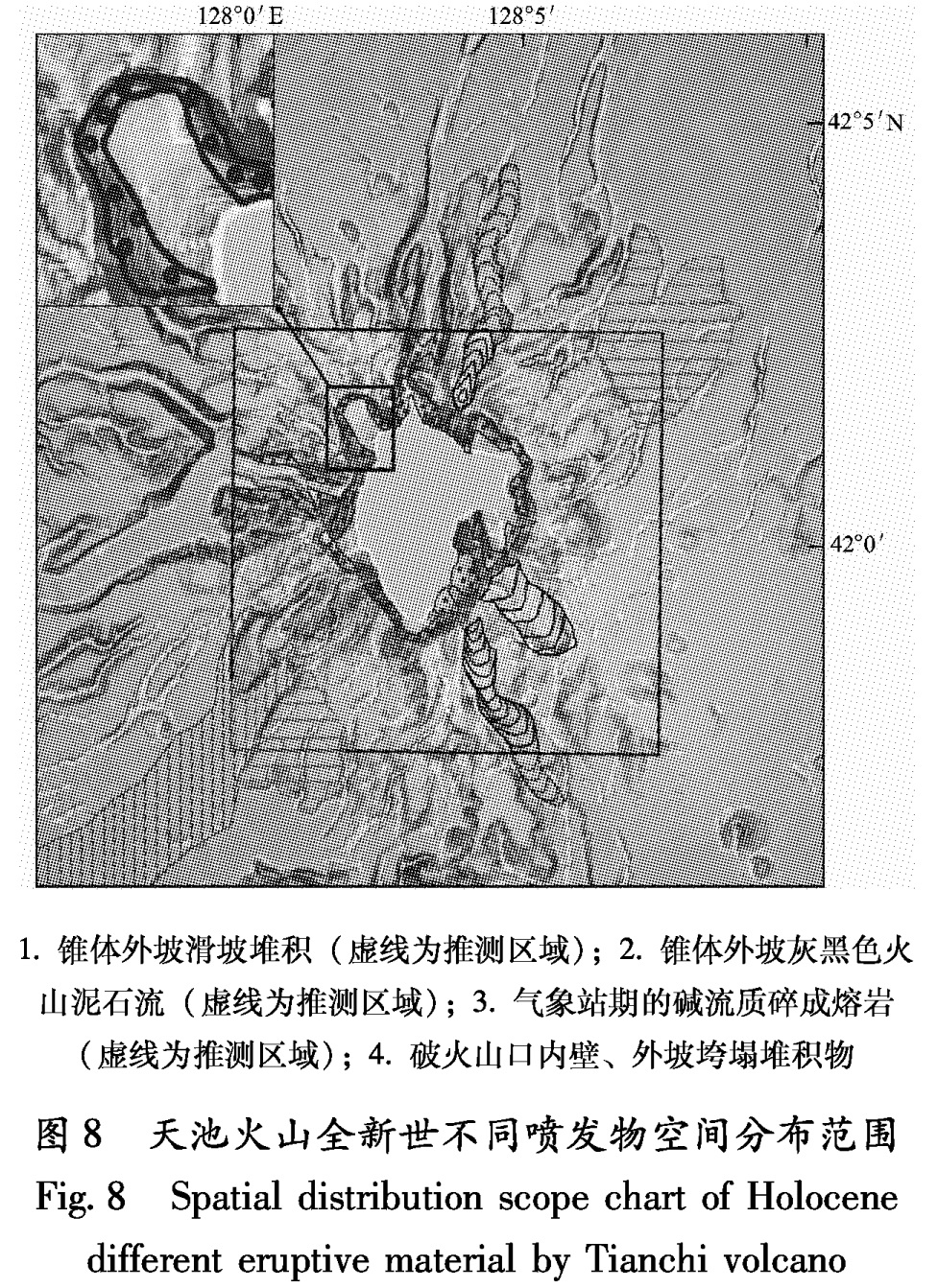
主要分布于天池气象站附近的北部山脊和朝鲜境内的东南部山脊上(图8),岩性为碱流岩质火山碎屑岩。按其成因可分为下部块灰流和上部熔岩状火山碎屑流堆积,厚度大于14 m。尹功明等(1999)的研究结果表明,气象站期的碱流质岩石的年龄为距今4 000 a左右。从图3和图8中可以看出,气象站期的碱流质碎成熔岩的地貌特征十分明显,沿着流动方向呈舌状分布,空间上局限在一条条狭长的垅的范围内,由此我们可以较为准确地推测出其全部范围。如图8所示,方框中的实线部分为野外实测的气象站期的碱流质碎成熔岩分布范围,方框之外的虚线部分则代表了推测的范围,黑框内喷发物分布范围源自天池火山锥体顶部火山结构与灾害分布图(魏海泉等,2004)。
1.锥体外坡滑坡堆积(虚线为推测区域); 2.锥体外坡灰黑色火
山泥石流(虚线为推测区域); 3.气象站期的碱流质碎成熔岩
(虚线为推测区域); 4.破火山口内壁、外坡垮塌堆积物
图8 天池火山全新世不同喷发物空间分布范围
Fig.8 Spatial distribution scope chart of Holocene different eruptive material by Tianchi volcano
3.2.2 锥体附近的滑坡堆积
天池火山锥体附近全新世的滑坡堆积主要分布于火山口内壁和火山口外坡(图8)。其中,火山口内壁和峡谷内壁的垮塌堆积物平均坡度为33.7°,大都在坡度陡的地方; 锥体外坡滑坡堆积主要分布在天池火山口的东北部和东南部地区(图8),相对于火口内壁的垮塌堆积物来说,锥体外坡滑坡堆积物坡度较缓,平均坡度8°,一般都是位于垄的上面,具有明显的地貌特征,据此我们可以在图上推测出更广的范围。
3.2.3 全新世泥石流
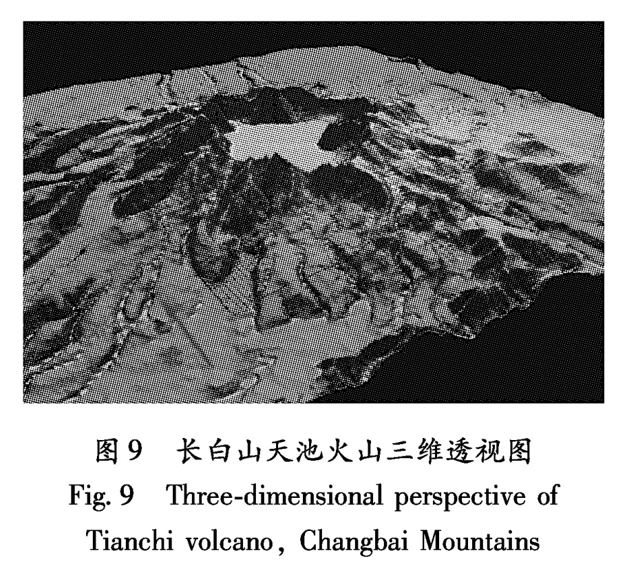
火山泥石流是天池火山重要的灾害类型之一,它包括由火山喷发物与水体混合(雨水、雪水及冰的融化)而形成的大体积快速流动的高密度流体及松散火山碎屑物被雨水冲刷、多次搬运的火山泥石流。火山泥石流灾害主要限于河谷低洼地带,快速大体积淤积的火山泥石流堆积物会使河床改道,堤坝淤积和破坏,造成一系列灾难性后果(杨清福等,2003)。图8中的全新世不同期泥石流的分布范围有主要位于火山口内壁和大峡谷内的各期泥石流,其平均坡度为16°; 有位于火口西南方向的锥体外坡灰黑色火山泥石流,其平均坡度为5°。位于火山口内壁和大峡谷内的泥石流相对来说范围小,都是在坡度比较陡的小沟谷内; 位于锥体外坡的泥石流则范围较大,且坡度也比较缓。图9为利用DEM做出的三维透视图,由图中可以看出锥体外坡的泥石流流向,结合等高线走向,可以推测锥体外坡灰黑色火山泥石流的范围。
图9 长白山天池火山三维透视图
Fig.9 Three-dimensional perspective of Tianchi volcano, Changbai Mountains