1.1 实验数据
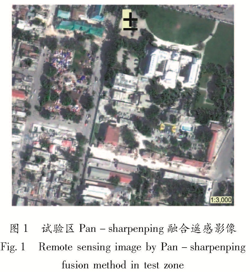
震后遥感数据为2010年1月16日Geoeye-1卫星获取的高分辨率卫星遥感影像,全色波段空间分辨率为0.5 m,多光谱波段空间分辨率为2 m(蓝、绿、红、近红外)。近红外波段参与分类,能够容易地分辨集中的植被和阴影。实验中选择典型建筑物倒损区——海地首府太子港总统府附近的遥感影像,实验区图像大小为796×723个像元,共575 508个像元。在ENVI软件中采用Pan-sharpenping数据融合方法,将全色波段和多光谱波段进行融合,生成0.5 m的Pan-sharpenping融合影像,如图1所示。
图1 试验区Pan-sharpenping融合遥感影像
Fig.1 Remote sensing image by Pan-sharpenping fusion method in test zone
1.2 实验步骤
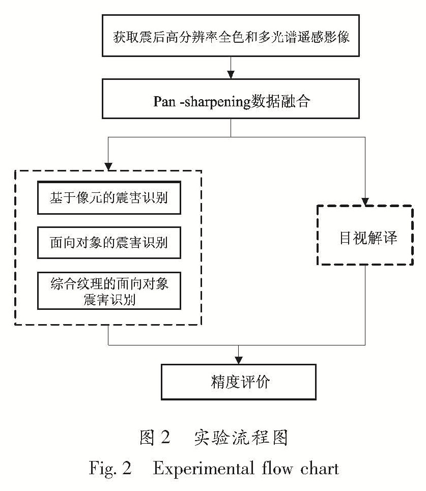
实验分为3个步骤:第一是目视解译; 第二是遥感分类(基于像元的方法、面向对象的方法和综合地统计学纹理的面向对象方法); 第三是精度评价。实验流程如图2所示。
1.2.1 目视解译
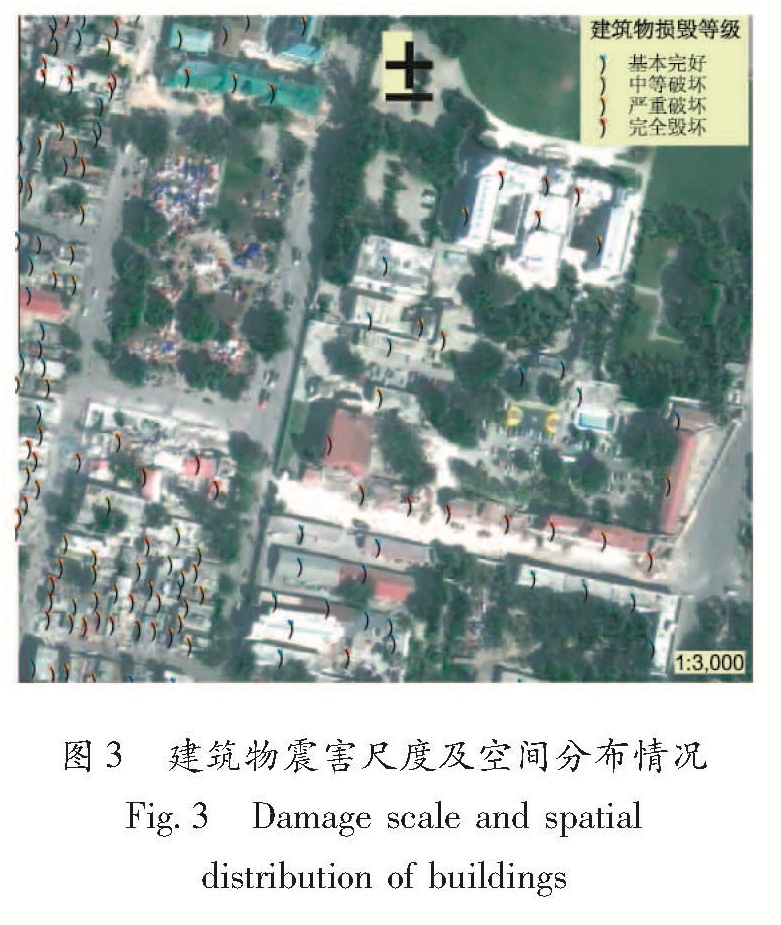
参照欧洲地震烈度表(EMS-98),建筑物损毁等级分为四级:基本完好(D1和D2)、中等破坏(D3)、严重破坏(D4)和完全毁坏(D5)。由于缺少地面真实参考数据,目视解译对参考了欧盟联合研究中心(Joint Research Centre,简称JRC)的解译结果,以及GoogleEarth震前的影像,对试验区的单体建筑物进行逐个目视解译,单体建筑物震害解译结果如图3所示。
图2 实验流程图
Fig.2 Experimental flow chart
图3 建筑物震害尺度及空间分布情况
Fig.3 Damage scale and spatial distribution of buildings
从
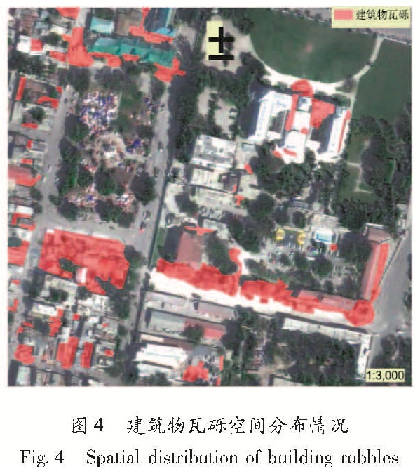
图3的单体建筑物震害评估的结果中,可以发现严重破坏和完全破坏的建筑物周围均有建筑物瓦砾,从而证明了瓦砾是建筑物倒损的明显震害特征之一。因此,笔者正是通过对建筑物瓦砾的自动识别来检测建筑物震害的空间分布情况。由于地震灾害的现场信息具有时间敏感性,在没有现场调查灾情数据的情况下,笔者采用目视解译作为“真值”对自动分类的结果进行精度评价。为此,对实验数据进行人工数字化建筑物瓦砾,其空间分布情况如
图4所示。
图4 建筑物瓦砾空间分布情况
Fig.4 Spatial distribution of building rubbles
1.2.2 面向对象震害识别
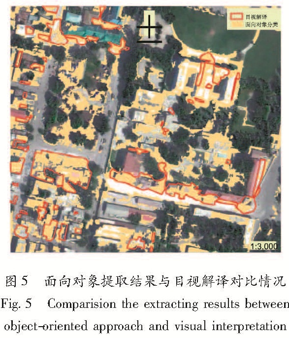
利用面向对象分类软件eCognition进行基于面向对象的瓦砾信息提取,包括3个步骤; 首先分割遥感影像。经过反复实验,采用的分割尺度为49,参与分割的波段包括蓝、绿、红和近红外,并且每个波段的权重均设为1; 然后选择分类样本,根据实验区地物实际分布情况,选择了10种分类样本:黑色屋顶、灰色屋顶、绿色屋顶、红色屋顶、白色屋顶、草地、树冠、阴影、道路和建筑物瓦砾; 最后进行监督分类。监督分类采用最邻近分类算法,分类指标为样本的均值和方差。基于面向对象技术自动提取的瓦砾与目视解译结果的对比如图5所示。
在图5中,面向对象的方法能够正确识别大部分建筑物瓦砾,特别是建筑物成片倒塌区域。同时,分类结果仍然存在漏分和错分现象。漏分主要是一些面积较小的瓦砾; 自动提取的瓦砾明显多于目视解译的结果,这些错分主要发生在临时转移安置点(如帐篷)散布的区域、表面较为粗糙且不均匀的建筑物屋顶、低矮建筑物密集区、一些微小地物(如车辆)和不同地物交界的边缘(如树冠与道路、阴影与道路)。
图5 面向对象提取结果与目视解译对比情况
Fig.5 Comparision the extracting results between object-oriented approach and visual interpretation
1.2.3 基于像元的震害识别
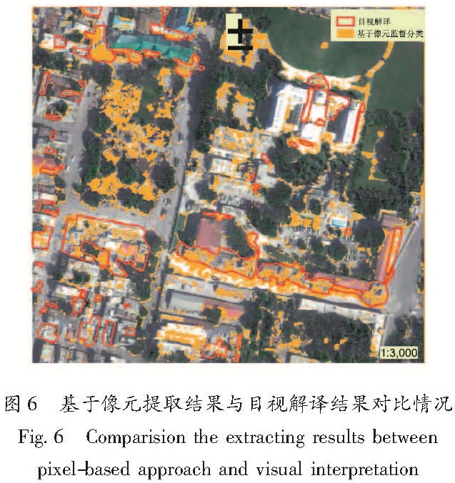
为了与面向对象方法进行比较,实验中利用ERDAS软件采用基于像元的最大似然分类方法提取建筑物瓦砾。其分类的样本与面向对象分类方法中采用相同的样本。基于像元提取的瓦砾与目视解译结果的对比如图6所示。
图6 基于像元提取结果与目视解译结果对比情况
Fig.6 Comparision the extracting results between pixel-based approach and visual interpretation
从
图6可以看出,自动提取的建筑物瓦砾散布在整个实验区,分类结果明显多于目视解译,但相对于前文所用的基于面向对象分类方法,错分现象有所减小,同样还发现临时转移安置点散布的区域被错分为瓦砾,地物交界的边缘部分也容易被错分,漏分现象更为明显,建筑物倒塌后大块瓦砾被漏分。
1.2.4 综合纹理的面向对象震害识别
地质统计学被广泛应用于遥感影像纹理的提取,并且优于基于傅立叶纹理提取方法(Maillard,2003)。综合纹理的面向对象震害识别方法包括二个步骤:提取地统计学纹理特征和多尺度面向对象分类。
第一步,提取地质统计学纹理特征。标准半方差函数对图像中的极端DN值具有敏感性,因此本文采用Lark(1996)提出的均方根对差函数(Mean Square Root Pair Difference Function,简称SRPD)代替标准半方差函数,计算公式为
SRPD(h)=1/(Nh)∑[ABS(DNi-DNi+h)]1/2.(1)
式中,SRPD是总体均半方差的无偏估计; N是像元对数目; DNi和DNi+h代表相距h的两个像元值。实验中对全色波段提取SRPD纹理,并采用了经验半方差图确定纹理提取时的尺度参数,其中窗口大小为3×3个像元,窗口内步长距离为1个像元、步长方向为全方向。
第二步,多尺度分割的面向对象分类。经过反复实验发现应用SRPD纹理波段替换Pan-sharpenping融合影像中的蓝波段分类效果最好,所以采用纹理、绿、红和近红外这四个波段参与分类。从上述两个实验中发现,不同地物类型交界的边缘部分容易被错分。为了使尽量少的地物类别参与分类,实验中先采用小尺度分割实验区影像,从而排除植被等微小地物的影响。经过反复实验,采用的第一个分割尺度为28。在实验中,采用保守取阈值的原则,建立了2个知识规则,从而排除植被和阴影:(1)NDVI值不小于0.03为透水层(植被),与植被邻接度大于0.5的也归为植被;(2)近红外波段值不大于140,亮度值不大于145,同时与阴影邻接度大于0.5的也划为阴影。
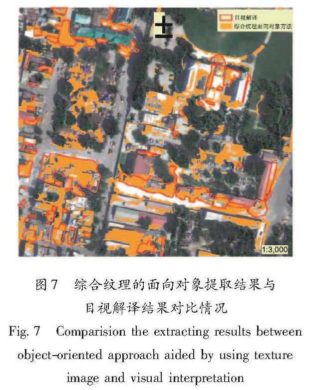
经过上述处理,实验区剩余4种未分类的地物类型:建筑物、道路等空旷用地、瓦砾以及少量阴影。因为大尺度分割有利于建筑物等大对象的提取,第二次分割对象时采用的分割尺度为49。除阴影样本外,选择了与上述2种方法中相同的7类分类样本,并采用最邻近分类算法进行监督分类,参与分类的波段包括纹理、绿、红和近红外,分类指标为样本的均值和方差。经过自动提取的瓦砾和目视解译结果的对比情况如图7所示。
图7 综合纹理的面向对象提取结果与目视解译结果对比情况
Fig.7 Comparision the extracting results between object-oriented approach aided by using texture image and visual interpretation
在
图7中,大面积的建筑物倒塌区域能够被准确识别,部分小面积的瓦砾存在漏分现象。与上述2种实验方法进行比较,发现瓦砾错分现象明显减少。
1.3 精度评价
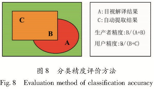
以目视解译的结果作为地面真值,对3种瓦砾自动识别方法进行精度评价。通过分类总体精度、Kappa系数,以及瓦砾的生产者精度和用户精度这四个指标来评价分类结果。精度评价方法如图8所示,精度评价结果如表1所示,3种方法的精度比较统计图如图9所示。
图8 分类精度评价方法
Fig.8 Evaluation method of classification accuracy
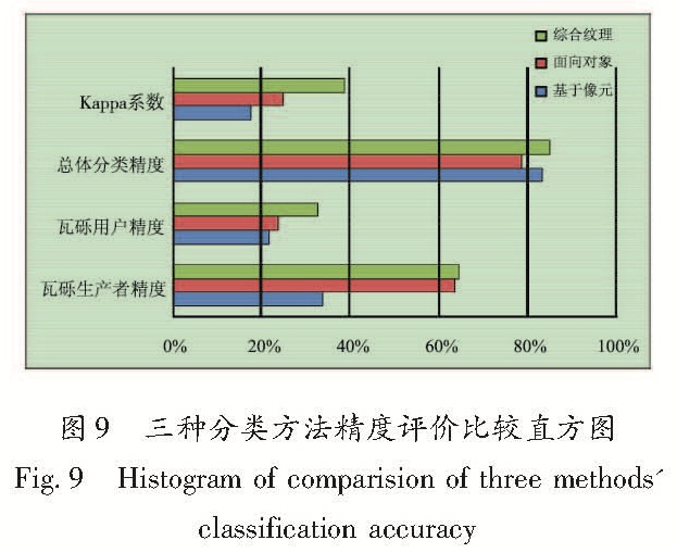
图9 三种分类方法精度评价比较直方图
Fig.9 Histogram of comparision of three methods'classification accuracy
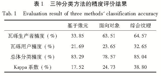
表1 三种分类方法的精度评价结果
Tab.1 Evaluation result of three methods' classification accuracy
从表1和图9 可以看出,3种方法的总体分类精度相差并不明显,但是基于像元的分类方法的总体分类精度高于单纯的面向对象方法,并不是预想的面向对象方法的总体精度一定高于基于像元的分类方法。综合纹理的面向对象方法的4个精度评价指标均高于另外2种方法,其中总体Kappa系数明显提高。
就瓦砾的生产者精度而言,两种面向对象分类方法均明显高于基于像元的分类方法,并且大于60%,说明采用面向对象的分类方法超过一半的建筑物瓦砾可以被正确识别; 而基于像元的监督分类方法的生产者精度只有33.85%,说明有超过一半的瓦砾被漏分。
而3种方法的用户精度相差不大,并且均低于33%,说明这3种方法将非瓦砾区域错误识别为瓦砾的区域大致相同,通过分析3种方法分类结果,错分主要发生在:(1)临时转移安置点散布的区域(如帐篷);(2)表面较为粗糙的完好建筑物屋顶以及低矮建筑物物密集区;(3)不同地物交界的边缘区域(如树冠与道路、阴影与道路等);(4)一些微小地物(如车辆)。
当加入纹理信息后,Kappa系数明显提高14个百分点,用户精度也明显提高9个百分点,而生产者精度只提高了1个百分点,说明当加入纹理信息后,明显增加了建筑物瓦砾识别的准确性,然而漏分现象的改善并不明显。