利用多期高精度GPS监测资料,确定区域构造运动及变形的水平运动图像,分析研究区域构造运动与变形的状态和演化过程,获取应变场信息,从理论上描述区域内构造活动的演化过程和发展趋势。在此基础上进行合理的地球动力学解释,使之应用于地震危险性分析及中长期强地震预测是切实可行的。
2.1 南天山地区应变场分析
2.1.1 主应变
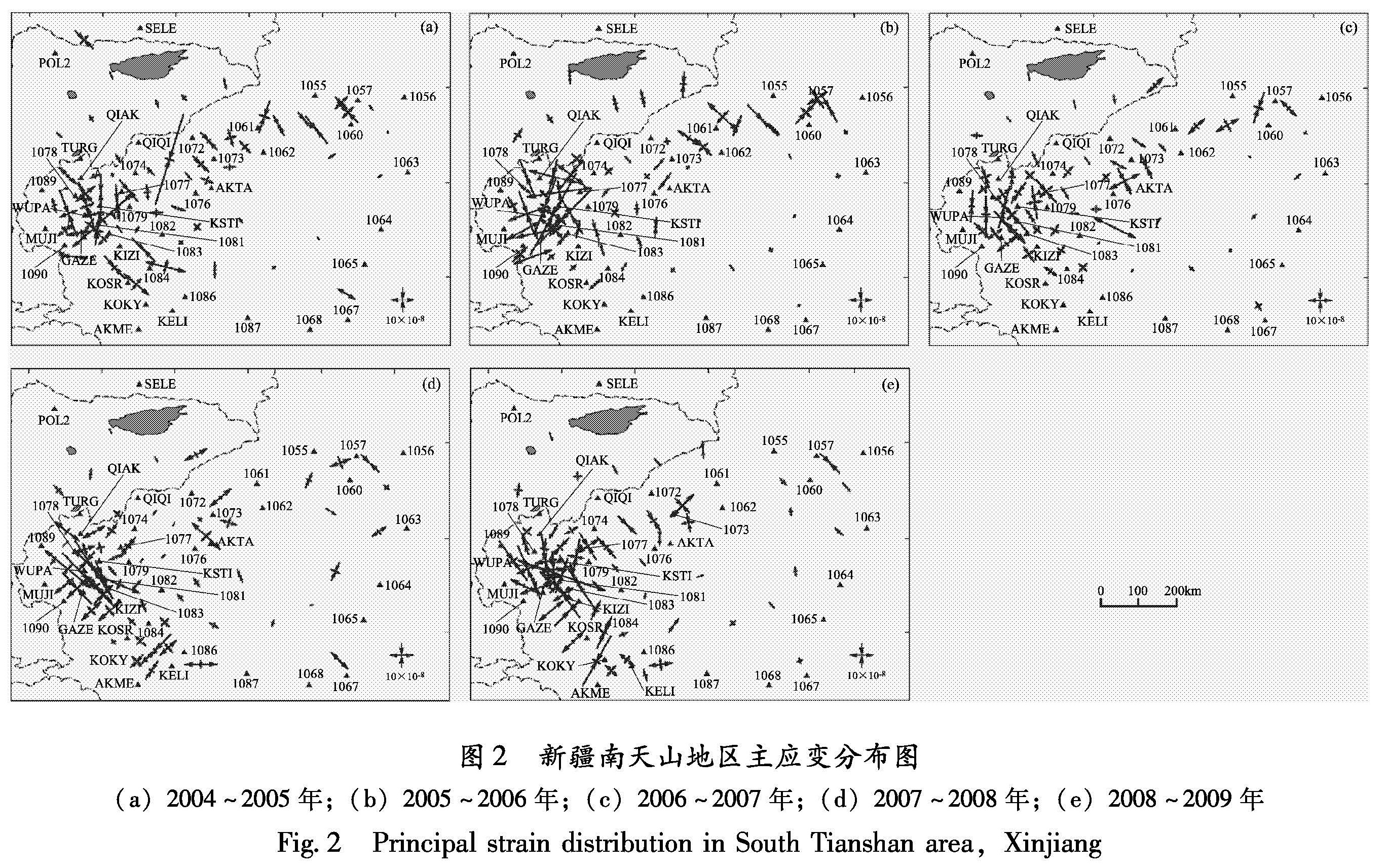
通过对2004~2009年的主压应变分布计算(图2),结果表明:南天山地区最大主压应变集中分布在南天山西侧地区,基本上以近南北向主压应变为主。南天山地区构造运动最为活跃,是受印度板块向北碰撞欧亚板块以及帕米尔高原与塔里木块体持续挤压楔入的强烈影响而形成。
2004~2005年主应变分布表明(图2a),在研究区域内最大主压应变集中分布在南天山西部,以北北西向主压应变为主,方向沿塔拉斯—费尔干纳断裂走向,与天山山脉走向基本正交。主压应变量值较大的地区集中分布在天山褶皱带上,其中以南天山与西昆仑北缘及帕米尔高原交界地区以及乌什、阿合奇地区较为明显。塔里木块体整体虽然南北向以主压应变为主、东西向以主张应变为主,但整体应变较小,说明塔里木盆地作为一个刚性块体在受印度板块推挤和青藏高原隆起时向北推挤的过程中,其内部速度基本一致,内部构造变形很小,并且通过多年的地震监测发现该块体确实极少发生地震,整个块体较完整,内部没有过多的破裂。从应变分布图2a中可以看出最大主压应变在量值分布上基本上沿天山、帕米尔、西昆仑一侧,在喀什、乌恰、乌帕尔等地区以及乌什以西、阿合奇、契恰尔等地区较为集中,这可能与2005年乌什6.3级地震有关。
2005~2006年主应变分布(图2b),南天山地区应变场以压应变为主,方向近北北西。在阿克苏地区主应变方向稍有不同,接近北北东方向,应变值不大。阿克苏以东地区主应变接近南北方向,集中在库车、拜城地区。塔里木块体主应变变化不大,进一步说明了塔里木块体在受印度板块推挤和青藏高原隆起时的向北西推挤的过程,所体现出的刚性块体的特征。
2006~2007年研究区域的应力场背景决定了南天山地区以压应变为主,最大主压应变方向接近南北(图2c)。通过测量发现区域内的主压应变变化不大,体现出一种平稳趋缓的态势。但在不同地区主应变方向有所不同:以喀什为中心100 km的区域内主压应变方向接近正南北,其南部地区为北北西,量值接近15×10-8~20×10-8; 阿克苏地区主压应变也基本为北北西向,量值很小。阿克苏以东地区主应变接近南北方向,集中分布在库车拜城地区。塔里木地区的主压应变与以往相同,主压应变变化极小,作为刚性块体的塔里木在收推挤变形过程中仍旧保持了良好的整体特性。
2007~2008年的应力变化情况(图2d)可以看出,GPS解算出的主应变在喀什、乌恰、木吉等地北西向张应变较强,其方向与南天山断裂西端垂直,这与2008年3月于田7.3级地震震源机制解结果是一致的,震源机制解结果显示该地震是在北西向拉张作用下产生的破裂过程。在主应变较集中的乌恰以西地区于2008年10月5日发生
了6.8级地震,该地震震源机制解反映出走滑错动的特点(高国英等,2010),这也与GPS观测结果很吻合,而在阿克陶、英吉沙等地则是北东方向的压应变,其方向与帕米尔弧形断裂相垂直,其它区域主压应变或张应变则较分散。
2008~2009年观测计算结果与2008年的相比,从南天山主压应变率分布图(图2e)可以看出,在整个关注的区域内,仍旧以印度板块向北推挤欧亚大陆造成近南北向挤压为主,与近10年以来的长期GPS观测主压应变结果对照,总体上没有改变。以喀什为中心,主压应变方向近似北北西,和田、皮山以西至库地、克里阳等地区主压应变方向近似北北西,最大值亦分布在上述两个区域。根据近几年的地震震源机制解可知,最大主压应力P轴方位基本与新疆主要构造的走向垂直,P轴方位以北北西向为主,但也存在北北东方向的压应力(高国英等,2010)。主应变最大值集中于以喀什为圆心,向西南方向200 km至霍什拉甫、向北西方向100 km至乌恰,东到伽师的范围。
从2005~2009年不同时段的主压应变分布位置来看,喀什、乌恰一带主应变较为集中,集中区主应变方向为北北西,而阿克苏、和田一带为
图2 新疆南天山地区主应变分布图
(a)2004~2005年;(b)2005~2006年;(c)2006~2007年;(d)2007~2008年;(e)2008~2009年
Fig.2 Principal strain distribution in South Tianshan area,Xinjiang
北北东,表现为受印度板块向北推挤而形成的近南北向压性应力场。由于这一区域构造应力场比较复杂,受多个构造单元影响,因此某个区域具体的应力应变状态可能会受特定块体(如青藏高原、帕米尔高原、塔里木盆地)的影响而变化。
2.1.2 剪应变
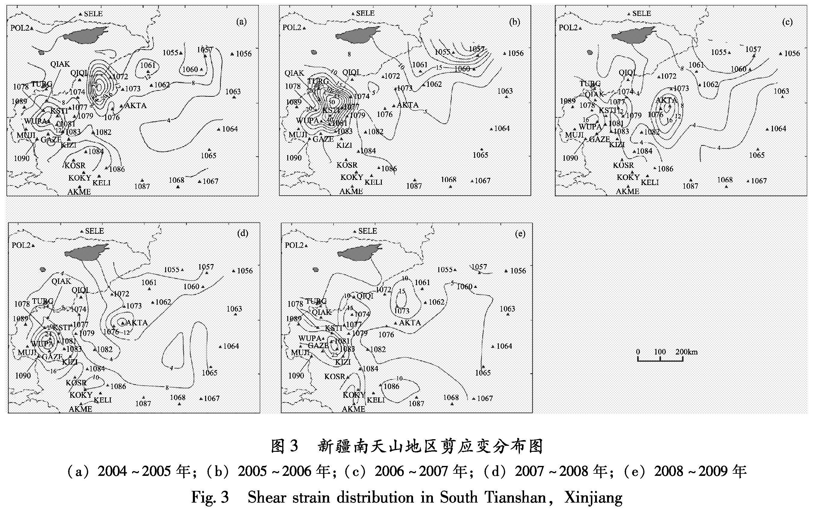
图3给出了2004~2009年南天山地区最大剪应变率分布结果,从图3可以看出,最大剪应变的年度变化在地域分布上虽然有差异,但基本上仍旧以南天山推覆带、塔里木盆地西北与帕米尔弧形断裂所围区域为中心而集中存在。
2004~2005年剪应变分布(图3a)表明,2005年2月15日在乌什以北地区发生6.3级地震后,该地区的最大剪应变值从乌什以北地区移到了乌什西、阿合奇(I072)、契恰尔(QIQI)以及巴楚(I076)、夏胡尔(AKTA)、克拉克钦(I075)以北地区之间,量级大约在40×10-8。乌什6.3级地震结束后,其能量依旧没有释放完毕,在另外一个新的邻近区域重新聚集,同时在喀什(KSHI)、乌恰(I078)以及乌帕尔(WUPA)、阿克陶(I081)地区也出现了新的高值区,与6.3级地震震源机制解的结果一致。
2005~2006年剪应变分布情况(图3b)总体来看,以I077(苏滚)为中心,与周边I079(伽师)、I074(哈拉峻)、I081(阿克陶)、KSHI(喀什)、I078(乌恰)、QIAK(恰克马克)所围成的半径100 km的区域内,是最大剪应变集中分布区域,从图2b上可以看出,该区域主压应变方向为北北西向。 从南天山地区2006~2007年剪应变分布图(图3c)上看,巴楚(I076)、夏胡尔(AKTA)、I073(柯坪)等地所围的区域内,是最大剪应变集中分布区域。与以往的结果相比,乌什、阿克苏地区与喀什西南地区也有较高的剪应变量值存在。但与以往比较量值相差不大,反映了整个南天山地区的应变能量呈现出一种平稳态势。
从2007~2008年南天山地区的剪应变分布情况(图3d)可以看出,在喀什、木吉、阿克陶、布伦口、克孜勒等地围成的区域内有一个较强的剪应变高值区,其中心最大值约为30×10-8,剪切方向应为北偏东,该项GPS野外观测工作在2008年8月底结束,10月5日在其西部剪应变高值区边缘发生了6.8级地震,这个高剪应变值的出现,和该次6.8级地震密不可分,可能是此次地震的前兆异常反应,这与2003年巴楚—伽师6.8级地震、2005年乌什6.2级地震前的剪应变出现高值情况是一致的。
图3 新疆南天山地区剪应变分布图
(a)2004~2005年;(b)2005~2006年;(c)2006~2007年;(d)2007~2008年;(e)2008~2009年
Fig.3 Shear strain distribution in South Tianshan,Xinjiang
从2008~2009年最大剪应变分布图(图3e)可以看出,以喀什西南为主,与柯克雅库地所围成的两个新的最大值区域,剪应变大约为50×10-8和30×10-8,量级相对较大,说明能量在此处积累。
分析2005~2009年不同时段的最大剪应变情况,最大剪应变主要集中在乌恰、喀什等一带区域,该区域正是天山南缘逆冲断裂最发育的部位,较强的剪切变形与天山南缘的变形活动趋势相对应,近期地震活动也主要集中在该区域。帕米尔弧形断裂与西昆仑北缘断裂及南天山推覆带、塔里木盆地所构成的地区剪应变量值最为突出(10-8/a~10-7/a),这与杨国华等(2002)、江在森等(2003)的研究结果基本一致。
从历史地震发震记录来看(图1),南天山地区大部分中强地震集中发生在该地区,从而在一定程度上表明GPS结果得出的剪应变量值的高度集中说明今后该区域可能发生强震。2003年2月巴楚—伽师6.8级和2008年10月乌恰6.8级地震的发生进一步说明了剪应变高度集中的地区可能与强震存在密切的关系(李杰等,2004)。
受板块运动的作用,南天山监测区域的块体运动挤压,使得帕米尔—西昆仑北缘断裂带与南天山山前地震构造带作为应变能量积累地区而形成了目前的强震危险区。江在森等(2003)指出1997年以来,南天山地区地震发生在剪应变(最大剪应变、第一剪应变、第二剪应变)的高值区或边缘区。从图3可以清楚地看出,在高剪应变集中区或其边缘地带确实存在着发生中强地震的可能。
2.2 利用基线变化率分析南天山地区地壳运动特征
应用GPS基线能够较好地反映点位速度场、区域应变场的变化。很多学者就GPS基线长度的变化与地震孕育的相关性进行了研究。闫伟等(2007)根据中国地壳观测网络GPS基准站连续观测资料研究昆仑山地震前后发生的地震与GPS基线长度及方向的变化特征。
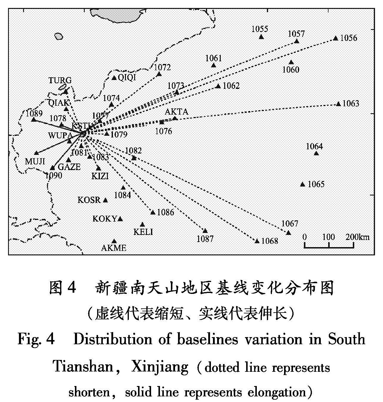
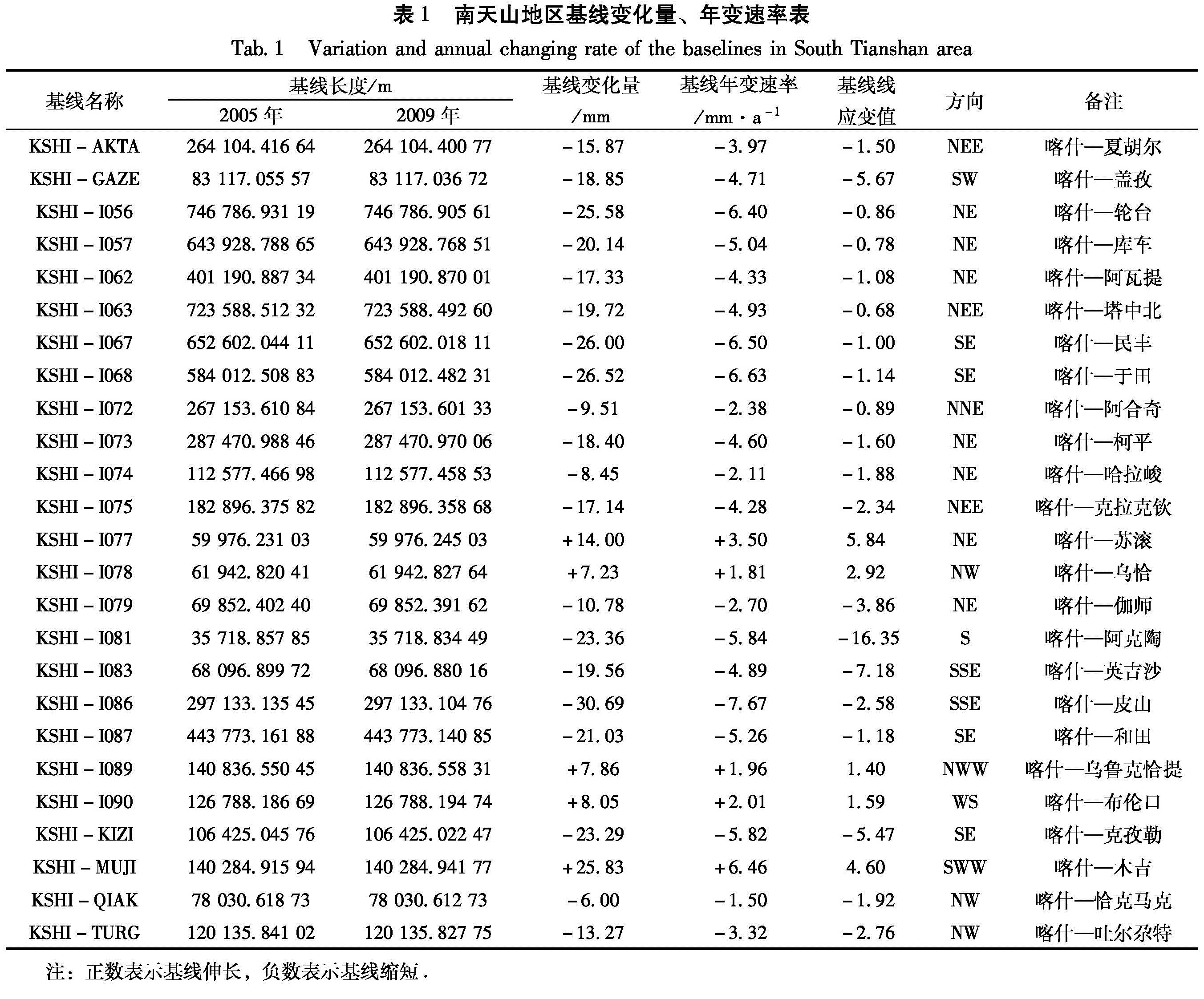
笔者利用2005~2009年共5期的GPS数据,计算出各条基线(以喀什为中心基准,各GPS点相对喀什测站的基线长度)的变化量、变化率并且列出了基线的方向。5年尺度基线的变化速率能较好地反映地壳最近的活动,是分析判别近期有无形变异常的基础。从伽师及邻近地区基线变化量(变化速率)可以看出(表1),该区域大部分基线都在缩短,变化最大的基线为喀什—皮山,变化速率为-7.67 mm/a,说明在该区域东南方向压缩最强烈。另外,喀什—苏滚、喀什—乌恰、喀什—乌鲁克恰提、喀什—布伦口、喀什—木吉这5条基线变化为正值(伸长),变化最大的基线为喀什—木吉,变化速率为+6.46 mm/a,说明在该区域西南、以及西部方向上呈现拉张趋势。
从新疆南天山地区基线变化整体统计分析(图4),以喀什沿经线南北向为界,可以看出喀什东部区域基本为压缩区,其西部区域基本为拉张区,其东部的基线缩短平均速率(4.84 mm/a)大于西部基线伸长的平均速率(3.06 mm/a)。以喀什沿纬线东西向为界,其南部区域基线变化平均速率(5.58 mm/a)明显高于北部区域基线变化平均速率(3.52 mm/a),且伸长、压缩变化速率最大基线均在南部地区,这也表明喀什南部区域地壳运动相对活跃。
从基线线应变结果上看,位于喀什南部地区的阿克陶、英吉沙线应变值最大,分别为-16.35和-7.18,反映了块体推覆挤压背景下的南天山地区强烈的南北向压应力构造活动特征。在喀什东西两侧的基线变化则反映了南北向挤压趋势下运动块体向东西方向拉伸逃逸的趋势(如喀什至苏滚基线线应变为5.84,喀什至布伦口为1.59)。
图4 新疆南天山地区基线变化分布图
(虚线代表缩短、实线代表伸长)
Fig.4 Distribution of baselines variation in South Tianshan,Xinjiang(dotted line represents shorten,solid line represents elongation)
表1 南天山地区基线变化量、年变速率表
Tab.1 Variation and annual changing rate of the baselines in South Tianshan area
注:正数表示基线伸长,负数表示基线缩短.
研究表明中强地震的孕育是在地壳活动增强的基础上发展的,中强地震的孕育不是局部地段活动的结果,尤其是6级以上地震,应该是伴随大区域构造活动的加强,才有足够的能量供给积累区,从而孕育形成大震(吕桂林等,1997)。