实时动态地震定位方法的核心内容就是当地震发生以后,根据整个地震台网中台站触发的先后顺序,采用单台触发确定震中所在区域,双台触发确定震中轨迹所在空间位置,三台触发确定准确的震中经纬度坐标,以实现渐进式地震定位的目的,从而不断提高地震定位精度,以期解决地震预警中时效性与定位精度之间的矛盾。
举例来说,当1个有感地震发生以后,随着地震波在整个地震台网中的传播,利用有限的台站(一般选取3个台站)记录的P波到时信息,先将地震震中限定在一个非常有限的区域内,然后进一步缩小到一个有限的线段上,最终确定一个比较准确的地震震中经纬度坐标。随着获得的地震信息的不断增加,将地震定位结果进行实时不间断的修定,使定位精度逐步提高。在该方法中我们引入了Voronoi图进行强约束,不但可以控制地震快速定位的精度,而且可以使定位过程中的数据计算量、预警响应计算时间都减小,以便获得更长的预警时间,减小预警盲区。
2010年3月24日12时27分22.7秒在山东省莒南发生ML1.3地震,震中位置(35.248°N,118.836°E),山东地震台网中的JUN、TAT和JUX台先后记录到了该次地震,P波到达这3个台站的时间分别为24.38 s、28.14 s和28.19 s。本文以该次地震做为实例,详细解释动态地震定位的技术思路和方法。
1.1 利用Voronoi图确定地震发生的区域
Voronoi图目前已广泛应用于图形学、机械工程、虚拟现实、地理信息系统、机器人、图像处理、CAD等领域,受到人们的广泛关注,也初步应用于地震速报(Satriano et al,2008)和应急管理中。在地震定位中的应用思路就是根据三角形增长算法的原理(姬安召,兰燕,2009)将测震台站两两相连形成Delaunay三角网,同时作连线的中垂线,中垂线相交形成若干个凸多边形,即Voronoi图(也称为泰森多边形)。
其基本思路是把整个地震台网中的每个地震台站都看作1个点,寻找每个点的有序目标三角形,而寻找有序目标三角形的常规方法是遍历所有的三角形,找到与该目标点相关的所有三角形。对该有序目标三角形的圆心按空间位置进行顺时针或逆时针排序,然后依次连接圆心就可生成该点的Voronoi图(即这个台站所对应的V单元)。而对于整个地震台网来说,需遍历所有点(地震台站),就可生成包含所有地震台站的整个地震台网的Voronoi图。图1给出了由山东省虚拟测震台网形成的Voronoi图。
图1 山东虚拟地震台网建立的Voronoi图
Fig.1 Voronoi diagram established by Shandong Virtual Seismic Network
当地震发生以后,整个地震台网中仅有1个地震台站最先记录到该次地震的地震波(最先到达的是P波),根据Voronoi图的性质,则可以确定地震震中必位于这个地震台站所生成的V单元区域内。
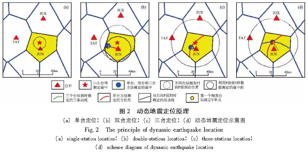
JUN台最先记录到山东省莒南ML1.3地震,则该地震震中一定位于JUN台所在的V单元内,也就是由5个顶点所围成的凸多边形内。由于确定该地震震中区域仅需要第1个台站的P波到时,则计算响应时间几乎为0,如图2a所示。
1.2 利用单个台站数据对震中进行粗略定位
在传统的地震定位方法中,最简便的定位方法就是利用单台方位角和单台震中距进行地震定位(田玥,陈晓非,2002)。由于单台方位角和震中距的计算误差比较大,所以在地震预警中,
图2 动态地震定位原理(a)单台定位;(b)双台定位;(c)三台定位;(d)动态地震定位示意图
Fig.2 The principle of dynamic earthquake location(a)single-station location;(b)double-stations location;(c)three-stations location; (d)scheme diagram of dynamic earthquake location
引入凸多边进行强约束,使震中距的误差尽可能减小,以便最大限度的减小定位误差。
在地震定位的实际计算中,我们将利用单台记录到的P波前3 s波形数据计算单台方位角和震中距,并对地震进行粗定位,其原理如图2b所示。在前面给出的地震实例中,其定位误差为16.17 km(指重新定位后震中位置与地震台网观测报告给出的震中位置之间的距离,不考虑震源深度的影响,下同)。
1.3 利用双曲线确定地震震中轨迹所在空间位置
在平面直角坐标系内,到两个定点的距离之差的绝对值为常数(小于这两个定点间的距离)的点的轨迹是双曲线方程。而2个地震台站的P波到时差也近似满足这种双曲线分布规律,符合这一规律的点的坐标(x,y)如式(1)所示,它表示的是震中轨迹:
(4x2)/(V2P(T2-T1)2)-(4y2)/(4c2-V2P(T2-T1)2)=1.(1)
式中,VP代表P波速度,T1和T2分别代表2个台站的P波到时,(x,y)代表震中轨迹,其原理如图3所示。
图3 双曲线定位原理
Fig.3 The principle of hyperbola location
随着地震波继续向震中区域以外快速传播,台网中将有第2个台站记录到地震波,基于双曲线原理,利用两个台站的P波到时差构建震中轨迹方程(Paul,2004),并使用双曲线方程的1个解代替单台地震定位中的震中距,结合单台测定的方位角信息,对单台地震粗定位结果进行适当修定,其原理如
图2c所示。使用该方法对莒南M
L1.3地震实例重新定位的结果显示,定位误差约为8.82 km。
1.4 利用多条双曲线确定地震震中经纬度
地震波随着时间继续向震中区域以外传播,当整个地震台网中有第3个台站记录到P波到时信息时,可以使用3个台站相互组合构造3条双曲线方程,通过3条双曲线方程的交点坐标就可以更加准确地确定地震震中位置,并对前面的地震定位结果进一步修定,原理如图2d所示。使用3条双曲线对前面的地震实例进行定位的最终误差约为1.48 km。
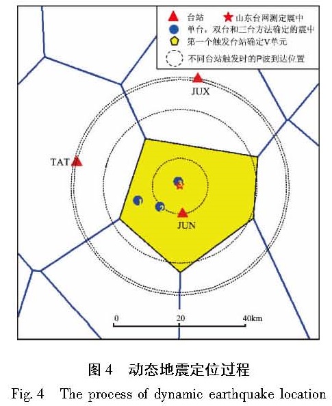
由以上实例可知,动态地震定位方法是使用最少的地震信息,以最小的计算响应时间,达到最大的预警时效。由于仅使用先记录到地震的前3个台站的P波到时信息,其时效性是显而易见的,而地震定位精度在不断的修定过程中也达到逐步缩小误差的目的。由些可见,动态地震定位方法是地震预警中比较实用的一种快速定位方法,其地震定位过程如图4所示。
图4 动态地震定位过程
Fig.4 The process of dynamic earthquake location