1.1 基础数据库特点
根据地震现场灾害损失评估(GB/T 18208.4— 2011)对基础数据的要求,HAZ-China地震灾害损失评估系统需要大量完备、准确的地震基础数据库做支撑,才能给出及时准确的信息以及评估结果,其基础数据库具有如下特点:
(1)海量、种类繁多的数据。破坏性地震发生后波及范围广、影响大,社会经济各个方面都会受地震影响,包括建筑、生命线、交通、水利、电力、滑坡、泥石流以及人类的正常生产生活等。
(2)涉及范围广。我国即将颁布的新一代《中国地震动参数区划图》显示,我国75%以上的城市都面临着严重的潜在地震灾害威胁。因此,我国地震形势严峻,并且潜在危险震源区范围广。虽然各个地区的危险性程度各不相同,但是危险性低的地区的基础数据不能空白。
1.2 基础数据库的类型
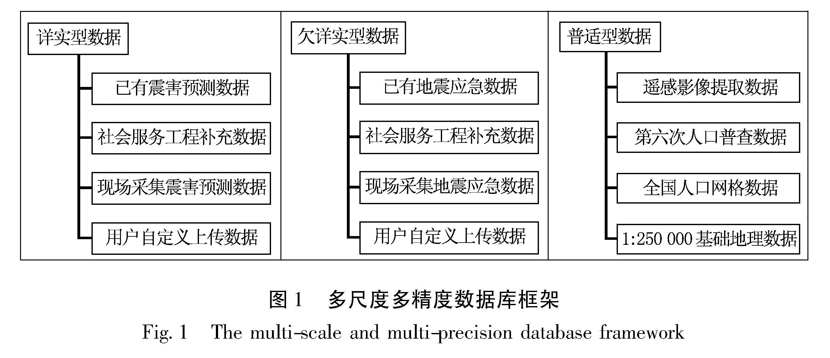
由上可见,利用传统的数据库建设思路建设全国范围的地震损失评估数据库是不可行的。因此,考虑到建立地震基础数据库的巨大工作量,本文提出综合各地区的地震发生频度、抗震能力、经济发展水平、人口分布等因素采用多种途径建立不同尺度、不同精度的地震灾害损失评估数据库,包括详实型数据、欠详实数据和普适型数据(图1)。
(1)详实型数据,主要针对某个城市或单元小区,按照规范要求首先搜集当地人口、经济、环境等基本信息,各类工程结构总体分布情况、当地建筑物的结构特点、结构类型和各类建筑物所占比例、各类生命线工程基本信息、场地分类与地震地质灾害。对重要建筑物进行逐栋调查,并进行地震易损性分析,对量大面广的建筑按结构类型分类在每种类型中抽取一定数量的样本,并进行地震易损性分析。
详实型数据通常是建立市县震害预测信息管理系统时,对基础数据进行详细调查。详实型数据主要依靠现场调查辅以统计资料等手段,数据精度高、数据库建设周期长、耗费人力物力多、数据更新困难。显然用这种数据精度来建设和维护更大范围内(比如省、包括农村地区的市县)的基础数据库工作量是巨大的,在经济成本上不可行(Chen et al.,2013)。
(2)欠详实数据,主要针对省一级的区域范围,按照统一数据格式以统计数据为主建立基础数据库。与详实型数据不同,欠详实型数据的建筑分为地市房屋总体统计表,区县房屋(分城区和农村)统计表,最详细一级只到乡镇,给出某个行政区范围内房屋结构类型比例、建筑年代、层数、面积等信息。由于欠详实数据最精细一级数据到乡镇,其实是假定乡镇内的房屋是平均分布的,但实际乡镇的建筑物分布情况不会平均分布。以上数据主要来源于人口普查数据和地方政府调查。国民经济数据也是以市、区(县)、镇三级行政区划统计第一、二、三产业、财政收支、固定资产等基础数据。人口统计数据以市、区(县)、镇三级行政区划统计总人口、家庭户数、不同年龄段人口数量等基础数据为主。其余的地震地质数据、历史地震目录、重要目标、交通、危险源等数据的比例尺较详实型数据都较小。
欠详实型数据通常与地震应急指挥基础数据库的精度级别相当,其侧重点在于为快速的地震灾害损失预评估提供基础数据,在地震发生后的“黑箱期”内能为地震应急指挥部提供及时有效的应急辅助决策信息。因此,不需要像详实型数据一样精细到建筑物单体的地震易损性分析,只需要对灾害的分布情况进行宏观快速的分析。欠详实数据在数据库建设周期、数据更新上较详实型数据都更为简单,能适应地震应急快速预评估的要求。但是由于欠详实数据以乡镇为最小统计单元给出统计数据,无法准确反映地理空间分布,这就衍生了基于公里网格的数据库建设思路。
(3)普适型数据,是采用新思路和新方法,综合多源数据采用多种途径建立基于公里网格的数据。首先,多源数据不仅仅局限于我国各类统计、普查、年鉴等数据,还包括国外的先进研究成果,如LandScan的全球人口公里网格数据等; 多种途径是指在统计资料或者现场调查等传统手段的基础上,采用多种方法来建设和完善基础数据库。比如,利用地形数据的坡度、海拔等信息将人口分布地势平坦、海拔低的地方,或者利用遥感卫星捕捉夜间灯光信息,结合统计数据来获取人口分布情况。
将基础数据公里网格化,其实只是一种技术手段,基于总的统计资料数据,再辅以数学分布模型,为每个公里网格分配数值。普适型数据主要是依靠统计数据、数学模型、新技术新方法(比如遥感)建立基础数据库。普适型数据适用的尺度范围可以覆盖中国大陆地区或全球其他地区,在某地区没有详实型或欠详实型数据时,可以利用普适型数据进行评估,只是精度相对较低; 普适型数据可以和欠详实数据互相补充,普适型数据将欠详实数据网格化,以降低按照行政区为单位给出建筑、人口以及经济分布时造成的结果平均化。
图1 多尺度多精度数据库框架
Fig.1 The multi-scale and multi-precision database framework