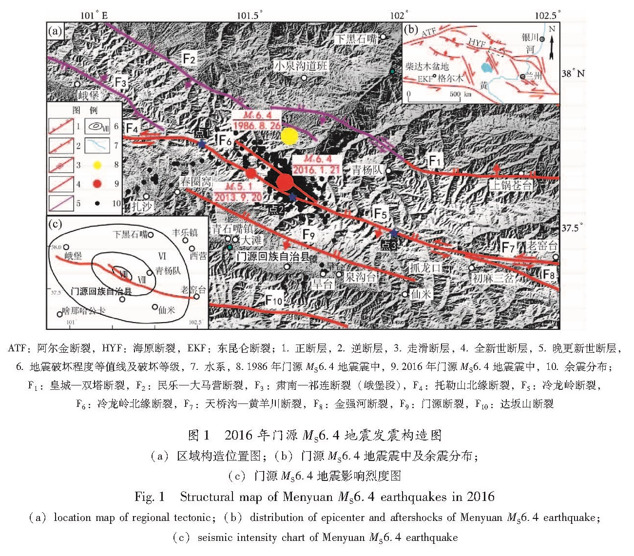
在遥感影像上断裂的识别和解译要以断裂的空间结构信息为主,结合影像波谱特征和地学知识进行综合分析。对于色调不明显的区域性断裂,需要综合断裂构造直接标志与间接标志分析、影像色调、色相结构异常界面、地质—地貌综合分析、地表水系结构异常分析等方法进行识别及信息提取。结合断裂断错地貌,如冲沟、阶地、拉分盆地、冲洪积扇、山脊、断层崖等变形标志(张之武等,2008; 罗国文等,2012; 马丹等,2014; 李天龙等,2014)。走滑活动断裂中,常见的地貌标志有地层、山脊错动、拉分盆地、水系、阶地的同步转折、冲沟错动及断头断尾沟以及冲洪积扇的形态变化(马丹等,2014)。笔者利用高分1号遥感影像和googleearth影像数据,选择冷龙岭断裂上距离震中较近断错线性地貌较明显的3个点进行了遥感解译工作。
3.1 春圈窝东北解译点1
在春圈窝东北约8.5 km处的解译点1,山峰陡峻,沟谷深切,山前广泛发育晚更新世及全新世以来形成的冲洪积台地,断裂带南侧约300 m处,硫磺沟近东西向发育,宽150~200 m; 山前发育4条不同规模的小冲沟,冲沟多自北向南流动切割冲洪积台地,最终汇于山前硫磺沟中。在冲沟形成后,冷龙岭断裂带持续活动,明显断错山前发育的微地貌,主要表现为断裂左旋错断了冲沟和冲洪积台地,并在扇体上保留了多期断层断错形成的断头沟(图2)。
从东往西统计分析地貌的左旋累计位错量可以看出,最西侧的冲沟位错与新的冲洪积扇位错近一致,分别为31 m和35 m; 第二条沟断错地貌现象最完整,保留了二期断层活动遗迹,形成了1条断头沟,最大位错量为135 m,最新冲沟位错为50 m; 最东侧冲沟处,断层断错冲沟和冲洪积扇扇体,冲洪积扇位错量为22 m和36 m,扇体右岸受侵蚀较严重,以左岸位错量为准,冲沟位错为65 m。
图2 春圈窝东北断裂断错地貌解译
Fig.2 Fault offset landforms interpretation in northeast of Chunjuanwo Village
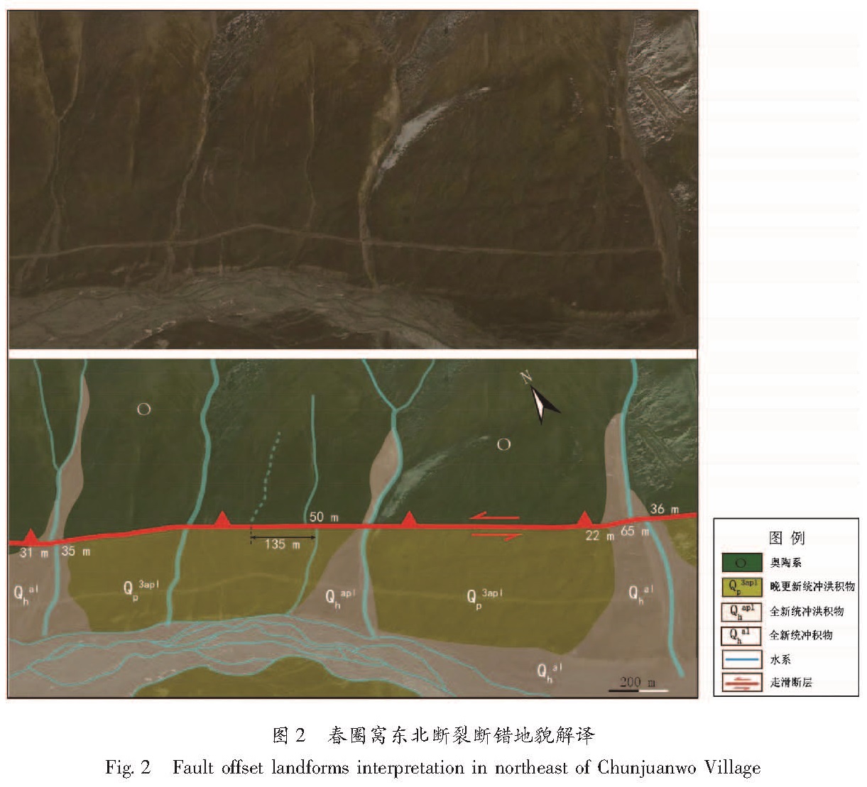
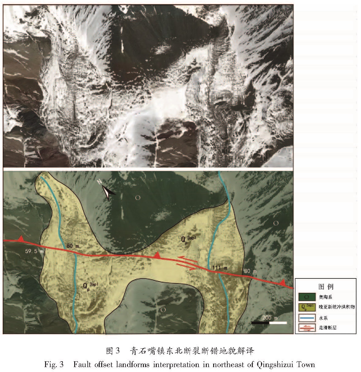
3.2 青石嘴镇东北解译点2
在靠近震中附近的青石嘴镇东北约10 km的解译点2,地貌发育较为简单,通过影响色调差异,解译出了断裂带附近的基岩山脉及两个冲洪积扇体,扇体同时形成,并被由北往南发育的新生性冲沟所切割,扇体前缘宽300~400 m。在该解译点冷龙岭断裂线性特征明显,断裂左旋断错冲沟和冲洪积扇体,断层上、下盘呈现不同的色调。通过影像解译(图3),可以获得解译点冲沟累计位错分别为80 m和111 m,扇体左旋位移量为59.5 m和80 m,说明冲沟与冲洪积扇形成后断层活动,位错量一致。
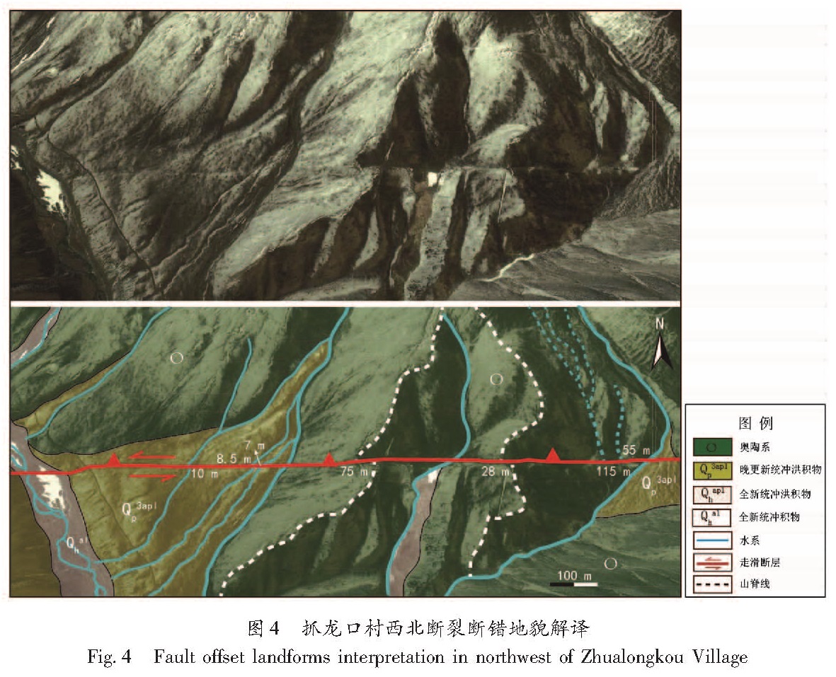
3.3 抓龙口西北解译点3
在冷龙岭断裂东端抓龙口村西北约5 km处的解译点3,解译点主要为山前冲洪积地貌,出山口处发育2个规模不同的冲洪积扇,最大扇体前缘宽度达500 m,跨断层发育6条小冲沟,部分冲沟在构造和气候的作用下切割扇体,而后断裂的进一步活动断错扇体和冲沟。主要表现为断裂左旋错断了冲沟和山脊,并且断层断错形成多条断头沟和断尾沟(图4),从西向东统计分析地貌的累计左旋位错量可以看出,最西侧的冲沟位错量很小,一般在10 m左右,通过解译测量获得其水平位错量分别为10 m、8.5 m和7 m; 东侧山脊被断层左旋断错,水平位移量为75 m; 再向东约100 m,山脊左旋位错,位移量28 m; 最东侧冲沟处,断层断错冲沟并形成二期断尾沟,累计位错量分别为115 m和55 m,最新冲沟无位错。
图3 青石嘴镇东北断裂断错地貌解译
Fig.3 Fault offset landforms interpretation in northeast of Qingshizui Town
3.4 断裂微地貌遥感解译特征
前人野外实际调查认为沿断裂断错水系十分发育,最大左旋错动达3.25 km,最小仅7 m。山脊错动也很明显,位错量110~280 m。冰碛台地左旋错动达135 m(何文贵等,2000)。
本次遥感解译工作显示,冷龙岭断裂带水系的断错和拐弯,以及其他线性标志的断错现象也非常明显。自北向南发育的冲沟被断层系统地断错或拐弯,通常在单条上游河道有2~3条断错形成的断头沟或断尾沟,说明断层的左旋位错量在不断累积。解译点1附近地貌累计水平位错量从老至新分别为135 m、50~65 m和31~36 m; 解译点2附近地貌累计水平位错量从老至新断错量分别为111 m和59.5~80 m; 解译点3附近地貌累计水平位错量从老至新断错量分别为115 m、55~75 m、28 m和7~10 m。解译结果与前人野外实际调查的部分结果较为一致,说明本次遥感解译工作可信度较高。通过不同地段的遥感解译资料更为细致地划分出了断层多期的活动。
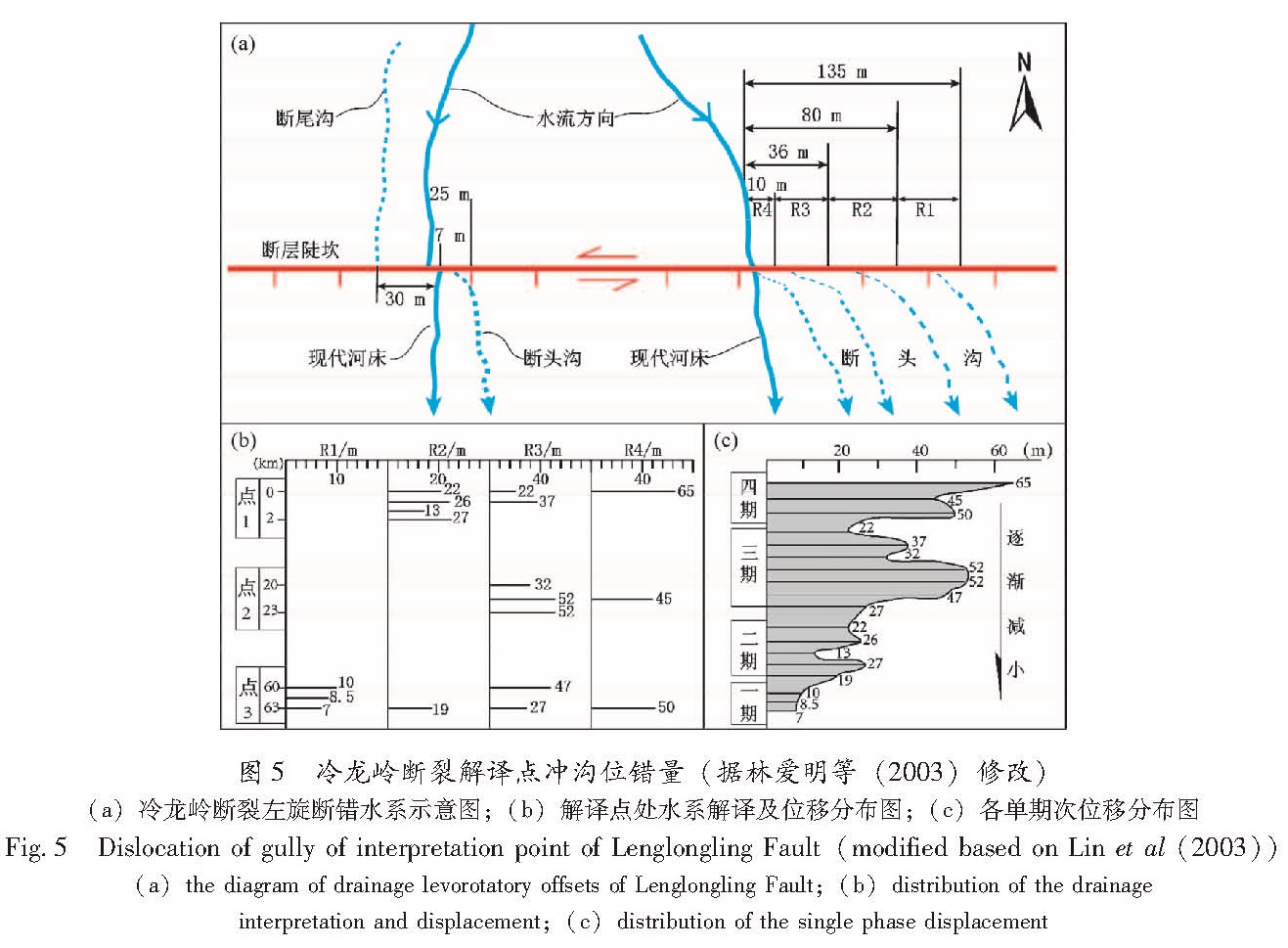
综合分析冲沟的系统位错表明了冷龙岭断裂水平位移的活动期次(图5a),其中R1-R3代表记录的两条废弃的下游河道的位错可能代表至少一次的地震断层活动; R3为现代河道的断错量,可能是由最近一次的地震事件形成; R1-R3的位移量的总和代表河道从断层位移开始至今的总位移量。通过影像解译认为,距离本次地震震中较近的冷龙岭断裂具有典型的左旋走滑特征,垂向运动分量小,晚更新世以来有过4期水平位错活动(图5b),从老至新其位错量逐渐变小,分别为45~65 m,22~52 m,13~27 m及7~10 m(图5c)。
图4 抓龙口村西北断裂断错地貌解译
Fig.4 Fault offset landforms interpretation in northwest of Zhualongkou Village
图5 冷龙岭断裂解译点冲沟位错量(据林爱明等(2003)修改)(a)冷龙岭断裂左旋断错水系示意图;(b)解译点处水系解译及位移分布图;(c)各单期次位移分布图
Fig.5 Dislocation of gully of interpretation point of Lenglongling Fault(modified based on Lin et al(2003))(a)the diagram of drainage levorotatory offsets of Lenglongling Fault;(b)distribution of the drainage interpretation and displacement;(c)distribution of the single phase displacement
前人在讨拉柴陇至假墙丫豁的20 km地段内,揭露出全新世有3次古地震事件,距今分别为5 926 a、3 885 a和公元1 540 a(何文贵等,2001)。断层上古地震事件与遥感解译确定的四期水平位错活动之间的关系,有待今后的测年工作进一步确定。