本文选取四川“4·20”芦山地震震区发生的地震滑坡作为实验对象。该次地震发生在龙门山断裂带,是四川成都平原区域地震的典型代表,其研究成果可以进一步用于成都平原周边山区的滑坡灾害预防、规划等应用,具有较好的应用价值。本研究以上述区域为实验区,期望能够逐步完善基于高分辨率低空遥感技术的地震滑坡灾害解决方案。
具体步骤如下:首先,利用所收集的滑坡灾害的历史数据资料,滑坡影像、地表覆被、地质环境等各类信息,考虑到应急情况下灾区遥感数据源的单一性,研究地震滑坡灾害低空遥感影像样本库构建方法; 然后,为了快速、准确地提取当前无人机影像地震滑坡信息,引入迁移学习机制,完成特征知识从旧影像到新影像的迁移,完成地震滑坡信息的提取; 最后再进行提取精度的评估。
1.1 地震滑坡灾害样本库构建
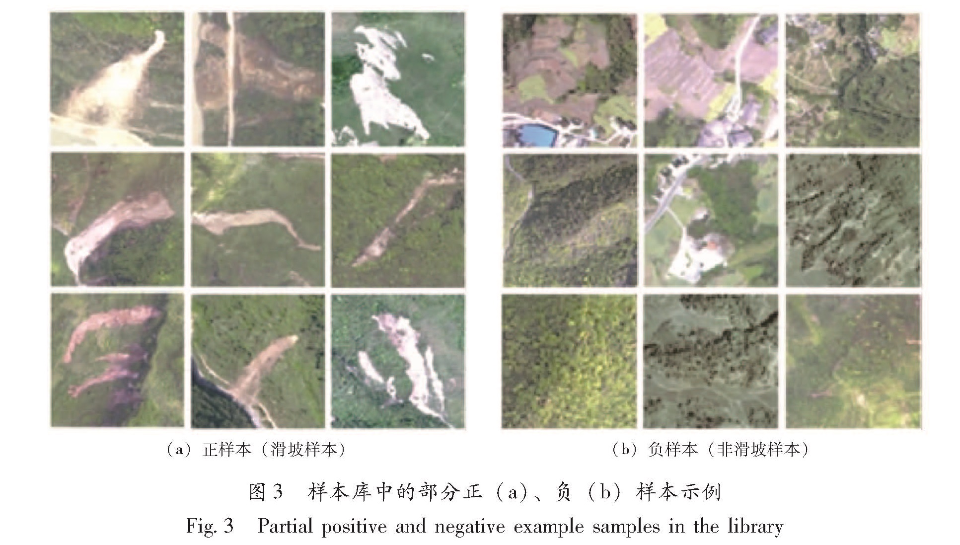
无人机影像分辨率高,研究区涉及到的影像数量多,滑坡样本库的构建工作包括:确定灾害样本点标签、边界范围的确定、属性赋值、裁切影像、编码存储等,如果按照常规方法构建地震滑坡样本库的建设需要耗费大量人力物力,且效率较低。对样本库构建流程进行分析可发现,确定灾害样本点标签、边界范围的确定、属性赋值需要人工操作,因为该几步操作存在大量不确定性; 裁切影像和编码存储可以通过计算机自动实现,本文基于ArcPy(ArcGIS Python二次开发包)二次开发实现影像自动裁剪和编码入库。地震滑坡灾害样本库建立流程如图1所示。
图1 地震滑坡灾害样本库建立流程
Fig.1 The workflow of earthquake landslide disaster sample library establishment
1.2 无人机高分影像滑坡信息提取
计算机机器学习是近年来飞速发展的一个研究领域。把机器学习应用于图像处理、图像理解中通常需要提供足够的训练样本,否则后续的分类精度难以得到保证,甚至导致分类模型结果不收敛,信息提取难以完成(Cheng et al,2013; Fiorucci et al,2011)。本文研究发现,由于滑坡灾害影像相较于自然影像可获得的数据量少,直接将常规机器学习应用到滑坡信息提取中存在困难。虽然研究区涉及到的影像数量多,但可供采集的滑坡样本却较少,导致很难获得足够多满足模型训练条件的训练样本数据。而且,常规机器学习应用的提前是同分布假设,在实际应用中发现在很多领域难以达到同分布假设,甚至会出现训练样本过期等问题。需要对不符合要求的样本进行重标注,又会导致工作量和作业成本的大幅增加。
为解决上述问题,迁移学习(Transfer Learning)在深度学习的基础上发展起来。简单来讲,迁移学习的本质就是从一个模式中通过深度学习获取的知识迁移应用到另一个应用模式中。因此,迁移学习不像常规机器学习一样需要同分布假设。根据迁移学习迁移的对象不同可划分为4类:依据实例的迁移学习、基于特征的迁移学习、根据参数的迁移学习和基于关联知识的迁移学习。
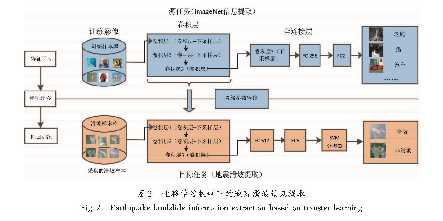
根据建立的样本库情况,本文采用基于特征的迁移学习方法。当前可搜集到带标签的自然图像库较多,本文选取经典的由斯坦福大学计算机视觉研究中心标注完成的ImageNet库,该图像库涵盖了上百万的已标注图像。首先,通过在ImageNet库中建立深度卷积神经网络获得特征提取方法; 然后,将获取的特征提取方法通过特征迁移的方式转移到无人机高分辨率遥感影像的滑坡特征提取过程中。图2为迁移学习机制下的地震滑坡信息提取,主要包括特征学习、特征迁移以及滑坡灾害信息提取3部分。
图2 迁移学习机制下的地震滑坡信息提取
Fig.2 Earthquake landslide information extraction based on transfer learning
1.3 精度评价
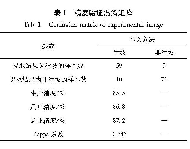
在进行遥感影像信息提取时,难免会产生误差,其原因很多,比如不同传感器信息获取方法的不同、影像分辨率的不同或者目标地面物体提取中分布空间特征的影响等。因此非常有必要对误差形成的原因进行分析,从而了解信息提取结果的实用性(许冲,2013; Lu,et al,2011)。
遥感影像信息提取精度的定义是提取地物信息的准确度。提取精度是检验提取方法、模型规则是否可靠的通用标准。通过信息提取精度的计算与分析,可以评判方法与结果的优劣,有助于信息提取模型的修正。通常,遥感影像信息提取精度评价的方法有2类:一类是通过人工目视图像定性评价; 另一类是通过实地调研或已有可靠精度样本数据通过计算的方法定量进行精度评价。由于本文选用的无人机影像有较高的空间分辨率,所以采用定量计算滑坡信息提取的精度,通过可靠的评价样本数据计算信息提取结果的总体精度和Kappa系数等指标(薄树奎,丁琳,2010; Foody,2002)。