发震应力条件与地震危险性判定,选用组合危险性判据A1~A6,根据GPS地形变场,Kaiser效应应力场和数模拟合反演的形变场、应力场,取读所需的各参量,进行地震危险性判定。
3.1 A1——破坏接近度
若一点的Mohr圆和Coulomb(τ1=S0+μσ)线相切,则破裂必定发生(也意味着该点处于地震危险状态)。
定义破坏近近度n=τ'/τ(5)
式中:τ'为某部位的数模计算剪应力; τ为对应该部位的岩土抗剪强度,即:
τ=σtgφ+C(6)
式中:σ为部位所受的正应力; φ为该对应部位岩土体的内摩擦角; C为该对应部位岩土体的内聚力。
根据破坏接近度n的定义,n<1表示材料未破坏(该部位处于安全稳定状态),反之n>1,则表示材料破坏(局部破坏——该处处于危险),从n接近1的程度,判定地震危险临近度。
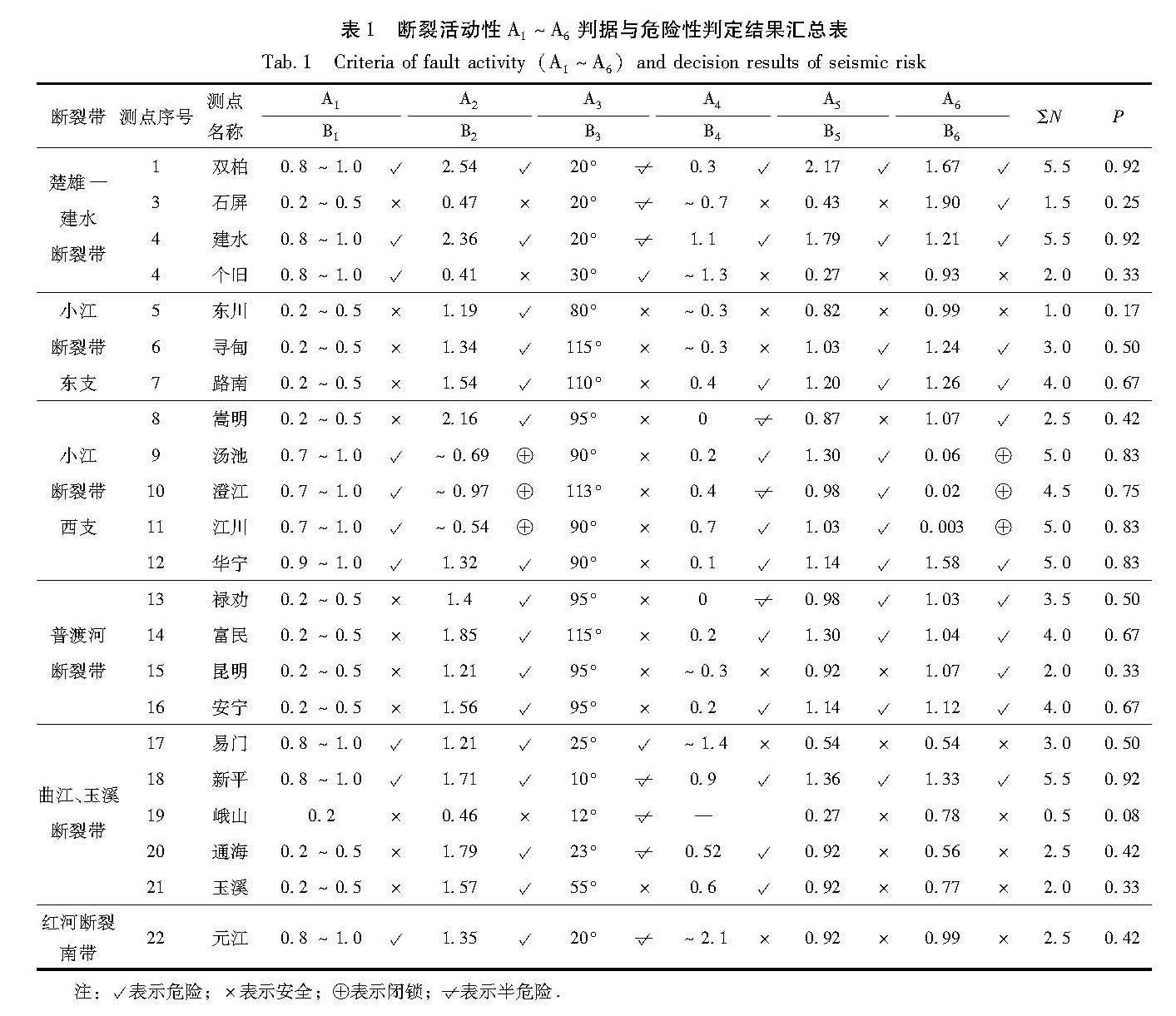
从表1可见,本研究区内如果撇开模型靠近边界的地带不管,重点考虑本项目主要研究区,大范围内n值只有0.2~0.5(表明未出现大范围的危险)。而相对临近1的部位有:楚雄—建水断裂带,小江断裂西支嵩明—华宁段。接近度只表示点与点的相对比较,因为岩土抗剪强度只是个估计值。
3.2 A2——本构关系
摩擦阻力τ与摩擦滑动速度V的关系遵从于Dieterich公式:
τ=τx+θ+Aln(V/V*)(7)
式中:V*为一个任选的正的参考速度; τx,A是正的经验常数; θ是状态变量。从式(7)可见,其中主控因素是速率对数lnV对摩擦阻力τ的影响,而视其它量为常量,假定τ∝lnV或τmax∝lnV,由文献可见其2者有相关关系,现定义断裂活动状态系数为Bn=(τmax/lnV)÷平均(τmax/lnV),式中:Bn>1表示断裂处于活动状态(高剪应力、高速率); 0<Bn<1表示处于蠕滑状态(低剪应力、大速率); Bn<0表示处于闭锁状态(高剪应力、小速率)。
从表1可见,小江断裂西支汤池—澄江—江川处于闭锁,石屏、峨山处于蠕滑,其它各点处于活动状态。
3.3 A3——临界走向断裂
据丁文镜(1982),黄福明等(1995)研究,并用Coulomb与Mohr准则、Byerlee定律分析对比可知,在给定(或已知)的应力场中,不同走向的断裂其发展成发震断裂的可能性是不相同的,只有满足临界走向的断裂,它的发震几率才较大。
对于岩体破坏,它遵从Coulomb准则:
tgφ=μ(8)
φ=90°-2α(9)
式中:φ为破裂内摩擦角; μ为摩擦系数; α为最大主应力方向与临界破裂面走向夹角,小于45°。对于大多数岩石μ=0.6~1.0,也就是它所对应的α角范围为22.5°~30°。
本研究区的历史强震绝大多数沿本区主干断裂发生,它的发震机理更接近于摩擦滑动,它遵从于Byerlee定律的可能性更大。Byerlee定律中μ=0.6~0.85,它对应的临界断裂走向与最大主应力方向夹角α为25°~30°时,该断裂处于临界摩擦活动状态。因此α=30°~25°为容易发震的夹角(下称“易震角”); 当夹角α为31°~45°或0°~24°时也可以发震(下称“可震角”)。当夹角α为其它角度时为不易发震角。
从表1可见,个旧、易门处于“易震角”,双柏、石屏、建水、新平、峨山、通海和元江处于“可震角”,其它点位于不易震角。也就是说个旧 、易门发展成发震的可能性较大,双柏、石屏、建水、新平、通海次之,其它部位较小。
3.4 A4——最大剪应力τmax与平均应力σm
平均应力σm=(σ1+σ3)/2,类似于围压的作用。平均应力值愈大,产生剪切破裂所需的差应力就愈大,因此愈不容易发生破裂。2者的作用相反,剪切破裂能否发生,受这2种因素的制约,昆明—玉溪地区最大:
τ^-max=A+Bσm(10)
式中:τ^-max为回归得到的最大剪应力; σm为相应地点的平均应力。σm=(σ1+σ3)/2中:σ1为最大主应力; σ3为最小主应力; 当τmax>0时,表示危险。
从表1可见,双柏、建水、新平、通海、玉溪、汤池、澄江、江川、华宁、富民、安宁等地具有发生剪切破裂的围压条件,相对危险(即τmax-τ^-max>0),反之其它点相对安全。
3.5 A5——剪应力集中系数τn
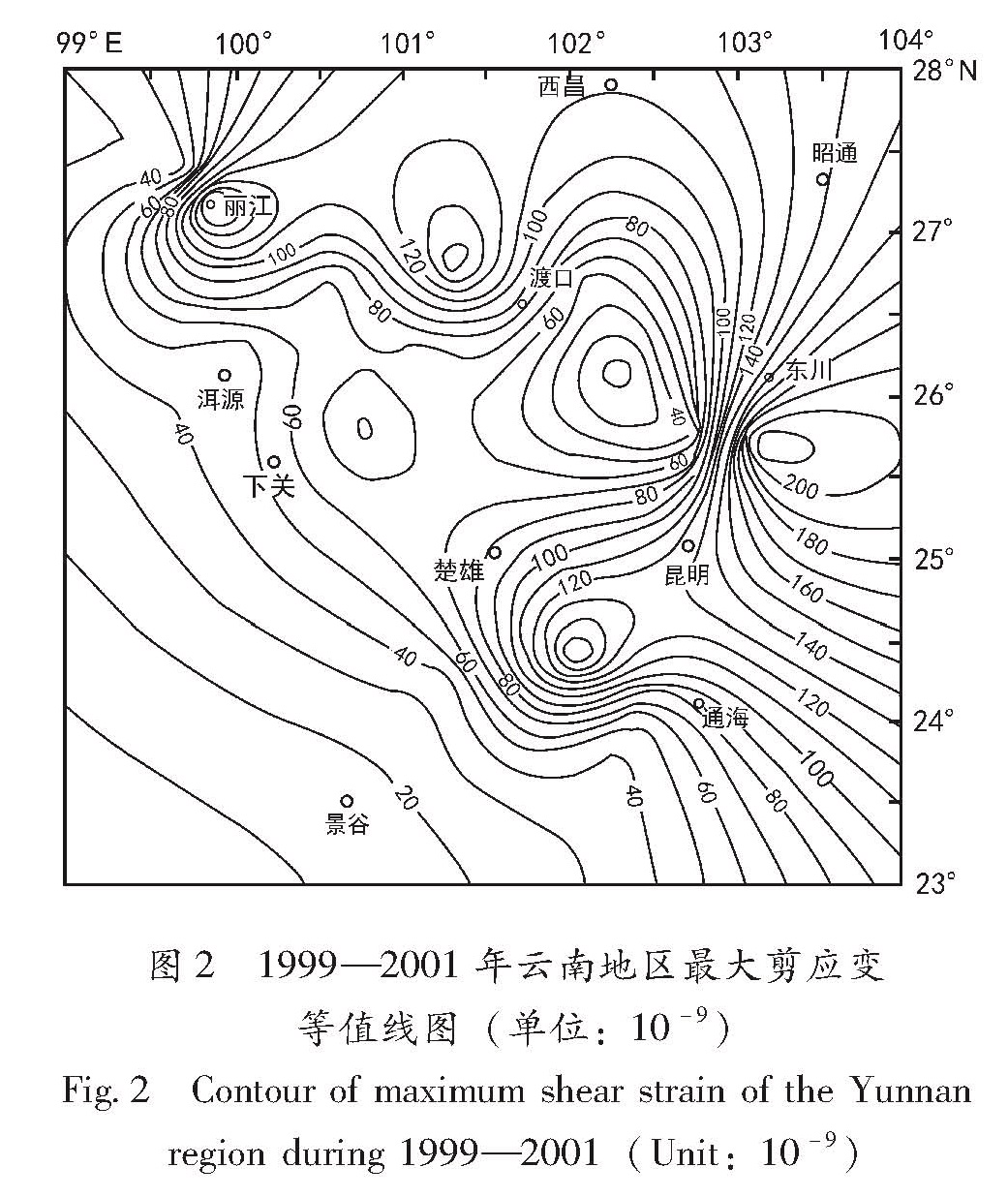
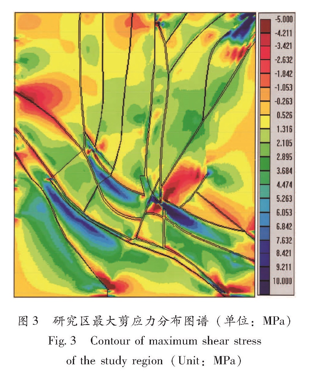
最大剪应力愈大,表示其集中程度愈高,愈容易发生剪切破裂。本研究区的最大剪应力分布情况详见最大剪应力分布图(图2)。
剪应力集中度系数为:
τn=τmax/τ0(11)
式中:τmax为某部位的最大剪应力; τ0为本研究区的区域平均最大剪应力。剪应力集中度系数τn>1表示应力集中; τn<1表示应力不集中。一般集中与松驰之间的应力梯度带也可能发震,作为危险性判据; 也有学者认为在应力松驰点也可能发震。但从材料力学和岩石力学的角度看,应力集中部位发生破坏的可能性较大,因此本研究也选应力集中为危险性判据。从表1可见最大剪应力相对集中的部位有双柏、建水、新平、汤池、江川等。
3.6 A6——断层两侧相对位移速度集中度系数Vn
定义断裂两侧相对位移速率集中度为:
Vn=V/V0(12)
式中:V为某部位断裂两侧相对位移速率; V0为本研究区域平均断裂两侧相对位移速率; Vn>1表示速率加速集中(危险),Vn<1表示位移速率不加速集中(不危险),从表1可见,位移速率加速的部位有石屏、双柏、建水、新平、寻甸、华宁等。
表1 断裂活动性A1~A6判据与危险性判定结果汇总表
Tab.1 Criteria of fault activity(A1~A6)and decision results of seismic risk
3.7 A1~A6判定结果汇总
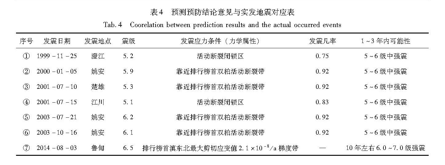
根据GPS地形变,Kaiser效应地应力实测值结合数模反演应力场形变场取读相应的应力应变场参量,按危险断裂活动组合判据A1~A6的计算公式(5)~(12)进行运算,并将危险性判定结果汇总为表4。
从表1可看出各点的危险性判定结果,竖列表示同一判据不同点的判定结果; 横行表示同一点位,不同判据的判定结果。
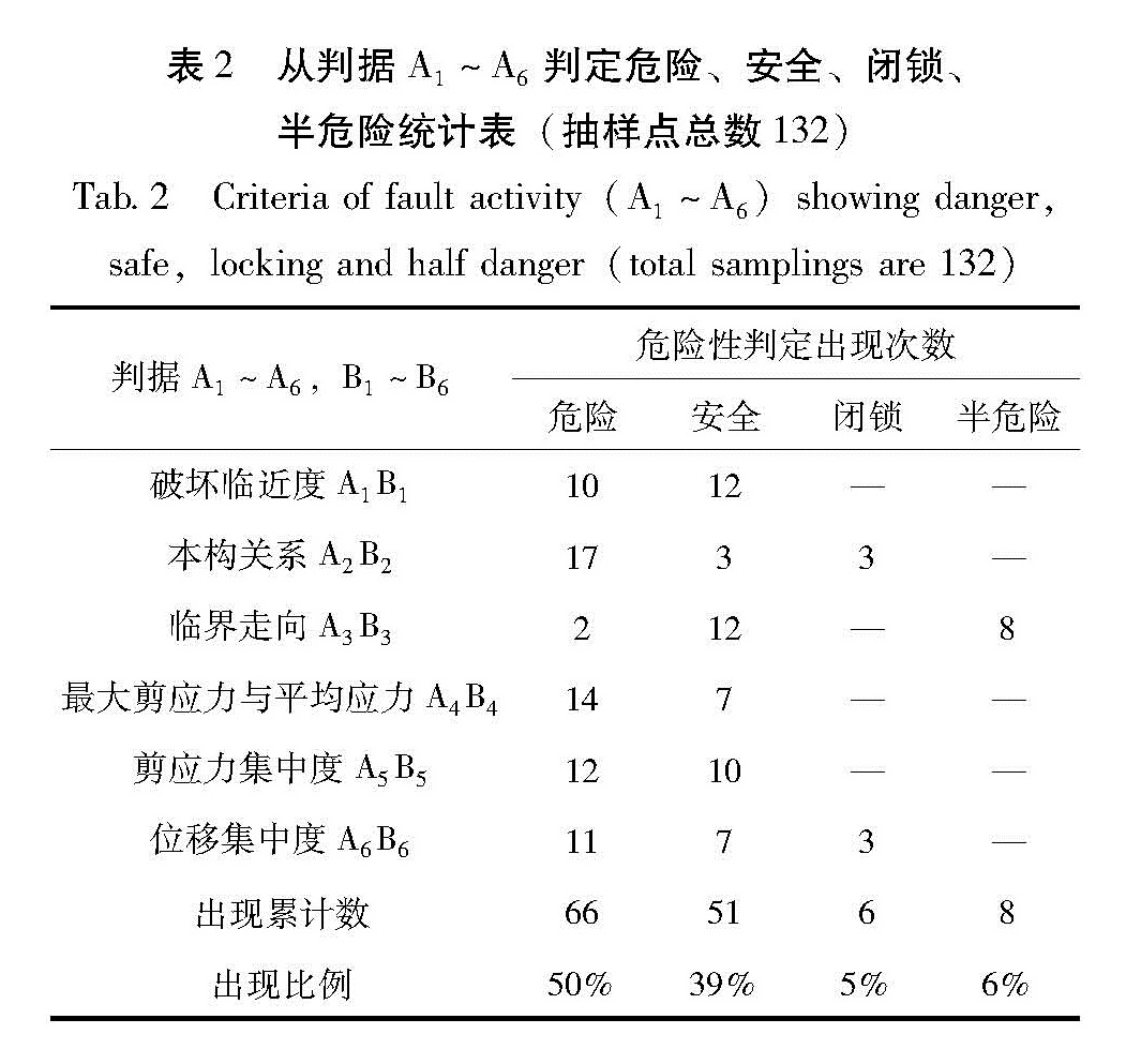
表2 从判据A1~A6判定危险、安全、闭锁、半危险统计表(抽样点总数132)
Tab.2 Criteria of fault activity(A1~A6)showing danger,safe,locking and half danger(total samplings are 132)
从统计表2可见,危险(包括闭锁)、安全(包括半危险)大约各占1/2。危险这一半还有待于细判细分,最终2/3以上的点都不具备发震应力条件,自然也就被排出预测预防区。
3.8 发震几率
为减少判断的不确定性,笔者采用GPS形变与Kaiser应力联合判定判据A2,目的是寻找并区分多震区中的活动段(高形变对应高应力段)、闭锁段(小形变对应高应力段)、蠕滑段(高形变对应低应力段)。为了与断层水平位移滑动速率对应引入判据A6。以上6个判据分别反应危险性的一个侧面,采用6个判据联合,6个判据之间可能互补(减少片面性),统计6个判据对应判定点判据出现的几率大小和分布,综合判定危险性的程度和区段,判据出现的几率,简称为发震几率。
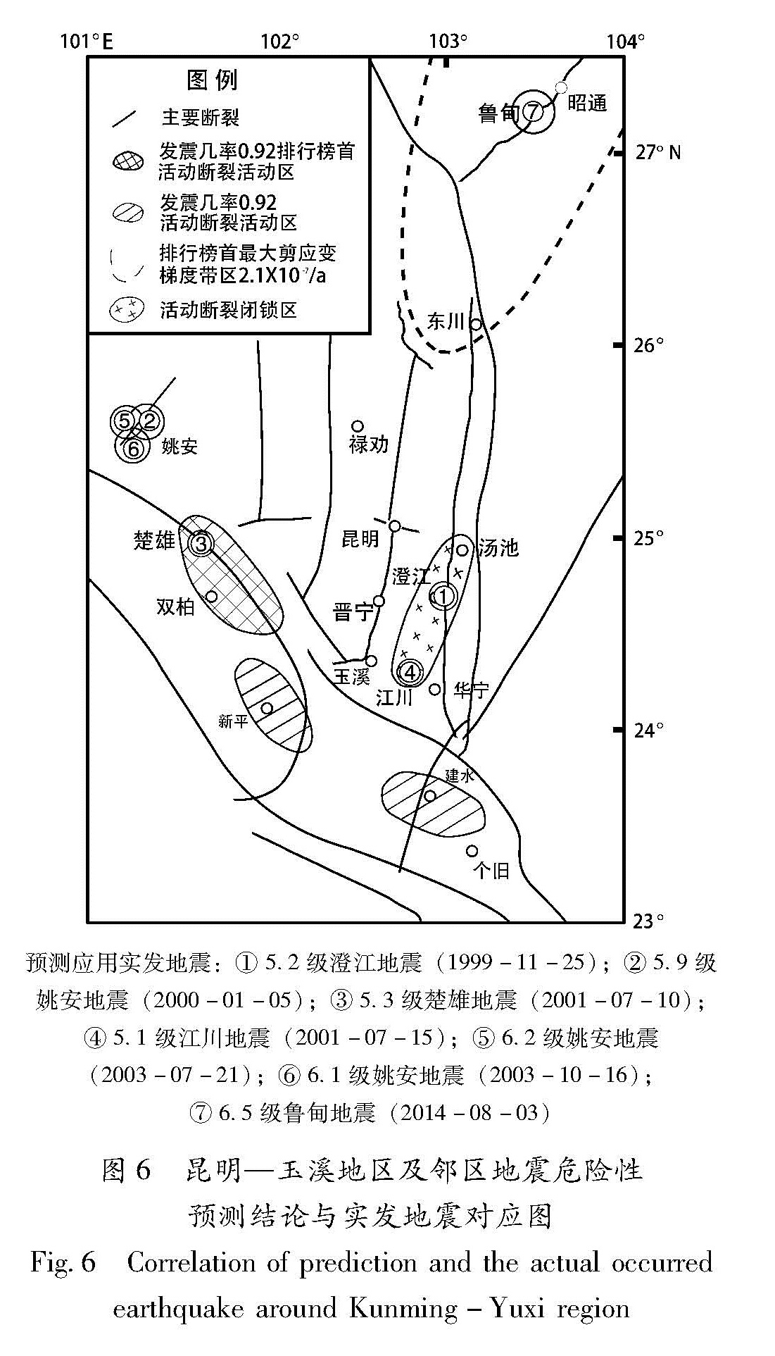
单一判据反映的只是危险性的一个侧面,具有片面性。本文利用所列的判据A1~A6,对研究区22个抽样点进行综合判定。由表1可知:较高的潜震部位有双柏、建水、新平(几率为0.92),其次汤池、江川、华宁(几率为0.83)。根据判据A2判定,汤池、澄江、江川处于闭锁段,个旧、峨山处于蠕滑段。
3.9 发震时间临近度
选用Byerlee定律(梅世蓉,1985)将Byerlee摩擦强度(Byerlee,1978)作为临近地震危险性的应力场限定条件,作Byerlee线(图5)(τ=0.85σ,τ=0.5+0.60σ)。由图5可见,江川测点和昆明—玉溪集合,同法求作各测点的Mohr圆(略),其Mohr圆切线(K线)均位于临界Byerlee线(B线)之下,也就是应力状态尚未临近摩擦强度。
图5 昆明—玉溪地区及邻区剪应力τ与正应力σ关系图
Fig.5 Relationship between area map of shear Stress(τ)and normal stress(σ)around the Kunming-Yuxi region
为表明各测点的差异性,假定各拟合τ=S
0+μσ,式中S
0近似相等,与Byerlee公式写为τ
*=S
0+μσ中S
0也相近,那么定义危险性临近度n≈τ/τ
* ≈μ/μ
*,按测点求μ/μ
*(取μ
*为0.60,危险性临界B线),列成
表3。
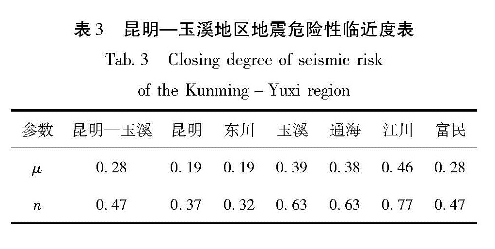
表3 昆明—玉溪地区地震危险性临近度表
Tab.3 Closing degree of seismic risk of the Kunming-Yuxi region
从表3可见,临近度相对较高的地点是江川(n=0.77),其次是通海、玉溪(n=0.63),再次是昆明—玉溪地区(n=0.47),富民(n=0.47),昆明(n=0.37),东川(n=0.32)。
3.10 发震震级
昆明及邻区的北部和东北部为张应变区,最大张应变速率为5×10⁻⁸ /a; 中南部为压应变区,最大压应变速率为1.1×10⁻⁷ /a。形成了4个主压应变高值区:昆明东北地区、昆明以南地区、下关地区和渡口地区,其中昆明东北地区和昆明以南地区的最大主压应变速率为1.1×10-7主压应变速率/a。在昆明东北地区和渡口地区形成了2个主压应变的高梯度带,出现了4个最大的剪应变高值区:昆明东北地区、昆明以南地区、渡口西北和丽江西北地区,其中滇东北地区最大为2.1×10-8 /a。根据应变场的强度估计,已经具备发生6.0~7.0级中强地震的条件,发生7.0级以上大地震的条件尚未完全具备(李延兴,郭良迁,2002)。
根据昆明、玉溪、江川等点位Kaiser效应法地应力测量结果,参照1996年丽江7.0级地震的方法,分析判定与Byerlee临界摩擦强度线,Sibson(Sibson,1974; 李四光,1977)线性摩擦强度公式的临近程度,得出:(1)昆明—玉溪地区3~5 a内发生MS>7.0地震的可能性较小;(2)以江川为中心(澄江、汤池)地区,其应力值相对较高,估计3~5 a内有发生中强震及中小地震增多的可能性(黄永祥等,2002c,d)。