1.1 资料收集与数据处理
本文共收集到2010—2017年西藏地区15个“陆态网络”连续站数据、中国地震局第一监测中心(以下简称一测中心)3个新建连续站数据、ARIA团队建立的尼泊尔连续监测网络(由NASA UNAVCO网站提供原始观测数据)28个连续站和一测中心在尼泊尔地震前后观测得到的震前震后20个流动站数据(观测时间分别是震前40 d和震后30 d内),如图1所示。基于以上丰富的GPS连续和流动观测数据,采用BERNESE软件进行处理,分别计算了同震位移场、跨喜马拉雅构造带2侧典型基线时间序列以及震前、震后2期速度场,以此分析喜马拉雅构造带中段近期地壳形变特征和趋势。
在数据处理策略方面,本文利用BERNESE软件,将所有流动站、连续站数据放在一起进行不分区模式处理,同时选取全球框架下较为稳定的约37个IGB08核心站在统一框架下进行整体平差,这样避免了GAMIT软件因为每次只能处理不超过100个站而必须进行分区造成的精度损失,提高了数据解算精度。2种软件和解算策略的精度及优缺点对比郭炳辉等(2016)有所提及。
图1 收集到的连续站及流动站数据站点分布
Fig.1 Continuous and regional GPS stations distribution map
1.2 同震位移场
图2为同震水平位移场结果,图中显示:主前山断裂带(MFT)以北区域首先具有整体向南运动的趋势,靠近震中区域的站点水平位移方向与主前山断裂带MFT走向近垂直,且最大水平位移达到1.84 m(KKN4站点,该站点位于震中东边40 km处); 西藏南部地区的流动站点的水平位移方向相对于尼泊尔境内的连续站点的位移方向,发生一定角度的改变,且呈现两侧向最大位移区域汇聚的趋势。
因此,从GPS同震水平位移场可以看出该地震断层运动以逆冲倾滑为主,与USGS提供主震震源机制解的断层几何参数及震间GPS地壳形变场特征相吻合,属于典型的喜马拉雅型(低角度逆冲型)地震。这也与国内外学者得到的GPS和InSAR联合解算的同震位移结果基本一致(赵斌等,2015; 占伟等,2015; 单新建等,2015)。
图3为同震垂直位移场结果,由图可知,主震震中与最大余震震中连线以南变形位移区域具有较大的垂直向上运动,最大位移达1.25 m左右(KKN4站点); 主震震中与最大余震震中连线以北具有垂直向上和向下2种运动趋势,KKN4站点以北的CHLM站点具有近60 cm垂直向下运动,CHLM站点以东的J041站点具有近8 cm垂直向下位移; 然而远离最大变形区的西藏南部具有垂直向上运动的趋势,最大形变量可达1~2 cm。
同时,主前山断裂带MFT的南部区域的站点GPS垂直位移几乎为零,表明该地震并没有破裂到地表引起地表形变,这也与国内外测震科学研究小组基于远场地震波资料快速获得震源机制解及滑动分布模型中显示的该地震纯逆冲、低倾角、没有破裂至地表的基本特征相吻合(赵斌等,2015)。
表1给出的GPS同震位移场结果,全部为实际解算结果利用时间序列分析方法去除了趋势变化得到的结果,利用更长时间的数据积累拟合出更优的时间序列模型,从而得到较为准确的同震位移场结果(Wu et al,2016)。
图2 GPS获得的尼泊尔MW7.8地震同震水平位移场
Fig.2 Coseismic horizontal displacements caused by the 2015NepalMW7.8,earthquake,inferred from GPS observations
图3 GPS获得的尼泊尔MW7.8地震同震垂直位移场
Fig.3 Coseismic vertical displacements caused by the 2015 Nepal MW7.8,earthquake,inferred from GPS observations
表1 GPS同震位移场结果
Tab.1 Coseismic displacements of continuous GPS stations
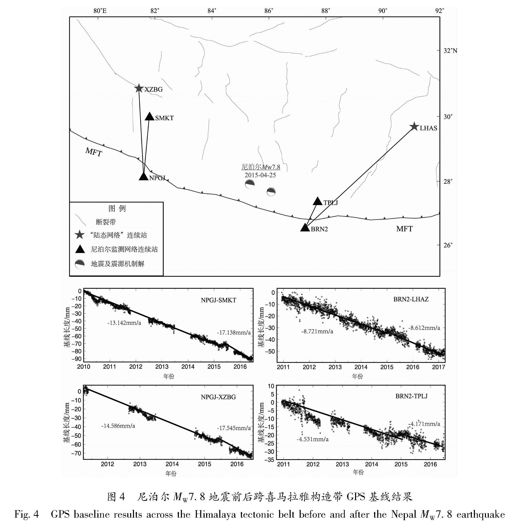
图4 尼泊尔MW7.8地震前后跨喜马拉雅构造带GPS基线结果
Fig.4 GPS baseline results across the Himalaya tectonic belt before and after the Nepal MW7.8 earthquake