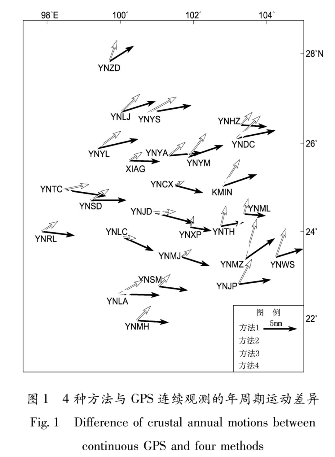
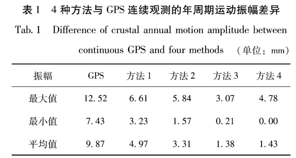
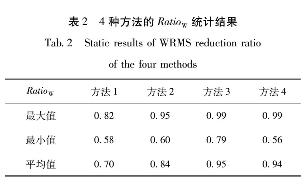
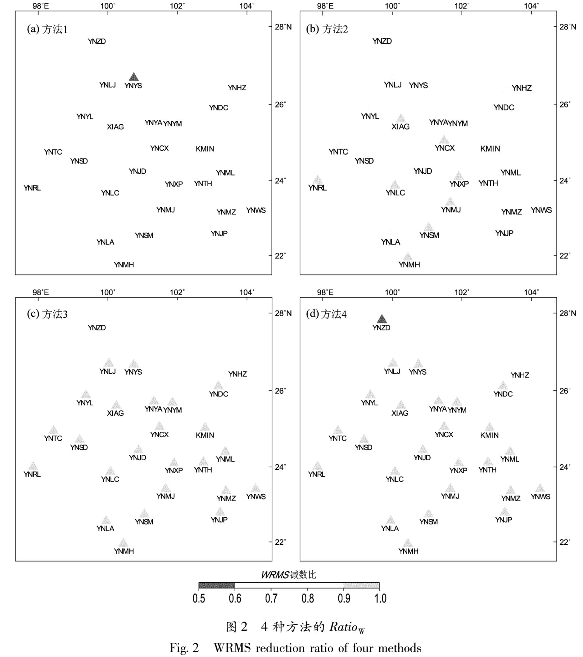
常用的垂向年周期运动获取方法分为2类,一类是根据一些物理模型(如负荷模型或者GRACE)直接求解某一空间位置的垂向年周期运动参数; 另一类是对区域内GPS连续站实测的垂向年周期运动参数进行空间内插。本文选用4种GPS垂向年周期运动获取方法,分别为:
(1)方法1:负荷模型方法。地球表面各种负荷变化是GPS垂向周期性运动的主要影响因素,而在云南地区,陆地水的质量变化是该区域GPS垂向周期性运动的主要影响因素(姜卫平等,2013; Jiang et al,2017),因此笔者从EOST Loading Service http://loading.-ustrasbg.fr/ditrf_form.php.下载了2010—2015年全球陆地水文负荷模型(GLDAS)解算的垂向位移格网数据(CM),数据空间分辨率为0.5°×0.5°,时间分辨率为3 h。基于云南地区各格网点垂向位移时间序列,采用线性+年周期+半年周期方法拟合得到各格网点年周期运动正弦波振幅A和余弦波振幅B,为了与GPS连续站结果比对,采用多核函数法空间插值获取云南地区26个GPS连续站所在空间位置的年周期运动正弦波振幅A1和余弦波振幅B1。
(2)方法2:GRACE模型方法。利用GRACE数据给出的地球重力场球谐系数(Bruinsma et al,2010)和负荷勒夫数(Farrell,1972),可以根据弹性负荷形变理论获取负荷引起的形变信息(Wahr et al,1998; Kusche,2005; Fu et al,2012)。笔者按照Hao等(2016)的方法处理了CSR提供的GRACE-RL05数据:使用GCM05S模型去掉平均重力场; 用SLR观测的C20项系数项和一阶项系数替换模型中相应值; 采用高斯滤波方法去除高阶模型噪声,最终得到了26个GPS连续站所在空间位置的垂向位移结果(采样率为每月),采用线性+年周期+半年周期方法拟合得到各GPS连续站的年周期运动正弦波振幅A2和余弦波振幅B2。
(3)方法3:空间加权法。基于Zhan等(2017)给出的2010—2015年云南地区26个GPS连续站垂向位移时间序列(进行了预处理,包括去除了仪器更换等原因产生的突跳),采用线性+年周期+半年周期方法拟合得到各连续站年周期运动正弦波振幅A0和余弦波振幅B0。对某一个GPS连续站(记为插值点),根据其余25个连续站的年周期运动正弦波振幅A0和余弦波振幅B0,采用空间加权法插值得到插值点的年周期运动正弦波振幅A3和余弦波振幅B3:
A3=(∑25j-1(A0j)/(d2j))/(∑25j-11/(d2j)); B3=(∑25j-1(B0j)/(d2j))/(∑25j-11/(d2j))(1)
式中:dj为插值点与第j个GPS连续站的水平距离; A0j和B0j为第j个GPS连续站的年周期运动正弦波和余弦波振幅。
(4)方法4:多核函数法。该方法计算过程与方法3类似,对于每一个GPS连续站,都是其它25个GPS连续站垂向年周期运动参数(A0和B0)空间插值得到插值点的年周期运动参数(A4和B4),唯一的区别就是空间插值采用多核函数法。多核函数法由美国Hardy(1971)提出,其空间插值计算过程如下:
{f(λ,φ)=∑cjsj(λ,φ,λj,φj)=STC
sj(λ,φ,λj,φj)=d1.1j+1(2)
式中:f(λ,φ)为多核函数; sj(λ,φ,λj,φj)为多核函数; dj1.1为球面上2点间的大地线长度(单位为km); cj为待定系数(杨国华等,2012)。将所有可用的数据点作为核函数点,可以获得数学解析式,计算任一空间位置的结果。