3.1 店房地点
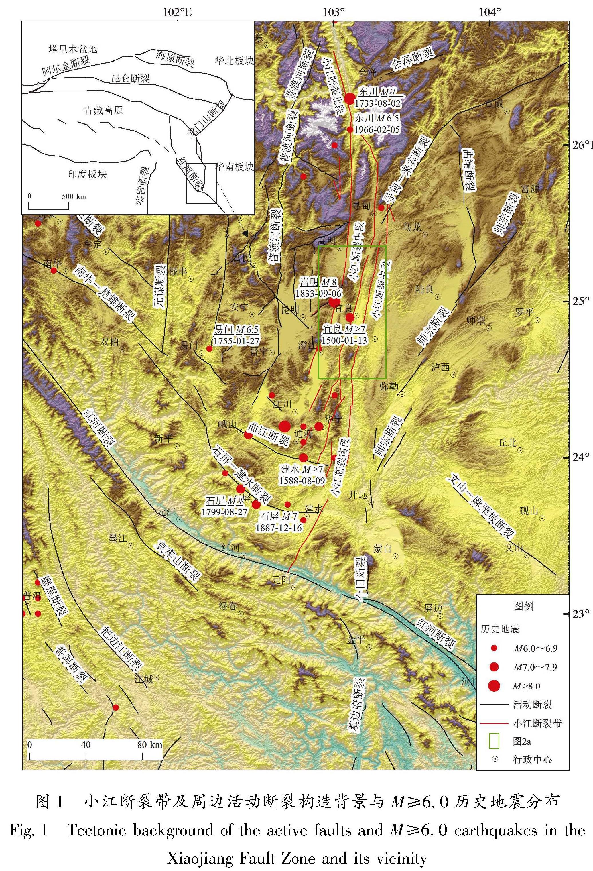
[KG0.15mm。]店房一带,冲沟左旋同步位错、闸门脊与断塞塘、断层槽谷、断头沟等断错地貌发育(图2b)。在(103°10'37.2″E,25°3'10.8″N)处跨断塞塘进行开挖,揭露出的地层单元特征如下:①灰色、浅灰色含砾砂层,中粗砂含量较高,砾块磨圆较好; [KG0]②该层含丰富砾块,根据颜色和物质成分又可细分为两层:②a为黑色含砾块淤泥层; ②b为钢灰色、浅灰色含砾块砂层,中粗砂含量较高,砾块磨圆次圆,大小不等; ③灰色含砾块砂层,所含砾块较②层明显减少; ④深灰色含砾块砂土层,颜色为深灰色,以砂为主,中粗砂含量较高。砾块磨圆度较好,大小不等,底部含磨圆度较好的砾石层,下界面较清晰; ⑤黄色含砾块黏土层,下界面呈渐变过渡; ⑥褐色表层耕作土。
探槽揭示出4条比较清晰的断面(图5)。根据断层与地层的切割关系及地层的变形特征可识别出至少4次断错事件,从老到新依次是:事件Ⅰ:发生在层①沉积之后、层②a沉积之前,依据是层②与层①呈明显的沉积特征变化,二者主体均为含砾砂层,但层①物质成分较层②均匀,砾石磨圆较层②好,含量偏少,层②具断陷塘沉积特征,物质成分较层①复杂,底部颜色较深,砾石丰富,顶部颜色变浅,砾石磨圆度变差; 断层F1在层①中断面清晰,层②沿F1发育为不明显的裂隙。事件Ⅱ:发生在层②b沉积之后、层③沉积之前,F1、F2、F3和F4均断错层②,在其顶部形成裂缝或断陷塘,层③呈楔形充填、沉积。事件Ⅲ:发生在层③沉积之后、层④沉积之前,依据是:层③和层④不整合接触,层间发育砾石层,且两层的变形程度存在明显差异,层③较层④变形更为强烈。F1左侧分支断层断错层②和层③,在顶部形成裂隙或断陷塘,层④呈楔形充填其中。
图4 宜良盆地西缘断裂断层剖面及地质解译图
Fig.4 Fault profile along the western margin of the Yiliang Basin:geological profile and interpretation in Fenshuiling village(a),Shiba village(b),Lajie village(c),and Qijiang village(d)
事件Ⅳ:发生在层⑤形成之后,判断标志为层⑤内普遍发育竖向细小裂缝,为深色物质所填充。
层①和层②b层中采集的14C年代样品测试结果分别为(28 970±140)a BP和(29 920±160)a BP,据此推断事件Ⅰ发生在距今不到3万年,即晚更新世晚期。层④底部采集的14C年代样品测试结果为(13 260±50)a BP,事件Ⅲ至少发生在晚更新世末期之前。而事件Ⅳ的时代被限制在层⑤和层⑥之间,遗憾的是,层⑤未获得有效的测试结果。断层断错地层的最新测年结果,即层④底部的测年结果为(13 260±50)a BP,据此可以判断店房探槽剖面处断层最新活动为晚更新世末—全新世。
图5 店房探槽南壁剖面拼接图(a)及地质解译图(b)
Fig.5 Collage photographs(a)and geological section(b)of the southern wall of Trench Dianfang
3.2 打挂村地点
打挂村至沙河一带,断错地貌较为明显。断层槽谷与断层陡坎断错地貌组合呈线性延伸约为2 km,多条冲沟同步位错。在打挂村西侧,断层地表形迹表现为近于平行的两支,跨这两支各开挖了1个探槽(图2a、图6),探槽TC1(103°5'31.2″E,24°48'21.6″N)位于西侧低洼槽谷中; 探槽TC2位于探槽TC1东侧约10 m处。2个探槽揭露的地层单元除局部有细微差别,总体可以对比。
图6 打挂村探槽全貌
Fig.6 A field photo showing the location of two trenches in Daguacun village
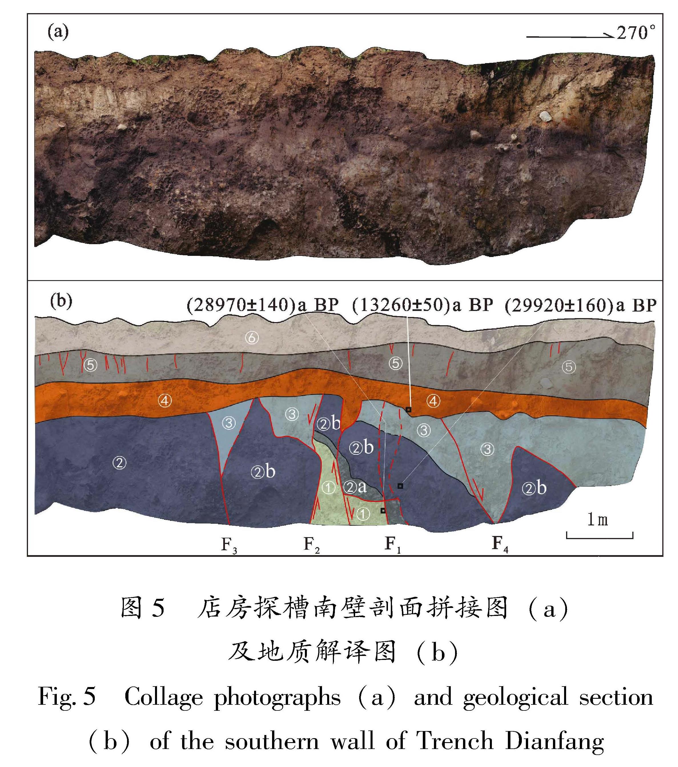
3.2.1 探槽TC1
探槽TC1揭露的主要地层单元特征如下:①褐色黏土与灰绿色砾块互层,顶界具牵引现象,可能为挠曲变形所致; ②黄绿色含黏土砂砾层,发育竖向裂缝,南壁底部洼地处含灰绿色黏土,该灰绿色黏土内采集的14C样品AMS测年结果为距今(10 680±50)a; ③黄绿色含黏土砂砾堆积,含丰富砾块,砾块磨圆度较好,可能为层②的坎前堆积; ④该剖面上未见该层,地层特征见下文TC2地层④描述; ⑤蓝黑色淤泥层; ⑥灰绿色砂砾层,冲积砂砾,磨圆度较好,该层内采集的14C样品AMS测年结果为距今(14 410±40)a; ⑦深褐色黏土层; ⑧表层褐色耕作黏土层,略发红,底界清晰,近水平延伸,该层中部采集的14C样品AMS测年结果为(130.36±0.49)pMC。
探槽TC1剖面上大致可以识别出4组断面:F1、F2、F3和F4(图7),F1和 F2均被层⑧所覆盖,主要发育于较老的层①中,产状陡立。其中,F1已上延至层③中,由数条次级断裂组成(图7)。F3断错层①,可能已延至层⑥中(图7)。探槽剖面也显示,层①顶部普遍存在明显的挠曲变形。
根据断层与沉积地层单元的断错关系,可以识别出一次非常明确的事件,事件发生在层⑥沉积之后、层⑦沉积之前,依据是:F3和F4断错了层⑥、上覆层⑦,由于层⑦未能采到14C样品,事件发生年代只能限定在(14 410±40)a之后。
图7 打挂村探槽TC1北壁剖面拼接图(a)及地质解译图(b)
Fig.7 Collage photographs(a)and geological section(b)of the northern wall of trench Daguacun
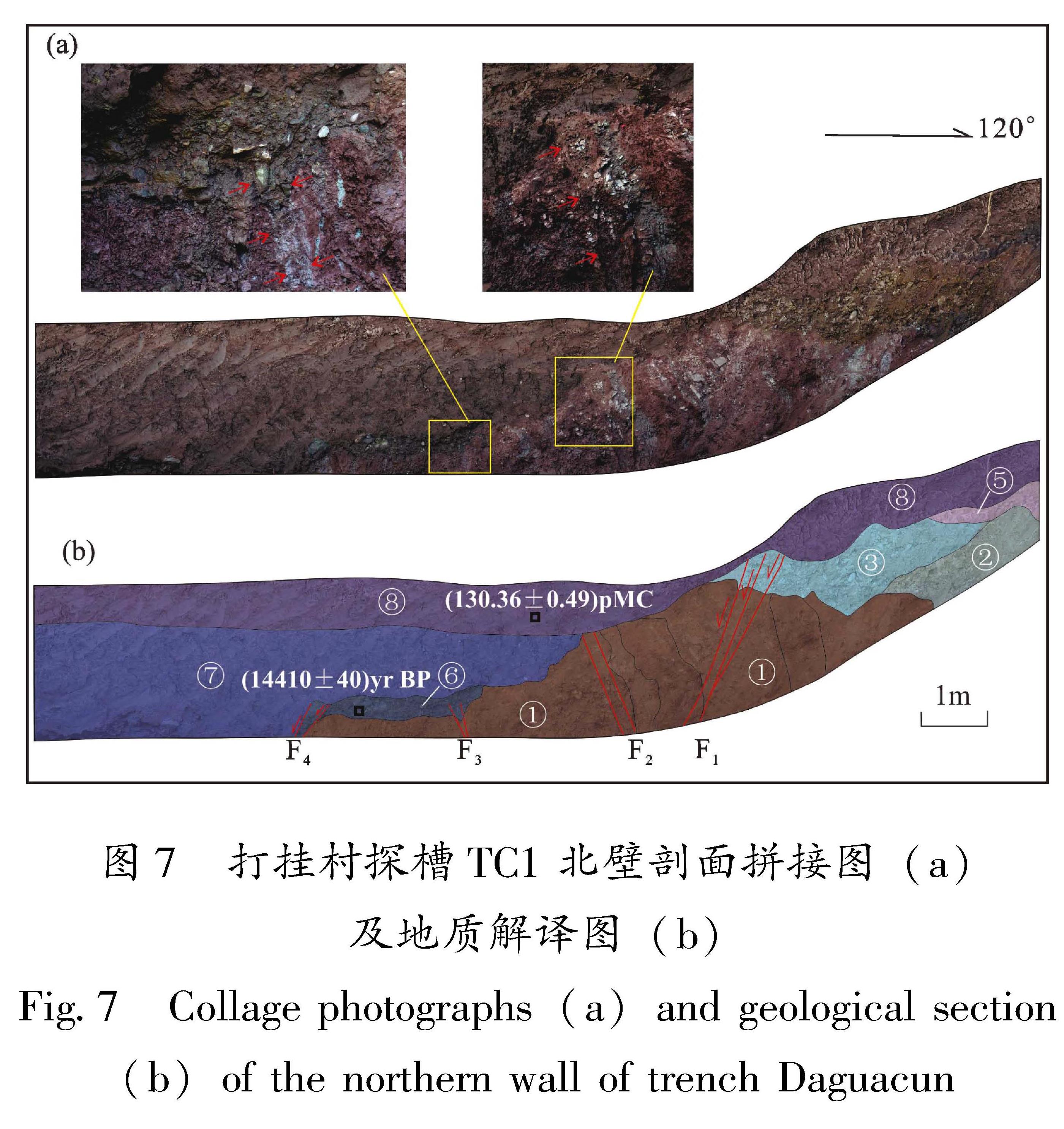
3.2.2 探槽TC2
探槽TC2剖面揭露的主要地层单元特征如下(图8):①风化—半风化的残坡积褐色黏土与灰绿色砾块互层,顶界具挠曲牵引现象; ②团块状土、砾块混杂堆积,整体呈楔状,具坎前或充填楔状堆积特征; ③黄褐色黏土层,与层②不整合接触,界面较清晰,该层顶部采集的14C样品AMS测年结果为距今(2 630±30)a; ④蓝黑色砂砾层,具断陷塘型沉积特点; ⑤蓝黑色粉砂土层,具断陷塘型沉积特点,该层中部采集的14C样品AMS测年结果为距今(2 460±30)a; ⑥黄绿色砂砾层,颜色非常特殊; ⑦包括⑦a、⑦b和⑦c 3个亚层,⑦a为蓝黑色粉砂土和黄绿色砂砾层混杂层,可能为层⑤和层⑥挤压隆起变形形成的鼓包状混杂堆积,⑦b为顺坡堆积的褐色黏土团块,⑦c为近水平堆积的黄褐色砂黏土; ⑧该层底部界限清晰,探槽东侧较厚,根据岩性成分,又可以细分为灰褐色黏土层⑧a、灰土层⑧b、表层耕作土⑧c 3个亚层。
该剖面揭示了两组断裂:F1和F2。其中F1由一系列次级断层组成,具走滑兼有逆冲变形特征; F2发育于洼地沉积的蓝黑色砂砾、粉砂土中,断面不是很清晰。根据断层与沉积层之间的断错关系,探槽剖面揭露出不止一次事件,但限于剖面西段主体为残坡积堆积,缺乏沉积单元和测年样品,故事件序列难以厘定。能够明确的是:最新一次破裂事件沿F2断错了剖面标志层⑤—⑥,沿F1则表现为层⑤—⑥发生了类似挤压鼓包似的鼓起变形,形成层⑦a。根据测年结果,最新一次事件至少发生在(2 460±30)a BP之后。
图8 打挂村探槽TC2南壁剖面拼接图(a)及地质解译图(b)
Fig.8 Collage Photographs(a)and geological section(b)of the southern wall of Trench Daguacun