收稿日期:2021-06-29
基金项目:云南省地震局科技专项(2018ZX02、2021ZX01)资助.
基金项目:云南省地震局科技专项(2018ZX02、2021ZX01)资助.
(Yunnan Earthquake Agency,Kunming 650224,Yunnan,China)
the Yangbi MS6.4 earthquake; seismogenic fault; earthquake risk; earthquake prediction
2021年5月21日21时48分,云南省大理州漾濞县发生MS6.4地震,震中位置(25.67°N,99.87°E)。该地震结束了云南地区自2014年景谷MS6.6地震以来长达6.6年的6级地震平静期,对该地震的深入研究有助于加强对云南地区强震发生机理的认识及对滇西地区后续地震风险进行科学评估。
本次地震发生后,亟需回答两个问题:一是漾濞地区后续较短时间内是否还会有更大地震,即已经发生的强震是否是前震; 二是漾濞地震对周边发震构造的影响以及较长时间内滇西地区的地震趋势是否发生改变。前者也被称为震后趋势判断,重点对地震序列进行跟踪,依据历史地震活动规律(蒋海昆等,2015; 刘珠妹等,2019)、震源力学参数(王生文,2014; 王强等,2015)、G-R关系及其比例系数b值(张帆等,2018; 王光明等,2020; 孟昭彤等,2021; Gulia,Wiemer,2019)、震源机制一致性和频谱特征分析(倪四道等,2010; 刘蒲雄,吕晓健,2012; 郑建常等,2015; 赵小艳等,2015; 向元等,2020)等,跟踪预测近期(数天至3个月)的地震活动趋势。后者研究的空间范围和时间范围更大,一般利用地震前兆异常(付虹等,2020; 李智蓉等,2020)、GPS资料(朱亚戈等,2021)、破裂空段(徐锡伟等,2017)及其它方法(秦四清等,2014; 李培等,2015)。这些研究为我们认识和研究震后趋势及中长期地震危险性提供了可靠的方法和手段。本文利用漾濞及周边地区的活动断裂、地球物理和地震前兆等资料进行综合研究,探讨了漾濞MS6.4地震的发震断裂,对漾濞地震震中周边地区的地震危险性进行了分析。
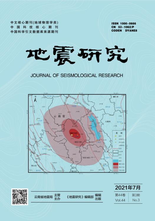
云南地处青藏高原东南缘,印度板块与欧亚板块碰撞的侧翼。印欧板块的碰撞形成雄伟的喜马拉雅山脉,同时下地壳及地幔物质沿喜马拉雅东构造结顺时针侧向挤出,进入到川滇菱形块体内。漾濞地震震中位于川滇菱形块体西南缘附近,是青藏高原物质向东南挤出的通道(吴中海等,2015),属于挤出变形最强烈的区域,周边100 km范围内发育有红河断裂、丽江—小金河断裂、鹤庆—洱源断裂、程海—宾川断裂和龙蟠—乔后断裂5条全新世活动断裂(安晓文等,2018)(图1)。红河断裂全长超过1 000 km,是喜马拉雅—西藏碰撞带中一条重要的走滑断裂(Tapponnier et al,1990; 张培震等,2003,2004; Xuan et al,2018),历史上曾发生过2次7级以上地震、7次6.0~6.9级地震,是云南省内活动程度最高的断裂之一,其长期平均滑动速率为2~5 mm/a(Allen et al,1984; Replumaz et al,2001; Schoenbohm et al,2006; 陈静,2013)。丽江—小金河断裂是青藏高原东南缘地貌的分界线,有可能是龙门山断裂带西南方向的延伸,且可能与中下地壳流有关(Burchfiel,Chen,2013; 徐锡伟等,2003; 许志琴等,2007),虽然该断裂上未记录到7级以上历史地震,但其重要性不容忽视。以往研究通过地貌测量、年代学测试、GPS等方法得到丽江—小金河断裂的左旋走滑速率为3.0~5.0 mm/a(郜宇等,2019; 向宏发等,2002; 徐锡伟等,2003;
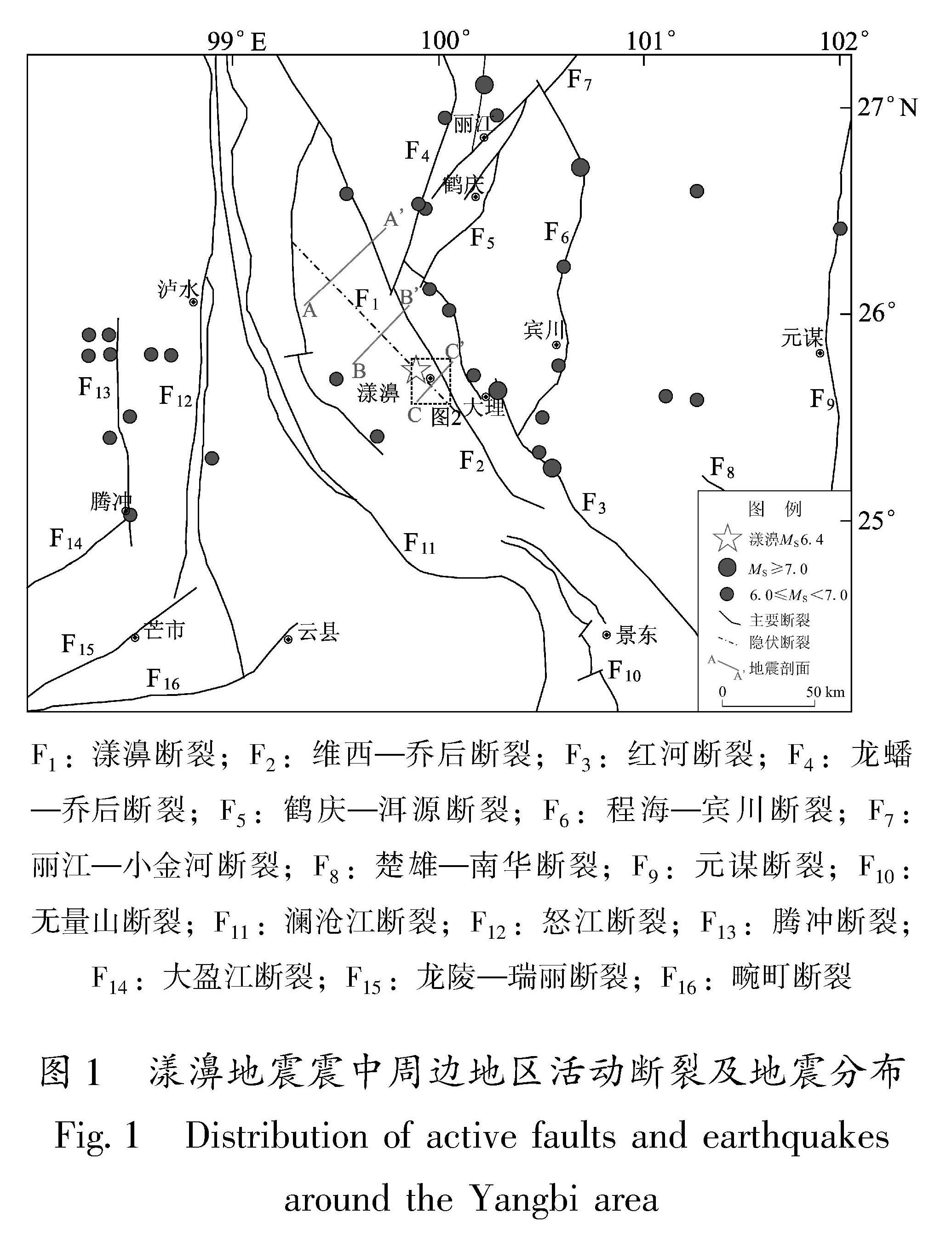
图1 漾濞地震震中周边地区活动断裂及地震分布
Fig.1 Distribution of active faults and earthquakes around the Yangbi area
程佳等,2012; Rui,Stamps,2016); 鹤庆—洱源断裂走滑速率为1.8~2.0 mm/a(Sun et al,2017; 魏永明等,2017); 程海—宾川断裂曾发生过1515年73/4级大地震,滑动速率约为0.2~1.4 mm/a(黄小巾等,2018; 国家地震局地质研究所,1990; 俞维贤等,2005); 龙蟠—乔后断裂水平滑动速率高达3.10~6.45 mm/a(汤勇,2014)。
自1515年以来,漾濞地震震中周边150 km范围内共记录到4次7级以上地震,分别是:1515年永胜73/4级地震、1652年弥渡7.0级地震、1925年大理7.0级地震和1996年丽江7.0级地震。该区6级以上地震较发育,大多分布在活动断裂上,如红河断裂、程海—宾川断裂、腾冲断裂等。该区域7级地震记录较少的原因可能是云南属于边陲地区,人口稀疏,有地方志等历史记录的时代也较短,可能发生漏记现象或震级判断不准等,例如丽江—小金河断裂上探槽揭露出距今479 a的古地震(国家地震局地质研究所,1990),鹤庆—洱源断裂上探槽揭露出距今290~800 a的古地震(Sun et al,2017),均未发现有历史记载。
漾濞MS6.4地震震中距离维西—乔后断裂约11.5 km。该断裂北起于维西县以北,向南东经马登、乔后、长邑、漾濞,止于巍山盆地南,全长约280 km,总体走向NW,倾向SW或NE。维西—乔后断裂1:50 000活断层填图资料及野外调查情况显示,该断裂的主干断裂在漾濞附近,主要展布在县城以东的上邑村、桑不老、紫阳村、何家庄、蒙光村一带,穿越的水系同步右旋位错,5条河流分别位错1.5、0.9、1.2、1.1和1.8 km(图2)。上邑村以北至长邑段断层地貌不明显。以长邑为界,其以北在卫星影像上具有清晰的线性特征,发育有大量水系同步位错、断层三角面、线性槽谷等活动断层地貌,并且沿线串珠状发育有维西、通甸、上兰、马登等多个断陷盆地(常祖峰等,2016c); 长邑以南的线性特征及活动断层地貌较弱。该断裂早期以挤压逆冲为主、晚更新世以来则以右旋走滑为主,张性正断为辅,是一条晚更新世活动断裂(任俊杰等,2007; 常祖
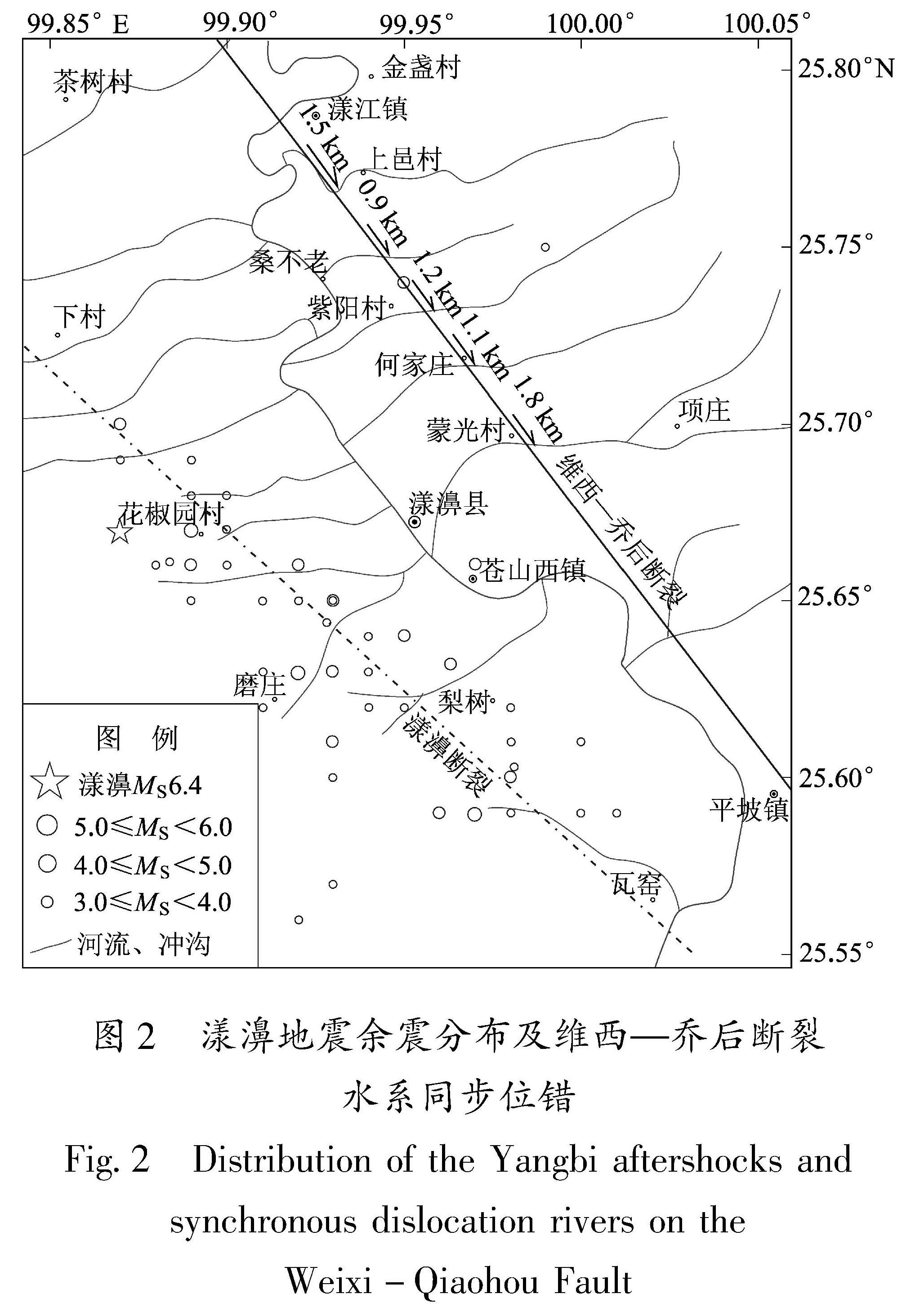
图2 漾濞地震余震分布及维西—乔后断裂水系同步位错
Fig.2 Distribution of the Yangbi aftershocks and synchronous dislocation rivers on the Weixi-Qiaohou Fault
峰等,2014,2016a,b; 汤沛,2013)。云南地区7级以上地震绝大多数均发生在全新世活动断裂上,例如1996年丽江7.0级地震发生在丽江—大具断裂上(王运生等,2000),1988年澜沧7.4、7.2级地震发生在龙陵—澜沧断裂上(刘兴旺等,2016; 邵延秀等,2015),1970年通海7.8级地震发生在曲江断裂上(Wang et al,2014; 王洋等,
2015)等。自云南省有历史地震记录以来,省内20余条晚更新世活动断裂均未记录到7级以上地震,说明云南省晚更新世活动断裂的强震复发周期长,如维西—乔后断裂上发生的最大地震为1948年61/4级地震(常祖峰等,2014),楚雄—建水断裂上发生的最大地震为1680年的63/4级地震(常祖峰等,2015),畹町断裂上发生的最大地震为1976年6.0级地震(戴雨芡等,2017)。如果本次漾濞MS6.4地震的发震断裂为晚更新世活动的维西—乔后断裂或其分支断裂,则发震断裂上短期内发生更大地震的可能性较小。
地震发震断裂的确定对后续强震风险评估有重要作用。对于地震发震断裂的判定,一般是先根据震源机制解和余震精定位进行初判,再由野外调查进行对比分析与复判。震源机制解方面,本文采用CAP方法(Zhao,Helmberger,1994; Zhu,Helmberger,1996)反演了主震的震源机制解,与USGS https://earthquake.usgs.gov/earthquakes/eventpage/us7000e532/moment-tensor.(美国地质调查局)、ISC http://www.isc.ac.uk/iscbulletin/search/bulletin.(国际地震中心)、GFZ http://geofon.gfz-potsdam.de/eqinfo/event.php?id=gfz2021jwvt.(GFZ-GEOFON数据中心)等给出的节面走向及倾角一致性较好,分别介于315°~319°和81°~89°,平均为317°和85°(图3)。余震精定位方面,余震分布的优势方位为314°左右,主震后1天内余震的倾角约为85°(姜金钟等,2021)。而维西—乔后断裂的走向为340°左右,倾向SW或NE,倾角50°~75°左右(常祖峰等,2014,2016c)。维西—乔后断裂走向与震源机制解和余震精定位结果并不一致,存在20°~25°左右的夹角。同时,精定位给出的震中位置(姜
图3 漾濞地震震源机制解
Fig.3 Focal mechanism solutions of the Yangbi earthquake
金钟等,2021)距离维西—乔后断裂较远,超出了震中位置与发震断层间距的合理值,可以初步认为发震断裂不是维西—乔后断裂的主断裂。地震后对震中附近进行了初步野外调查,发现震中附近基岩中发育有一些走向为340°左右的小规模断层,断层的延续性一般,穿越了多条冲沟和山脊,但未发现冲沟、山脊、洪积扇等地貌单元存在错动现象。中国地震局科考组在震中附近发现了走向为310°左右的地表裂缝,沿罗旮么、阿歇厂、华家庄一带展布,沿该地表裂缝方向追索,未发现有冲沟位错、阶地位错等显著的活动构造地貌发育,初步认为发震断裂不是类似于包谷垴—小河断裂(李西等,2018)的先存活断裂,而可能是新生隐伏断裂。对发震断裂性质的准确判定还需要更进一步的详细调查。
王志伟(2020)利用洱源及周边架设的台间距约为15~20 km的流动台站数据,使用模板匹配的方法检测出11 130个地震事件。这些地震沿维西—乔后断裂分布的并不多,主要分布在断裂东、西两侧。东侧的地震主要受鹤庆—洱源等活动断裂控制,而西侧的地震主要丛集于一个NW向的条带,其中北端距维西—乔后断裂约30 km,南端在漾濞以南交汇于维西—乔后断裂上,本文称这条NW向断裂为“漾濞断裂”(图1中虚线所示)。自北向南横跨漾濞断裂、维西—乔后断裂的3个剖面(断层位置及剖面位置见图1)显示,漾濞断裂具有高倾角、倾向SW的特点,并且往南逐渐靠近维西—乔后断裂(图4)。2019年11月25日在漾濞断裂中部发生的4.4级地震的震源机制解节面I走向为310°、滑动角为165°,与本次漾濞地震的震源机制解参数较为接近。综合分析认为漾濞断裂可能是漾濞地震的发震断裂。
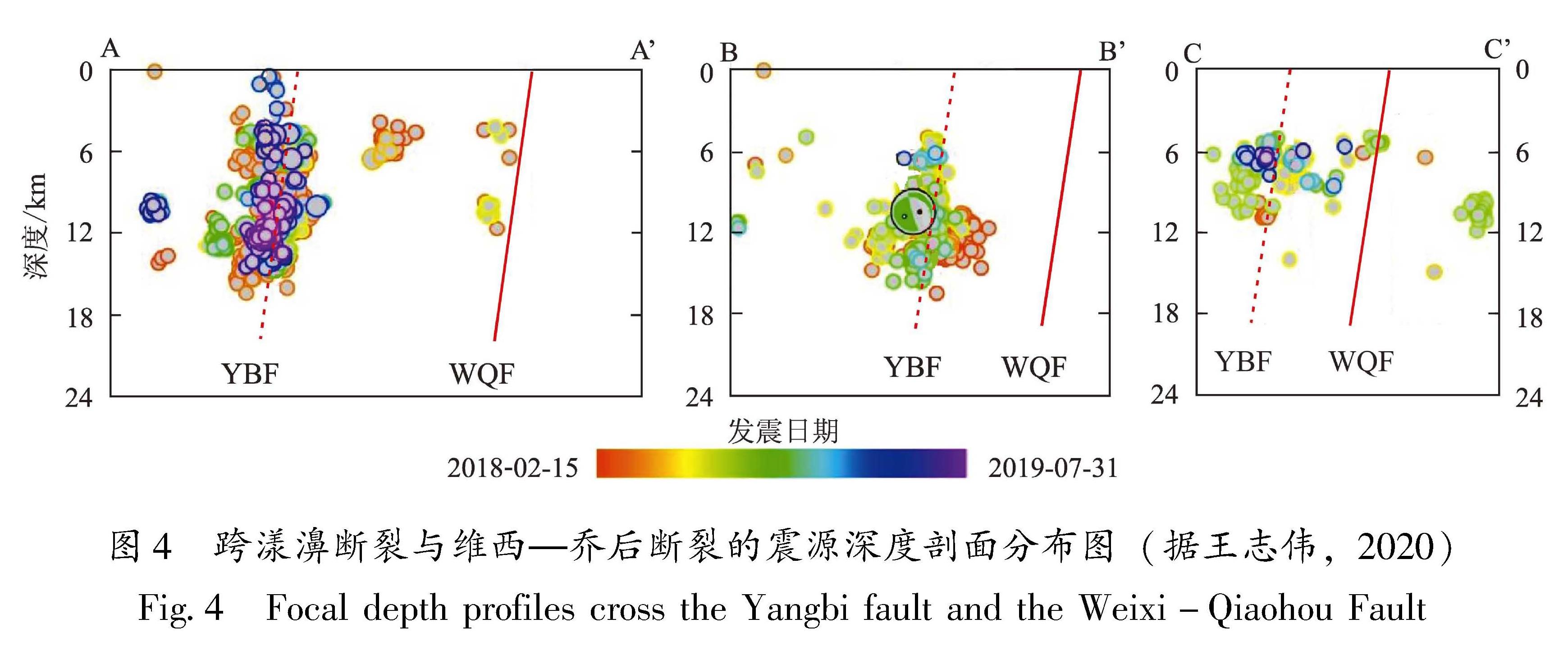
图4 跨漾濞断裂与维西—乔后断裂的震源深度剖面分布图(据王志伟,2020)
Fig.4 Focal depth profiles cross the Yangbi fault and the Weixi-Qiaohou Fault
大地震,尤其是7级以上地震的空间展布具有一定的规律性。邓起东等(2003)对中国大陆6级以上地震与活动构造带关系进行了研究,发现所有的8级以上及绝大多数7~7.9级地震都发生在活动块体边界断裂及活动断裂、活动褶皱和活动盆地内,其他学者也给出了相似的结果(张培震等,2003; 张国民等,2004,2005)。云南省22次7级以上地震,除1976年龙陵7.4级地震外,其它均发生在已知的全新世强烈活动断裂上。漾濞断裂不属于活动块体边界断裂,活动性也不强,不符合徐锡伟等(2017)述及的几种高震级地震的地质学标志,因此该断裂上发生7级以上地震的可能性较小。
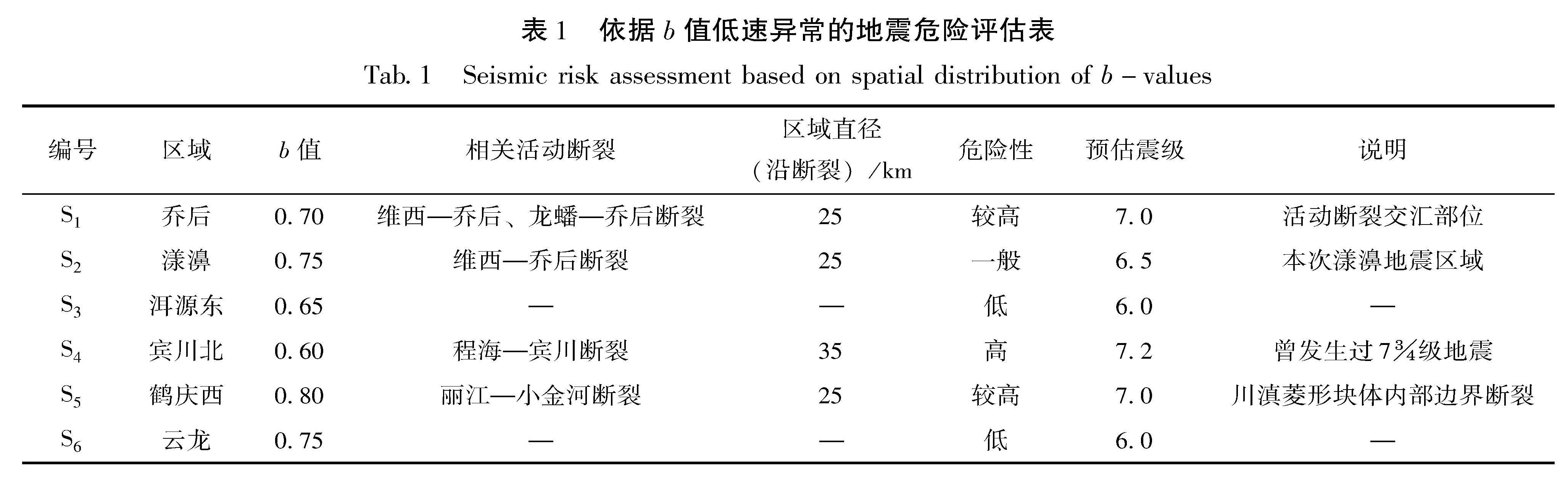
断裂地表滑动速率是刻画断裂活动程度及危险性的重要指标(邓起东,闻学泽,2008; 张培震等,2008),例如云南地区活动程度最高的小江断裂左旋走滑速率达到了10 mm/a(宋方敏等,1998; Wang et al,1998; 王阎昭等,2008; 韩竹军等,2017)。云南地区的全新世活动断裂普遍具有7级地震的构造条件,但因滑动速率不同,强震的复发周期也不相同。从滑动速率分析,龙蟠—乔后断裂具有更高的地震风险,丽江—小金河断裂次之。从强震离逝时间分析,红河断裂的强震离逝时间约为100 a(虢顺民等,1984),程海—宾川断裂(俞维贤等,2005; 王亚磊,2018)、鹤庆—洱源断裂(Sun et al,2017)的强震离逝时间约为500 a,丽江—小金河断裂的强震离逝时间约为1 600~1 900 a(丁锐等,2018),龙蟠—乔后断裂上未揭露出距今5 000 a以内的古地震(汤勇等,2014)。综合分析认为,龙蟠—乔后断裂具有较高的风险,丽江—小金河断裂次之。
地震波是照亮地下的一盏明灯。利用布设于地表的地震仪接收不同深度、不同位置、不同来源的地震波,通过不同的方法,得到地壳介质的状态参数及其随时间的变化特征。再将已发生的地震与这些特征进行对比,得到地壳介质状态与地震发生之间的关系。
震级-频度关系中的b值表征了不同震级地震数所占的比例(Rundle,1989)。不同学者对b值的物理意义及发生机制有不同的理解(李纪汉,1987; Wiemer et al,1997,1998; Schorlemmer,Wiemer,2005),但普遍认为b值与应力变化以及介质的不均匀性有关,因此其随时间变化特征可以用来预测未来大地震的发生,其空间变化特征可以用来判别强震危险区(张帆等,2018; 孟昭彤等,2021)。较多的学者在云南地区开展过b值研究,认为低b值异常可以用于未来强震发生位置的判定(付虹等,2020; 王光明等,2020; 刘自凤等,2019; 邵延秀等,2015),但因为使用台站间距较大,数据空间分辨率较低,一般只能进行较大空间范围的预测。
王志伟(2020)利用高密度台站的数据研究了丽江—洱源—漾濞区域b值随时间变化特征及空间展布,共划分了6个低b值区域(图5)。结合该区的活动断裂分布,我们对这6个低b值区域的危险性进行了评估(表1),认为宾川北(S4)、乔后(S1)和鹤庆西(S5)具有较高的地震风险。
F1:维西—乔后断裂; F2:兰坪—云龙断裂; F3:澜沧江断裂;
F4:龙蟠—乔后断裂; F5:丽江—小金河断裂; F6:鹤庆—
洱源断裂; F7:程海—宾川断裂; F8:红河断裂;
S1~S6:低b值区域,名称见表1
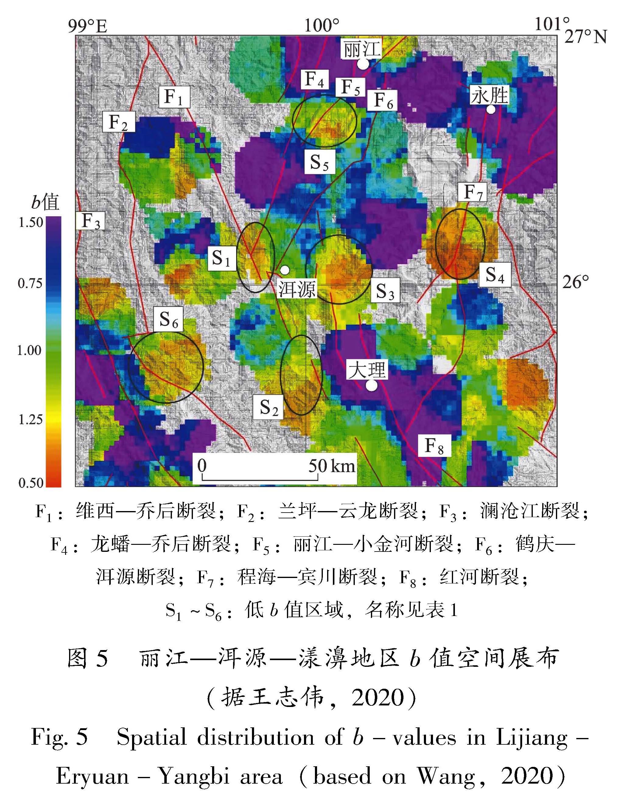
图5 丽江—洱源—漾濞地区b值空间展布(据王志伟,2020)
Fig.5 Spatial distribution of b-values in Lijiang-Eryuan-Yangbi area(based on Wang,2020)
表1 依据b值低速异常的地震危险评估表
Tab.1 Seismic risk assessment based on spatial distribution of b-values
地壳介质具有横向不均匀性,P波高速异常表明介质具有相对较高的强度,有利于能量的积累,一定程度上能阻挡断层破裂的传播(吴建平等,2009; 李大虎等,2015; 刘白云等,2018)。云南地区大部分的历史大震都分布在高、低速介质交界的位置(刘毅,2020),这和Huang和Zhao(2004)在华北地区对唐山7.8级地震和三河8级地震的研究成果一致。
刘毅(2020)利用喜马拉雅计划Ⅰ期的数据,采用双差层析成像的方法得到了洱源及滇西北地区三维P波速度结构模型,从漾濞往NW和NE向绘制了两条P波速度剖面(图6)。从图6中可以得到以下初步结论:①此次漾濞地震发生在P波低速区域,被其南北两侧的高、低速区域阻挡并限制在14 km范围内(与震源反演出的破裂范围一致),这可能是本次地震震级未超过6.5级的原因; ②在25.9°N以南的中上地壳内(7~25 km范围内)发育有大面积的低速区域,同时,15 km深度与25.40°N、25.57°N、25.80°N交汇区域发育的多个低速体,表明该区域NW向的主体断裂(维西—乔后断裂,漾濞断裂等)可能被NE向的断裂横向切错,形成尺度较小(~10 km)的相对高速-低速相互间隔的块体,这样的结构不利于应力的积累以及在地震过程中破裂的传播; ③25.9°N以北的中上地壳(7~25 km范围内)内为连续高速结构,高速结构下方发育有低速结构,这样的结构形式容易引起上地壳的应力积累,有利于大地震的孕育和发生。25.9°N以北区域包含了S1乔后风险区,延伸长度约为100 km,估算其发震能力约为7.3级(Cheng et al,2020)。其它断裂沿线也有P波高速异常展布(刘毅,2020),但沿断裂长度一般较为有限,异常幅度也较低。
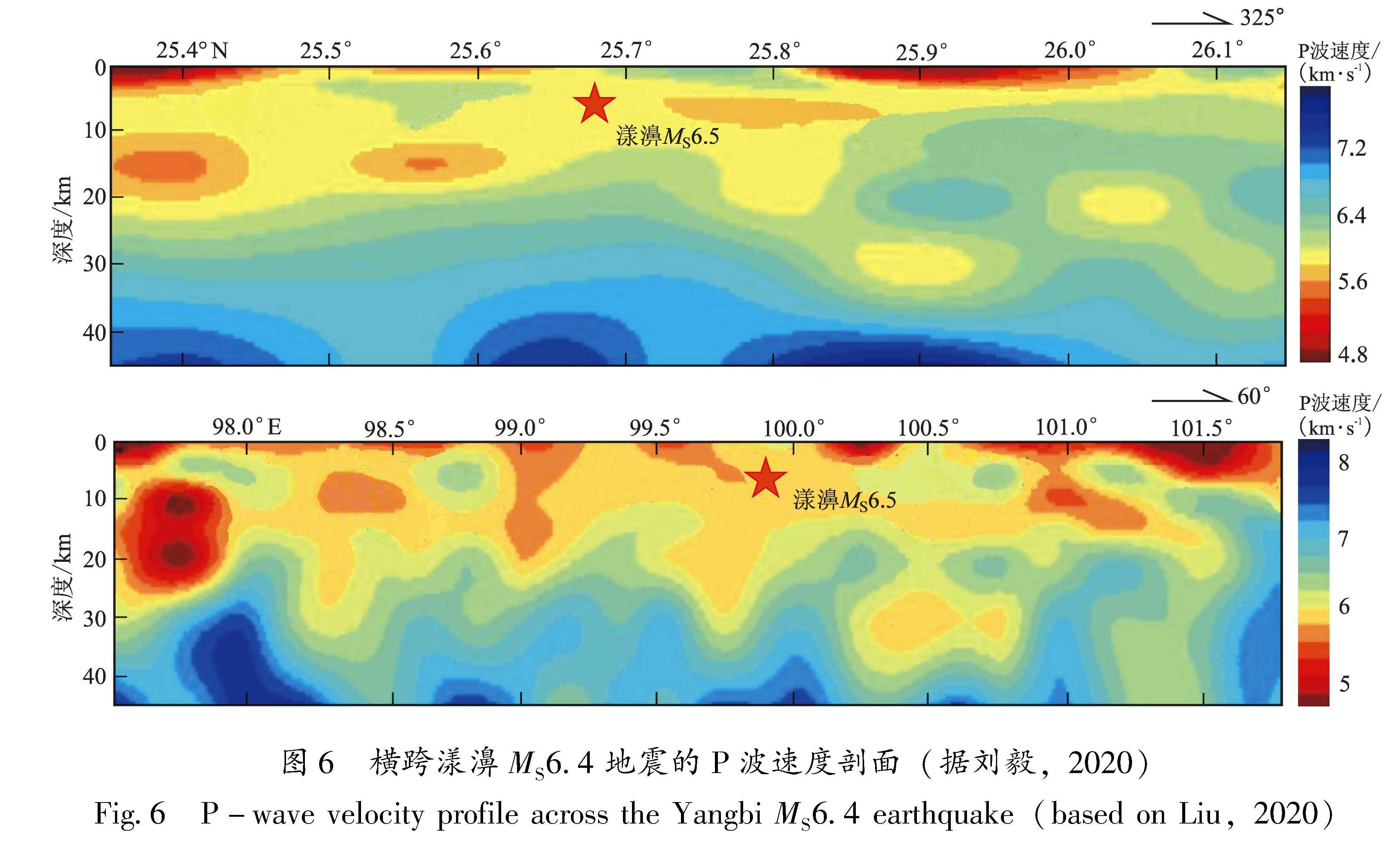
图6 横跨漾濞MS6.4地震的P波速度剖面(据刘毅,2020)
Fig.6 P-wave velocity profile across the Yangbi MS6.4 earthquake(based on Liu,2020)
利用重复地震估算断裂深部滑动速率是评估断裂风险的有效手段(Nadeau,McEvilly,1999; Igarashi et al,2003; Turner et al,2013),近年来国内及省内开展了利用重复地震估算深部滑动速率的工作(李乐等,2013,2015; Li et al,2007,2011),得到鹤庆—洱源断裂的滑动速率为2.3~2.9 mm/a,程海断裂的滑动速率为2.0~2.6 mm/a,红河断裂的滑动速率为3.9~4.9 mm/a,维西—乔后断裂与龙蟠—乔后断裂交汇区域(乔后)的滑动速率为5.4~8.0 mm/a(孙庆山,2018; 孙庆山,李乐,2020),丽江—小金河断裂的滑动速率为4.3~5.4 mm/a(李乐等,2008)。从断裂深部滑动速率可以看出,位于龙蟠—乔后断裂和维西—乔后断裂交汇部位的乔后镇具有最高的滑动速率,丽江—小金河断裂西南段次之,因此认为乔后区域、鹤庆西区域具有较高的地震风险。
2014年云南盈江县发生了MS6.1地震,根据地震序列精定位、发震构造等方面的研究(张艳凤等,2018; 杨婷等,2016; 黄小龙等,2015),发现这组地震与本次漾濞地震具有较多的共同点:
(1)两次地震震中均位于滇西南活动块体内。云南地处青藏高原东南缘,以红河断裂和小江断裂为界,可以划分为3个活动块体。盈江地震及漾濞地震均发生在滇西南活动块体内(张国民等,2005; 邓起东等,2009),该块体被红河断裂及实皆断裂围限,内部以北东向主压应力为主,在水平向主压应力和主张应力作用下,区内断裂易发生走滑运动。这两次地震均为走滑型地震。
(2)两次地震均发生在活动性不显著的次级断裂上。盈江地震发生在卡场—大竹寨断裂上(杨婷等,2016),漾濞地震发生在漾濞断裂上,这两条断裂上在震前均未记录到5.5级以上地震。卡场—大竹寨断裂走向为NNW向,全长约110 km,断裂活动性不显著,遥感影像上无明显线性迹象,野外调查也未发现有明显的活动构造地貌发育。漾濞断裂走向为NW向,全长约130 km,根据遥感影像解译及野外调查,其活动性不强于卡场—大竹寨断裂,并且线性特征及活动性均弱于滇西南活动块体内的其它活动断裂。
(3)卡场—大竹寨断裂附近发育有大盈江断裂和苏典断裂(黄小龙等,2015),漾濞断裂附近发育有红河断裂和维西—乔后断裂,这些断裂的走向、倾向等都与发震断裂相近,并且具有更高的活动性。当区域地壳应力增加时,强震并未发生在活动性更强的晚更新世活动断裂(苏典断裂,维西—乔后断裂)及全新世活动断裂(大盈江断裂、红河断裂)上,其原因是块体内部老断裂的复活和新断裂的产生,还是活动断裂的进一步闭锁,有待于进一步研究。
(4)两次地震前震源区均发生较强地震。盈江MS6.1地震前震中附近曾发生过MS5.6地震,漾濞MS6.4地震前震中附近也发生过MS5.6地震。
两次地震具有相似的构造背景、相近的断层规模与活动特征,并且主震前震中附近均发生了较强地震,因此在评估后续地震危险时可以进行对比和参考。自2014年盈江6.1级地震至今,盈江地震的发震断裂未再发生6级以上的强震,据此推测,本次漾濞地震后几年内原震区发生6级以上地震的可能性较小。
观测事实证明,震前的地壳变形可能会导致形变、流体等测项出现异常,这些异常主要反映场兆信息(付虹等,2020)。由于目前云南的定点观测前兆台站密度仍然不够高,前兆台站的位置不一定位于断裂上或上盘不远处等应力应变易于积累的部位,因此前兆数据主要用于较大范围内的地震预测。本次漾濞地震震中50 km范围内共有4个前兆台站,其中洱源水化站(震中距50 km)水温数据对此次地震的同震响应及震后恢复趋势与2017年漾濞5.1级地震相似(图7)。初步认为短期内强震原地复发的可能性较小。漾濞MS6.4地震后,川滇菱形块体西南边界大多数定点形变、跨断层等显著异常状态仍在持续或未发生趋势性改变,分析认为整体上滇西及云南地区地震高风险未因漾濞地震的发生而解除。
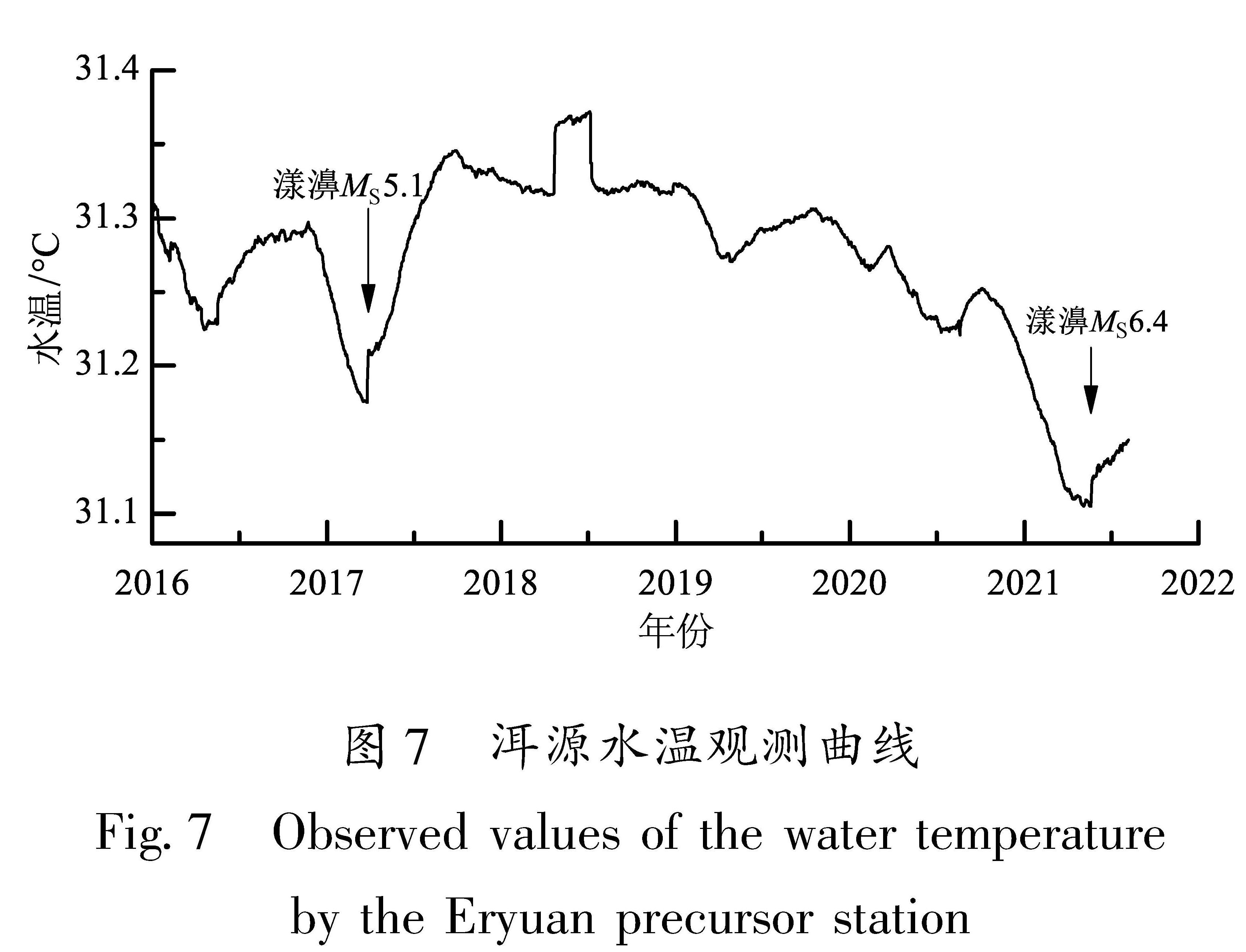
图7 洱源水温观测曲线
Fig.7 Observed values of the water temperature by the Eryuan precursor station
已有学者对维西-乔后断裂的最新活动时代、运动性质等方面开展了详细的研究,该断裂在晚更新世甚至全新世有明显的活动迹象,运动性质以右旋走滑兼正断为主(任俊杰等,2007;常祖峰等,2014,2016a, b;汤沛,2013 )。从地貌、运动方式、P波速度等方面可以粗略地将维西—乔后断裂以长邑为界分为两部分,长邑以北为维西—乔后断裂北段,以南为维西—乔后断裂南段。北段地貌上断裂行迹明显,与龙蟠—乔后断裂相当,南段则不明显; 北段以正断为主(震源机制解,半地堑盆地发育),南段以右旋走滑为主(水系同步右旋位错); 北段中上地壳P波速度以高速为主,南段以相对低速为主; 北段单独成为川滇菱形块体边界,南段与红河断裂一起成为川滇菱形块体边界。可以看出,北段明显具有更强的活动性,虽然历史上北段最大地震仅61/4级,但从构造类比的角度推测北段具有发生7级以上地震的能力; 南段历史上未记录到6级以上地震,推测其最高发震能力为6.5级。
本文得出漾濞地震的发震断裂不是维西—乔后断裂的主断裂,而是NW向的漾濞断裂,通过卫星影像解译及在漾濞以西的野外调查初步认为该断裂是一条新生断裂。但卫星影像解译具有其局限性(李西等,2018),未来对该断裂开展全面的地质与地球物理调查,确定其活动时代、空间展布等对于评估该断裂的潜在发震能力及该地区中长期地震风险具有重要意义。
活动断裂和地球物理方面的研究都可以用于地震预测。先通过地貌、古地震、年代学测试等方法确定活动断裂的强震复发周期、滑动速率、强震离逝时间等,并由此得到不同断裂、断裂不同段危险性结果的研究方法,主要用于中长期地震预测及背景性地震危险性分析。在中长期预测的基础上,通过地球物理方面的研究,可更进一步确定地震风险区域。从不同的研究方向分析,漾濞震中附近的5条全新世活动断裂具有不同级别的危险性:从断裂地表滑动速率角度,危险性由大到小分别为龙蟠—乔后断裂、丽江—小金河断裂、红河断裂、鹤庆—洱源断裂、程海—宾川断裂; 从b值空间分布来看,程海—宾川断裂中段、龙蟠—乔后断裂南段、丽江—小金河断裂南段具有较高的地震风险; 从中上地壳(10 km)P波速度分布来看(刘毅,2020),高速体大范围显著分布的分别为丽江—小金河断裂、龙蟠—乔后断裂、程海—宾川断裂、红河断裂、鹤庆—洱源断裂; 从深部滑动速率的角度,从大到小依次为龙蟠—乔后断裂、丽江—小金河断裂、红河断裂、鹤庆—洱源断裂、程海—宾川断裂。将每一项指标的危险性进行等级划分,以0~4表示,数值越高,表示发震危险性越大。计算得到5条断裂的综合危险性(表2)。从表2可以看出,龙蟠—乔后断裂和丽江—小金河断裂的危险性最高。结合沿断裂b值分布及P波高速异常分布,认为乔后地区及鹤庆西地区具有较高的地震风险(图8)。
表2 漾濞地震震中周边地区5条全新世活动断裂地震危险性等级评估
Tab.2 Seismic risk assessment of 5 Holocene active faults around the Yangbi earthquake
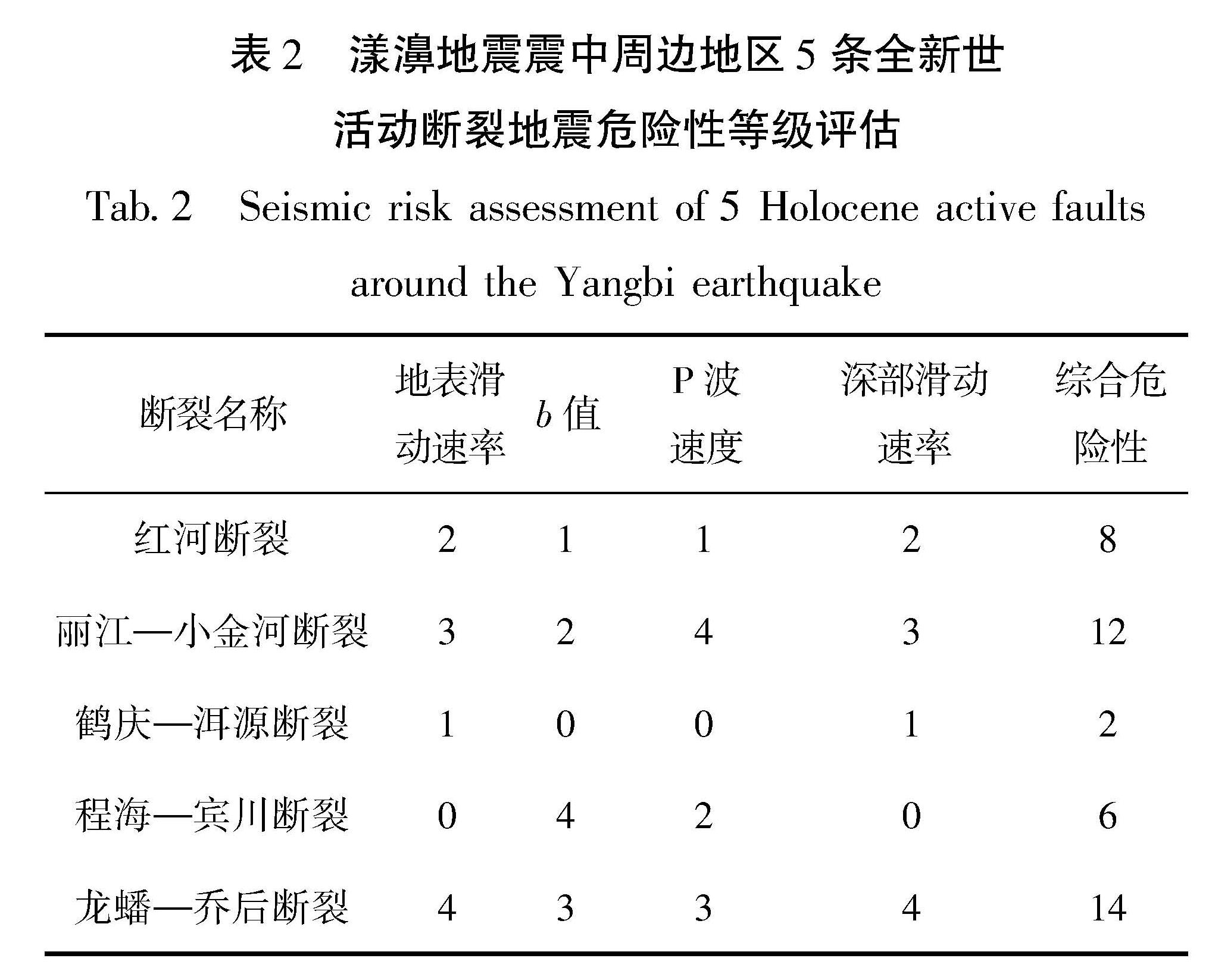
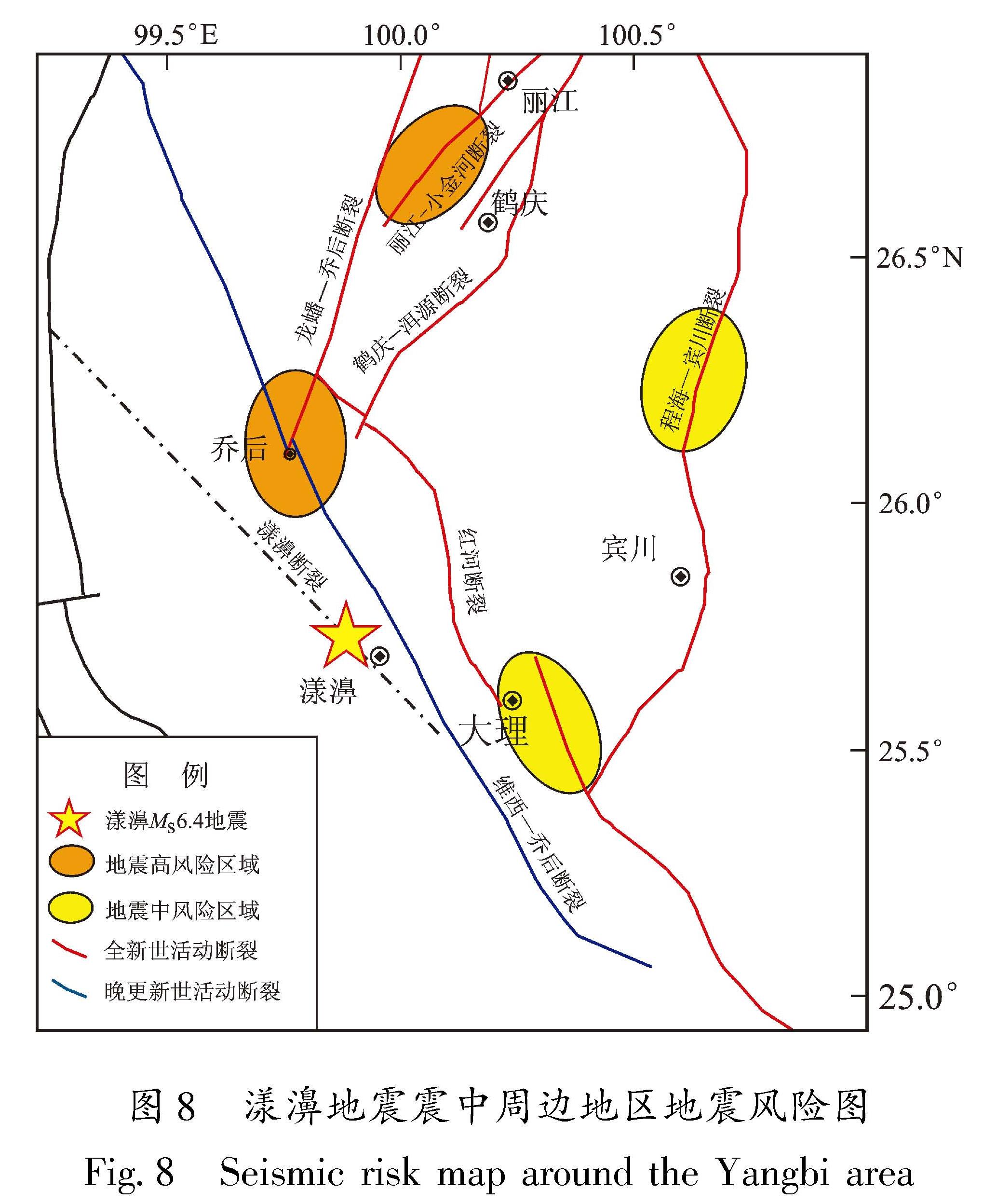
图8 漾濞地震震中周边地区地震风险图
Fig.8 Seismic risk map around the Yangbi area
本文综合分析了漾濞地震震中周边地区活动断裂及地球物理方面的资料,确定了2021年漾濞MS6.4地震的发震断层,分析了漾濞地震震中及周边地区的地震危险性,得到如下结论:
(1)维西—乔后断裂是一条晚更新世活动断裂,以长邑为界,南段活动性弱于北段。
(2)漾濞地震的发震断裂可能是一条NW向的隐伏断裂,该断裂的活动性、危险性等有待于进一步研究。
(3)根据震中附近活动构造、地球物理、历史震例及前兆数据等资料,认为漾濞地震原震区发生更大震级地震的可能性较低。
(4)乔后镇及附近区域(龙蟠—乔后断裂南端)、鹤庆西区域(丽江—小金河断裂南西段)具有较高的地震风险,未来几年内应重点关注这两个区域。