基金项目:地震科技星火计划(XH21036Y)、青海省重点研发与转化计划资助项目(2021-SF-151)和青海省地震局地震科学基金(2021A02)联合资助.
(1.青海省地震局,青海 西宁810001; 2.青海省应急管理厅信息中心,青海 西宁810001)
(1.Qinghai Earthquake Agency,Xining 810001,Qinghai,China;2.Emergency Management Department of Qinghai Province,Xining 810001,Qinghai,China)
the Xiahe earthquake; CAP method; focal depth; time-reversal imaging technique
备注
基金项目:地震科技星火计划(XH21036Y)、青海省重点研发与转化计划资助项目(2021-SF-151)和青海省地震局地震科学基金(2021A02)联合资助.
引言
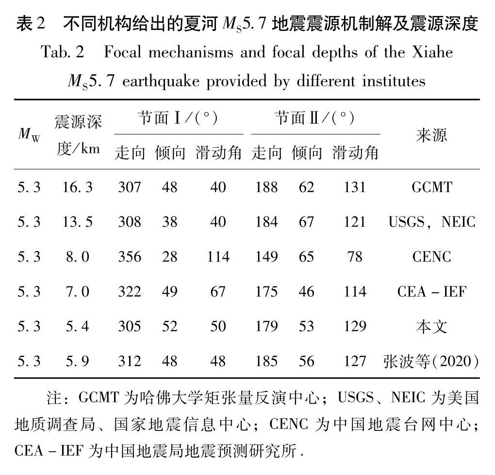
2019年10月28日,甘肃省甘南藏族自治州夏河县(102.69° E,35.10° N)发生MS5.7地震,震源深度10 km。本次地震发生在构造特征复杂的甘东南地区,没有造成严重的人员伤亡,受伤人员均属避震不当造成的轻微擦伤。地震发生后,美国地质调查局(USGS)给出的震源深度为13.5 km,全球矩心矩张量研究中心给出的震源深度为16.3 km,而国内研究机构利用CAP方法反演得到的震源深度为7 km 或8 km。获得准确的震源深度对于探明夏河MS5.7地震的发震构造机制具有重要意义,而各机构给出的震源深度存在显著差异,因此需要进一步测定更加精确的结果。
基于宽频带波形记录的CAP方法(Zhao,Helmberger,1994,1996),可通过对Pnl波和面波分别赋予不同的权重值和时间移动以降低对速度模型的依赖性,还可以利用更大方位角覆盖范围内记录的S 波或面波信息以增加震源深度测定的可靠性,故CAP方法在精确测定震源深度等相关研究中被广泛应用(吕坚等,2008; 韦生吉等,2009; 曾祥方等,2013; 赵韬等,2019; Jiang et al,2019; Lei et al,2019)。逆时成像技术是一种非线性反演技术,基于较好的观测台网和合理的速度模型在人工地震(许力生等,2013b)、2016年青海门源6.4级地震(黄浩等,2017)和2014年云南鲁甸6.5级地震(魏强等,2017)精确定位中已展现出优势。
为深入研究甘肃夏河及邻区的孕震机理和地震活动性,本文搜集了青海、四川和甘肃地震台网的波形资料,利用CAP方法反演了夏河MS5.7地震的震源机制解和最佳震源矩心深度,利用逆时成像技术获得了夏河MS5.7地震的震源深度。
1 地质构造背景
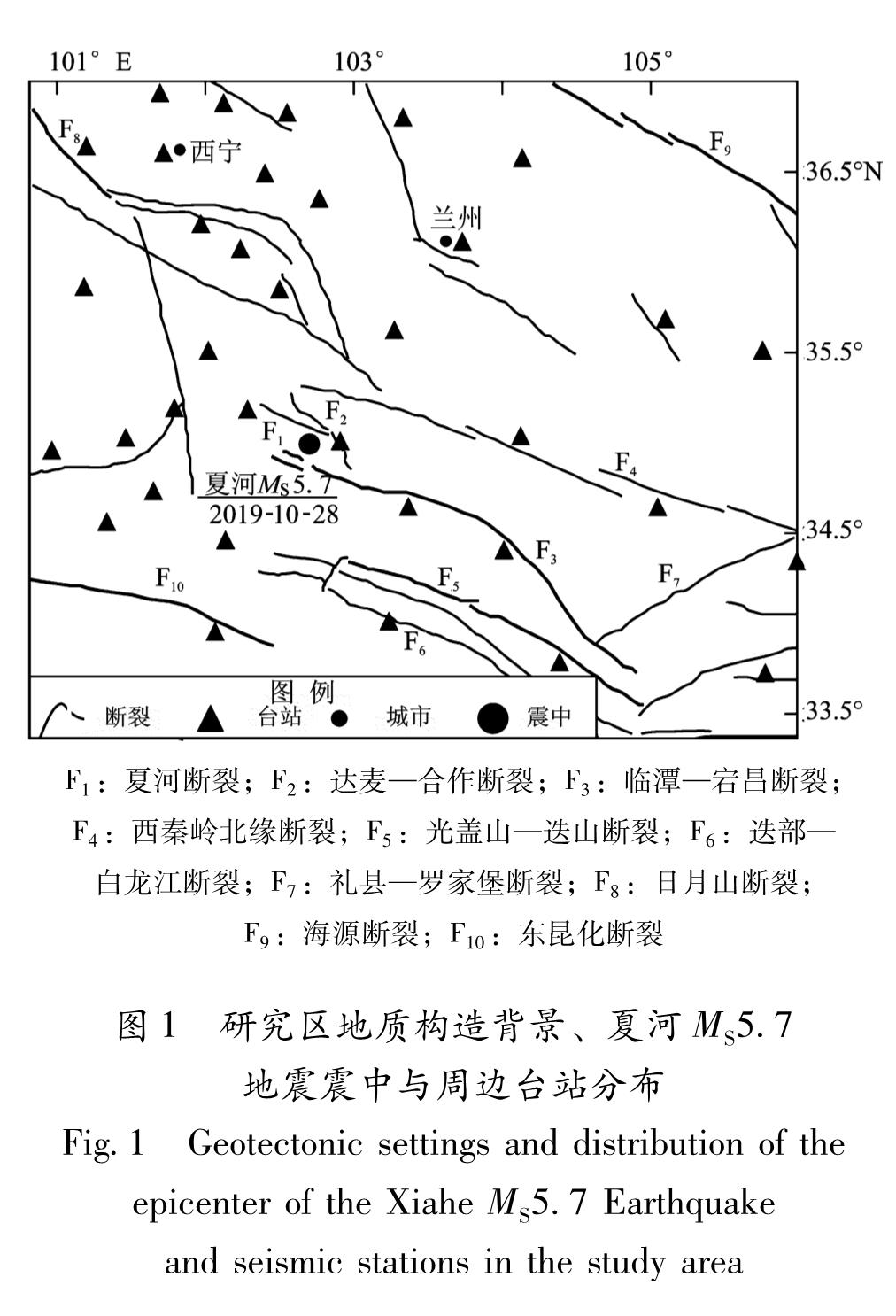
甘东南地区位于两条区域性大断裂——东昆仑断裂和西秦岭北缘断裂围限中(图1),由迭部—白龙江断裂带、光盖山—迭山断裂带、临潭—宕昌断裂带、礼县—罗家堡断裂等多条规模较大的断裂(带)共同组成了该地区复杂的“V”字型构造体系(郑文俊等,2013)。受青藏高原北东向挤压作用的影响,甘东南地区新构造运动和地震活动强烈,褶皱分布广泛(俞晶星等,2012; 张国伟等,2004; 侯康明等,2005)。该地区曾发生过1654年天水南和1879年武都南两次8级大地震,公元前186年甘肃武都7~71/4级地震、公元143年甘谷7级、734年天水7级地震、公元842年碌曲7~71/2级地震、公元1573年岷县63/4级地震、1837年岷县北6级地震等以及2013年岷县漳县6.6级地震。
夏河MS5.7地震震中附近断裂的发育情况不明,无明确的与该地震有关的地表断裂。张波等(2020)基于遥感解译和野外调查新发现两条隐伏断裂,该断裂暂被命名为夏河断裂(F1)和达麦—合作断裂(F2)。震中周围已知的断裂包括北侧的西秦岭北缘断裂锅麻滩段(F4)和南侧的临潭—宕昌断裂西段(F3)(图1)。
夏河断裂以拉卜楞寺为界为西段和东段:西段走向近EW,长度54 km; 东段走向ESE(110°),长度39 km,可见较典型的线性地貌,包括断层陡坎、左旋、断层沟槽和断层垭口等连续出露的断层地貌,为全新世活动断裂线,断裂表
图1 研究区地质构造背景、夏河MS5.7地震震中与周边台站分布
Fig.1 Geotectonic settings and distribution of the epicenter of the Xiahe MS5.7 Earthquake and seismic stations in the study area现为南高北低的宏观差异构造地貌,在较大几何尺度上表现为地形的坡折,穿过断裂的多条大冲沟和山脊显示同步左旋。因此,该断裂是一条兼具逆冲和左旋走滑分量的断裂,断面倾向南西(200°)(张波等,2020)。达麦—合作断裂位于震中北东侧,倾向NE,倾角65°,发育在二叠系灰褐色砂岩、灰岩和三叠系灰黄色板岩之间,地表无明显断错地貌,山脊和冲沟无同步变形,为一条前第四纪断裂(张波等,2020)。西秦岭北缘断裂锅麻滩段走向近EW,长约165 km,以左旋走滑活动为主,倾向南,倾角45°~65°。临潭—宕昌断裂西段由南、北两支组成,走向分别为 NE-ENE和WNW,以左旋走滑活动为主(何文贵等,2013; 郑文俊等,2013)。
2 研究方法
2.1 CAP方法CAP方法(Zhao,Helmberger,1994; Zhu,Helmberger,1996)是一种使用体波和面波联合反演的方法。该方法将宽频带数字地震记录分为体波(Pnl)和面波,采用频率-波数方法(F-K)(Zhu,Rivera,2002)计算台站的格林函数,利用格林函数得到合成地震图,在反演过程中对Pnl波和面波分别赋予不同的权重,通过格点搜索方法搜索、拟合、反演地震事件的最佳震源机制解。由于该方法分别对体波、面波进行拟合,大大减小了地壳速度模型及地壳横向不均匀性对反演结果的影响。
2.2 逆时成像技术逆时成像技术是总结前人的研究成果并针对面临的具体问题提出的一种确定地震震源中心的非线性反演技术(许力生等,2013a,b)。该技术未采用任何近似,避免了传统定位方法存在的缺陷,其可行性已被多种数值实验所证实,且基于人工地震资料的检验(许力生等,2013b)表明,它能够在合理的精度水平上确定发震时刻、震源位置和震源深度。该技术直接采用直达波信号构建包络信号,采用互相关技术测量观测到时,提升了观测到时的准确性和客观性。利用波形聚束方法直接建立观测到时和震源位置的非线性关系,绕开了盖戈类方法的线性化过程,从而杜绝了非线性问题线性化过程造成的精度丢失(Liang et al,2020; 赵博等,2019)。许力生(2013a,b)已经对逆时成像技术的原理做过详尽的描述,因此本文只做扼要介绍。
设ξ0为震源中心、τ0为发震时刻、xm为第m个观测台站的位置、tm为震源信号在台站m的观测到时,用Smn表示振幅归一化后的第m个台站的第n个分量(可以是直达P波、直达S波或者它们的包络线),观测点的数目为M且每个观测点有N(N≤3)个分量,定义:

式中:S0(x,t)为广义震源时间函数; M为台站数; N为分量数。
对式(1)求积分,可得:

式中:E为广义震源时间函数的积分; Tw为选用的直达波或其包络线的有效持续时间。当式(2)取最大值时,ξ0=xm且τ0=tm,震源中心及其激发时间即可确定。
由于速度模型的不确定性以及观测误差的存在,式(2)的解不是唯一的,往往是一个集合,因此,ξ0和τ0的模糊度可表示为:

基于上述公式,并借助观测到时与理论到时的残差的标准差描述震源位置的不确定性。
若各观测信号返回震源时可以表示为Smn(ξl0,τl0),则观测到时τl0与理论到时τ0的残差为:

令

如果用ξc0和τc0描述ξ0和τ0的不确定性,则ξ0及τ0模糊度可表示为:


3 数据选取和计算结果
3.1 数据选取与处理本文选取青海、四川和甘肃省地震台网宽频带地震台站记录的震中距小于240 km、震相清晰且信噪比较高的波形记录。根据初步反演时波形拟合的优劣情况,在震中240 km范围以内的41个台(图1)中,选用其中12个台的波形资料进行CAP反演,这些台站的宽频记录范围在50 s~20 Hz内的幅频响应平坦,并对夏河MS5.7地震震中形成较好方位覆盖。波形的数据处理过程如下:①对原始的速度记录消除仪器响应后进行积分得到位移记录; ②将位移记录两水平分量分别旋转到R、T分量,分为Pnl波和面波两个部分; ③Pnl波与面波截取波形窗长分别为35 s和60 s,相应的带通滤波频带宽度为0.02~0.15 Hz和0.02~0.1 Hz; ④以1 s采样率进行重采样,与格林函数保持一致; ⑤断层面参数走向、倾角、滑动角搜索步长为5°,深度步长为1 km,设Pnl波的权重为2,面波的权重为1。
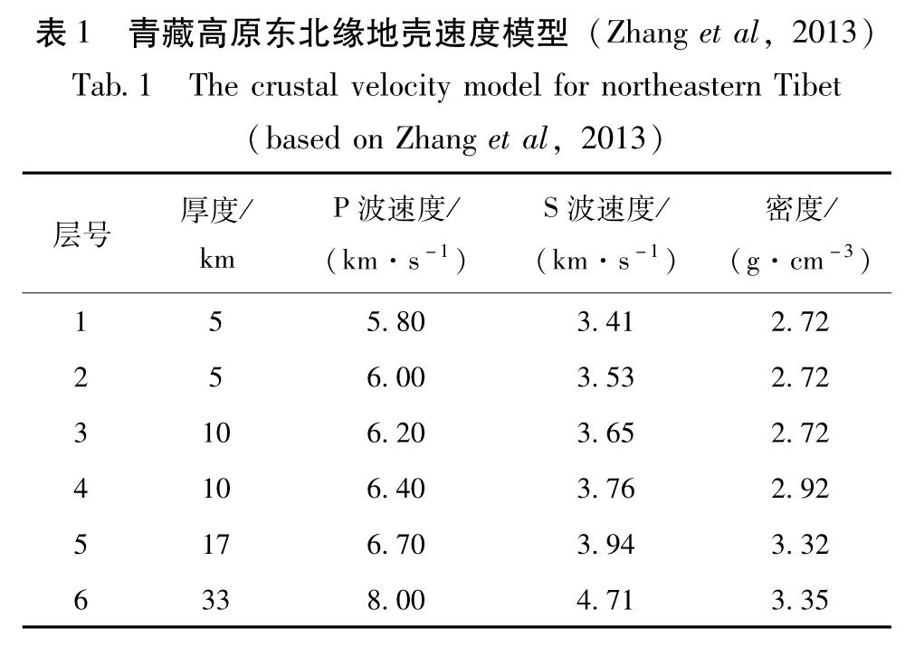
3.2 地壳速度模型目前关于夏河地区的速度结构已经有不少研究结果,如Xu和Song(2010)联合反演青藏高原东缘P波速度和莫霍面深度所设定的初始速度模型; 李少华等(2012)利用甘肃东南部及邻区24个宽频带固定地震台站记录的2008年8月1日汶川地震余震的三分量全波形资料,采用小生境遗传算法和反射率法相结合的波形反演方法,给出了甘肃东南部地壳速度模型; Zhang等(2013)布设了一条跨越甘肃合作—景泰、长约430 km的人工地震高分辨率宽角反射/折射探测剖面,得到了区域内的P波速度模型; 肖卓和高原(2017)对青藏高原东北缘及其邻区进行双差成像时,分别选取以上3种速度模型作为初始模型进行反演效果测试,结果显示Zhang等(2013)研究得到的速度模型总走时残差(均方根、均值、方差)最小,震源位置空间误差均值最小,因此本文将其作为最佳速度模型(表1)。
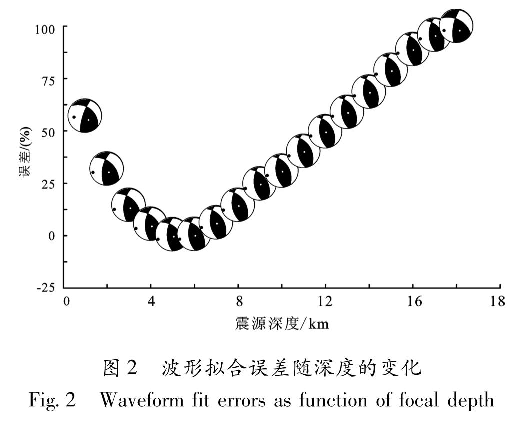
3.3 CAP方法反演结果本文利用CAP方法反演夏河MS5.7地震的震源机制解,图2波形拟合结果显示震源机制在震源深度为5.4 km时拟合结果最好,最佳双力偶解节面 Ⅰ 的走向为305°、倾角为52°、滑动角为50°,节面 Ⅱ 的走向为179°、倾角为53°、滑动角为129°。
从不同国内外研究机构给出的夏河MS5.7地震震源机制解(表2)可以看出,该次地震为逆冲兼走滑型,节面走向为NNW,但震源深度存在差异,在5.4~16.3 km。本文得到的震源机制解结果与GCMT和张波等(2020)给出的结果较为一致,表明本文利用CAP方法得到的结果比较可靠。图3为夏河MS5.7地震波形拟合相关系数,共有12个台站54个震相参与反演,其中相关系数≥90%的有29个,比例为53.7%; 相关系数≥80%的有45个,比例为83.3%; 相关系数≥70%的有54个,比例为100%,反演结果较可靠。
图3 夏河MS5.7地震理论(红线)和实际(黑线)波形拟合结果
Fig.3 Comparison of the theoretical(red line)and observed(black line)waves of the Xiahe MS5.7 earthquake by the CAP inversion method表2 不同机构给出的夏河MS5.7地震震源机制解及震源深度
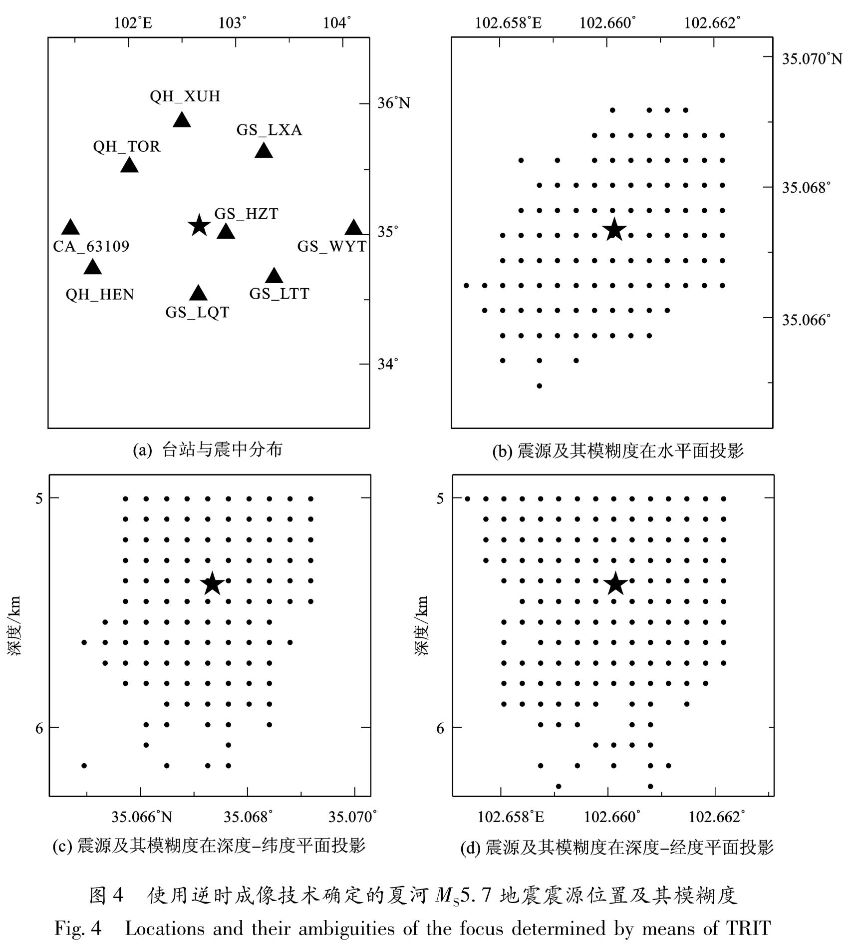
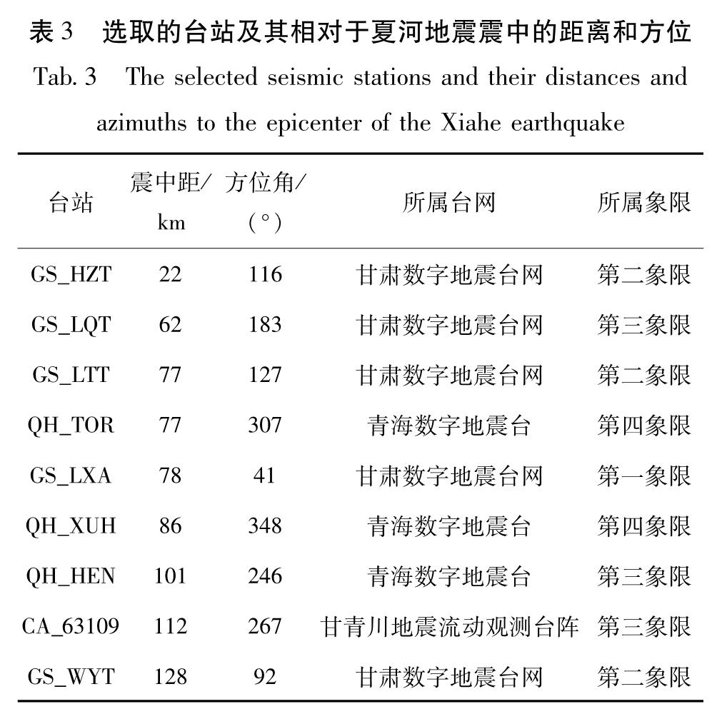
Tab.2 Focal mechanisms and focal depths of the Xiahe MS5.7 earthquake provided by different institutes3.4 逆时成像技术测定震源深度本文选择9个震中距小于130 km的台站(图4、表3),平均震中距为82 km,最近台站(GS_HZT)的震中距仅为22 km。从图4可以看出,这些台站对夏河地震震中的包围较好,在四象限均有分布。因此,使用这些台站的资料有利于确定这次地震的震源深度。
基于表1所示的地壳速度模型,本文测定夏河地震的破裂起始时刻为2019年10月28日1时56分47.41秒,震中位置(35.067°N,102.660°E),震源深度5.4 km。发震时刻、震中纬度、震中经度和震源深度的不确定性依次为0.08 s 、0.005°、0.005°和1.0 km(图4)。
图4 使用逆时成像技术确定的夏河MS5.7地震震源位置及其模糊度
Fig.4 Locations and their ambiguities of the focus determined by means of TRIT4 讨论
4.1 计算结果本文采用CAP方法反演得到的2019年夏河MS5.7地震的震源机制解与GCMT和张波等(2020)得出的结果较为一致,皆为逆冲兼具少量走滑类型。考虑到本文收集了更丰富、对震中方位覆盖更好的12个台站的地震波形资料,采用了更贴近实际、经过研究区域层析成像研究(肖卓,高原,2017)筛选的地壳速度模型(Zhang et al,2013),虽然在CAP反演中对地壳速度模型要求不高,但罗钧(2013)和潘瑞等(2019)研究均表明一个贴近实际的地壳速度模型能够获得较准确的震源机制解,因此,本文反演得到的震源机制解具有较高的可靠性。
本文利用CAP方法得出的夏河MS5.7地震震源深度较浅(5.4 km),比不同机构得到的结果都浅,但与张波等(2020)的结果(震源深度为5.9 km)接近。其原因为研究机构需在震后短时间内根据区域地震台站波形资料和基于Crust 1.0或Crust 2.0等区域地壳速度模型获得的格林函数库计算并公布震源机制结果,而个人研究则有充足时间搜集不同地震台网的观测资料、测试不同速度模型下反演结果的优劣,因此震源深度的差异可能与使用的观测资料和速度模型不尽相同有关。为了进一步确认夏河MS5.7地震的震源深度,本文使用逆时成像技术对其震源深度进行了再次测定,并确定了夏河地震的起始破裂点的位置。定位结果表明,夏河地震发生于2019年10月28日1时56分(47.41±0.08)s,震中位置(35.067±0.005)°N、(102.660±0.005°)E,震源深度(5.3±1.0)km。逆时成像技术测定的震源位置在水平面、深度-纬度和深度-经度剖面的模糊度都分布均匀、相对较好。基于近震宽频带波形的CAP方法反演得到的该地区其他中等地震事件,如2013年岷县漳县6.6级地震(李晓峰等,2013)、2013年岷县4.5级地震(王丽霞,张晖,2017)和2011年甘肃迭部4.0级地震(张辉等,2013)的震源深度为6~7 km,这些研究结果均表明该地区的发震深度较浅,因此本文得到的夏河地震的震源深度较为可靠。
4.2 发震构造夏河MS5.7地震震中周边发育4条断裂(图1),分别为夏河断裂(F1)、达麦—合作断裂(F2)、临潭—宕昌断裂(F3)、西秦岭北缘断裂(F4),其中西秦岭北缘断裂锅麻滩段和临潭—宕昌断裂西段距离夏河MS5.7地震震中较远(分别为27 km、19 km),因此判定这两条断裂不是本次地震的发震断层。本文得到的夏河地震的发震断层节面走向为305°,与震中附近夏河断裂东段走向(110°)两者之间的夹角仅为15°; 本文得到的发震构造和滑动角为50°,与夏河断裂兼具逆冲和左旋走滑分量的活动性质相一致。另外,达麦—合作断裂位于二叠系与三叠系之间,而夏河断裂发育于三叠系内部,达麦—合作断裂的深度相对更深,而本文得到的夏河地震震源深度为5.4 km,根据震源位置和发震断层面倾角的几何关系,将震源位置投影至水平面后,震中距离发震断层约4.1 km,而夏河断裂距离夏河地震震中北侧约 2.5 km,因此节面Ⅰ与夏河断裂构造特征具有较好的匹配性,推断夏河断裂为本次地震的发震断层。
5 结论
本文使用青海、甘肃和四川地震台网宽频带数字地震波形资料,利用CAP方法反演2019年夏河MS5.7地震的震源机制解,并结合逆时成像技术对其震源深度进行了再次测定,得到以下主要结论:
(1)本文反演获得的震源机制解与GCMT和张波等(2020)给出的结果较为一致。节面Ⅰ参数(走向305°/倾角52°/滑动角50°)与张波等(2020)基于遥感解译新发现并暂命名为夏河断裂的隐伏断裂产状(走向312°/倾角42°/滑动角48°)基本一致,因此节面Ⅰ(走向305°/倾角52°/滑动角50°)应为夏河MS5.7地震的发震断层面。
(2)本文得到的夏河地震的震源深度为5.4 km,比不同机构得到的结果都浅,与张波等(2020)给出的结果相近,符合该地区地震震源深度较浅的特征。
(3)由于缺乏近台数据,USGS和GCMT等机构给出的远震事件震源深度常存在较大的不确定性,如2012年南北地震带5次中等地震(李志伟等,2015)、2016年广西苍梧5.4级地震(赵韬等,2019)、2019年甘肃夏河MS5.7地震的震源深度均存在明显偏差,未来在使用USGS和GCMT等机构给出的远震事件震源深度时,应该考虑震源深度的误差。
-
何文贵,郑文俊,王爱国,等.2013.临潭—宕昌断裂新活动特征与岷县漳县MS6.6地震关系研究[J].地震工程学报,35(4):751-760.
- 侯康明,雷中生,万夫岭,等.2005.1879年武都南8级大地震及其同震破裂研究[J].中国地震,21(3):295-310.
- 黄浩,付虹,沙成宁,等.2017.2016年青海门源MS6.4地震重定位[J].地震学报,39(2):176-187.
- 李少华,王彦宾,梁子斌,等.2012.甘肃东南部地壳速度结构的区域地震波形反演[J].地球物理学报,55(4):1186-1197.
- 李晓峰,裴惠娟,徐辉,等.2013.2013年7月22日岷县漳县6.6级地震震源机制解[J].地震工程学报,35(3):459-462.
- 李志伟,黄志斌,王晓欣,等.2015.USGS地震目录中4~5级震源深度异常地震可靠性初步研究:以南北地震带若干地震为例[J].地球物理学报,58(4):1236-1250.
- 吕坚,郑勇,倪四道,等.2008.2005年11月26日九江—瑞昌MS5.7、MS4.8地震的震源机制解与发震构造研究[J].地球物理学报,51(1):158-164.
- 罗钧.2013.川滇块体及周边现今震源机制和应力场特征研究[D].北京:中国地震局地震预测研究所.
- 潘睿,姜金钟,付虹,等.2019.2017年云南漾濞MS5.1及MS4.8地震震源机制解和震源深度测定[J].地震研究,42(3):338-348.
- 王丽霞,张辉.2017.甘肃岷县两次中等地震震源机制解及其误差分析[J].国际地震动态,(8):51-52.
- 韦生吉,倪四道,崇加军,等.2009.2003年8月16日赤峰地震:一个可能发生在下地壳的地震?[J].地球物理学报,52(1):111-119.
- 魏强,许力生,李春来,等.2017.2014年鲁甸MS6.5地震序列发震构造的再研究[J].地震地质,39(2):374-389.
- 肖卓,高原.2017.利用双差成像方法反演青藏高原东北缘及其邻区地壳速度结构[J].地球物理学报,60(6):2213-2225.
- 许力生,杜海林,严川,等.2013a.一种确定震源中心的方法:逆时成像技术(一)——原理与数值实验[J].地球物理学报,56(4):1190-1206.
- 许力生,严川,张旭,等.2013b.一种确定震源中心的方法:逆时成像技术(二)——基于人工地震的检验[J].地球物理学报,56(12):4009-4027.
- 俞晶星,郑文俊,袁道阳,等.2012.西秦岭西段光盖山—迭山断裂带坪定—化马断裂的新活动性与滑动速率[J].第四纪研究,32(5):957-967.
- 曾祥方,罗艳,韩立波,等.2013.2013年4月20日四川芦山MS7.0地震:一个高角度逆冲地震[J].地球物理学报,56(4):1418-1424.
- 张波,王爱国,袁道阳,等.2020.甘肃夏河断裂新活动的发现——兼论2019年夏河MS5.7地震的发震构造[J].地震学报,42(5):629-644.
- 张国伟,郭安林,姚安平.2004.中国大陆构造中的西秦岭—松潘大陆构造结[J].地学前缘,11(3):23-32.
- 张辉,王熠熙,徐辉.2013.甘肃迭部MS4.0地震震源机制解和震源深度精确测定[J].地震工程学报,35(4):908-913.
- 赵博,高原,刘杰,等.2019.2010年以来四川地区中强地震震源机制反演及深度确定[J].地球物理学报,62(1):130-142.
- 赵韬,储日升,倪四道,等.2019.广西苍梧MS5.4地震震源深度[J].地震地质,41(3):619-632.
- 郑文俊,袁道阳,何文贵,等.2013.甘肃东南地区构造活动与2013年岷县—漳县6.6级地震孕震机制[J].地球物理学报,56(12):4058-4071.
- Jiang J Z,Li J,Fu H.2019.Seismicity analysis of the 2016 MS5.0 Yunlong Earthquake,Yunnan,China and its tectonic implications[J].Pure and Applied Geophysics,176(3):1225-1241.
- Lei X,Wang Z,Su J.2019.The December 2018 ML5.7 and January 2019 ML5.3 earthquakes in South Sichuan Basin induced by shale gas hydraulic fracturing[J].Seismological Research Letters,90(3):1099-1110.
- Liang H,Fu Z,Li C L,et al.2020.Preliminary analysis of the shear-wave splitting observations from the Qiaojia seismic array[J].Earthquake Science,33(2):82-97.
- Xu Z J,Song X.2012.Joint inversion for crustal and Pn velocities and Moho depth in Eastern Margin of the Tibetan Plateau[J].Tectonophysics,491(1):185-193.
- Zhang Z J,Bai Z M,Klemperer S L,et al.2013.Crustal structure across northeastern Tibet from wide-angle seismic profiling:Constraints on the Caledonian Qilian orogeny and its reactivation[J].Tectonophysics,606:140-159.
- Zhao L S,Helmberger D V.1994.Source estimation from broadband regional seismograms[J].Bull Seis Soc Amer,84(1):91-104.
- Zhu L P,Helmberger D V.1996.Advancement in source estimation techniques using broadband regional seismograms[J].Bull Seis Soc Amer,86(5):1634-1641.
- Zhu L P,Rivera L A.2002.A note on the dynamic and static displacements from a point source in multilayered media[J].Geophys J Int,148:619-627.
