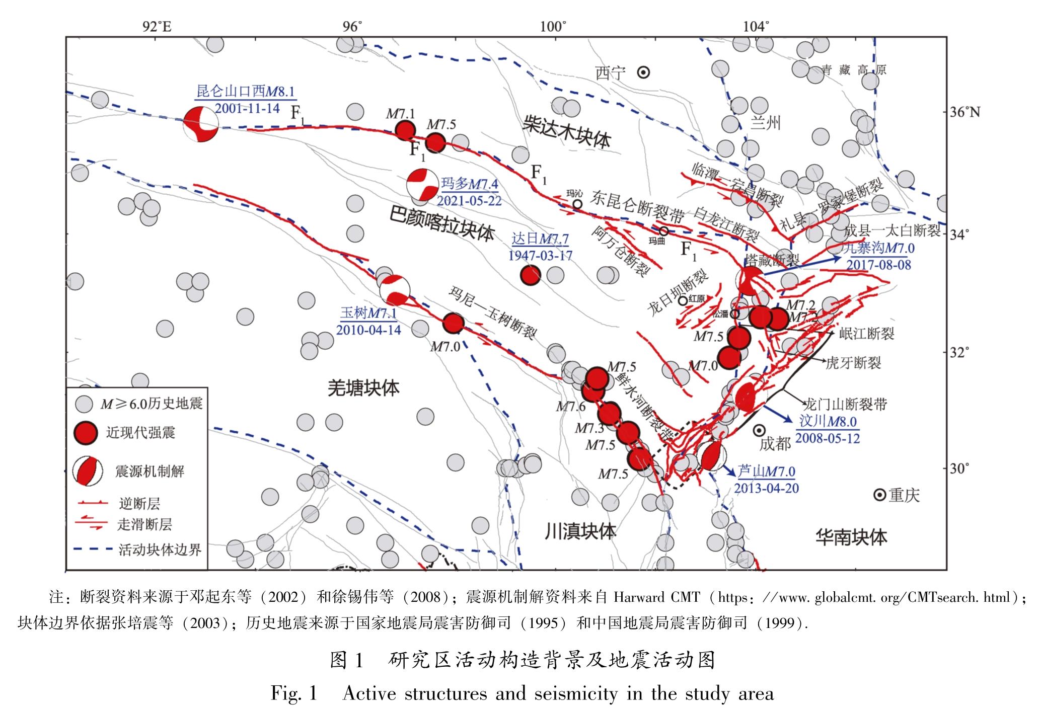
4.1 东昆仑断裂带东部及其邻区断裂的晚第四纪活动特征
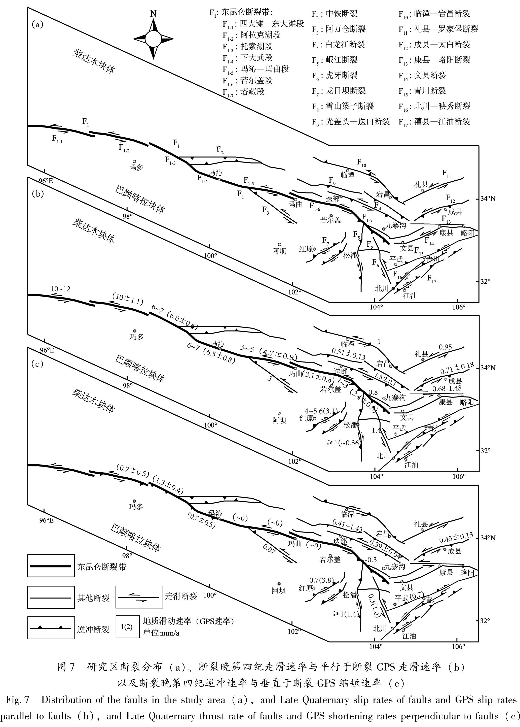
东昆仑断裂带东部及其邻区各断裂之间的构造关系比较复杂,前人的研究给出了该区主要断裂的运动学定量结果。对于区域主要控制断裂东昆仑断裂带,一些学者通过河流阶地及断错地貌结合年代学结果分析得出:西大滩—东大滩段全新世晚期滑动速率为10~12 mm/a(任金卫,1993; 青海省地震局,1999; Van der Woerd et al,2000); 托索湖段滑动速率为6~7 mm/a(Harkins et al,2010; Kirby et al,2007); 下大武段滑动速率为6~7 mm/a(青海省地震局,1999); 玛沁—玛曲段全新世以来的滑动速率为3~5 mm/a(青海省地震局,1999; 何文贵等,2006; Kirby et al,2007); 若尔盖段的滑动速率为1~3 mm/a(付俊东,2012); 塔藏断裂全新世右旋滑动速率为0.8 mm/a,逆冲速率约为0.3 mm/a(Ren et al,2013)。基于类似的方法,李陈侠等(2016)获得阿万仓断裂晚第四纪以来的平均左旋水平滑动速率为3 mm/a; 垂直滑动速率为0.07 mm/a; 刘兴旺等(2015)获得迭部白龙江断裂左旋走滑速率为(1.3±0.1)mm/a,垂直滑动速率为(0.39±0.04)mm/a; 俞晶星等(2012)获得了光盖山—迭山断裂晚第四纪以来的垂直滑动速率为(0.49±0.08)~(1.15±0.28)mm/a,左旋走滑速率为(0.51±0.13)mm/a; 韩竹军等(2001)得到礼县—罗家堡断裂的左旋走滑速率为0.95 mm/a; 贾伟等(2012)得到的康县—略阳断裂全新世以来左旋走滑速率从0.68 mm/a增大至1.48 mm/a; Zheng等(2016)获得成县—太白断裂的左旋走滑速率为(0.71±0.18)mm/a,逆冲速率为(0.43±0.13)mm/a。徐锡伟等(2008)通过卫星影像解译和野外考察得出龙日坝断裂北东段晚更新世以来平均右旋滑动速率为(5.4±2.0)mm/a,垂直运动速率约为0.7 mm/a。最新的地震调查结果认为龙日坝断裂上长期地质滑动速率大于4.0 mm/a(Ren et al,2013)。第四纪以来,岷江断裂为具有左旋走滑位移的逆断裂,晚更新世以来具有强烈的活动性,断层左旋水平滑动速率等于或大于1 mm/a,根据阶地的海拔高度变化推测其垂直滑动速率等于或大于1 mm/a(邓起东等,1994)。周荣军等(2006)根据涪江一、二级阶地位错和洪积扇位错及阶地面年龄,推测横跨虎牙断裂的左旋走滑速率为1.4 mm/a,垂直运动速率为0.3 mm/a。
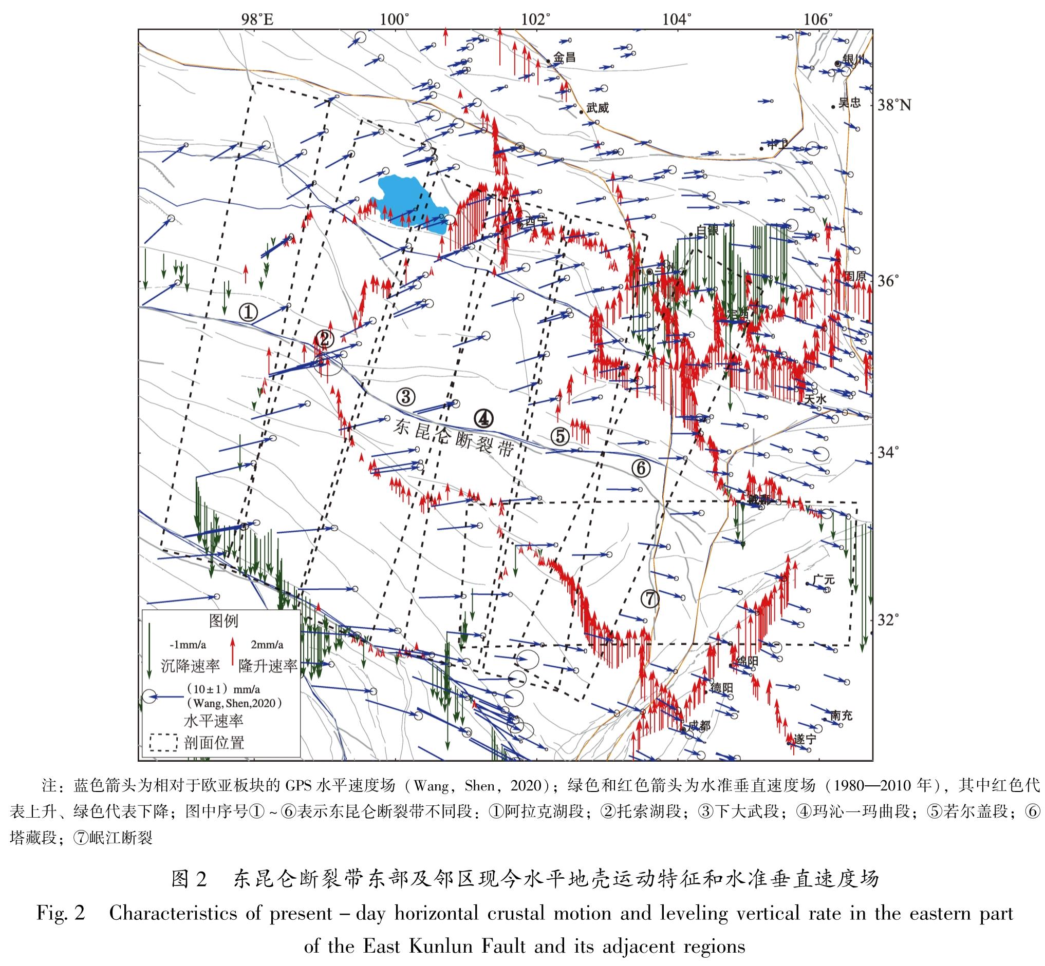
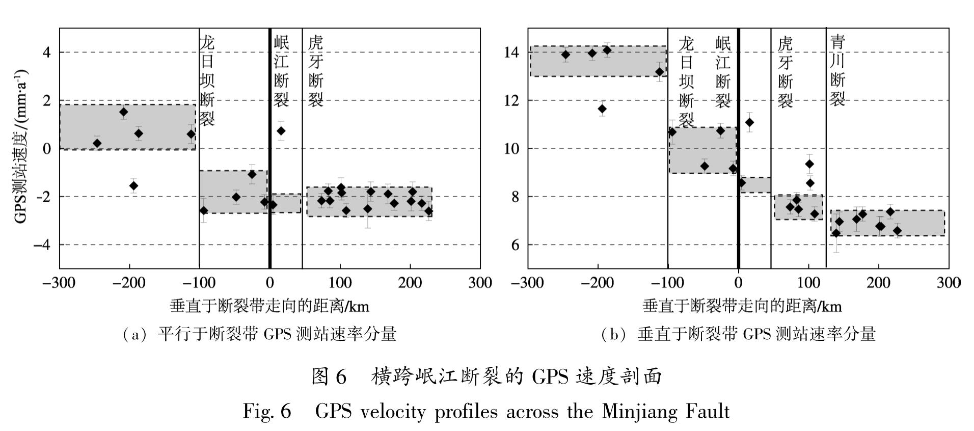
[HJ1.8mm]4.2 断裂地质滑动速率和基于GPS剖面计算的断裂滑动速率的分布特征
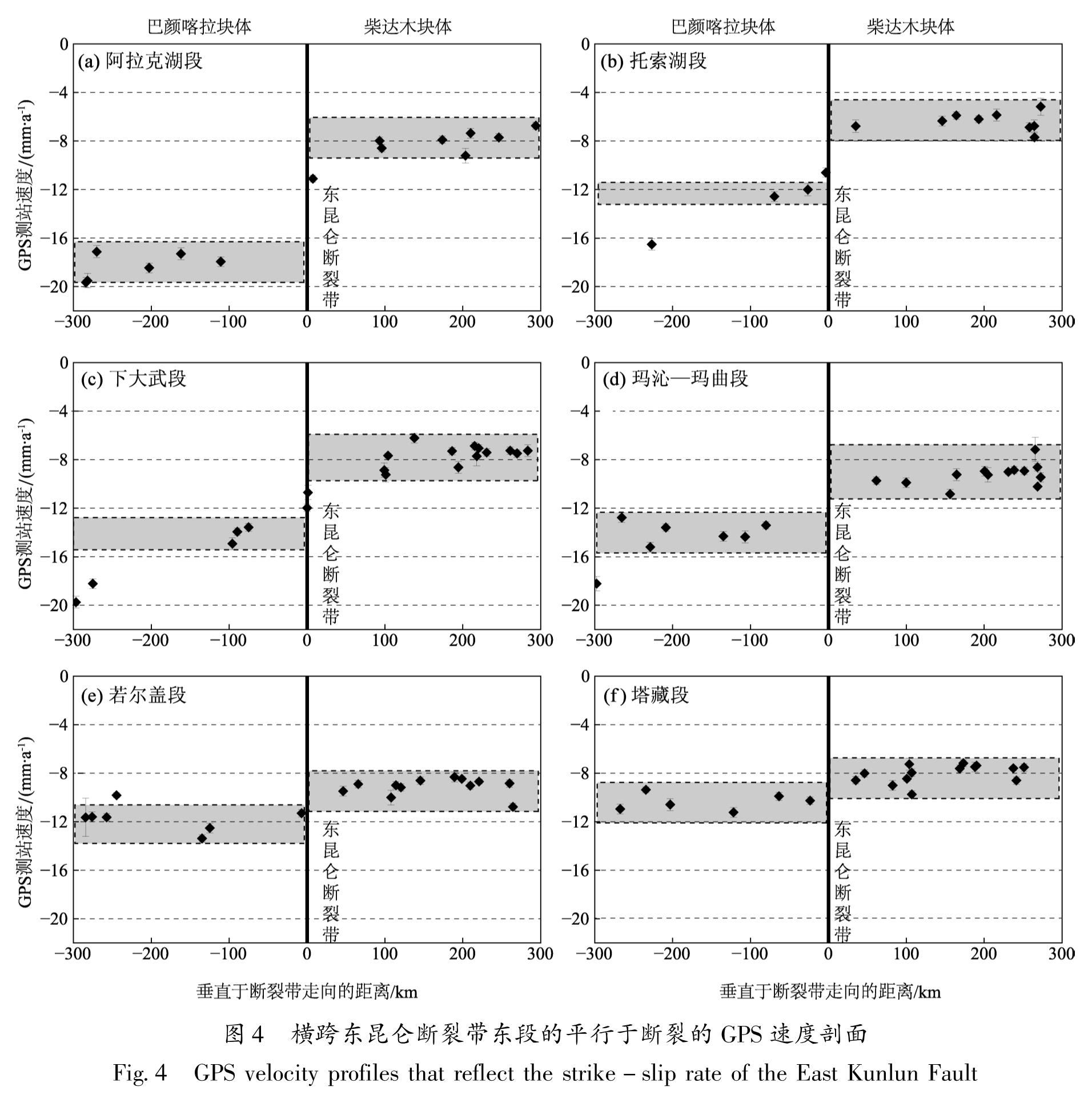
东昆仑断裂带作为高原内部大型走滑断裂,其活动习性和滑动速率分布特征是高原的变形模式的直接反映。图7为总结了前人研究的东昆仑断裂带地质滑动速率和基于GPS跨断层剖面所确定的平行于断裂的走滑速率和垂直于断裂的张压速率。图中不同断裂段,基于GPS获取的断层滑动速率和基于地质方法获取的断层滑动速率一致性相对较好,说明两者是可以相互补充的。东昆仑断裂带阿拉克湖段的相关研究较少,本文基于跨断层GPS获取的滑动速率弥补了该处的滑动速率缺失问题。
总体来看,东昆仑断裂带自西向东的走滑速率衰减是非常明显的,从西大滩—东大滩和阿拉克湖段约为10 mm/a,向东到塔藏段衰减到约2 mm/a。东昆仑断裂带并不是一条纯走滑断裂,阿拉克湖段、托索湖段、下大武段和塔藏段均表现出一定的弱挤压特征。断裂东部尾端及其北东方向的次级断裂均表现出逆冲左旋走滑的特征。巴颜喀拉块体内部的次级断裂除虎牙断裂外,均表现出右旋走滑兼有逆冲的运动特征。
4.3 滑动速率所反映的区域变形分配特征
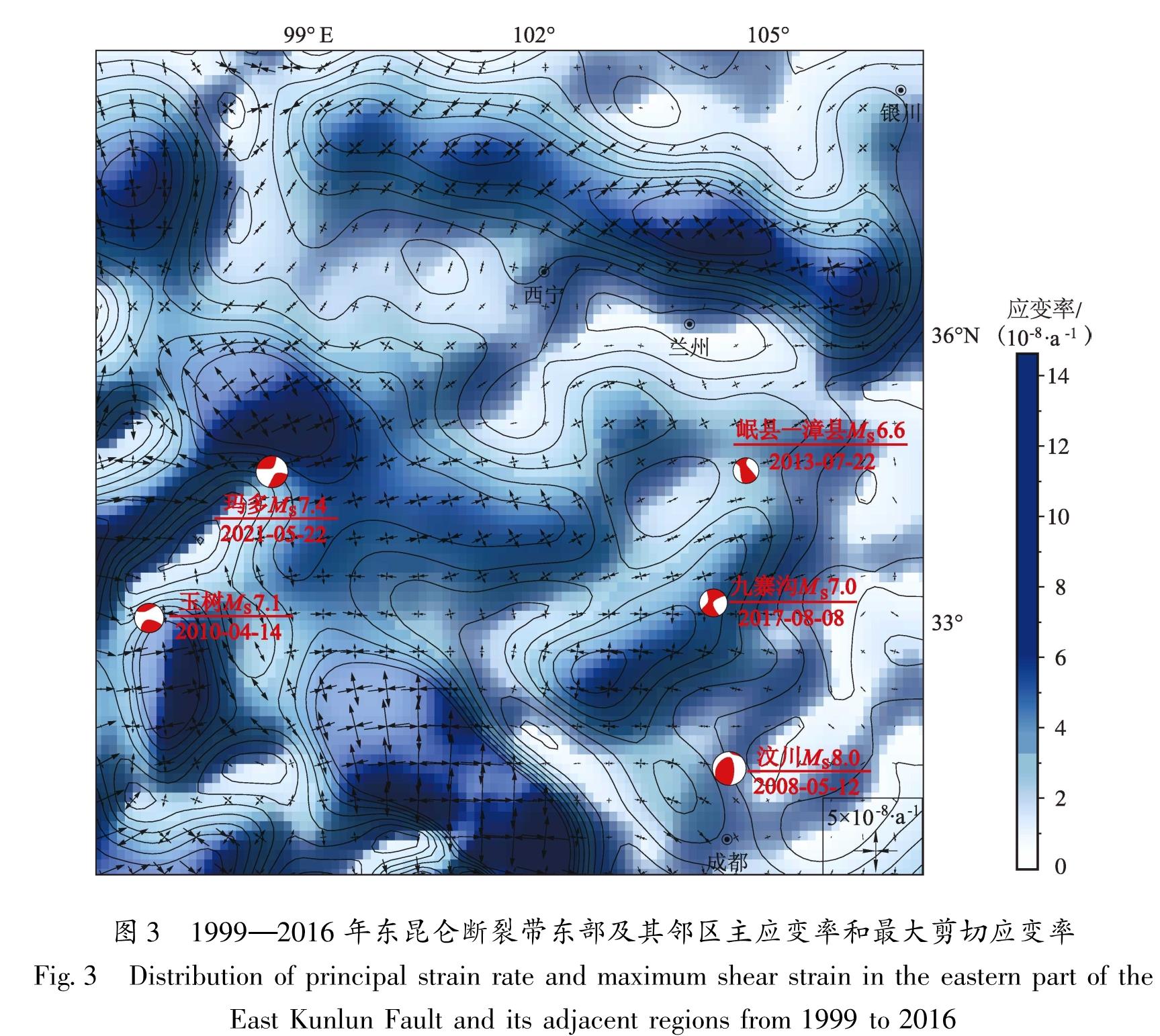
规模巨大的断裂往往是由多条小型断裂通过不同的几何结构和活动形式组合,并在多次的断裂活动后逐渐贯通形成的。断裂带滑动速率的分布特征直接反映了断裂及其两侧邻区一定范围内的地壳变形(Stein et al,1988; Alexander et al,1994)。东昆仑断裂带滑动速率在阿拉克湖段以西均为10 mm/a,向东到托索湖段降为6~7 mm/a,挤压速率为(1.3±0.4)mm/a,缺失的滑动速率一部分转为断裂的逆冲运动,另一部分推测转换到托索湖段和下大武段之间的中铁断裂上; 下大武段和托索湖段滑动速率相近; 过下大武段后的玛沁—玛曲段的滑动速率降为3~5 mm/a,缺失的速率转换到阿万仓断裂上(李陈侠等,2016); 过玛沁—玛曲段后的若尔盖段的滑动速率略小于玛沁—玛曲段; 过若尔盖段后为东昆仑断裂带的尾端塔藏段,滑动速率一部分转为塔藏断裂的逆冲运动。
岷山隆起带处于东昆仑断裂带塔藏段南侧,西边以南北向岷江断裂为界,东边以南北向虎牙断裂为界。关于岷山隆起的原因主要有两种认识,一是认为岷山隆起是由东昆仑断裂带尾端转化作用形成(Chen et al,1994; Kirby et al,2000; Van der Woerd et al,2000),其理论依据是断裂段之间的相互转换是通过拉分或挤压的阶区、雁列斜接、尾端散开等形式进行的,特别是走滑断裂端部的位移分布是通过拉分的盆地或是隆起的山脉来调整和降低的(Keller et al,1982; Deng et al,1986)。另一种是认为青藏高原内部的软流圈物质向NE和SSE向流动(Royden et al,2008; Clark et al,2000,2005),驱动巴颜喀拉块体东缘上地壳沿中上地壳低阻层东向运移,受到阻挡作用,软弱的岷山隆起带发生地壳褶皱变形并向东逆冲推覆从而形成高耸的岷山山脉,岷江断裂与虎牙断裂的走滑运动加速了岷山的隆起(闵刚等,2017)。本文分析东昆仑断裂带东部及其邻区断裂之间滑动速率转换关系认为,岷山地区的隆起变形主要是巴颜喀拉块体自西向东的运动受华南块体的阻挡所致,而不是东昆仑断裂带向东延展引起的构造转换。
甘东南地区位于东昆仑断裂带若尔盖段和塔藏段以北的区域,区内构造变形复杂,主要发育了NW和NE走向的两组活动断裂,共同组成“V”型构造体系。NW走向的断裂主要包括临潭—宕昌断裂、光盖头—迭山断裂和白龙江断裂; NE走向的断裂主要包括礼县—罗家堡断裂、成县—太白断裂、康县—略阳断裂和康县断裂。两组断裂的运动变形主要受控于东昆仑断裂带和西秦岭北缘断裂带两大活动断裂。图7b、c给出了总结前人研究结果的甘东南地区主要断裂的滑动速率。对于断裂滑动速率等运动学参数所反映的区域构造变形特征,甘东南地区组成“V”型断裂体系的两组断裂,通过各条断裂相对较低的滑动速率(包括走滑和逆冲),以及断裂之间隆起山脉及不同时代盆地的变形,共同承担了自东昆仑断裂带向西秦岭北缘断裂带过渡过程中运动分量的吸收和转换(Zheng et al,2013)。从区域构造的几何特征及运动学特征分析认为东昆仑断裂带的向北挤压和向东的运动是甘东南地区构造应力集中的主要动力,但是考虑到东昆仑断裂带过玛沁—玛曲段后的若尔盖段的滑动速率略小于玛沁—玛曲段,分析认为区内主要断裂滑动速率并不是由东昆仑断裂带转换而来,而是由于区内主要断裂承担了东昆仑断裂带向北东推挤和扩展到西秦岭北缘断裂带的过渡作用,青藏高原向北东扩展过程中两大断裂体系的相互作用是区内主要断裂运动变形的动力来源。
图7 研究区断裂分布(a)、断裂晚第四纪走滑速率与平行于断裂GPS走滑速率(b)以及断裂晚第四纪逆冲速率与垂直于断裂GPS缩短速率(c)
Fig.7 Distribution of the faults in the study area(a),and Late Quaternary slip rates of faults and GPS slip rates parallel to faults(b),and Late Quaternary thrust rate of faults and GPS shortening rates perpendicular to faults(c)