2.1 数据来源与预处理
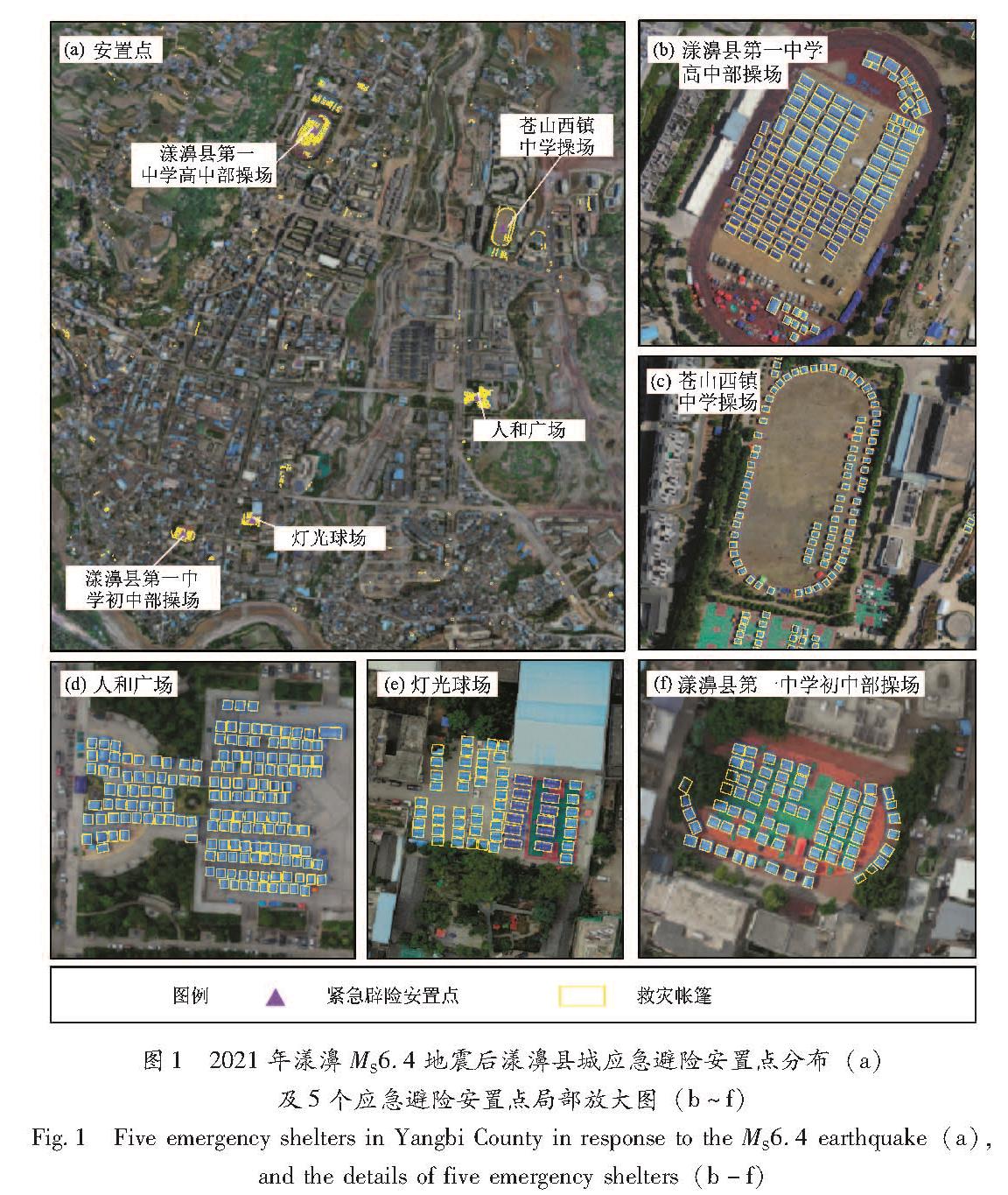
漾濞县城应急避险安置点数据、道路分布、建筑物轮廓及震害数据主要基于震后漾濞县城无人机航拍正射影像人工矢量化得到; 人口数据来源于《漾濞年鉴(2020年)》(漾濞彝族自治县地方志编纂委员会办公室,2020); 建设用地类型等基础数据来源于漾濞县城市总体规划图; 受灾人口、建筑物破坏比等震害数据来源于《云南漾濞6.4级地震灾害损失评估报告》。
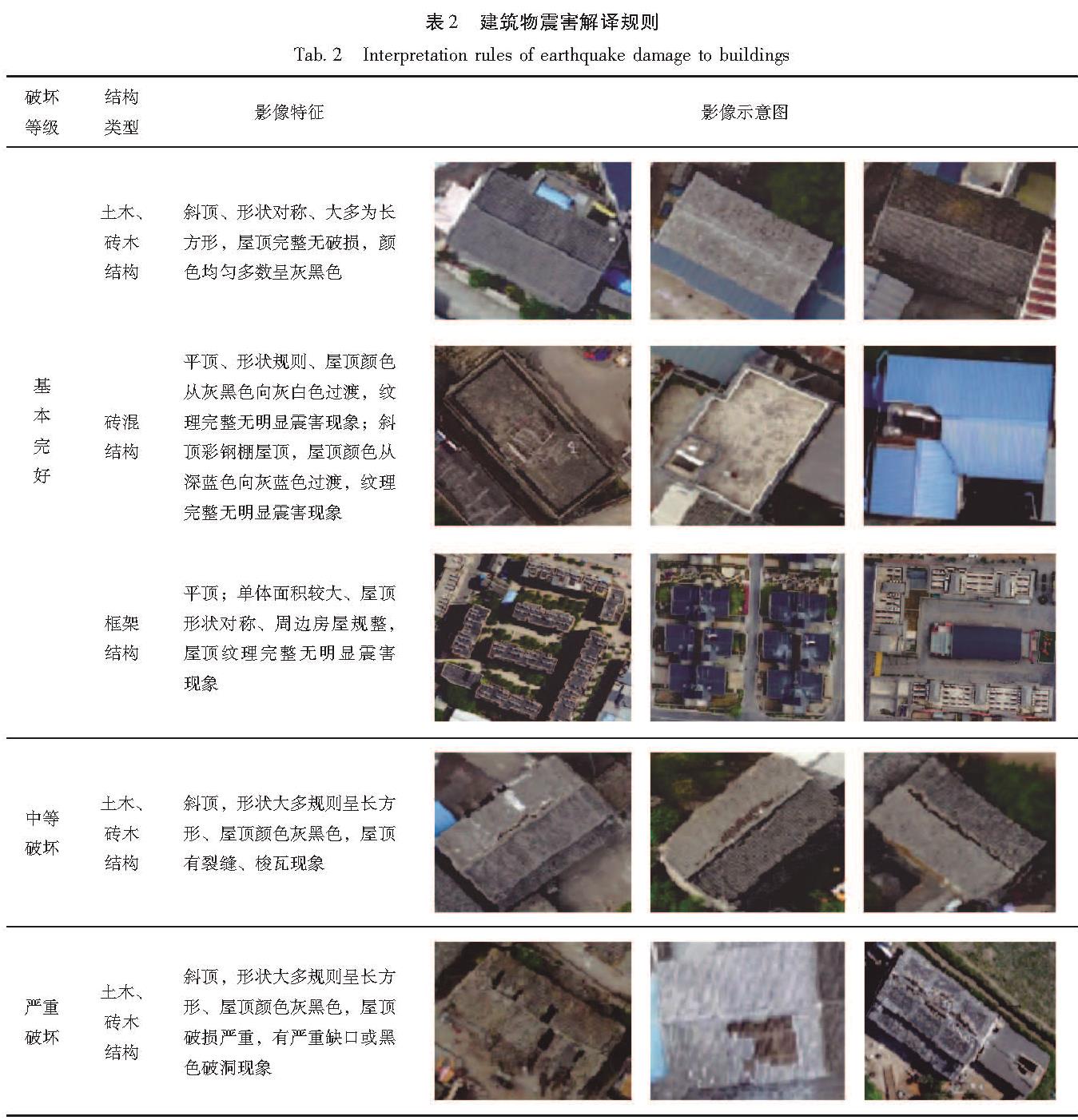
无人机影像数据是云南省地震局现场工作队采用由大疆无人机精灵4和飞马D2000航拍的震后2天漾濞县城高分辨率正射影像,影像面积约7 km2,考虑到县城边上的村庄应急安置场地充裕且距离县城较远,所以剔除县城边上的村庄影像,主要以主城区为研究区域。然后通过目视解译获得研究区5 339栋建筑图斑、县城主干道分布、5个安置点的位置及场地面积参数,并基于建筑物正射影像的纹理、形状及震害现象人工识别建筑物破坏等级。
2.2 研究方法
泰森多边形又名Voronoi图,是对空间平面的一种剖分,可用于解决最近点、最小封闭圆、邻接、接近度和可达性等空间分析问题。泰森多边形定义与性质(陈军,2002; 王玥等,2021)为:假设二维欧几里德平面上离散生长点集合
P={p1,p2,…,pn}(2≤n<∞) (1)
则
V(pi)={p|d(p,pi)≤d(p,pj)}(i≠j,i=1,2,…,n) (2)
生成的区域V(pi)即为发生元pi的Voronoi多边形,而集合V(P)构成P的Voronoi图,其中d(p,pj)为两点之间的欧几里德距离。每个Voronoi图内的点到相应发生元的距离最短,这些点受其发生元直接影响,即可将Voronoi图在一定程度上看作是相应发生元的影响范围。
加权泰森多边形定义与性质(张宇等,2017; 李刚等,2006; 王丹丹,2018)为:假设二维欧几里德平面上离散生长点集合
P={p1,p2,…,pn}(2≤n<∞) (3)
wi(i=1,2,…,n)是给定的正实数,则
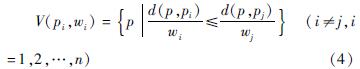
由式(4)生成的区域V(pi,wi)即为发生元pi的Voronoi多边形,而集合V(p,w)构成P的加权Voronoi图。d(p,pj)为两点之间的欧几里德距离,wi为pi的权重。当w1=w2=…=wn时,得到普通Voronoi图。加权泰森多边形中,加权距离等于欧几里德距离除以权重wi,发生元的权重可以理解为其向四周扩张的速度,权重大的多边形具有较大的面积,即具有更大的影响范围。
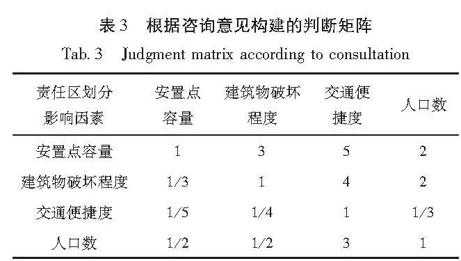
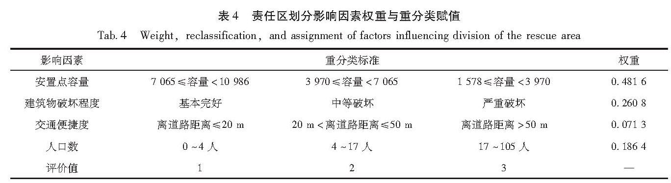
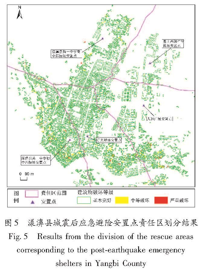
由上可知,泰森多边形的特点是多边形内的任何位置离该多边形发生元的距离最短,而且每个多边形包含且仅包含一个发生元,符合一个应急避险安置点对应一个责任区的需求,也契合居民倾向选择最近安置点的现实。应急避险安置点责任区大小不仅受距离这单一因素的影响,还会受安置点容量、震后灾情、人口分布、交通情况、等多因素的影响。加权泰森多边形可以通过权重把这些影响因素量化后呈现在图面上,实现多影响因素下的责任区划分,进一步提高其合理性。因此,本文拟使用加权泰森多边形法,对漾濞县城震后应急避险安置点责任区进行划分,研究流程如图2所示。首先利用无人机正射影像、漾濞县城基础数据,通过人工矢量化、空间插值等处理,获得基于单栋建筑物的安置点容量插值、建筑物破坏程度、交通便捷度、人口分布数据,然后利用层次分析法计算各责任区划分影像因素的权重,生成应急避险安置点责任区划分成本面数据,最后采用加权泰森多边形法在ArcGIS中实现漾濞县城安置点责任区划分,并分析划分结果。
图2 应急避险安置点责任区划分流程
Fig.2 Process of the division of the rescue areas corresponding to emergency shelters