3.1 地震波初至时刻提取
准确提取地震波初至时刻是计算地震发震时刻和震中位置的关键,本文应用短时窗平均/长时窗平均法(STA/LTA)(Allen,1978)提取地震波初至时刻,选用历元间差分函数作为特征函数:
CF(i)=f(i)-f(i-1) (5)
式中:f(i)为i时刻各方向坐标。短时窗主要表示特征函数在短时间内的变化情况,长时窗则表示信号在当前时段内的平均噪声水平。当检测到地震波信号时,短时窗特征函数的平均值与长时窗平均值的比值会明显增大,当某一时刻长、短时窗的特征函数值比值大于设定的阈值时,则认为地震波到达。
为了更准确地提取地震波初至时刻,本文选取了多种长、短时窗长度和阈值组合,将长时窗分别设置为50~70 s,步长为5 s; 短时窗分别设置为5~20 s,步长为1 s; STA/LTA阈值分别设置为1.8~2.8,步长为0.1。通过不同组合提取地震波初至时刻后发现,长、短时窗长度及阈值的选取需要根据GNSS地震时间序列设定。当长时窗长度较小时,LTA值可能会随时间变化较明显,无法表现出GNSS时间序列的一般特性。当短时窗长度较小时,STA值对地震信号较为敏感,随时间波动较大,可能会将一般噪声识别为地震信号; 而短时窗的长度较大时,其STA值不能较为真实地描述地震信号在某一瞬间的变化状态。
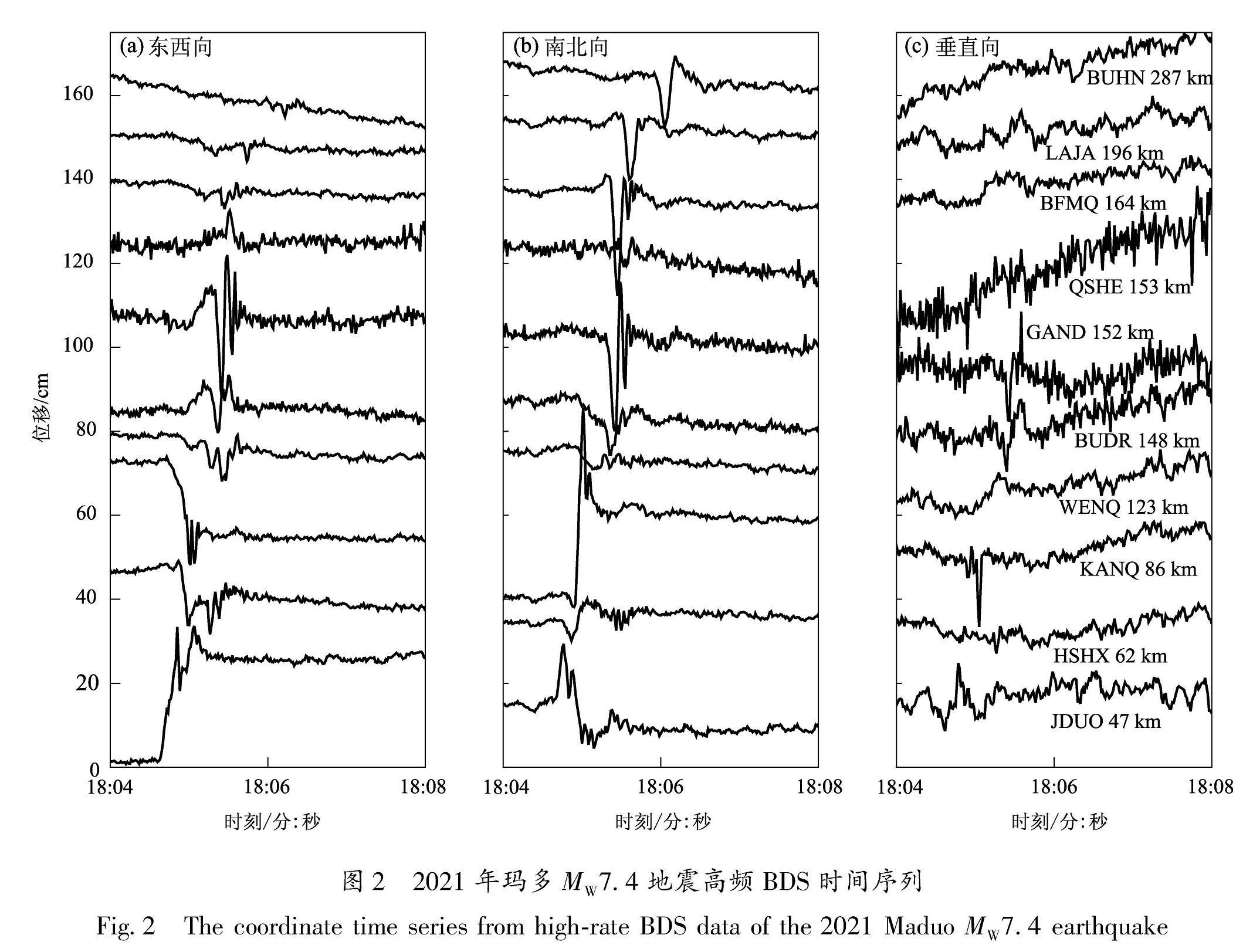
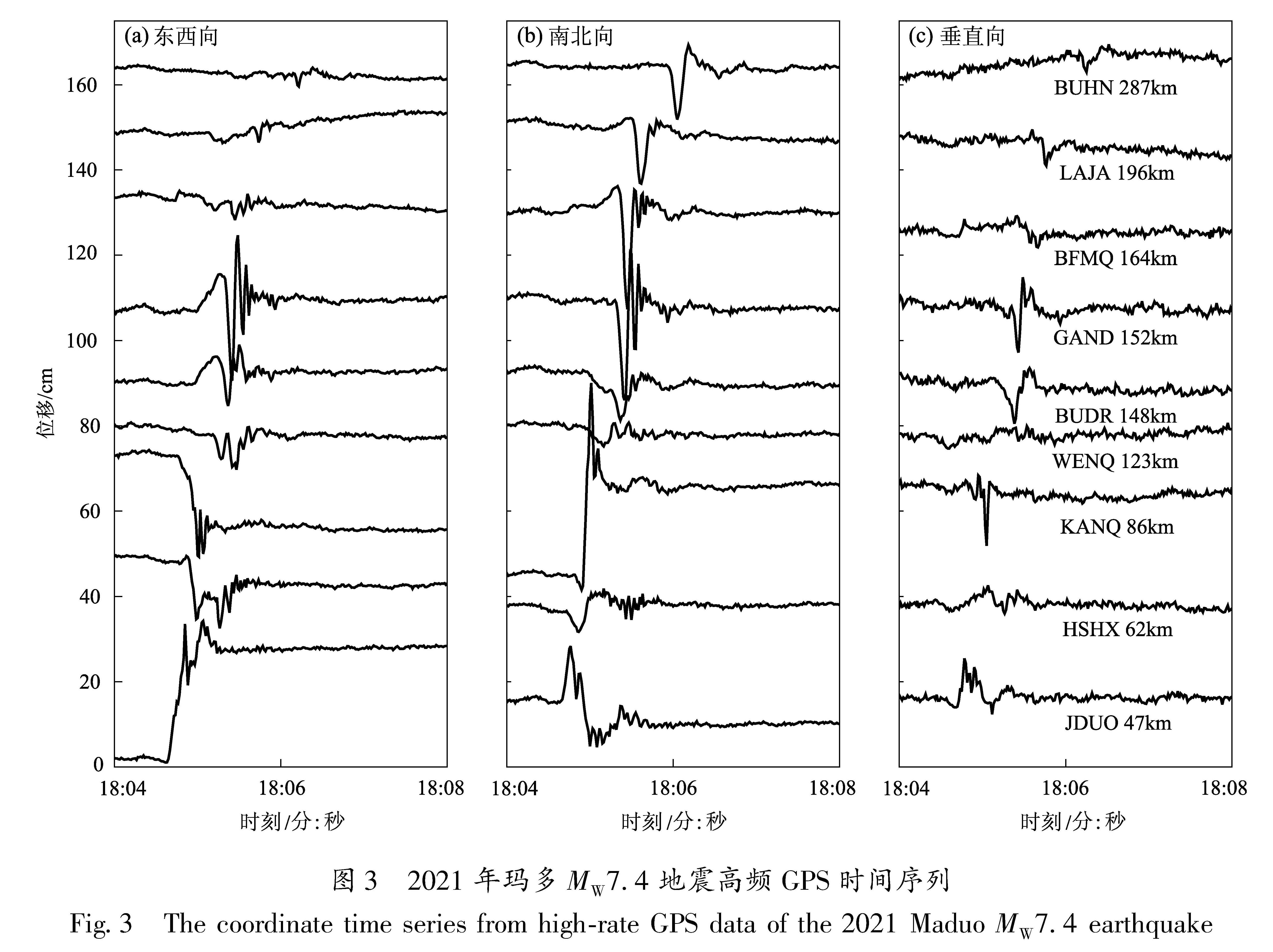
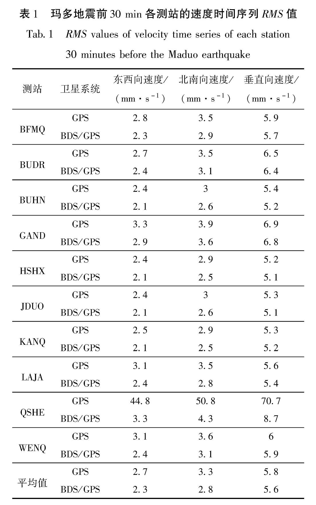
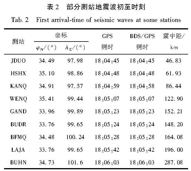
最终,本文选用的长时窗长度为70 s,短时窗长度为9 s,阈值为2.2。利用STA/LTA法提取的各测站地震波初至时刻见表2,其中本文涉及到玛多地震的时间,使用的是国际标准时间。从表2可看出,在更加稳定的KANQ测站的BDS/GPS时间序列中可更早探测到地震波信号。
表2 部分测站地震波初至时刻
Tab.2 First arrival-time of seismic waves at some stations
3.2 震中位置及发震时刻反演
本文采用距离交会法确定地震震中,假设地震的震中坐标为(X,Y,Z),则各测站到震中的距离Di可表示为:

假定地震波在地壳中各个方向的传播速度v是相同的,则根据地震波初至时刻和各台站之间的距离可得如下观测方程:

对上述观测方程进行线性化,通过最小二乘迭代后可计算得到震中和地震波传播速度v。为了加快计算速度,本文将第一个接收到地震波信号的测站坐标记为震中位置的初值。在地震研究中,GNSS测站接收到的地震波一般为S波(波速3~4 km/s),本文分别使用不同波速(3~4 km/s,步长为0.1 km/s)进行计算,最终地震波速度v设为3.2 km/s。地震发震时刻T0可根据上一步中得到的震中坐标(X,Y,Z)和地震波速度计算求得。为了减少计算误差,可对其取平均值:

式中:Di为第i测站至震中的距离; ti为第i测站的地震波初至时刻。
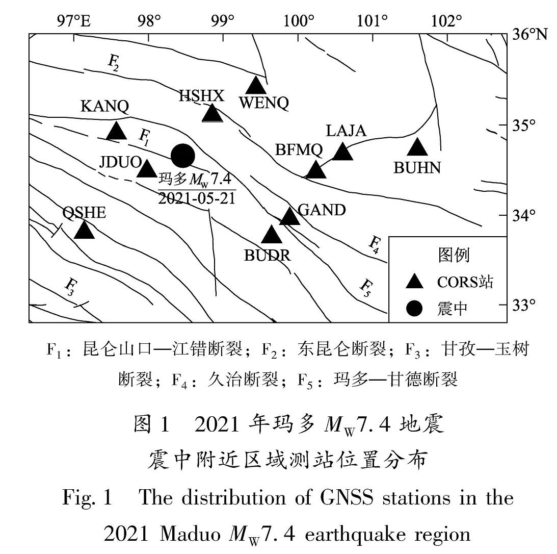
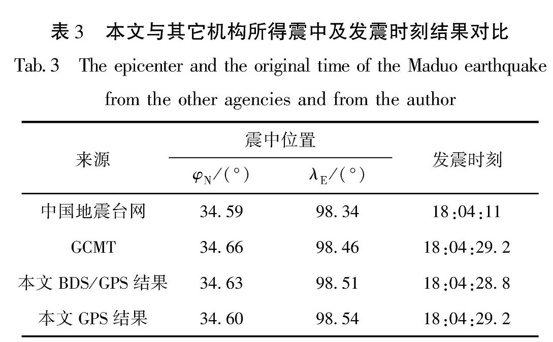
根据玛多地震的GPS和BDS/GPS地震时间序列(图2~4)以及各测站地震波初至时刻(表2),得到了2021年玛多地震的GPS和BDS/GPS地震震中位置和发震时刻分别为(34.6°N,98.54°E),18:04:28.8;(34.63°N,98.51°E),18:04:29.2。
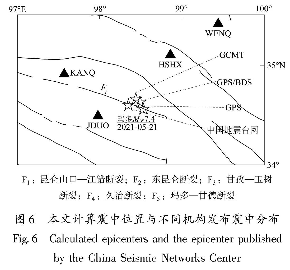
图6 本文计算震中位置与不同机构发布震中分布
Fig.6 Calculated epicenters and the epicenter published by the China Seismic Networks Center
从图6可以看出,本文计算所得震中位置与中国地震台网、GCMT等机构发布的震中位置比较接近(表3)。本文使用BDS/GPS时间序列所得震中位置与GCMT发布的震中位置相差5.8 km,所得发震时刻与GCMT发布结果(18:04:29.2)一致,使用GPS时间序列震中位置与GCMT发布震中位置相差10 km,所得发震时刻与GCMT结果相差0.4s; 使用BDS/GPS时间序列所得震中位置与中国地震台网发布的震中位置相差17.4 km,所得发震时刻与中国地震台网发布结果(18:04:11)相差18.2 s,使用GPS时间序列所得震中与中国地震台网发布的震中位置相差20 km,发震时刻与中国地震台网结果相差17.8 s。利用BDS/GPS时间序列计算的震中位置和发震时刻更加接近实际震中位置与发震时刻。
表3 本文与其它机构所得震中及发震时刻结果对比
Tab.3 The epicenter and the original time of the Maduo earthquake from the other agencies and from the author
3.3 震级确定
日本学者(Kanamori,1977; Hanks,Kanamori,1979)提出了矩震级的概念。矩震级不是利用地震记录波形的振幅来计算震级,而是通过地震矩来确定震级。地震矩是通过GNSS或InSAR等方法获得地表平均滑动后获得的。应用矩震级来表征地震的大小比较准确,但是需要大量复杂计算得到,耗时较大。
Gutenberg(1945)推导出了地震面波最大水平位移、震中距和地震震级的经验关系公式为:
M=log(PGD)+1.66log(R)+2.0 (9)
式中:M为地震震级; PGD为根据地震面波计算得到的测站峰值地面位移,其单位为μm; R是测站至震中的距离,单位用“°”表示。Fang等(2014)利用3个大地震的高频(1 Hz)GPS数据验证了古登堡面波震级经验公式对GPS数据的可用性,得出该公式对GPS数据同样适用,由高频GPS计算得到的PGD同样可以得到准确的震级。
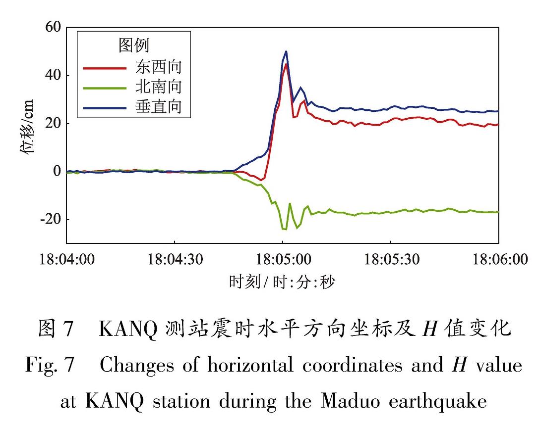
PGD可通过BDS/GPS融合PPP地震时间序列提取东西向、南北向的地震波形振幅后得到,计算公式为H=(E2+N2)1/2,E和N分别为东西向和南北向地震波形振幅。在实际应用中,可对BDS/GPS融合PPP地震时间序列每个历元的E和N作计算得到H值。图7以KANQ测站为例,计算了其各历元H值并提取PGD,得到PGD为50.17 cm。
图7 KANQ测站震时水平方向坐标及H值变化
Fig.7 Changes of horizontal coordinates and H value at KANQ station during the Maduo earthquake
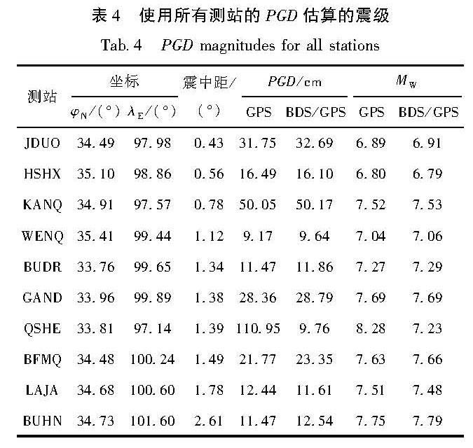
计算每个测站各历元H值并提取得到各测站的峰值地面位移后,可利用峰值地面位移PGD根据式(9)计算地震震级。本文利用所有测站峰值地面位移估计的震级见表4。
表4 使用所有测站的PGD估算的震级
Tab.4 PGD magnitudes for all stations
从表4中可以看出,由于QSHE测站GPS观测数据质量较差,利用其峰值地面位移计算得到震级为MW8.28,与GCMT公布的震级相比偏大,因此QSHE测站不参与后续各测站平均震级计算。对剩余9个测站GPS和BDS/GPS震级取平均值后,得到平均GPS震级为MW7.34,与GCMT公布的震级相差0.06; 平均BDS/GPS震级为MW7.36,与GCMT公布的震级相差0.04。从上可以看出,使用BDS/GPS比使用GPS峰值地面位移估算的震级更加接近公布震级。
利用峰值地面位移估算的震级呈现出方向性特征,震级在断层破裂扩展方向偏大,在非断层破裂扩展方向偏小。例如,距离震中最近的JDUO和HSHX测站,用GPS数据估算震级为MW6.89和MW6.8,用BDS/GPS数据估算震级为MW6.91和MW6.79,相比GCMT公布的震级MW7.4偏小; 在地震断层破裂扩展方向上的KANQ和GAND测站,用GPS数据估算震级为MW7.52和MW7.69、用BDS/GPS数据估算震级为MW7.53和MW7.69,比GCMT公布的震级偏大。笔者分析发现,这主要与地震断层破裂的方向性效应和地震波方向性效应有关。Somerville 等(1997)研究表明地震波传播方向与地震断层破裂方向夹角越小时,其地震动幅值越大。玛多地震为典型的左旋走滑型地震,其破裂沿昆仑山口—江错断裂展布长约160 km,其走向约为295°(王迪晋等,2022)。据此可以看出,位于昆仑山口—江错断裂及其延长线上的KANQ、GAND和BFMQ等测站具有更大的PGD值从而得到了偏大的震级,而远离昆仑山口—江错断裂及其延长线的WENQ、JDUO和HSHX等测站的PGD偏小,因此震级也偏小。从图6可以看出,此次获取的GNSS连续站大部分分布于断层破裂扩展方向两侧,因此用所有测站PGD估计的震级均偏小。
本文在利用PGD估算震级时,只考虑了测站震中距及地震时间序列的PGD,未考虑地震断层破裂的方向性效应与地震波方向性效应。且由于各测站所处地壳结构、基岩性质以及测站高度等影响,不同测站利用地震时间序列的PGD估算得到的震级与公布震级有微小的偏差。根据以上分析,为了用PGD估算得到更准确震级,克服地震断层破裂的方向性效应与地震波方向性效应以及不同测站的地壳地质差异影响,在估计震级时应尽量在震中周围均匀地选取尽可能多的测站进行估计,并采用多星座数据联合解算获取更真实的震时地表位移。