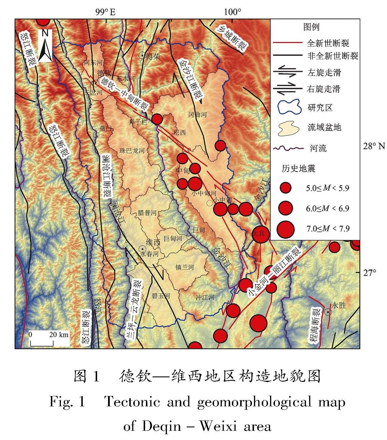
相互竞争的结果。地貌形态可能记录了不同尺度构造、气候和侵蚀过程变化的信息(张洁等,2016)。流域盆地的HI值对构造活动、岩性差异和气候变化等因素的反应比较敏感(邵崇建等,2015)。
4.1 降雨量
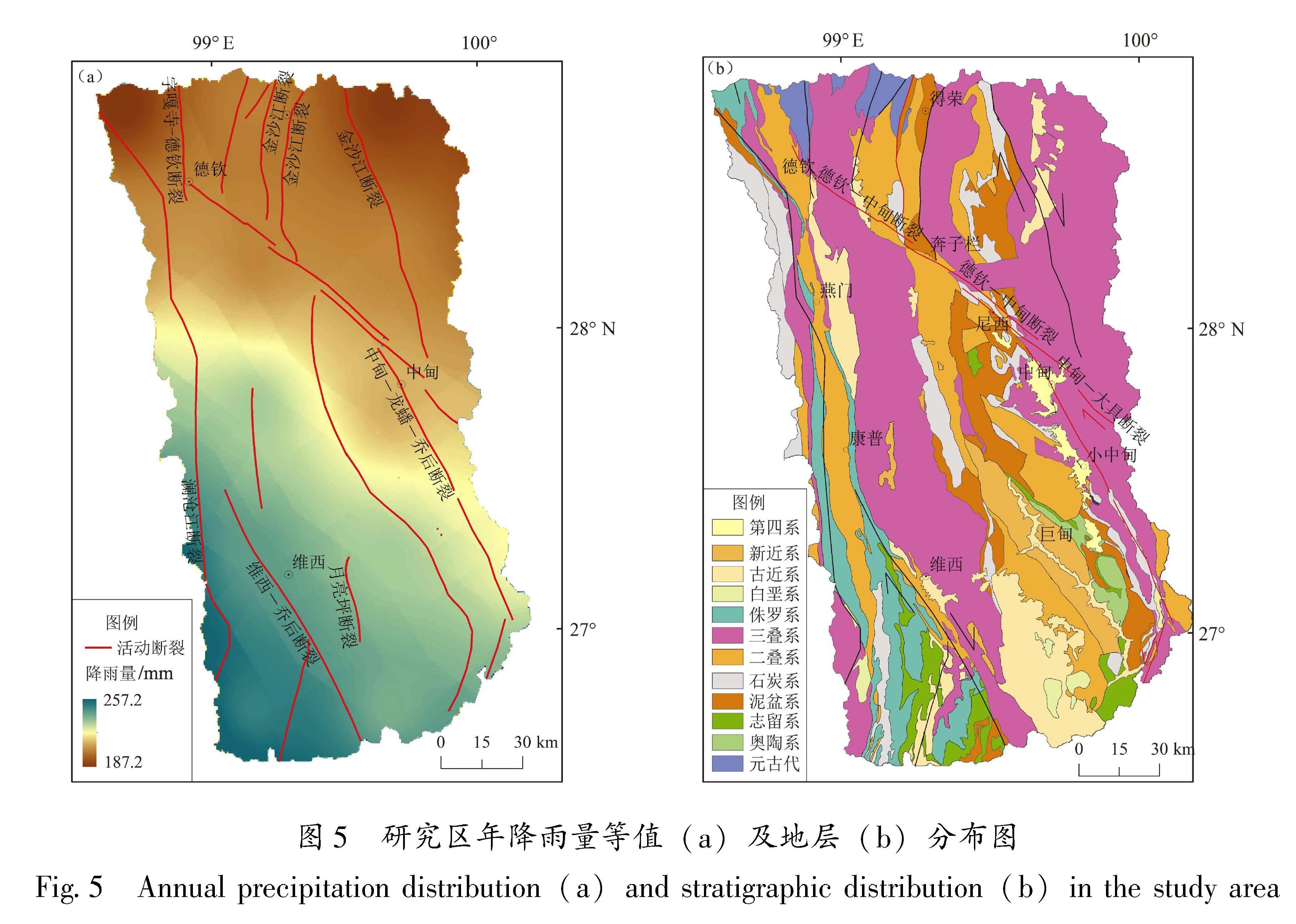
东英吉利大学气候研究单位(CRU)基于英国国家大气科学中心(NVAS)资助的合作中心NERC提供的高分辨率网格(0.5°×0.5°),制作了高分辨率气候逐月变化网格数据。本文选用分辨率为0.5°的CRU TS 4.05版降雨量数据,对研究区长达120年(1901—2020年)的降雨量数据进行空间插值,生成月均降雨量等值分布图(图5a)。
从图5a可以看出,研究区月均降雨量总体表
图5 研究区年降雨量等值(a)及地层(b)分布图
Fig.5 Annual precipitation distribution(a)and stratigraphic distribution(b)in the study area
现为由SW向NE递减的规律,降雨量等值分布图呈NW向近似条带状分布。但降水量的分布与HI值的分区并没有明显的相关关系。由此可见,气候不是研究区地貌的主控因素。
4.2 岩性
岩性也会通过剥蚀速率和河流侵蚀影响流域地貌演化(卢本添等,2022; 李环宇等,2020; 梁欧博等,2018)。抗侵蚀强的岩石可以阻止分水岭的迁移,而抗侵蚀弱的岩石则容易被河流下切和侧向侵蚀,形成准平原面(于洋等,2022)。研究区位于德钦—维西地层分区,各时代地层分布较齐全,自元古界至第四系均有出露(图5b),但广泛出露的为中生代陆相湖泊和河流相泥岩、泥质砂岩地层,部分地区有板岩、片岩、千枚岩等变质岩,局部见有煤系地层、石膏和灰岩(宋章等,2019)。
研究区北部,即德钦—中甸—大具断裂以北及其附近区域,大部分出露三叠系岩层,岩性以较坚硬的中厚层石英砂岩夹板岩、厚层碳酸岩或碳酸盐岩夹板岩组为主; 西北部零星分布有三叠纪和第三纪的火山岩; 研究区中部及以南地区,大范围分布有坚硬的中厚层-厚层砂岩或砂岩夹泥岩岩组,东南部夹有近南北呈条状分布的第四系黏土岩层和狭长分布的砂岩、泥岩夹灰岩岩组,少量零星分布有炭质页岩(王银龙,2019)。
总体来说,德钦—维西地区岩层质地较硬,整体的岩石抗侵蚀能力差别不大。因此,研究区的岩性并不是影响地貌演化的主控因素。
4.3 区域构造
前述讨论表明,降水和岩性均不是德钦—维西地区地貌演化的主控因素。因此,笔者认为研究区地貌演化主要受区域断裂差异抬升运动的控制,即德钦—维西地区流域盆地HI值与该区构造活动及其导致的隆升、沉降等地表过程密切相关。
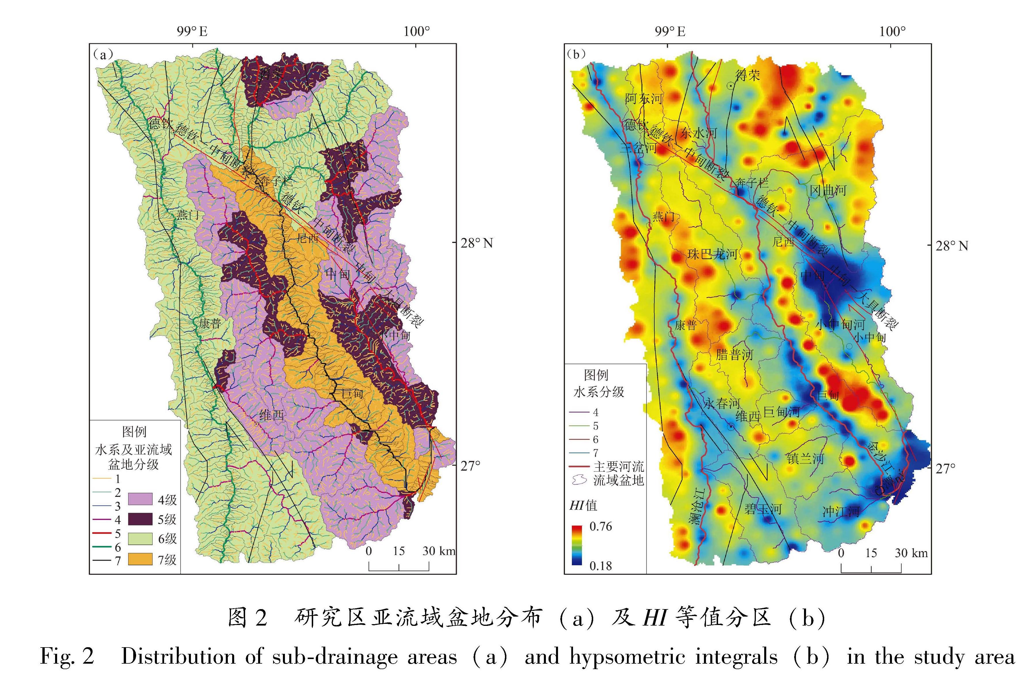
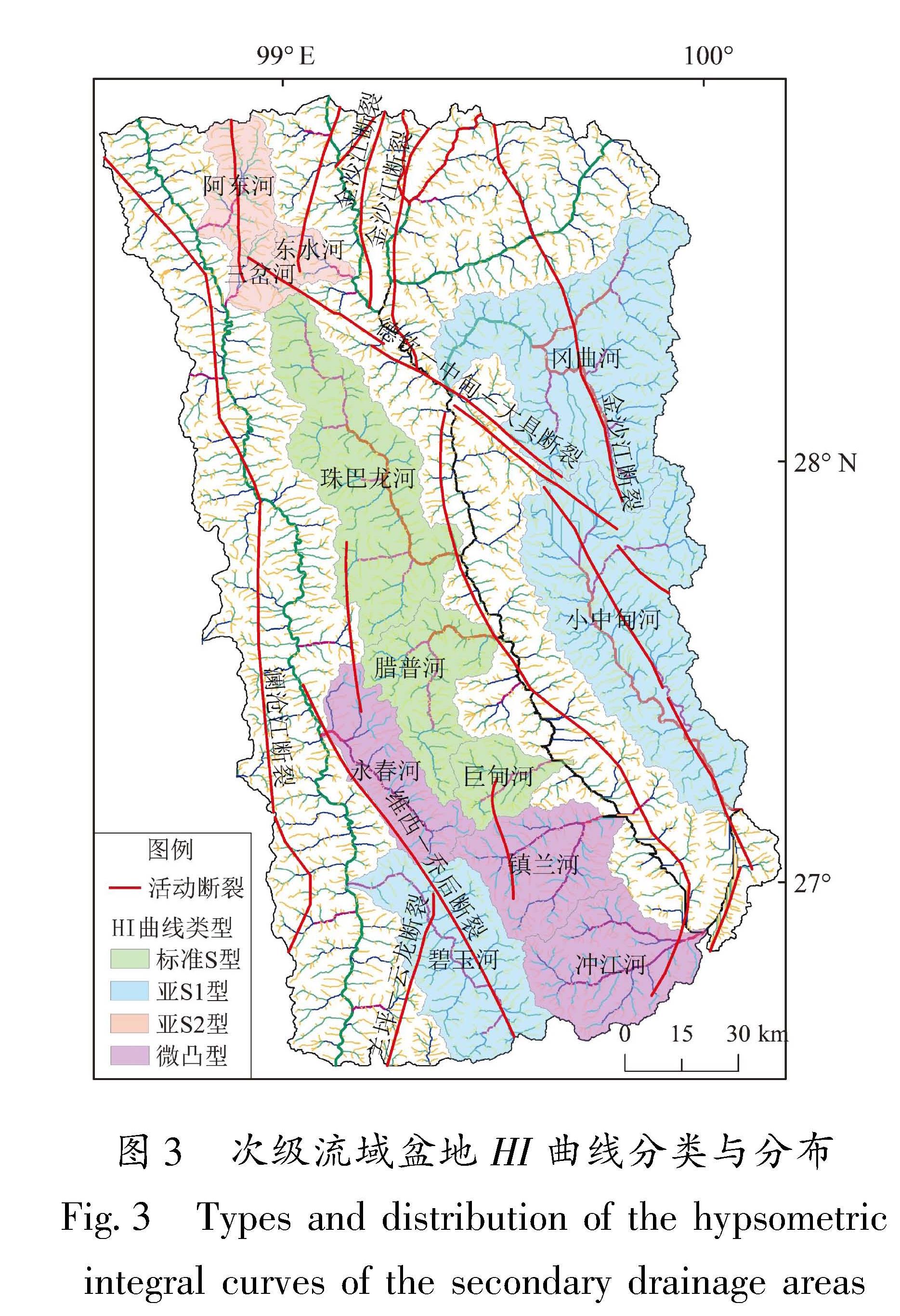
新生代以来,受板块碰撞引起的隆升作用影响,滇西北地区发生了差异性构造隆升,在整体隆升的同时,北部较南部隆升更剧烈,幅度也更大(李峰,薛传东,1999)。研究区内整体HI值表现为北高南低,北部德钦以北、得荣以东、维西—康普—燕门一线东侧为HI高值条带,这可能就是这种大尺度抬升作用的直接表现。阿东河、三岔河、东水河的流域盆地曲线的上凸形态,可能也是对区域抬升作用的响应。
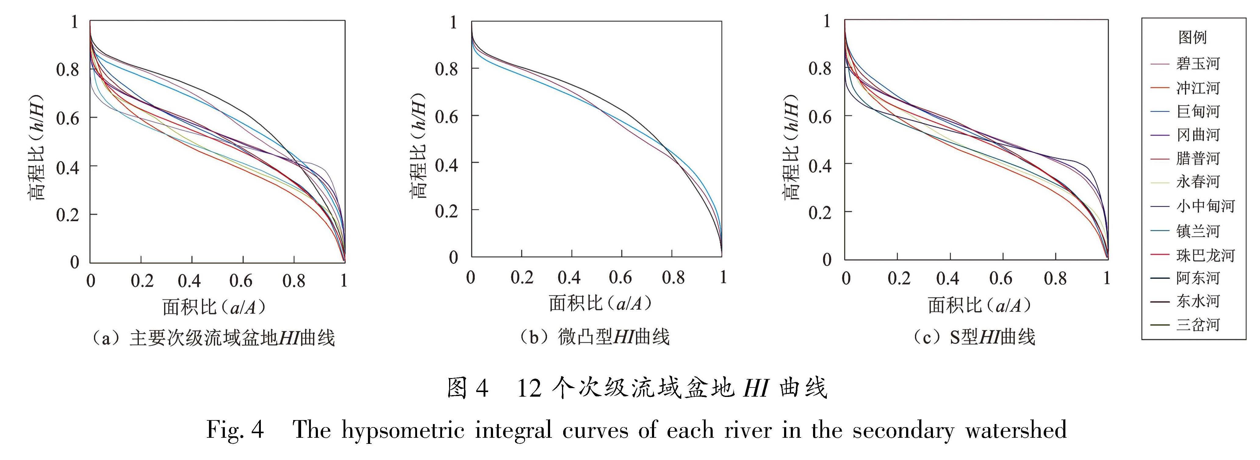
河流的冲刷下切作用形成了沿河流展布的HI低值区,并在河流的交汇口出现HI低值,如阿东河、三岔河与澜沧江的交汇处,北部金沙江支流与干流的交汇处,珠巴龙河、腊普河、镇兰河与金沙江的交汇处等。河流的交汇分布形成了山脊-河谷交错排列的地形结构。南部水系丰富,河流流域盆地的HI曲线图表现为S型,说明这些区域的地貌正处于侵蚀演化阶段。
德钦—中甸断裂以奔子栏为界分为两段(吴富峣等,2019b),北西段德钦—奔子栏段为HI高值区,南东段奔子栏—中甸段沿线HI值较低,说明德钦—中甸断裂以奔子栏为界,北西段与南东段的活动性存在差异,这与吴富峣等(2019b)的研究结果一致。
阿东河、东水河和三岔河3个处于幼年期的次级流域盆地均位于金沙江断裂与德钦—中甸断裂的交汇区域,说明该区地貌演化正处于构造隆升期,构造活动较强烈; 其南侧为珠巴龙河流域,断裂带附近的HI高值较南侧偏低,这与整体北高南低的地势不符,可能也是区域构造活动的结果。
小中甸以南、中甸—龙蟠—乔后断裂带与金沙江断裂夹持的区域存在一个突出的HI高值异常,而此处地势较研究区北部偏低。该异常揭示,受中甸—龙蟠—乔后断裂带与金沙江断裂活动的共同影响,该区构造活动强烈,地形地貌处于持续抬升状态,抬升速率大于剥蚀速率。同理,研究区南部的兰坪—云龙断裂与维西—乔后断裂北段交汇处具有较周围更高的HI值,这也是兰坪—云龙断裂与维西—乔后断裂北段活动的直接表现。
主要次级流域盆地中亚S1型和亚S2型HI曲线均属于被区域断裂截切的流域盆地的曲线,这也是研究区地貌演化受区域构造控制的直接证据。维西—乔后断裂、金沙江断裂和中甸—龙蟠—乔后断裂分别近平行穿切碧玉河、冈曲河和小中甸河3个次级流域盆地河谷地带,断裂带的活动直接影响了盆地的发育与演化,断裂带两侧河道差异抬升与沉降造成流域演化分异,相对抬升一侧处于幼年期,HI曲线凸起; 相对下降一侧处于老年期,HI曲线下凹,导致次级流域盆地HI曲线均表现为上凹下凸形态。亚S2型的冲江河、永春河和镇兰河次级流域盆地局部被区域断裂所截切,效果与亚S1型一致。