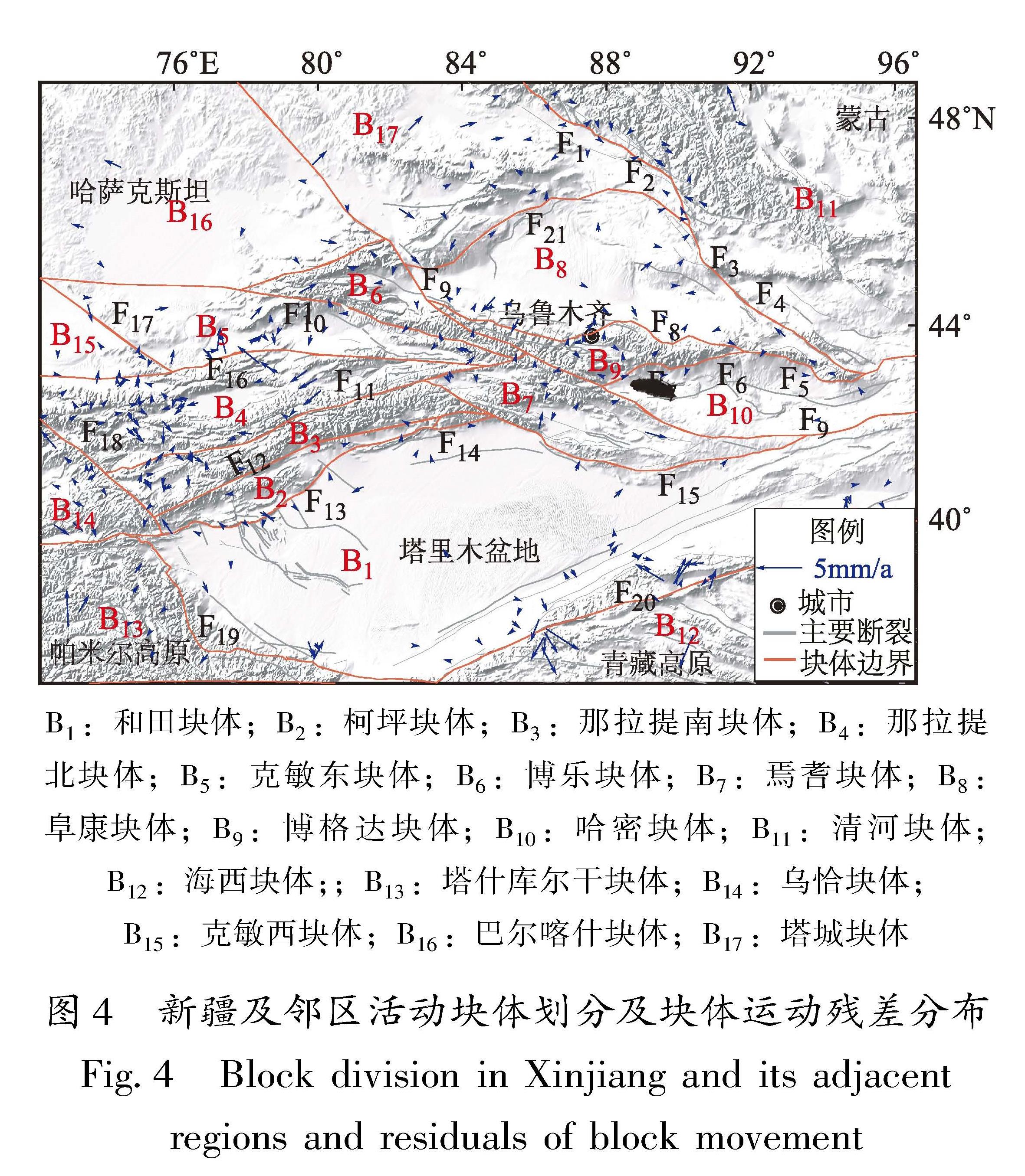
4.1 活动块体划分
基于活动块体的基本概念及划分原则,参考张培震等(2003b)的活动地块划分方案,综合区内主要活动断裂带和次级活动断裂带的空间展布、地震活动性等资料将新疆及邻区划分为17个活动块体等(图4)。基于刚性块体模型分析了各次级活动块体的稳定性,图4残差分布特征显示除帕米尔和阿尔金所在的青藏高原地区外,其他活动块体的稳定性较高,说明块体划分方案较为合理。[KG)]
图4 新疆及邻区活动块体划分及块体运动残差分布
Fig.4 Block division in Xinjiang and its adjacentregions and residuals of block movement
4.2 断层滑动速率与强震关系分析
本文基于Wang和Shen(2020)提供的GNSS速度场结果,利用Blocks程序(Meade,Loveless,2009),通过构建三维弹性块体模型反演了新疆及邻区活动块体边界断裂的滑动速率。断层闭锁深度对其周围弹性变形梯度有较大影响,当断裂的闭锁深度变化时,断层错动在地表各点引起的变化会有明显差异。获得断层闭锁深度的方法较多,本文在确定新疆及邻区断层闭锁深度时,没有对[JP2]每条断裂进行细分,而是利用了区域小震精定位结果(李金等,2015)和模型拟合(朱爽等,2021)两种方法综合给出最优闭锁深度。图5a为小震精定位结果,从图中不同震级地震的震源深度可见新疆地区地震以浅源地震为主,在南天山和帕米尔交汇区域有部分中源地震发生。跨南天山和北天山中东段的地震震源深度剖面(图5b、c)显示出新疆地区以浅源地震为主。图5d直方图结果显示跨南天山剖面震源深度不大于20 km的地震占比超过65%,跨北天山剖面震源深度不大于20 km的地震占比超过76%(图5e)。反演过程中通过多次试算得到GNSS数据拟合程度与断层闭锁深度的变化的关系,结果显示最优闭锁深度约为20 km(图5f),综上,断层滑动速率反演过程中新疆及邻区断层闭锁最优深度初值赋值20 km。考虑到大多数断层深部几何形态难以确定以及GNSS测站分布密度不够使得利用GNSS反演断层滑动速率时断层深部的影响不敏感,因此本文利用Blocks程序反演断层滑动速率过程中假设块体边界断层面均为直立产状。
图5 天山地区小震精定位分布(a)、跨南天山(b)和北天山(c)中东段震源深度剖面、南天山(d)和北天山(e)震源深度频次统计结果,以及最优闭锁深度(f)
Fig.5 Smallearthquake epicenters in the Tianshan Mountains after relocation(a),focal depth profiles across the middle and east part of the South Tianshan Mountains(b)and the Nouth Tianshan Mountains(c),frequency of the focal depth in the South Tianshan Mountains(d)and in the Nouth Tianshan Mountains(e),and the optimal locking depth(f)[HT]
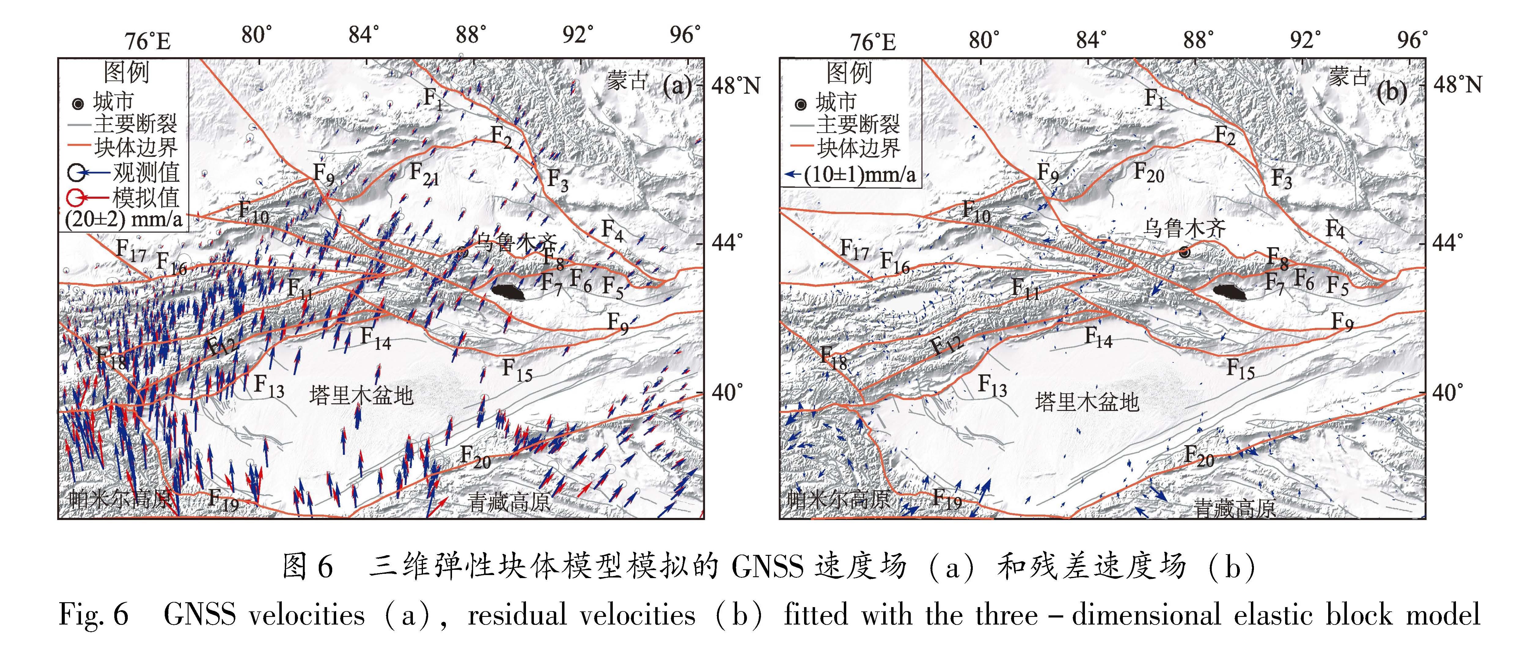
图6 三维弹性块体模型模拟的GNSS速度场(a)和残差速度场(b)
Fig.6 GNSS velocities(a),residual velocities(b)fitted with the three-dimensional elastic block model
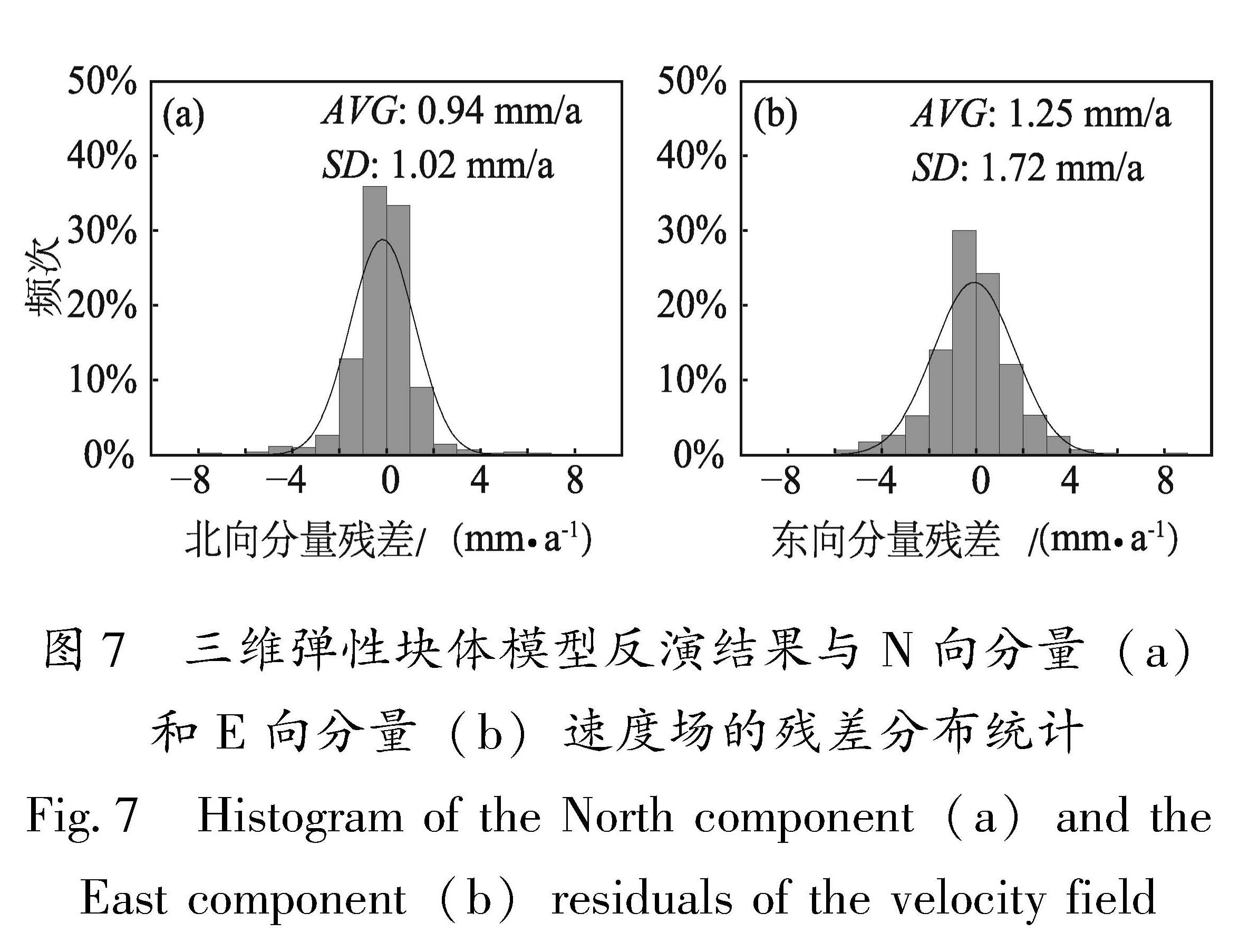
图6a为模拟得到的GNSS速度场与观测速度场较为吻合,较大的残差主要位于帕米尔、青藏高原等观测误差较大的地区(图6b)。残差分布的直方图(图7)表明北方向和东方向残差平均值分别为-0.16和0.08 mm/a;图中 AVG、SD 分别为残差绝对值的均值和标准差。残差绝对值均值分别为0.94和1.25 mm/a,标准差分别为1.02和1.72 mm/a,残差主要集中在±2 mm/a之间,服从正态分布,说明反演结果较为可靠。
图7 三维弹性块体模型反演结果与N向分量(a)和E向分量(b)速度场的残差分布统计
Fig.7 Histogram of the North component(a)and the East component(b)residuals of the velocity field
图8为基于GNSS数据利用三维弹性块体模型给出新疆及邻区的断层运动以及1976年以来区域内 M ≥6.0地震的震源机制解分布。从图中可以看出:新疆及邻区NW走向的断裂红色为左旋,蓝色为右旋,其中以右旋走滑运动为主,如准噶尔盆地北东侧的额尔齐斯断裂带和可可托海—二台断裂带;中天山地区的博阿断裂、喀什河断裂; 南天山西段的塔拉斯—费尔干纳断裂带和大扎莱尔断裂带等。NE走向的断裂带以左旋走滑运动为主,如准噶尔盆地北缘的达尔布特断裂带、准噶尔盆地南缘的博格达北缘断裂带、博格达南缘断裂带;塔里木盆地南北两侧的阿尔金断裂带、那拉提断裂带、迈丹断裂带、柯坪断裂带以及兴地断裂带等。新疆天山地区的断裂带表现出明显的挤压特征,其中以南天山西段的乌孙山山脊断裂、那拉提断裂西段、迈丹断裂东段和柯坪断裂中西段最为显著。
阿尔金断裂是青藏高原和塔里木盆地交汇地区的边界断裂,李煜航等(2015)基于1999—2013年GPS水平速度场,使用三维线弹性球面块体模型给出阿尔金断裂的滑动速率约为8 mm/a;王阎昭和王敏(2020)通过对多种资料综合分析给出阿尔金断裂中西段滑动速率为10±3 mm/a,上述结果与本文给出(9.1±2.0)mm/a(图8)的结果较为一致。博阿断裂是划分准噶尔—北天山褶皱系于天山褶皱系的分界断裂,也称天山主干断裂,被认为是一条板块聚合的边界,本文模型反演结果显示断裂带右旋走滑速率存在明显的自西向东衰减的特征,断裂带西段滑动速率为(5.3±1.7)mm/a,中段为(1.5±1.7)mm/a,最东端为(0.9±0.8)mm/a;马建和吴国栋[JP2](2019)基于构造地貌和光释光测年结果给出断裂中东段滑动速率为(1.42±0.18)mm/a;李桂荣等(2016)基于GNSS资料的分析认[JP2]为博阿断裂西段滑动速率为4.8 mm/a,东段滑动速率约为1.1 mm/a,
图8 新疆及邻区主要断裂走滑[KG0](a)、张压(b)特征和震源机制分布
Fig.8 Strike-slip(a),tension and pressure(b)characteristics of major faults andfocal mechanism distribution in Xinjiang and its adjacent regions
上述结果与本文模型反演结果基本一致。南天山西段研究程度较高的为柯坪断裂,该断裂带位于天山南部、塔里木盆地西北部,是新生代印度板块和欧亚板块持续碰撞的产物(Allen et al,1999),新生代以来柯坪推覆系东西向缩短量约35~40 km(杨晓平等,2006;刘华国,2011)。由于变形开始时间的不确定,缩短速率有较大差异,一种认为变形开始于20 Ma,缩短速率为2 mm/a(Allen et al,1999);另一种认为变形开始于西域砾岩沉积时期约为2.5 Ma,缩短速率约为15 mm/a(杨晓平等,2006),GNSS给出的变形速率为10~20 mm/a(王琪等,2000;王晓强等,2005)。本文模型反演结果显示柯坪断裂以挤压运动为主,自西向东挤压速率分别为(9.9±1.5)mm/a,(13.9±0.8)mm/a,(4.8±1.0)mm/a和(1.5±0.8)mm/a,断裂西段的挤压速率与杨晓平等(2006)以及基于GNSS给出的结果(王琪等,2000;王晓强等,2005)较为一致。
由于断层运动及震源机制解数据都能反映构造和动力背景,因此对断层滑动和震源机制进行比较是有意义的。总的来说,本文反演的断层运动的方式与新疆及邻区的震源机制类型基本是一致的,如以走滑运动为主的阿尔金断裂带,沿断裂带发生的地震表现出走滑特征。以南北向逆冲挤压为主要运动特征的柯坪断裂带上的地震以逆冲类型为主。新疆及邻区近几十年的强震(图8)主要集中分布在南天山西段与帕米尔西构造结东部附近,一系列NE走向断裂和NW走向断裂相交于此,使得该区域构造活动十分复杂,强震频发。

 为经典平差问题需要求解的待定参数;Z^为随机信号估值(包括观测点和推估点);G为经典平差问题的系数阵;DX为已测点信号的协方差阵;D Δ 为观测值的协方差阵;L为观测值;DZ 为所有点信号的协方差阵。

 代表块体内部的弹性应变张量;VB块体整体运动速度;VCSD为块体边界断裂在块体之间相对差异运动时由于断层闭锁作用产生的同震亏损滑动速率;Vε[DD(-*3]·[DD)] 为块体之间的内部均匀弹性变形对速度场的贡献。
![图5 天山地区小震精定位分布(a)、跨南天山(b)和北天山(c)中东段震源深度剖面、南天山(d)和北天山(e)震源深度频次统计结果,以及最优闭锁深度(f)<br/>Fig.5 Smallearthquake epicenters in the Tianshan Mountains after relocation(a),focal depth profiles across the middle and east part of the South Tianshan Mountains(b)and the Nouth Tianshan Mountains(c),frequency of the focal depth in the South Tianshan Mountains(d)and in the Nouth Tianshan Mountains(e),and the optimal locking depth(f)[HT]](2024年03期/pic71.jpg)
、张压(b)特征和震源机制分布<br/>Fig.8 Strike-slip(a),tension and pressure(b)characteristics of major faults andfocal mechanism distribution in Xinjiang and its adjacent regions](2024年03期/pic74.jpg)