基金项目:国家自然科学基金(41790462,41804059,41904084,41561164018).
第一作者简介:张 博(1990-),讲师,主要从事微震检测、地震定位及地震活动性相关教学科研工作.E-mail:zhangbo199011@163.com.
(1.中国地震局地球物理研究所,北京 100081; 2.中国科学技术大学 地球和空间科学学院,安徽 合肥 230026; 3.中国科学技术大学 安徽蒙城地球物理国家野外科学观测研究站,安徽 合肥 230026; 4.新疆维吾尔自治区地震局,新疆 乌鲁木齐 830011; 5.中国地震局 乌鲁木齐中亚地震研究所,新疆 乌鲁木齐 830011; 6.防灾科技学院 地球科学学院,河北 三河 065201)
(1.Institute of Geophysics,China Earthquake Administration,Beijing 100081,China)(2.School of Earth and Space Sciences,University of Science and Technology of China,Hefei 230026,Anhui,China)(3.Mengcheng National Geophysical Observatory,University of Science and Technology of China,Hefei 230026,Anhui,China)(4.Earthquake Agency of Xinjiang Uygur Autonomous Region,Urumqi 830011,Xinjiang,China)(5.Urumqi Institute of Central Asia Earthquake,China Earthquake Administration,Urumqi 830011,Xinjiang,China)(6.School of Earth Sciences,Institute of Disaster Prevention,Sanhe 065201,Hebei,China)
the Nurga Reservoir; micro-earthquake detection; waveform cross-correlation; earthquake location; seismicity
DOI: 10.20015/j.cnki.ISSN1000-0666.2024.0056
随着水库在世界各地兴建,人们陆续在多个水库库区附近观测到与蓄水过程相关的破坏性地震(Gupta,2002; McGarr et al,2002),地震学研究中采用水库触发地震来描述这类特殊的地震活动。全球范围内已有超过150余例水库触发地震的报道,其中40余例位于中国大陆地区(蒋海昆等,2014)。国内水库触发地震的报道主要集中在黄河以南地区,以西南、华东、华南地区居多,分布于不同的地质构造带。天山区域是我国构造活动强烈的地质构造带之一(张培震等,2003; 张国民等,2005),区域内常有6级以上破坏性地震活动。但在天山区域却少有水库诱发地震的报道,仅有的两个案例是位于南天山的克孜尔水库1993年M4.4地震、2005年M5.3地震和恰普其海2006年M4.6地震(蒋海昆等,2014)。对于北天山区域水库蓄水对区域地震活动影响的研究相对较少。
2015年1月位于北天山北坡中段的努尔加水库建成蓄水,这是一座兼具供水、防洪、灌溉三大功能的控制性水利枢纽工程,总设计库容为6 844万m3,控制流域面积近8 000万m2,属于Ⅲ等中型水库(王永涛,2011)。水库位于三屯河流域的中低山区,距上游三屯河水库17 km,距下游西干渠首7.3 km。在运行的第二年(2016年)库区附近出现一系列地震活动,引起关注。开展努尔加水库地震活动性的观测研究为我们提供了一个进一步讨论在北天山区域水库蓄水与库区周边地震活动关系的良好机会。
本文对努尔加水库蓄水前后库区周边地震活动的时空演化特征进行分析,讨论水库蓄水对库区周边地震活动的影响。采用模版匹配滤波(Peng,Zhao,2009; Meng et al,2012)及基于波形互相关的地震定位技术(Yang et al,2009)来完善水库蓄水前1年、后4年库区周边的地震目录。通过分析努尔加水库地震活动的时空演化特征,结合区域地质构造背景及水库蓄水过程,讨论努尔加水库库区周边地震活动的发震机制以及水库蓄水对库区周边地震活动的影响。
天山是远离板块边界的大陆内部山系,新生代以来受到强烈的挤压和隆升等构造变形作用,形成了欧亚大陆内部再生造山带(邓起东等,1999; 张培震等,2003; 张国民等,2005)。北天山区域近水平沿NNE向的最大主压应力,受到博格达山和博罗科努山堆积造成的挤压隆升影响,以东经87°为界发生偏转,偏转角度约9°(李艳永等,2018)。在近南北向的强烈挤压作用下,天山南、北山前地区发育了多个凹陷盆地(杨晓平等,2008)。在天山北麓发育了两个不同类型的逆断裂-褶皱构造,分别为乌鲁木齐以西的北天山山前逆断裂-背斜活动构造系和乌鲁木齐以东的博格达逆冲推覆构造系(汪一鹏,沈军,2000; 陈立春,2011)。北天山主要构造及历史地震如图1a所示。
努尔加水库地处北天山北麓中段,临近构造活动较为活跃的天山地区。努尔加水库库区(86.98°~87.07°E,43.80°~43.87°N)位于上述两构造系之间,昌吉背斜北翼与喀拉扎背斜交汇处(张子凤,2014)。距离库区10 km范围内发育有两条北倾的逆断层(陈伟等,2010),分别为昌吉断裂(图1b,F1)和喀拉扎断裂(图1b,F2)。其南部为南准噶尔断裂(图1b),北天山区域历史上记录到的最大地震为玛纳斯7.7级地震(顾功叙,1984)和2016年12月8日的呼图壁MS6.2地震(Gong et al,2019; Wang et al,2019),都被认为与此断层相关。库区基底基岩岩性由巨厚层状的砂砾岩、砾岩组成,其中夹含砾泥质砂岩透镜体,地层产状倾向下游(270°~280°NE∠29°~30°)。
努尔加水库的选址地三屯河是一条雨雪混合补给的山溪性中小型内陆河,发源于天山北坡
中段的天格尔峰,跨越高、中、低山带,出山口后进入平原灌溉区,最终消失于沙漠中(张婉君,2020)。三屯河径流量年际变化平稳,多年平均年径流量为3.55亿m3,是北天山中段径流量最大的河流,但是年内径流分布极度不均匀,季节性和月径流变化较大,来水量主要集中在6~9月,径流量为2.77亿m3,约占全年来水量的78%(陈俊仁,2017),致使库区水位呈现大幅度的周期性年变化。
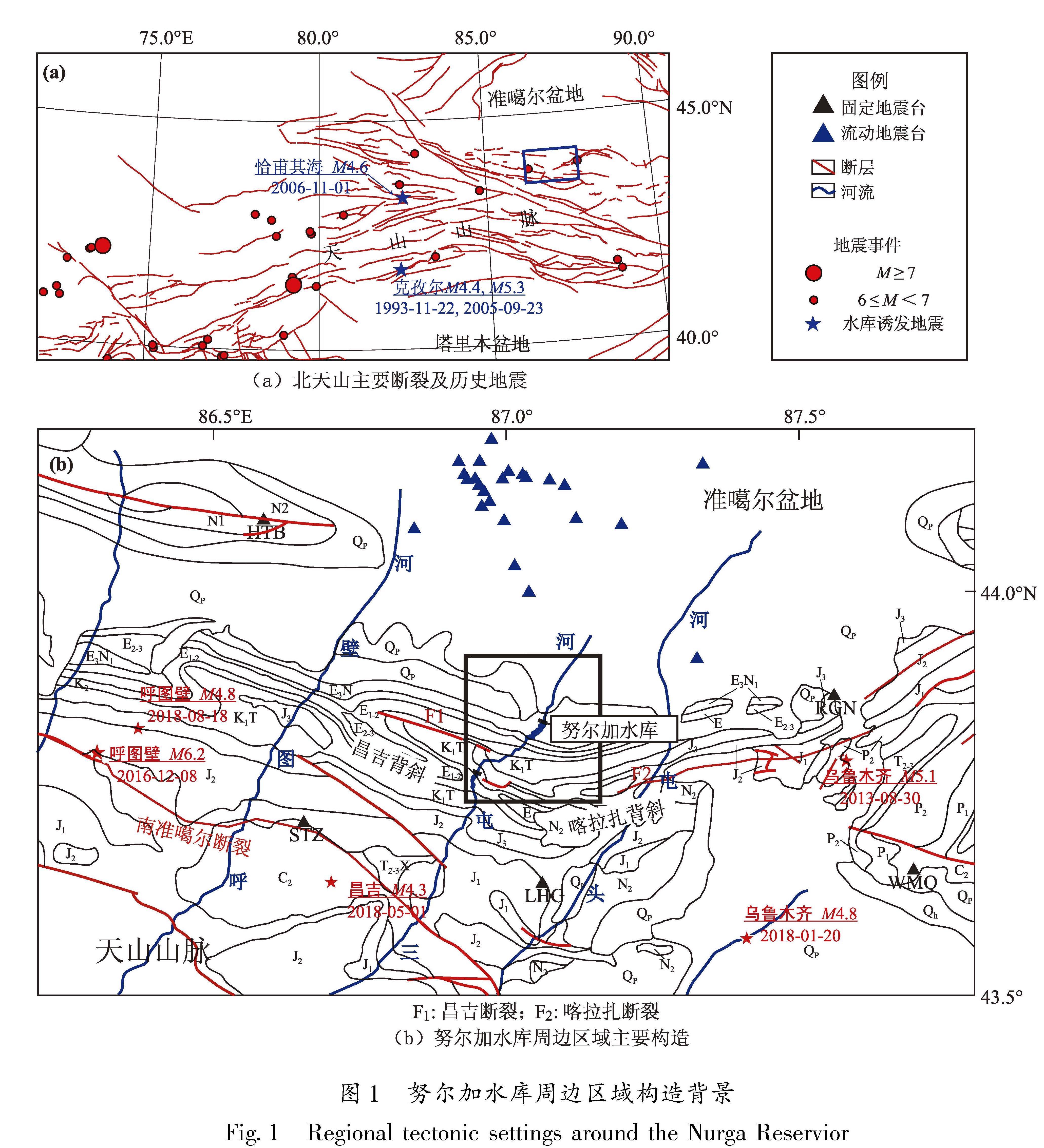
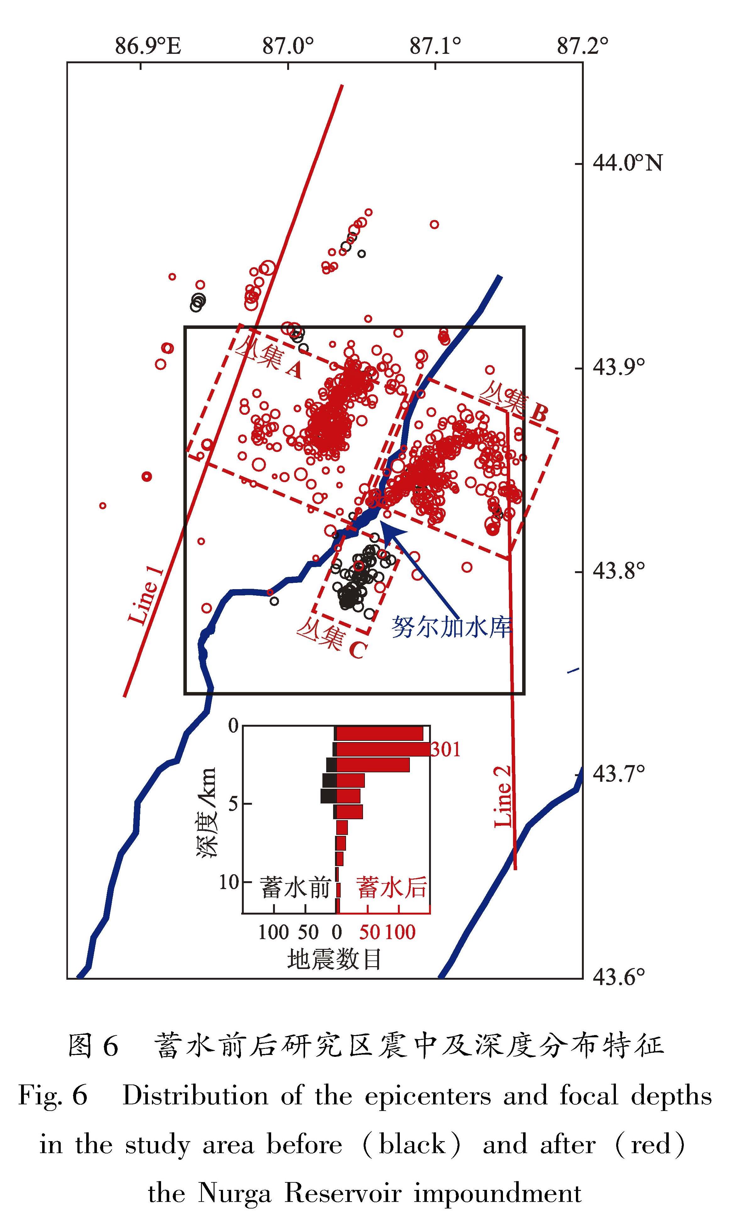
水库蓄水对周边地震活动的影响通常集中在库区附近约10 km内,因此,我们将研究区域限定为努尔加水库库区周边10 km以内的范围(图1b中的黑色框)。
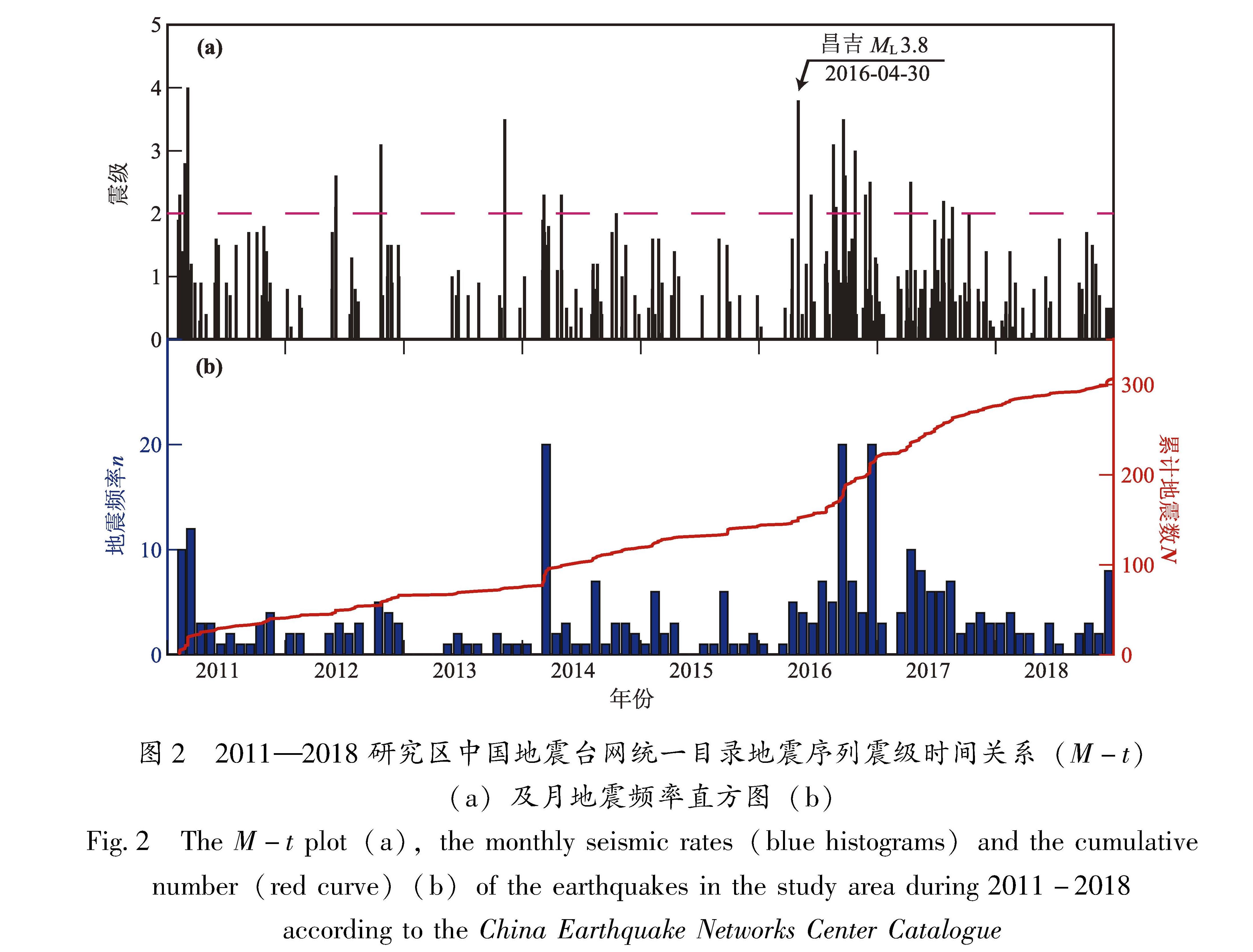
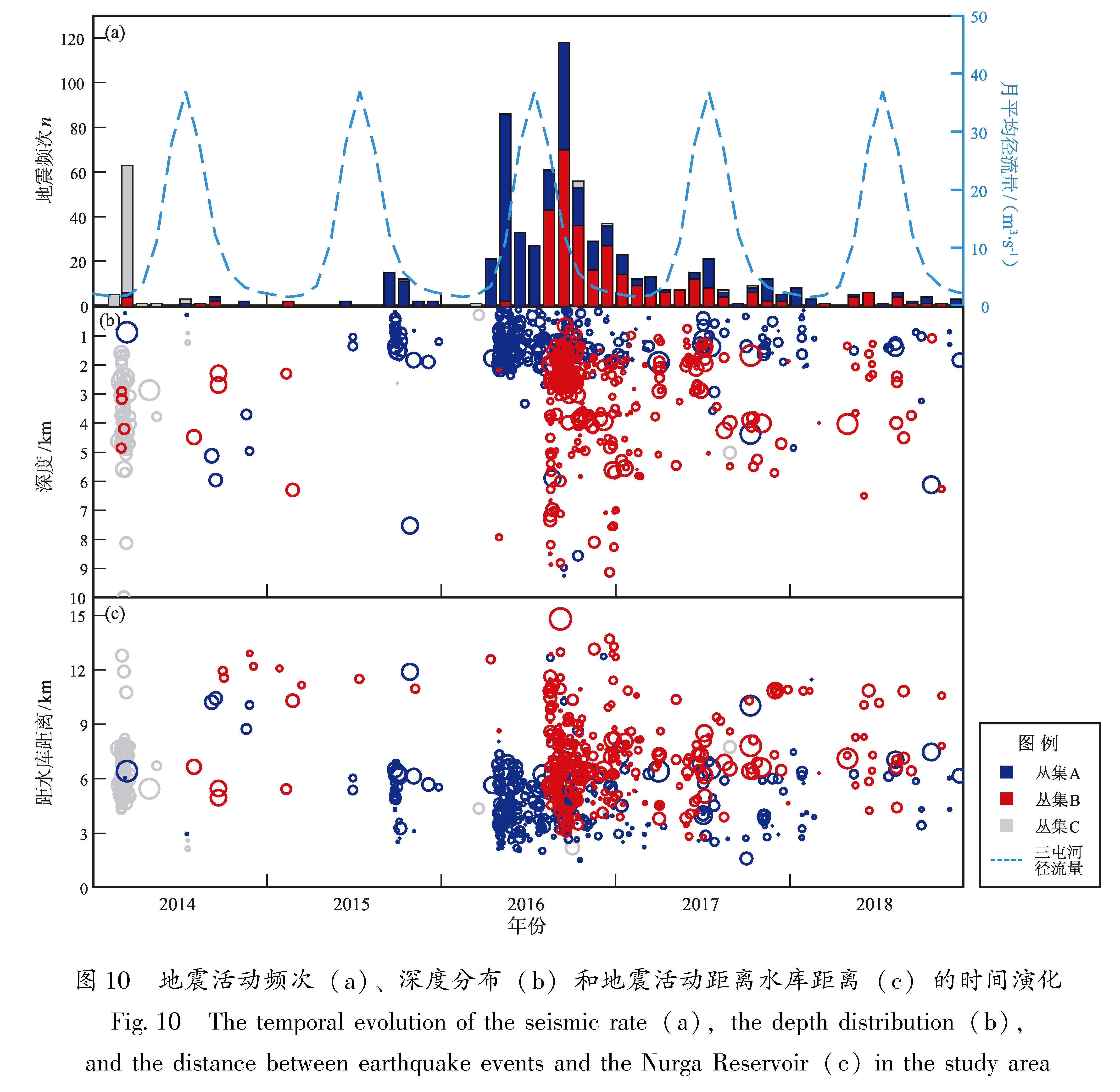
由中国地震台网统一目录(以下简称台网目录)可见,研究区域内水库蓄水前(2011—2014年)库区附近的地震活动并不强烈,2级以上地震平均约2.7次/年,而在蓄水后的第二年(2016年)共发生10次2级以上地震(图2)。尤其是在三屯河汛期(4—10月)接连发生4次3级以上
图2 2011—2018研究区中国地震台网统一目录地震序列震级时间关系(M-t)(a)及月地震频率直方图(b)
Fig.2 The M-t plot(a),the monthly seismic rates(blue histograms)and the cumulative number(red curve)(b)of the earthquakes in the study area during 2011-2018 according to the China Earthquake Networks Center Catalogue
地震,其中最大地震事件发生在4月30日,震级为ML3.8,是2011年以来最大的地震事件(图2)。其后,地震活动逐渐减弱,并在2018年逐步恢复至水库蓄水之前的水平。因此,本文选取2014年1月至2018年12月的数据,期间台网目录共记录到271次地震事件。
由于北天山区域地质构造复杂(邓起东等,1999; 杨晓平等,2008),库区周边固定地震台站分布较为稀疏,距离库区100 km以内仅有5个固定地震台,这些因素可能会导致目录构建过程中大量地震事件被遗漏、因台网目录,基于单事件法震源位置确定存在偏差等,进而影响地震活动性分析的可靠性。
收集库区100 km以内的固定地震台网(图1b中黑色三角形)及“呼图壁计划”(Ji et al,2021; Zhang et al,2022)架设的流动地震台网(图1b中蓝色三角形)观测数据,采样频率均为100 Hz。流动地震台网的观测开始于2013年6月,在研究时窗内分阶段先后布设了30个流动观测台站,有效弥补了地震观测系统在库区北侧的缺失(图1b)。
目前以波形互相关技术为基础的模板匹配滤波技术是一种低信噪比下检测遗漏地震事件的有效方法(Peng,Zhao,2009; Meng et al,2012)。该方法以震相清晰的地震事件作为模板,利用波形相关性,扫描连续波形数据,寻找与模板事件波形相似度高的一段连续波形,作为新检测事件,实现对微弱地震事件的自动识别和检测。其对具有相似发震机理且传播路径相近的地震事件具有很好的检测效果,已经应用于地脉动检测、余震序列变化以及确定发震构造等方面(Shelly et al,2007; Peng,Zhao,2009; Yang et al,2009; 侯金欣,王宝善,2017)。
相较于单事件定位,双差定位方法(HypoDD)可以一定程度减小由于地壳复杂性而引起的误差,随后发展出的波形互相关技术可以被应用于震相的到时差的计算(Yang et al,2009),大大提高了到时差拾取精度,进而提高地震定位精度(黄媛等,2006; Waldhauser,Schaff,2008)。基于波形互相关技术的双差定位方法(Waldhauser,Ellsworth,2000),可以有效构建区域地震目录,并且有助于地震学家更为详尽地刻画地震丛集发震构造、分析地震活动的时空演化特征、讨论地震序列的成因(易桂喜等,2017)。这种方法一方面可以提高模板事件的定位精度,另一方面可以高效的确定检测事件的空间分布(侯金欣,王宝善,2017)。
本文首先对2013—2018年研究区域内超过4个台站(包含固定地震台站和流动地震台站)记录的223个地震事件进行重定位。重定位所采用的速度模型为Sun等(2012)校正的适用于北天山区域的一维速度模型。
台网目录事件的重定位先利用Hypoinverse方法(Klein,2002)进行单个事件的绝对定位,初步确定震源位置,再利用双差定位方法(Waldhauser,Ellsworth,2000)进行相对定位,获得更为精确的定位结果。绝对定位采用人工拾取的2 709条P波和2 256条S波的到时数据; 相对定位采用的事件对震相走时差则利用互相关技术提取获得。走时差的计算遵循Yang等(2009)提出的方法:首先对波形记录进行2~8 Hz的带通滤波提高信噪比,然后截取时窗长度为2 s的P波(即人工拾取的P波到达前0.5 s,到达后1.5 s)和时窗长度为3 s的S波(即人工拾取的S波到达前1 s,到达后2 s)震相进行互相关计算。选取互相关系数最高的结果计算事件对震相走时差,对应的互相关系数则为该事件对对应震相走时差的权重系数。以0.4为阈值,互相关系数低于0.4的震相对则以人工标记到时计算震相走时差。最终,获得了95 328个P波和 80 268个S波走时差。
利用双差定位方法进一步确定了132个地震事件的震源位置,占实际参与定位的地震数目的56%,没有进行双差定位的事件则采用绝对定位的结果。走时残差由重定位前2.059 s下降到定位后的0.469 s。根据重定位的位置重新测定了地震震级,震级的测定采用新的震级国家标准《地震震级的规定》(GB 17740—2017)所规定的地方性震级ML的测定方法(刘瑞丰等,2018)。
为了克服流动台站记录质量变化对微震检测造成的影响,使用来自5个观测质量较好的固定台站的连续数据。微震检测的过程遵循Peng等(2009)的分析方法,采用Meng等(2012)改进的基于GPU加速的程序提高计算效率。具体步骤如下:
(1)对连续波形数据进行预处理:去波形尖灭、去均值、去线性趋势,并进行2~8 Hz带通滤波,提高信噪比。
(2)对重定位的台网目录进行筛选,选择重定位与区域内且至少具有9个信噪比大于3的固定地震台站信道清晰记录的174个地震事件作为模板事件。
(3)计算每个模板和连续波形之间的滑动窗口互相关系数(cross-correlations,CC):
式中:t0和t1分别是要用于计算CC值的信号窗口的起止时刻; X(t)和Y(t)分别是在t0和t1时间段内的模板事件波形和连续波形。计算过程中每次在连续波形上移动一个采样点。分别设置CC值的计算的时间窗口为垂直分量的P波和两个水平分量的S波到达之前1 s和之后3 s。
(4)根据模板事件震相到时计算不同台站的CC值,然后取平均值。
(5)平均CC值大于0.35且大于CC值波列的绝对离散中位数15倍的波形被视为潜在检测事件。为了尽量减少可能的重复检测,我们只在 2 s的时间窗口内保留最大CC对值应的波形作为检测事件(Meng et al,2012)。
(6)检测事件的发震时刻由其模板事件的震相走时确定; 检测事件的震级由其所对应的模板事件的水平分量的S波到时前2 s到后2 s内最大振幅的比值,计算两个水平分量的振幅比的平均值来确定(Meng et al,2012)。
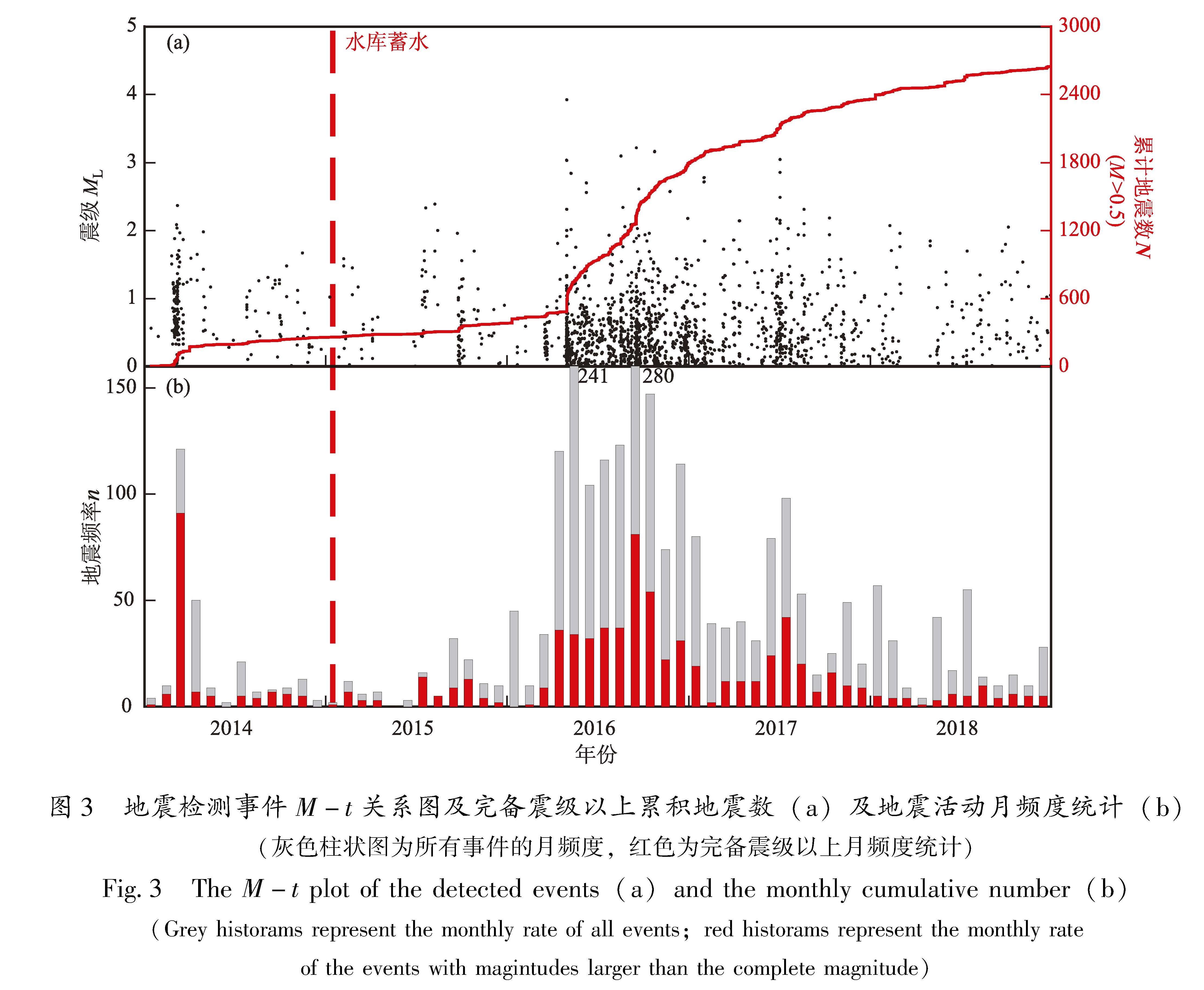
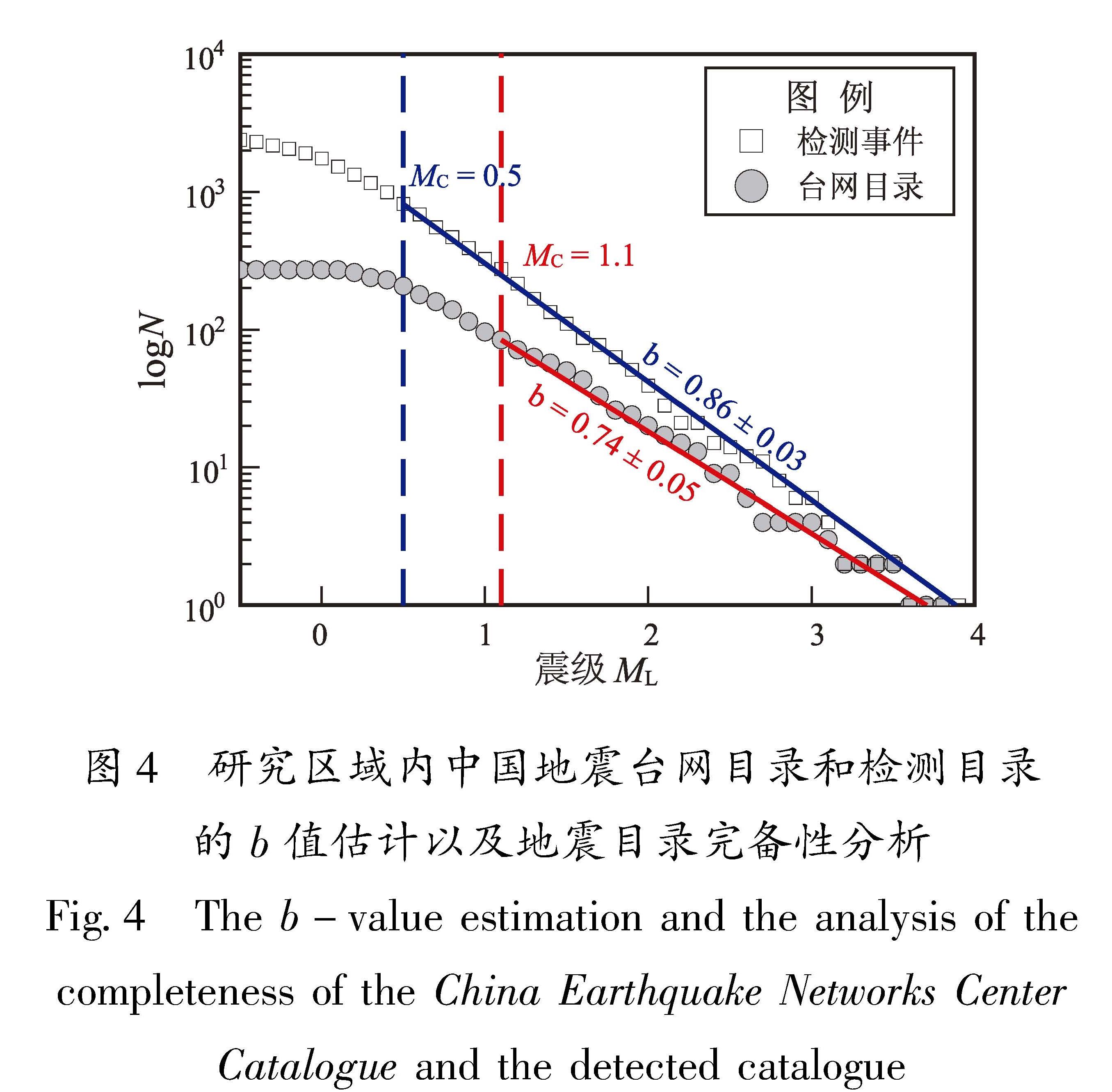
从2014年1月1日到2018年12月31日,研究区总共检测到2649个地震事件(图3), 近10倍于中国地震台网目录中记录的相同区域和时间段的271个事件。为了确定地震因素的完整性,使用ZMAP(Wiemer,Wyss,2000; Wiemer,2001)进行Gutenberg-Richter关系的拟合。微震检测将台网目录的完备震级(MC)由检测前的1.1降低至0.5,检测目录的b值为0.86(图4)。
图3 地震检测事件M-t关系图及完备震级以上累积地震数(a)及地震活动月频度统计(b)(灰色柱状图为所有事件的月频度,红色为完备震级以上月频度统计)
Fig.3 The M-t plot of the detected events(a)and the monthly cumulative number(b)(Grey historams represent the monthly rate of all events; red historams represent the monthly rate of the events with magintudes larger than the complete magnitude)
在利用模板匹配滤波进行遗漏事件检测的基 础上,利用基于波形互相关的双差定位方法(Yang et al,2009)可以实现对检测事件的地震定
图4 研究区域内中国地震台网目录和检测目录的b值估计以及地震目录完备性分析
Fig.4 The b-value estimation and the analysis of the completeness of the China Earthquake Networks Center Catalogue and the detected catalogue
位(侯金欣,王宝善,2017)。检测事件定位过程中,首先设置检测事件的初始位置为其对应的模板的位置。事件对的P波及S波的走时差通过波形互相关获得,并采用与台网目录精定位过程中使用的相同的P波及S波时窗窗长及互相关阈值。为了保证定位结果的准确性及稳定性,定位过程中加入流动台数据以加强约束,并且只选择震相数据丰富且具有强关联性的地震对进行定位。将最小震相数目设置为8,这使得我们失去了许多未能得到强关联性的地震。
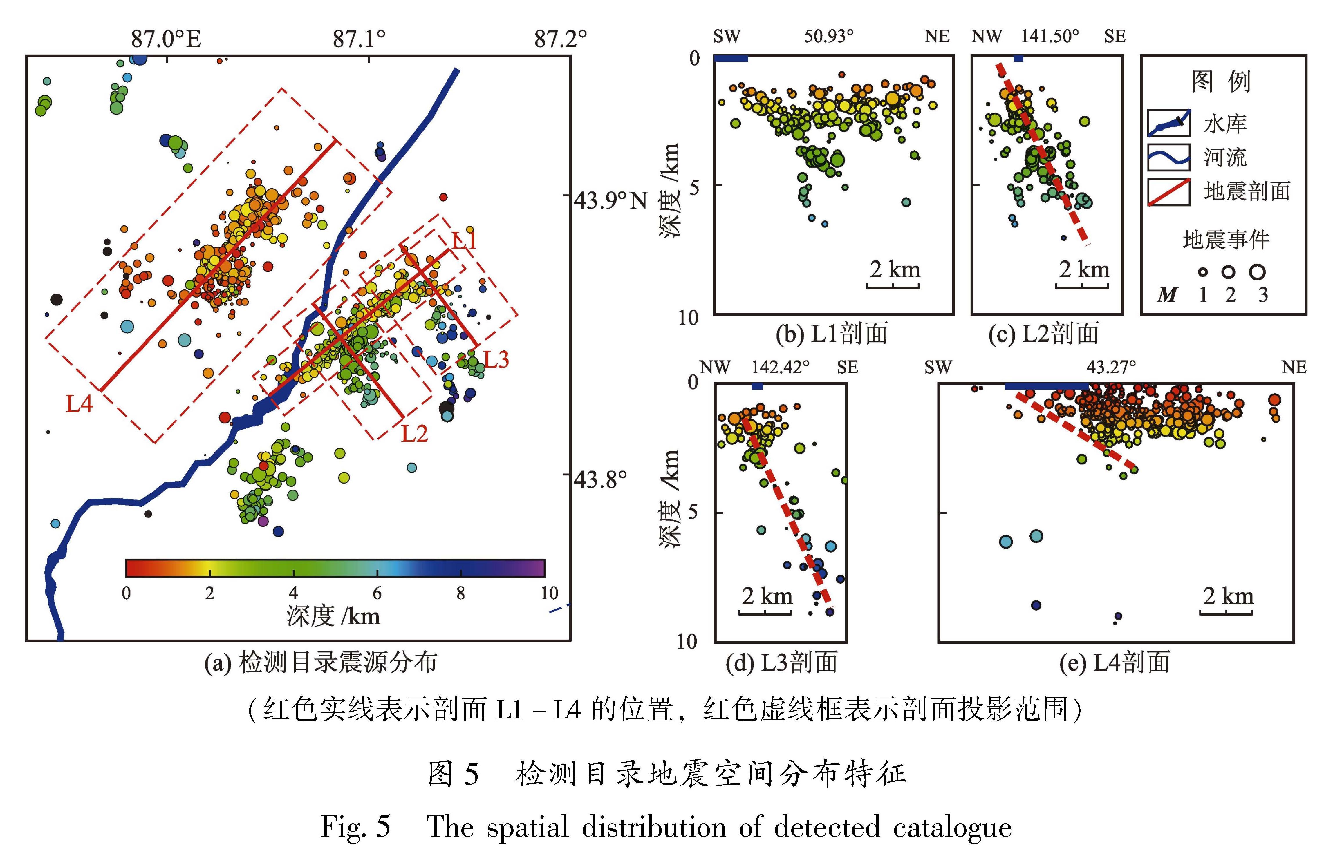
最终,2 649个检测事件中的1 064个事件被重新定位,占所有参与定位事件的40%,其中826个检测事件被定位于研究区域内(图5a)。走时残差从定位前的2.059 s减少到定位后的0.234 s。水平和垂直定位的平均偏差估计分别为0.184 km和0.205 km。
研究区域地震震源深度整体呈现西浅东深的分布特征(图5a)。以三屯河为界,河流西侧的地震活动主要分布在3 km以上的浅部地层中,由剖面L4可以看出此处的地震活动沿着倾向NNE、倾角约30°的北倾节面延伸至地下约3 km深处(图5e)。
河流东侧的地震活动则可以库区为界,划分为上游和下游两个丛集。位于库区上游的地震活动主要分布在约4 km深度(图5a); 位于库区下游的地震活动则表现出由西北向东南深度逐渐变深的特征。由剖面L2和L3可看出,位于库区下游的地震活动主要沿着倾向SE、倾角约60°的节面分布(图5c和图5d),延伸至地下9 km 深处。
根据震中空间分布特征,将努尔加水库周边地震活动划分为A、B和C三个丛集(图6)。结合地震活动的发震时刻,水库蓄水前地震活动主要分布在河流东岸库区上游约1 km的丛集C中(图6中黑色圆形)。蓄水后的地震活动主要集中在库区下游约5 km范围内(图6中红色圆形)河流东西两侧的丛集A和B中。蓄水后的地震深度优势分布在3 km以上(图6,红色柱状图)。相较于蓄水前的地震丛集(图6,黑柱状图),蓄水后
图6 蓄水前后研究区震中及深度分布特征
Fig.6 Distribution of the epicenters and focal depths in the study area before(black)and after(red) the Nurga Reservoir impoundment
的地震丛集具有更浅的震源深度优势分布。
水库蓄水后在库区下游出现的两个地震丛集(丛集A和丛集B)表现出截然不同的空间分布特征。两丛集分别沿着NEE和SE倾向的两个节面分布(图5),分属于不同的发震构造。发震构造和传播路径相似的地震在同一台站记录中具有相似的波形(Shelly et al,2007; Peng,Zhao,2009),表现为高互相关系数。分别在丛集A和B中选取了两个地震事件作为模板事件,并选择位于研究区域南边对两丛集地震活动具有相近传播路径的硫磺沟台(LHG)作为记录台站,分别统计两模板事件在研究区域地震记录中P波互相关系数(图7c,灰色时窗为互相关系数计算时窗,包含人工拾取的P波到达前0.5 s至到达后1.5 s)大于0.9的地震事件震中分布(图7a中蓝色圆和红色圆)。结果表明,与模板事件具有较高波形相似性(即具有较高P波互相关系数)的地震事件位于其所对应的丛集中,而位于不同丛集的地震事件P波波形相似性较低(图7c)。
为了进一步讨论A、B两丛集中地震事件的波形相似性,统计两丛集中任意1级以上事件对的P波互相关系数(图8),统计结果显示丛集内的事件对比丛集之间的事件对具有更高的互相关系数。P波波形互相关分析进一步表明,库区下游两丛集的地震活动具有不同的发震构造。
位于库区西北方向的丛集A位于昌吉背斜的北翼,沿着倾向NNE、倾角约30°的节面延伸至地下3 km。沿着昌吉背斜走向将地震定位结果投影至地震勘探测线Line 1(图9a)。剖面显示丛集A的地震活动主要集中在由南准噶尔断裂和反冲断层形成的楔形构造活动轴面区域。
楔形构造广泛分布于准噶尔盆地南缘和北天山山前冲断构造中,是其构造位移消减的主要方式之一(Qiu et al,2019)。楔形体端点限制的活动轴面之内发生褶皱变形,即反冲断层的下盘发生褶皱变形,其向前陆方向位移分量致使上盘地层抬升(李本亮等,2012)。反冲断层上盘被抬升的过程中在对应地层中积累了大量形变,形成局部应力集中,地震活动常常出现在这类地质构造中(Thomas et al,2017; Kandula et al,2022)。
图7 硫磺沟台(LHG)记录的部分事件波形互相关示意图
Fig.7 Cross-correlation of the waveforms of some seismic events recorded at Liuhuanggou station
与丛集A不同,位于库区东北方向的丛集B发生于喀拉扎背斜之上,其地震活动主要沿倾向东南、倾角约60°的节面分布。节面走向与喀拉扎断层相近,倾向相反。将地震定位结果沿喀拉扎背斜的走向投至地震勘探测线Line 2(图9b),尽管节面与已有的断层解译并不完全相符,但其产状与区域内存在的高倾角断层的构造特征相一致。
喀拉扎背斜内部存在多组台阶状逆断层楔形构造,地层多次重叠抬升(陈立春,2011; 李本亮等,2012),其主要受到由北向南反向冲断的喀拉扎断层控制(管树巍等,2006)。地震反射剖面显示喀拉扎断层为上陡下缓的向西北大角度倾斜的铲状断层,其在地下10 km产状趋于水平(李本亮等,2012)。背斜生长的过程中,在其北翼行成膝折带,膝折带枢纽和翼间脚恒定(陈杰等,2005),在浅部(≤10 km)发育有向东南倾斜的大倾角断层(李本亮等,2012)。
图8 丛集A和B任意1级以上地震事件对在硫磺沟台(LHG)地震记录中P波互相关系数
Fig.8 The P-wave cross-correlation coefficients of each seismic-event pair with the magnitude larger than 1 in Cluster A and Cluster B recorded at Liuhuanggou station
努尔加水库的库水水位主要受三屯河径流量变化的影响。三屯河是一条径流量年际变化平稳、但是年内径流季节性变化显著的内陆河(陈俊仁,2017; 张婉君,2020),这使得努尔加水库蓄水水位呈现出较为稳定的年变化特征,即水库的蓄水水位随着径流量开始增大逐渐上升,并在径流量逐渐减弱时达到峰值,其后逐渐下降直至新一轮汛期的开始。因此,河流径流量可以一定程度反映水库蓄水水位的年变化特征。收集三屯河1977—2019年间平均径流量作为径流量季节性变化的数据,将其与区域地震活动的月频次进行对比(图 10a)。
在努尔加水库蓄水之前,区域内地震活动通常不会超过一个月,且主要集中在库区上游的丛集C中(图 10b,灰色)。水库蓄水后,库区周边区域地震活动主要集中在下游的两个丛集中,并由深度较浅的丛集A开始(2015年),随后出现在深度较深的丛集B中(2016年)(图 10b)。两丛集内的地震活动序列持续时长显著增加,超过2个月。
2015年1月水库开始蓄水,9个月后随着蓄水后的首个汛期结束,地震在库区下游的丛集A 中开始活动。蓄水后的第二年(2016年), 丛集A的地震活动随着三屯河在3月汛期的开始而开始,并持续至9月汛期结束而结束(图 10a中,蓝色柱状图),图中三屯河径流量为碾盘庄水文站多年纪录平均结果。与之相类似,丛集B的地震活动开始于蓄水后第二年(2016年9月),并在之后的蓄水周期中丛集B的地震活动与三屯河汛期在时间上相一致。两个丛集表现出相似的年变化演化特征,即首次活动的年份中地震都开始于8月前后,并在9月达到峰值,而在次年,丛集内的地震活动自4月便开始活跃并在5—7月达到峰值(图 10)。这种年变化特征持续至2018年,库区周边地震活动随即逐渐减弱。
图 10 地震活动频次(a)、深度分布(b)和地震活动距离水库距离(c)的时间演化
Fig.10 The temporal evolution of the seismic rate(a),the depth distribution(b),and the distance between earthquake events and the Nurga Reservoir(c)in the study area
在汛期即将结束时,三屯河径流量逐渐减少,此时对应的水库蓄水水位接近当年的蓄水峰值。水库下游两丛集地震活动的首次活跃都出现这一时段(8—9月)。在丛集首次活动开始后的第二年,水库蓄水水位随着径流量的增加而上升,地震活动也随之逐渐增加并持续至径流量减少,直至汛期结束。地震活动频次随水库蓄水水位变化的特征在龙滩水库(华卫等,2012)、漫湾水库(李永莉等,2004)以及小湾水库(姜金钟等,2016)等水库触发地震的研究中得到证实。蓄水水位(库容)的变化与库区周边地震活动的相关性是判断水库触发地震的重要参数之一。努尔加水库蓄水后,地震活动频次与水库蓄水水位(库容)具有很好的相关性,表明库区的地震活动与水库蓄水紧密相关,库区周边存在水库触发地震的现象。
地震数目和震级通常遵循古登堡-里克特关系:logN=a-bM,其中b值被认为与地热梯度、区域应力状态等有关。水库触发地震序列的b值往往大于该区的背景b值,如中国新丰江水库(M6.1)(秦嘉政等,2009)、赞比亚-津巴布韦边界的卡里巴(Kariba)水库(M6.1)(Gough,Gough,1970; Gupta,2002)、希腊克里马斯塔(Kremasta)水库(M6.2)(Gupta et al,1972; Gupta,2002)和印度科伊纳(Koyna)水库(M6.3)(Gupta,1983,2002)。研究区域地震序列b值的大小是判断水库触发地震的重要标准之一。根据地震目录估计的b值为0.86,其增幅显然不及以主要由人类工业活动为主的诱发地震活动观测到的变化,但仍略高于北天山的背景b值统计结果(0.71)(苏乃秦等,2001)。
努尔加水库蓄水后,库区周边区域地震序列持续增长且与水库蓄水水位变化相关,蓄水后地震序列b值高于该区域背景值,表明努尔加水库库区周边的地震活动受到水库蓄水的影响,影响范围主要集中在库区下游5 km内沿河分布的两个地震丛集中。
努尔加水库地处北天山区域,最大主压应力近水平,库区附近以逆冲断层为主。由于缺少水位数据,难以对水位升降导致的库伦应力变化进行定量的估计,但是水库蓄水形成的地面载荷加载很难形成促进地下深处断运动的附加水平拉力(陈颙,2009),载荷更多起到稳定作用(Gough,Gough,1970; Beck,1976)。努尔加水库为中型水库,其蓄水量较小,蓄水引起的载荷变化也相对较弱。因此,载荷作用不应是努尔加水库蓄水对周边地震活动影响的主要因素。
努尔加水库下游的两个地震丛集发生于水库蓄水之后,其空间分布分别受到不同的地质构造控制。沿着地层倾角测算蓄水位置至两丛集的发震位置的距离。丛集的地震活动是由深度较浅的、距离更近的丛集A先开始,并在2016年之后逐渐由近至远、由浅至深地向丛集B迁移(图 10c)。坝址库盘区域出露的基岩地层为砂砾岩、砾岩,坝址属于弱透水—接近中等透水岩体,渗透率在几到几百×10-3μm2(郭召杰等,2007),并且在地层抬升过程中还会进一步发育裂隙和微裂隙,这些都会成为库水向下渗流的通道。库水沿着地层向地下渗流,流体的渗入会改变岩层中不连续面上的有效正应力(Gupta,1983,2002; 易立新等,2003),并对构造破碎带起到润滑作用,降低断层和岩体不间断面的强度和摩擦系数(Talwani,1997),促使构造应力释放,促使地震发生,地震活动通常表现出迁移特征(Gupta,2002; 周斌等,2010)。
值得注意的是,蓄水后两个地震丛集集中出现于抬升的断层和背斜生长形成的膝折带中,流体渗入引起本不活跃的背斜倾覆端的地震活动性增加。水库的建成是否会引起两个背斜下伏构造相连,使地区潜在发震震级大幅提升,仍需要进一步研究。在地质构造背景复杂,构造活动强烈的区域兴建水库需要进行更为详尽的地震地质调查及地震安全性评估。
本文采用微震检测及定位方法获得了较为完备且具有更高精度的努尔加水库库区周边地震目录,结合相关地质和水文地质资料,分析了库区周边地震活动和水库蓄水之间的关系,得出以下结论:
(1)努尔加水库蓄水后,区域地震活动的模式发生改变,地震活动频次及地震序列持续时间都显著增加,并与水库蓄水水位的变化相关。蓄水后的地震活动由浅至深,先后发生于库区下游的两丛集中,并分别受到昌吉背斜和喀拉扎背斜的控制,空间上表现出与区域构造相一致的特征,发震位置与坝址库盘区域出露的基岩地层具有一定程度的水文地质连通性,存在库水渗流的通道。
(2)水库蓄水后,库水沿着砂砾岩层向下渗流,改变了介质强度或断层的摩擦阻力,促使构造应力的释放,这是地震活动增加的主要物理机制。
(3)尽管观测到的较为显著的水库诱发地震活动出现在本不活跃的背斜倾覆端,但研究区域内没有出现更大范围的断层活化现象。水库诱发的地震主要集中在库区下游5 km范围内,并随着蓄水进入第三个周期后逐渐减弱。在之后的水库蓄水过程中是否还会诱发地震,是否会引起两个背斜下伏构造相连,进而导致库区潜在发震震级增大,仍需要更多的观测资料,并开展进一步研究。