1.1 数据采集
芦山7.0级地震是继汶川8.0级地震后,龙门山断裂带发生的又一次强烈的破坏性地震。此次地震共造成四川省21个区县受灾,等震线长轴呈NE向分布,灾区最高烈度为Ⅸ度,Ⅵ 度及以上烈度区总面积为18 682 km2。其中:Ⅸ 度区东北自芦山县太平镇、宝盛乡以北,西南至芦阳镇向阳村; Ⅷ 度区东北自芦山县宝盛乡漆树坪村,西南至天全县兴业乡,西北自宝兴县灵关镇,东南至名山城区; Ⅶ 度区东北自芦山县大川镇,西南至荥经县龙苍沟镇岗上村,西北自天全县紫石乡,东南至洪雅县汉王乡,Ⅵ 度区东北自大邑县新场镇李家山村,西南至甘洛县两河乡,西北自泸定县岚安乡,东南至丹棱县杨场镇(李志强等,2013)(图1)。
图1 2013年芦山7.0级地震烈度及调查点分布图
Fig.1 Distribution of survey points and seismic intensity of the Lushan MS7.0 earthquake in 2013
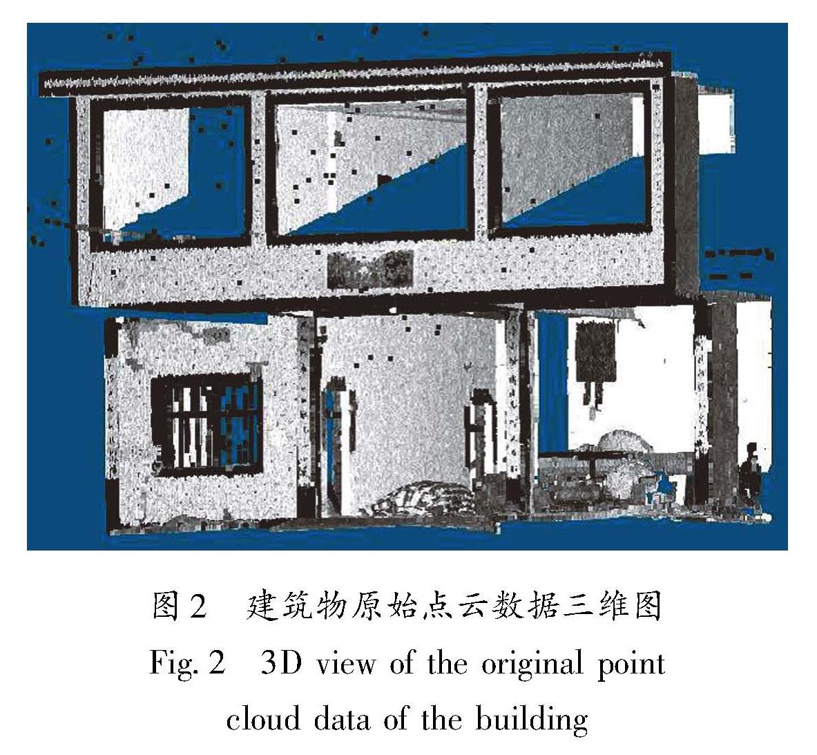
2013年8月,中国地震局地质研究所地震与地质灾害风险研究室工作人员进入芦山地震灾区,使用Trimble GX200三维激光扫描仪在Ⅵ、Ⅶ、Ⅷ、Ⅸ度区进行震后建筑物LiDAR数据采集,采样点要分布于芦山县、宝兴县、天全县、荥经县、雅安市、名山县等。采样点中基本完好建筑共采集91站(表1)。在数据采集过程中,为提高工作效率,每个建筑物采用夹角式扫描,即同时采集建筑物的正面和侧面; 为降低坐标误差,采用相对坐标的形式,即三维激光扫描仪所在点为控制点坐标。采集到的砌体建筑物原始三维点云数据如图2所示。
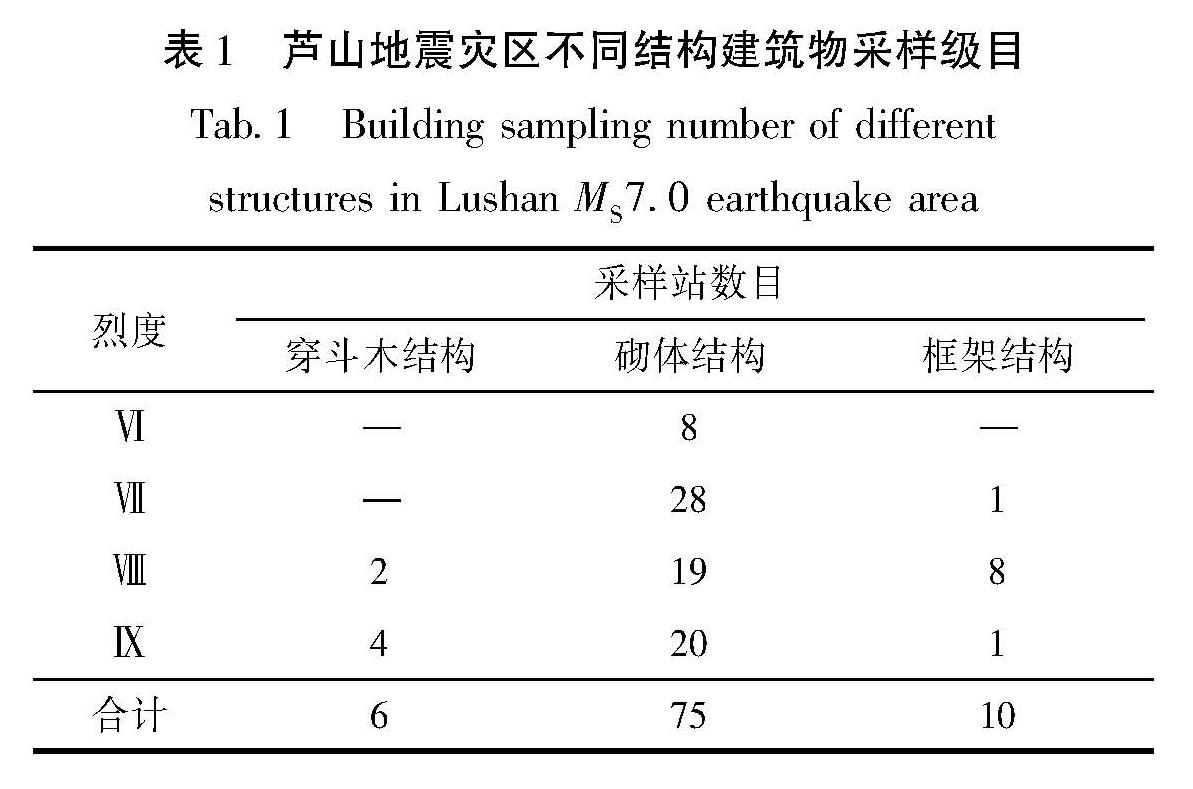
表1 芦山地震灾区不同结构建筑物采样级目
Tab.1 Building sampling number of different structures in Lushan MS7.0 earthquake area
烈度 采样站数目 穿斗木结构 砌体结构 框架结构Ⅵ — 8 —Ⅶ — 28 1Ⅷ 2 19 8Ⅸ 4 20 1合计 6 75 10
本文采集震后基本完好砌体结构建筑物共75个站点,提取到140个外独立墙面,主要包括:①砖木结构,其建筑特点是:砖墙砌体,没有采取抗震设防措施,屋顶为平屋顶或人字屋顶的木梁和瓦片; ②砖混结构(非设防),其建筑特点是:建筑成本低廉,不具备抗震设防构造,承重墙为砖砌体,没有钢筋水泥混凝土柱和梁,屋顶为预制板; ③砖混结构(设防),其建筑特点是:有抗震设防构造,在墙角有构造柱与墙面共同承重,构造柱的厚度与墙体厚度相同,一楼、二楼屋顶为钢筋水泥浇筑,同时配有承重梁和地圈梁,开间较大(张令心等,2019)。由于采集到的木结构
图2 建筑物原始点云数据三维图
Fig.2 3D view of the original point cloud data of the building
建筑和框架结构建筑LiDAR点云数据较少,因此未开展点云背景值研究。
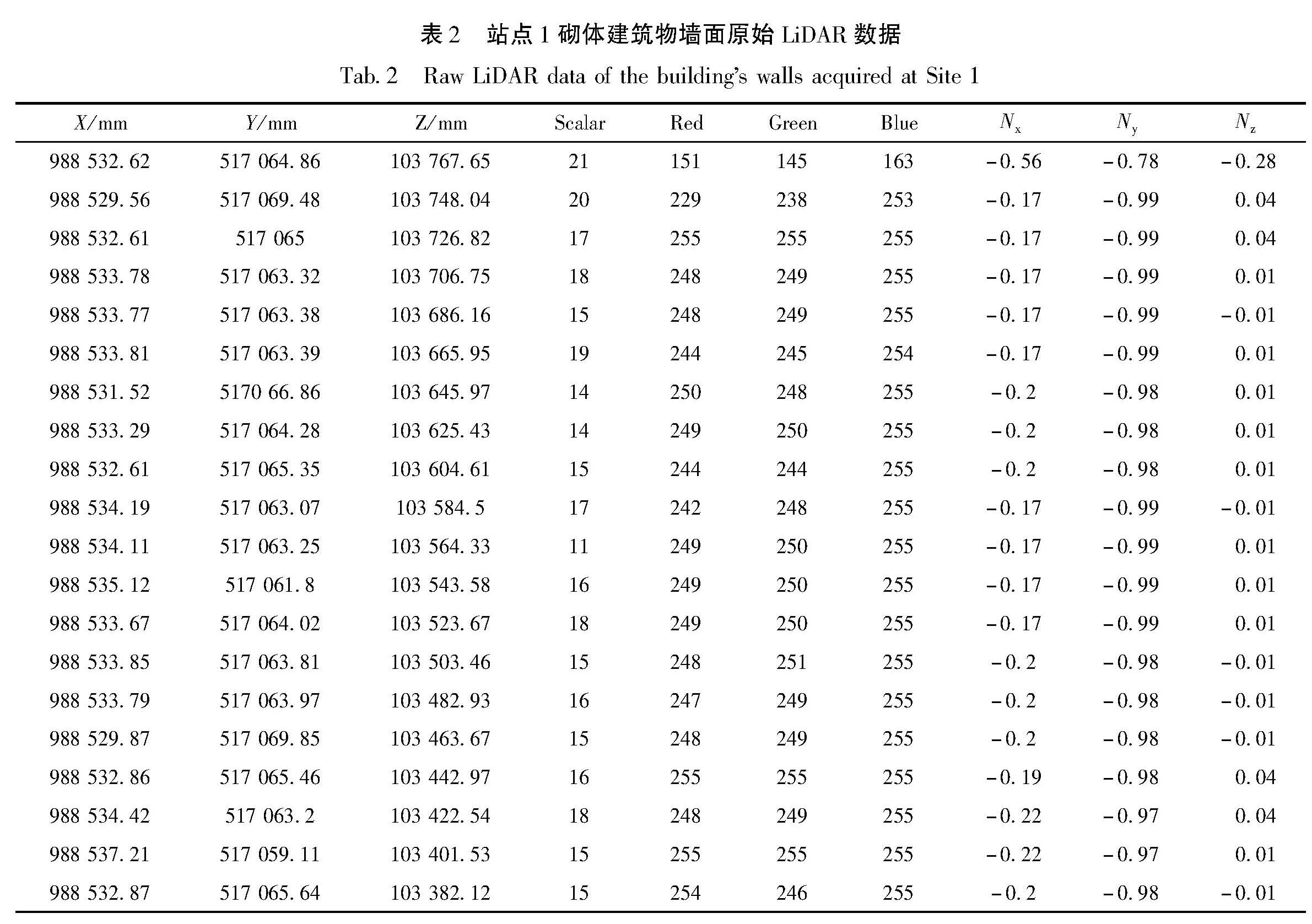
在站点1 采集到的砌体建筑物墙面的原始数据中,X、Y、Z为点云数据三维坐标空间位置信息,在数据采集过程中使用的是仪器相对坐标,单位为mm; Scalar为信号反射强度; Red、Green、Blue为点云数据颜色信息; Nx、Ny、Nz为点云数据法线信息(表2)。
表2 站点1砌体建筑物墙面原始LiDAR数据
Tab.2 Raw LiDAR data of the building's walls acquired at Site 1
从采集到的点云数据及可视化图像(图2)可以看出,三维激光扫描仪的点云数据具有以下特点:点云密度高、点云数据量大、包含目标物光学特征信息及反射强度信息、仪器原始扫描数据能够自动计算生成法线信息。
1.2 计算方法
采集过程中,受外界环境及仪器设备自身的干扰影响,如水汽、光折射、障碍物以及目标物本身,点云数据会产生异常值,会增加数据量的冗余。异常值类型包括漂移点、孤立点、冗余点、混杂点。为了提高点云数据后期分析的精准性,需要进行滤波去噪、分割、提取、坐标系转换处理,以达到分析需求的格式要求(杨凡,2022; 王斌等,2023)。
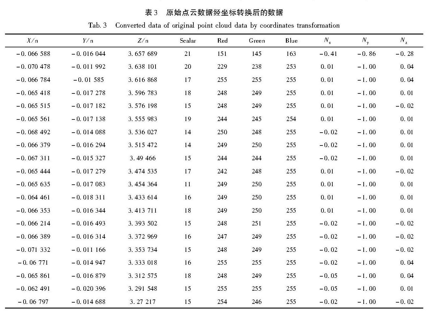
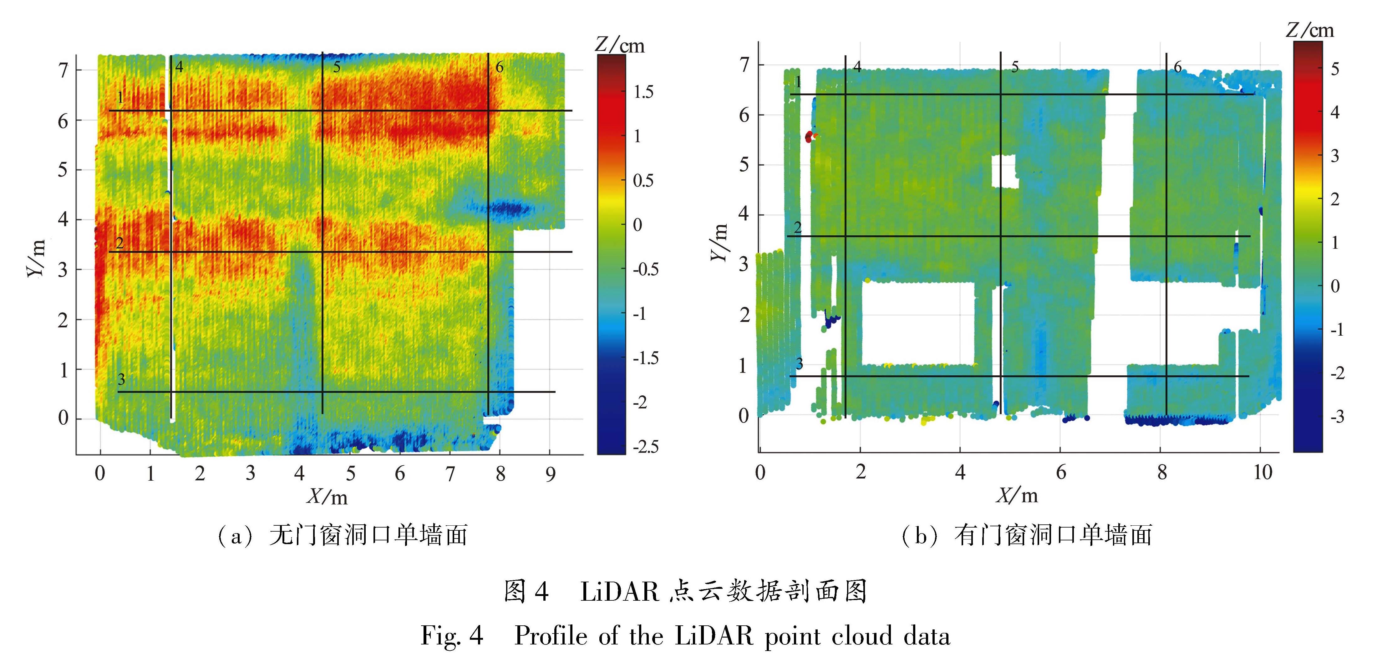
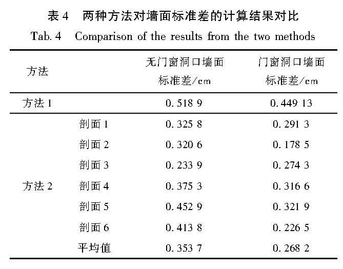
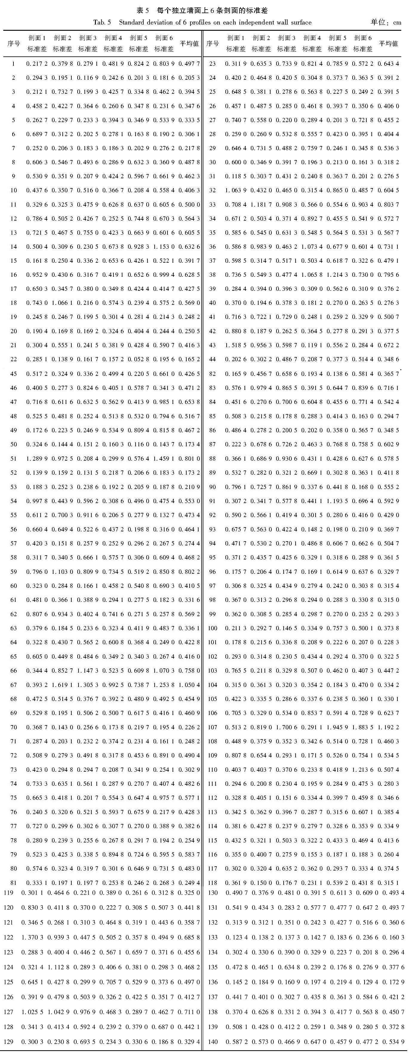
在数据处理过程中,最关键的是坐标转换。数据在采集过程中使用的是仪器相对坐标,在震害信息提取过程中会产生误差,不能够呈现出数据的真实性,同时掩盖了震害特征信息。本次数据采集通过仪器自带的realworks软件提供的基本功能进行点云去噪、滤波处理、坐标转换等,将原始数据提取为独立墙面,定义墙体点云数据的左下角为原点坐标X、Y、Z的起点(0,0,0),对处理后的数据按照单位为m的规范进行转存。对原始LiDAR点云数据进行坐标转换后的结果见表3,其中X为横坐标,Y为纵坐标,Z为变形值。
表3 原始点云数据经坐标转换后的数据
Tab.3 Converted data of original point cloud data by coordinates transformation
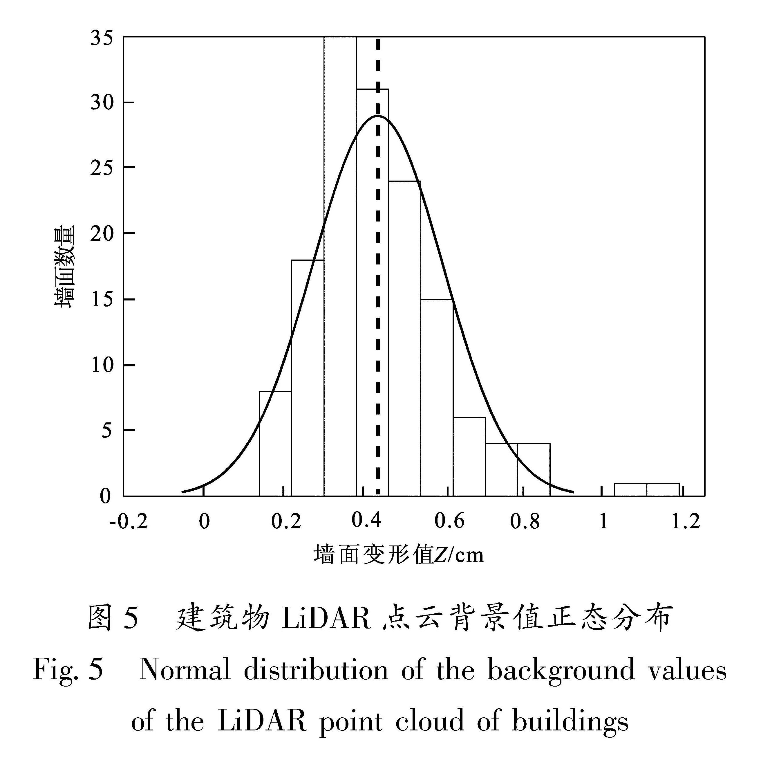
利用Matlab代码读取加载砌体建筑物墙面的LiDAR数据,获取墙面LiDAR点云数据的三维坐标值X、Y、Z。其中X为墙面的长度,Y为墙面的高度,Z为垂直于墙面的起伏变形量。若Z值为正,则该点为垂直于墙面向内凸出; 若Z值为负,则该点为垂直于墙面向外凸出(图3)。Z值的起伏变化,代表了墙面平整度,Z值趋于平面的起伏变化区间值的计算方法如下:
(1)提取墙面LiDAR点云数据坐标Z值,求得Z值的平均值δ为:
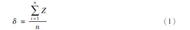
式中:Z为墙面变形值; δ为平均值; n为点云个数; Zi为第i个点的Z值。
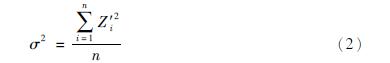
(2)计算墙面LiDAR点云每个点坐标Z值与平均值δ距离Zi'的平方σ2,然后求平均值:
(3)对步骤2的方差值求平方根,得到墙面LiDAR点云数据坐标Z值的标准差σ为:
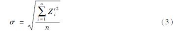
(4)根据上述计算求得的σ,得到墙面LiDAR点云坐标Z值趋于平面的起伏变化区间。
图3 砌体建筑墙面LiDAR点云变形量分布
Fig.3 Distribution of the LiDAR point cloud deformation on the wall