基金项目:山东“十五“网络工程项目(SD10501-01)资助.
(Earthquake Administration of Shandong province,Jinan 250014,Shandong,China)
digitial seismic network; monitoring capacity; Shandong Province
备注
基金项目:山东“十五“网络工程项目(SD10501-01)资助.
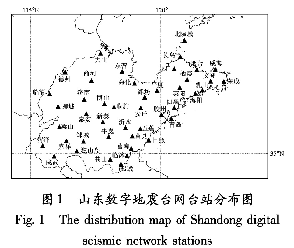
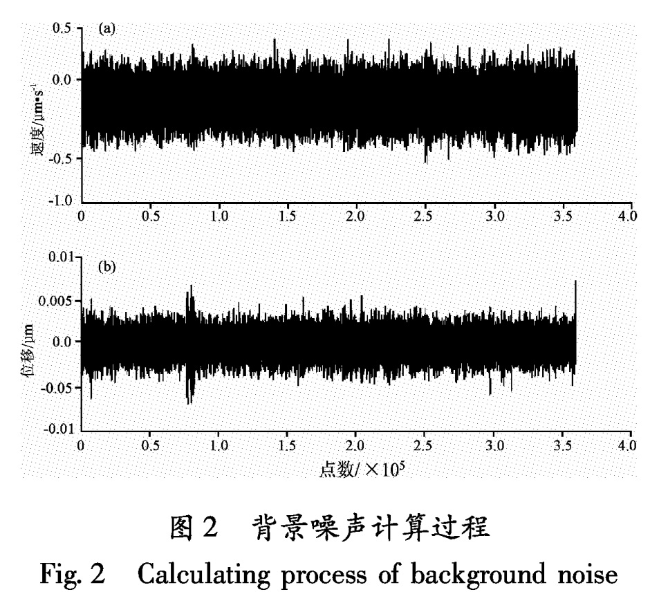
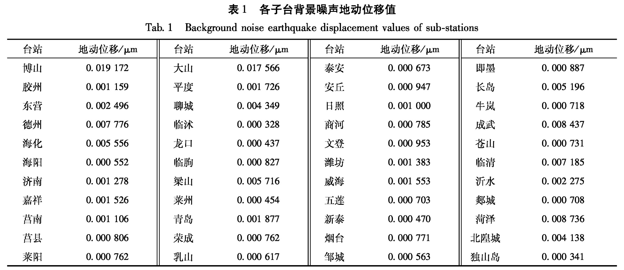
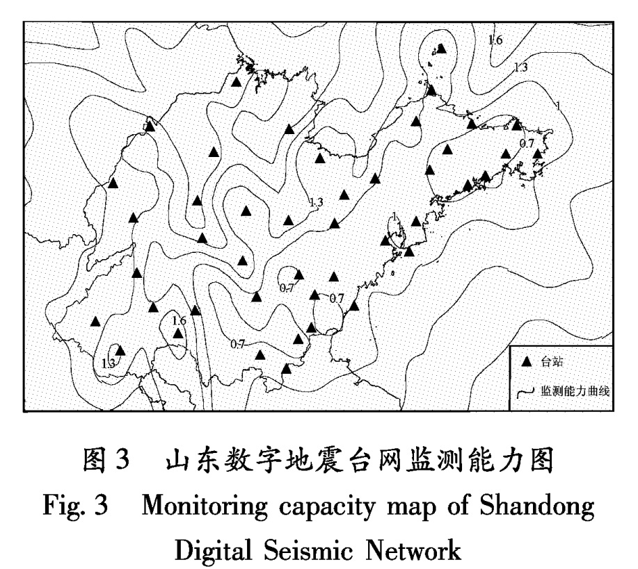
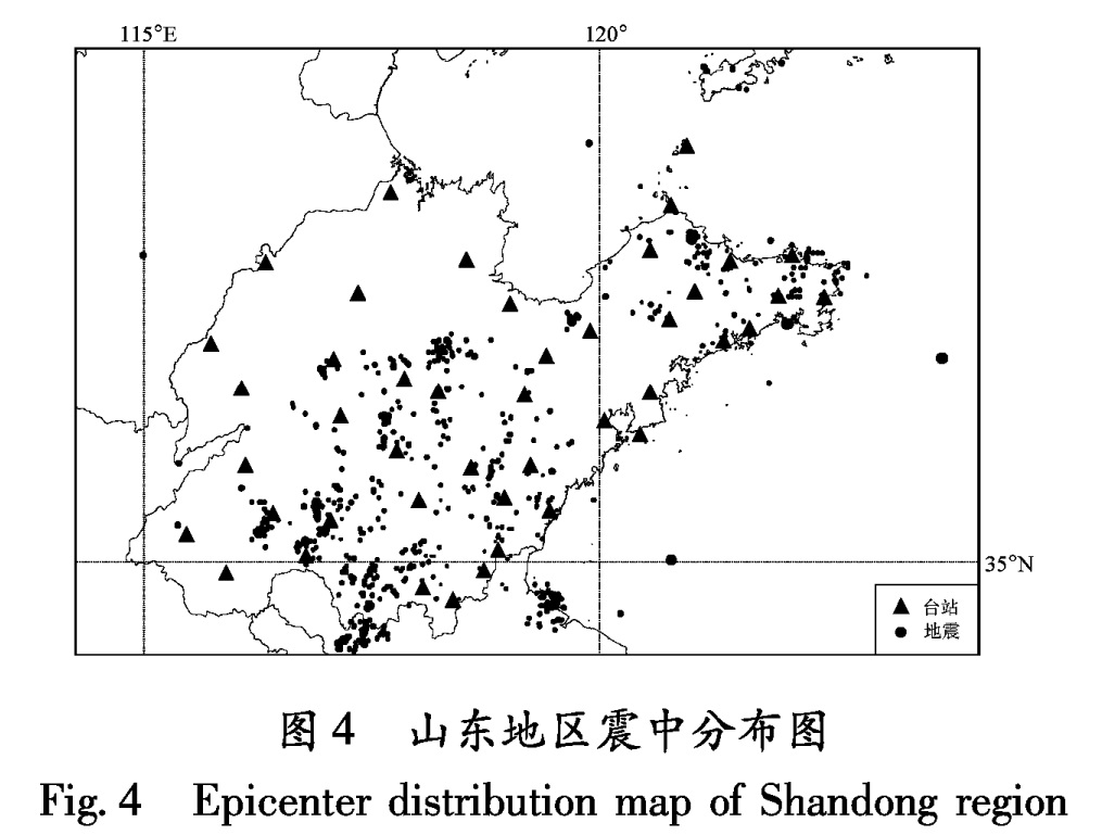
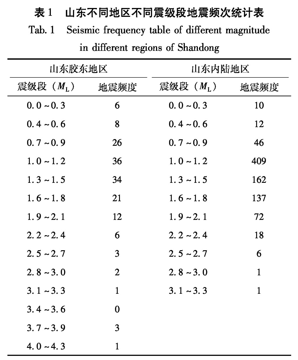
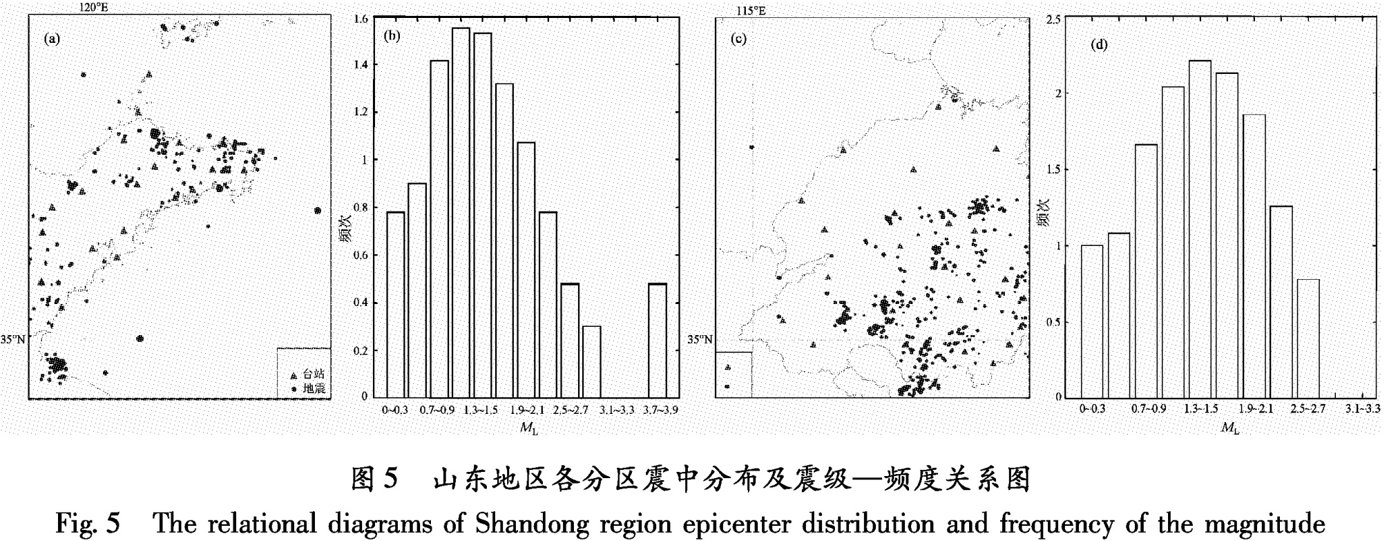
利用山东数字地震台网数字记录无震、无明显干扰事件情况下的44个台站背景噪声资料,计算了山东数字地震台网的监测能力,并利用“十五”台网试运行期间记录的爆破和地震事件进行检验,得出的计算结果与实际观测结果基本相符:鲁西地区、黄海和渤海海域的地震监测能力达到ML≥1.6,中东部地区地震监测能力达到ML≥1.3,胶东半岛部分地区和鲁南部分地区监测能力达到ML≥0.7。
The earthquake-monitoring capacity of Shandong digital seismic network is calculated by using the broad-band digital data of background noise record of 44 stations when there is no earthquake record or other disturbance,and also inspected by using the blast and seismic records of the tenth five-year plan network during test operation.The calculation results are in accordance with actual observation.In addition,the results show that the earthquake monitoring capacity has realized ML≥1.6 in Luxi area,Huanghai Sea and BohaiSea,ML≥1.3 in central and east area,ML≥0.7 in some region of Jiaodong Peninsula and some parts of the South.
引言
地震台网的监测能力是指台网能准确测定地震震中位置、发震时刻和震级等基本参数并满足一定精度要求下的台网控制面积,它是衡量台网质量的重要指标。台网监测能力与各个台站记录最小地震的能力有关,而这一能力又主要取决于技术系统的仪器响应灵敏度、仪器的观测动态范围和台址的地脉动噪声平均水平。
估算地震台网监测能力的方法有多种,如利用Bungum和Husebye的方法分析地方地震台网的检测能力和可靠性(Qaisar et al,2003),用平均可视分辨法估算地震台网的监测能力(王炎等,2001)等。一般的方法是根据近震震级公式,通过确定振幅比,用量规函数反推单台控制距离的方法,以4个及4个以上台站共同控制的区域来估算台网的监测范围。近期利用此方法所做的研究有:陕西数字地震台网的监测能力分析(孟智民等,2002); 赣南遥测数字地震台网监测能力估算(张黎珍等,2002); 甘肃省地震台网监测能力分析(何少林,2003); 河北省数字遥测地震台网的监测能力分析(李雪英等,2005); 福建数字地震台网对泉州地震的监测能力分析(洪星,杨贵,2005); 安徽省地震台网监测能力和监控范围估算(张有林等,2005); 西藏地震台网检测能力与定位能力评估(郝春月等,2005); 中国数字地震台网(CDSN)和IMS/PS台阵的监测定位能力评估(郝春月等,2006); 云南区域数字地震台网的监测能力与振幅问题(王俊等,2007); 阿坝州数字地震台网的动态范围与台网监控能力计算(李涌等,2007)。
目前,我国还没有统一的计算方法和程序用来计算地震台网的监测能力,要计算地震台网的监测能力,必须首先根据各台站的记录数据计算出台基的真实地噪声水平,再根据真实地噪声水平得到单台监测能力。本文中笔者将利用自己编写的软件,利用各台站地动噪声资料对山东省数字地震台网监测能力进行计算,并把计算结果与实际观测的震中分布作对比,以期为山东数字地震台网的“十一五”规划提供参考。
1 台网简介
山东省数字地震台网现有台站44个(图1),由“九五”台网7个台站和“十五”台网37个台站组成,大致均匀分布在山东省大部分地区。其中有1个超甚宽频带台站、11个甚宽频带台站、19个宽频带台站和13个短周期台站。传输方式为有线(DDN)传输、无线传输、光纤传输和CDMA传输。地震数据采集字长为24位,“九五”台网采样率为每秒50个采样点; “十五”台网采样率为每秒100个采样点,地震仪有效测量动态范围优于92 dB。系统具有宽频带、大动态、高分辨率等特点。按观测方式不同可将这44个台站划分为9个深井、5个半地下和洞体类型、30个地表台。
2 资料处理及结果
3 监测能力的检验
山东“十五”台网自2007年6月1日至8月31日试运行期间,3个以上台站记录清晰的爆破和地震事件共734个,图4、图5是采用这些资料绘出的震中分布图及震级频度图。
3.1 震中分布图检验由山东地区震中分布图(图4)可以看出,山东内陆大部分地区可监测到1.0级左右的地震或爆破事件,略高于图3给出的监测能力,这是由于计算绘制监测能力时使用4个台站定位,而在震中分布图中有些事件采用的是3个台站的数据定位结果。
3.2 震级频度图检验古登堡—里克特的震级—频度关系:lgN=a-bM,反映了在特定的区域内大小地震的比例关系,从微震到中强地震、大地震,其数量按对数关系衰减,b值因不同地区的平均应力状况及地质介质状况而异,因此,地震活动性不同的地区,b值便可能不同。如果将活动性差异极大的地区放在一起做lgN-M统计,就不可能真实地反映它们的地震活动状态,反映在lgN-M曲线形态上就可能是非线性的,或断续的。因此,根据山东地区地质构造及地震活动性特征和实际记录的事件数量,我们将山东地区划分为2个区域:山东胶东地区和中西部内陆地区,将台网监测得到的这一区域的地震目录作lgN-M统计。如果在某一震级范围内,lgN-M曲线是平直的,表明台网对这一地区这一震级范围的地震记录完整,反映客观实际,而在小震级的一端,曲线开始出现拐点,反映台网对小于这一震级的地震监控能力开始下降,记录出现遗漏。由此,我们可以确定台网对这一地区的地震监测能力。
从图5的震级—频度关系可以看出,山东胶东地区从震级ML0.7~0.9开始拐弯,确定台网对山东胶东地区监测能力达到ML0.9; 山东内陆地区从震级ML1.0~1.2开始拐弯,确定台网对山东中西部内陆地区监测能力达到ML1.2。鲁北和鲁西北地区在“十五”台网试运行期间未记到地震或爆破事件,所以无法进行检验。
表1 山东不同地区不同震级段地震频次统计表
Tab.1 Seismic frequency table of different magnitude in different regions of Shandong4 结论与讨论
(1)从图3、4、5可以看出,三者基本吻合,符合台网目前的实际情况。我省鲁西地区、黄海海域和渤海海域的地震监测能力实现了ML≥1.6,中东部地区地震监测能力实现了ML≥1.3,胶东半岛部分地区和鲁南部分地区监测能力达到ML≥0.7。
(2)通过“十五”台网的建设,山东数字地震台网的地震监测能力得到很大提高,特别是对胶东地区、沂沭带地区潜在震源区的微震监测能力大大提高,从“九五”台网(季爱东,石玉燕,2001)的2.0级提高到现在的1.3级。因为各台的观测环境、台基质量和背景噪声等条件的不同,所以它们对山东省地震监测所起的作用也不尽相同。鲁北、鲁西北地区台网布局比较稀疏、松散沉积较厚,背景噪声较大,导致监测能力相对偏低,对局部地区小地震的监测和定位精度都造成一定影响。应在该地区增加台站,以提高该区的监测能力。
(3)在分析计算过程中,没有考虑周边省份数据共享,因而有局限性。
本文得到刘希强研究员的指导帮助,在此深表谢意!
2.1 资料的选取以 “十五”山东数字地震台网在2007年6月~8月试运行期间的地震、爆破目录和报告为依据,根据《中国数字地震观测网络技术规程》(中国地震局,2005),随机地选择各台站30天所记录的宽频带噪声数据,每天抽取23:00:00至次日01:00:00连续两小时无震、无明显干扰情况下的背景噪声记录。
2.2 背景噪声地动位移的计算2.2.1 信号频域积分在频域里积分的基本原理是首先将需要积分的信号做傅立叶变换,然后将变换结果在频域里进行积分运算,经傅立叶逆变换得到积分后的时域信号。以下是具体运算方法:
根据傅立叶逆变换的公式,速度信号在任一频率的傅立叶分量可以表达为
v(t)=Vejωt.(1)
式中v(t)为速度信号在频率ω的傅立叶分量; V为对应v(t)的系数,j为虚数,即(-1)1/2。
对速度信号分量的时间积分可以得出信号的位移分量:
x(t)=∫t0v(τ)dτ=∫t0Vejωtdτ=V/(jω)ejωt=Xejωt.(2)
2.2.2 地动噪声的计算选取要研究的44个台站的地脉动连续小时记录数据。由于地震记录是Count值,所以首先要把小时记录转换成速度值,再用上述的频域积分公式把速度转换成位移。选取每个小时的水平向(NS和EW向)进行计算,则每小时地动位移的均方根值计算如下:
SMS=(1/2((∑x2NS)/N+(∑x2EW)/N))1/2.(3)
其中xNS是NS分向的地动位移值,xEW是EW分向的地动位移值,N是数据长度。
每个台的地动位移值为经过1~20 Hz的带通滤波,1小时地动位移的均方根值。背景噪声计算过程如图2所示,各子台背景噪声位移值如表1所示。
2.3 信噪比的确定确定信噪比即确定多大的地震信号才可能获得清楚的P波初动记录。根据观测规范中有关位移型观测的要求,当P波振幅是背景噪声振幅的2~3 倍时,P波震相可清晰辨认; 当S波振幅是P波振幅的2~3倍时,S波震相可清晰辨认。根据山东数字地震台网实际记录的地震波形资料的S波振幅和对各台站的地动噪声进行比较,认为S波最大振幅为平均地动噪声水平的4倍时,系统对地震事件的检测和对初至震相的识别毫无问题。故取S波最大振幅是背景噪声的4倍来计算山东数字地震台网的监测能力。
表1 各子台背景噪声地动位移值
Tab.1 Background noise earthquake displacement values of sub-stations2.4 单台监测范围的计算计算台网监测能力一般是根据近震震级公式:
ML=lgAμ+R(Δ)+S(Δ).(4)
式中ML表示用近震体波计算的震级,Aμ为以μm为单位的最大地动位移,R(Δ)为量规子函数,即震级的起算函数,S(Δ)为台站校正值。
虽然以上近震震级公式的量规函数是基于当时的基式地震仪和62、64型地震仪,而现在的山东数字地震台网各台站所用的大多是宽频带地震仪,但宽带数据经过短周期滤波后,数据相当于短周期地震仪记录的数据,理论上利用公式(4)进行估算是可行的。由于台站校正值一般也很小,故在误差许可范围内可认为S(Δ)为零,于是(4)式变为
ML=lgAμ+R(Δ).(5)
根据上一节的计算结果,在本文中取各地震台站的4倍背景噪声平均位移值为最小检测位移,即Aμ=4Aμ,代入(5)式计算出不同震级时的量规函数,再根据量规函数表查出相应震级下最大震中距,这样就得到了每个台站所能监测的相应震级下的最远震中距。
2.5 台网地震监测能力的确定根据地震定位原理,如果有4个或4个以上台站能同时记录到某一震级的地震,便认为台网对这一地区能监测该震级的地震。在程序的编制中我们以山东地区114°~124°E、34°~39°N的矩形区域作为计算范围,把此矩形区域划分成0.5°×0.5°的方块,逐块滑动计算台网对该区域中心所能监测到的最小地震,最小地震的震级即代表台网对该区域的监测能力,山东数字地震台网监测能力结果如图3所示。
- 傅淑芳,刘宝诚,李文艺.1980.地震学教程[M].北京:地震出版社.
- 国家地震局地球物理研究所.1978.近震分析[M].北京:地震出版社.
- 郝春月,索仁,才培拉姆,等.2005.西藏地震台网检测能力与定位能力评估[J].地震地磁观测与研究,26(6):73-76.
- 郝春月,郑重,郭燕平,等.2006.中国数字地震台网(CDSN)和IMS/PS台阵的监测定位能力评估[J].地震地磁观测与研究,27(2):56-63.
- 何少林.2003.甘肃省地震台网监测能力分析[J].地震地磁观测与研究,24(6):103-108.
- 洪星,杨贵.2005.福建数字地震台网对泉州地震的监测能力[J].地震地磁观测与研究,25(2):89-96.
- 季爱东,石玉燕.2001.山东数字遥测地震台网地震监测能力评估[J].高原地震,13(2):47-52.
- 李雪英,张新东,胡斌.2005.河北省数字遥测地震台网的监测能力[J].山西地震,(2):22-25.
- 李涌,张艺,戴仕贵.2007.阿坝州数字地震台网的动态范围与台网监控能力计算[J].四川地震,(4):37-41.
- 孟智民,王卫东,李大伟.2002.陕西数字地震台网的监测能力[J].西北地震学报,24(2):178-182.
- 王俊,蔡舒梅,崔庆谷.2007.云南区域数字地震台网的监测能力与振幅问题[J].地震地磁观测与研究,28(1):84-89.
- 王炎,赵淑珍,金文臣.2001.用平均可视分辨法估算山西大同数字遥测地震台网的遥测能力[J].山西地震,(4):8-10.
- 张黎珍,胡翠娥,李传江.2002.赣南遥测数字地震台网监测能力估算[J].华南地震,22(4):34-38.
- 张有林,戚浩,王燚坤,等.2005.安徽省地震台网监测能力和监控范围估算[J].地震地磁观测与研究,26(6):56-59.
- 中国地震局.2005.中国数字地震观测网络技术规程[M].北京:地震出版社.
- Qaisar M,Mahmood T,Khan S A.2003.巴基斯坦地方地震台网的检测能力和可靠性分析[J].地震学报,25(1):55-61.