基金项目:国家自然科学基金(40334040,40841017)和华北水利水电学院高层次人才科研启动项目联合资助.
(1.华北水利水电学院,郑州 450011; 2.中国地震局地球物理勘探中心,郑州 450002)
(1.North China University of Water Conservancy and Electric Power,Zhengzhou 450011,Henan,China)(2.Geophysical Exploration Center,CEA,Zhengzhou 450002,Henan,China)
basement,A'nyemaqen suture zone,structure,ray method,low velocity zone.
备注
基金项目:国家自然科学基金(40334040,40841017)和华北水利水电学院高层次人才科研启动项目联合资助.
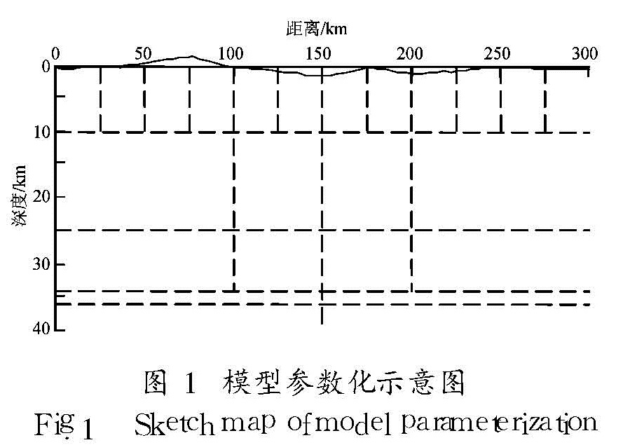
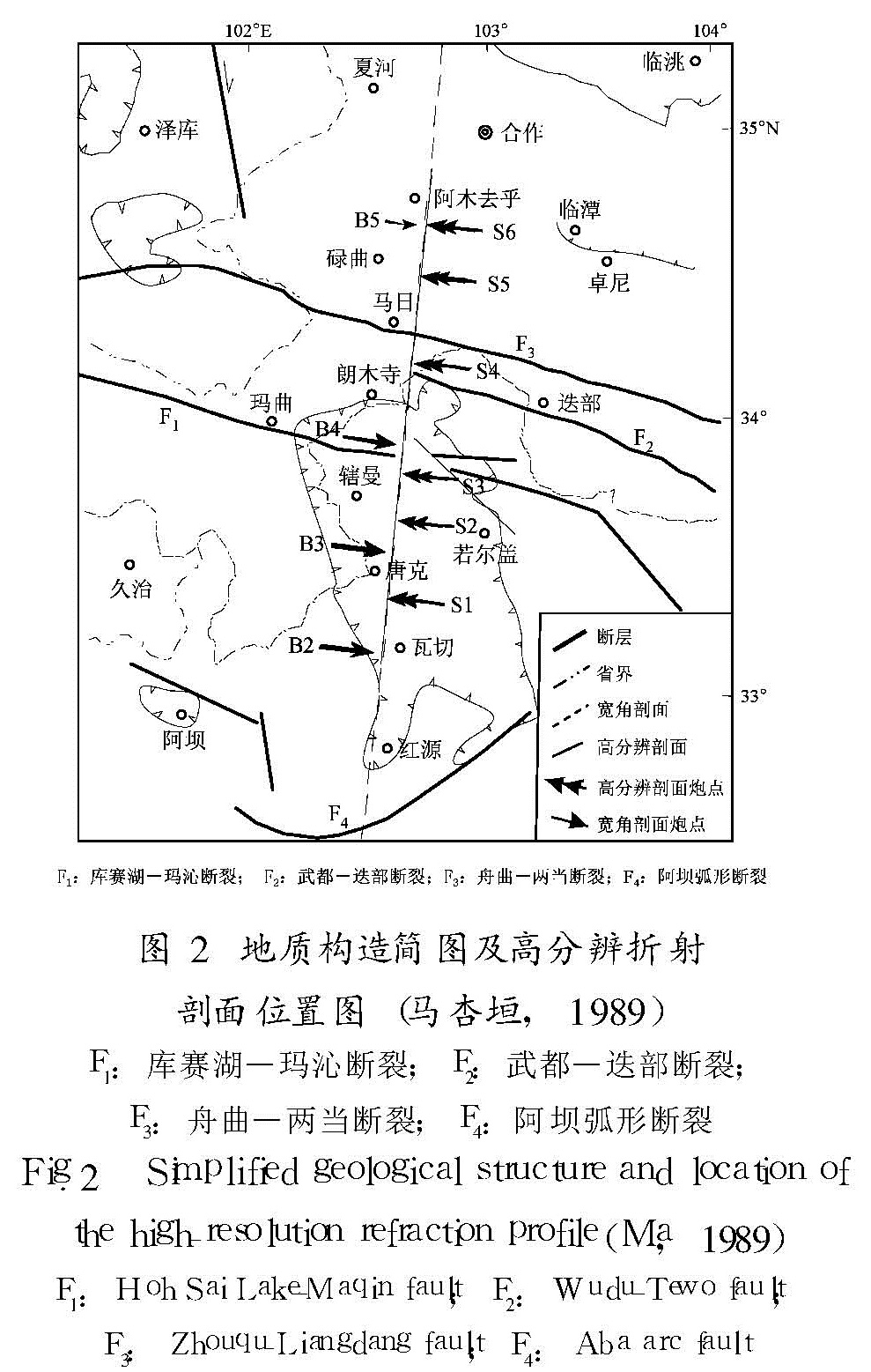
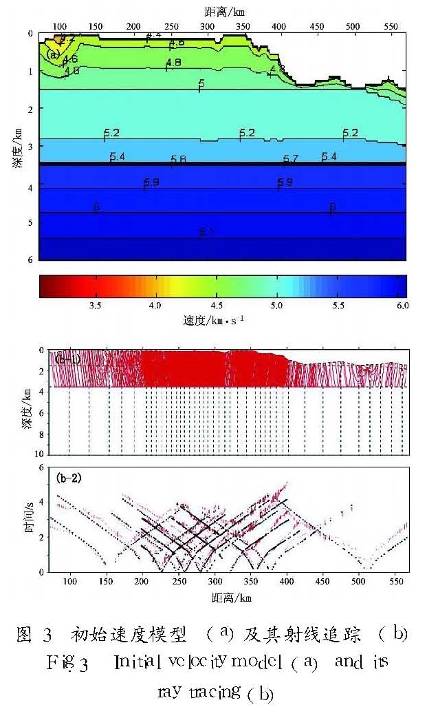
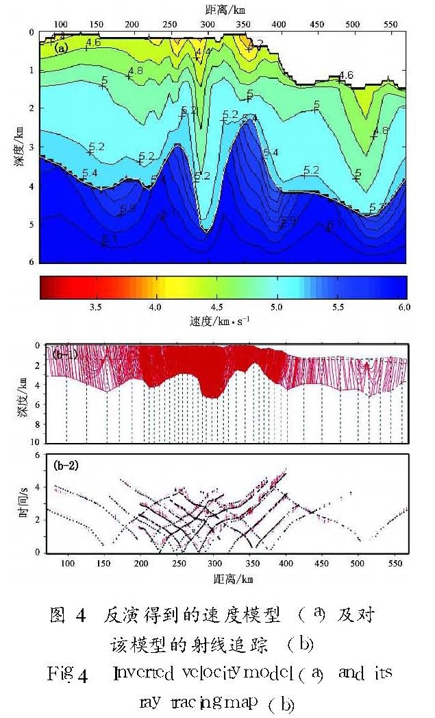
对11炮宽角地震反射/折射的Pg波走时数据进行了反演,结果表明:阿尼玛卿缝合带东段基底速度结构整体呈低速带分布,两侧的速度分布相对均匀; 缝合带内基底界面剧烈下凹,最深达5.5 km,不存在稳定的基底界面; 松潘—甘孜微块体基底界面整体埋深达3.5 km,相对平坦,其中部略微下凹; 从缝合带过渡到西秦岭褶皱带,基底界面急剧抬升至1.8 km,之后迅速下降至4.7 km,然后趋于平坦; 缝合带的地壳变形存在挤压和走滑两种形式,在缝合带及邻近地区,上部地壳物质曾有过向北方向逃逸的迹象。
The inversion results of the Pg data acquired by wide-angle seismic reflection/refraction data of 11 shots reveal that the basement velocity structure of the eastern part of A'nyemaqen suture zone is characterized by a low velocity zone while the velocity is even in its adjacent areas.The basement in A'nyemaqen suture zone is concave dramatically.Its maximum depth is about 5.5 km in it.The depth of the basement interface in Songpan-Ganzi block is about 3.5 km,and it is flat.The concave feature of the basement interface also appears in the middle part of Songpan-Ganzi block.In the transition zone between A'nyemaqen suture zone and West Qinling fold zone,the basement shallows rapidly up to a depth of 1.8 km,then deepens northwards up to 4.7 km,and finally becomes flat.There exist two kinds of crustal deformation,namely squeezing and striking in A'nyemaqen suture zone.The upper substance of crust has ever escaped northwards.
引言
青藏高原早已成为地学研究的热点地区,地球科学家将之视为研究陆陆碰撞、汇聚、俯冲、高原形成等大陆动力学基本问题的天然试验场。青藏高原东北缘是印度洋板块和欧亚板块碰撞作用由近南北方向向东和北东方向转换的重要场所,是物质东流的汇聚之处,其地壳变形最为强烈。在板块接触区域形成一系列规模宏大的褶皱系,如祁连褶皱系、东昆仑—西秦岭褶皱系、巴颜喀拉褶皱系和龙门山褶皱系等,也形成一些以逆冲、走滑为主的断裂带。阿尼玛卿缝合带东段是青藏高原东北缘重要的边界之一,处于松潘—甘孜地块、东昆仑断裂带和祁连褶皱带的结合部位,地质构造异常复杂。因此,对阿尼玛卿缝合带的研究有助于了解青藏高原的隆升机制、巨厚地壳的形成、物质东流等大陆动力学基本过程,对进一步了解板块碰撞的动力过程和西秦岭—东昆仑造山带的造山机制无疑有着十分重要的作用。20世纪80年代以来,我国地学工作者对青藏高原东北缘的构造演化、形变和造山过程等方面进行了大量的研究(杨经绥等,2005; 边千韬等,1999; 许志琴等,1991),近年来在该地区又开展了一些深部探测工作,获得了一些重要的结果,得到了青藏高原东北缘地壳的基本结构。有关专家学者还从不同的角度对地壳的变形特征进行了解释,给出了青藏高原东北缘不同区段复杂的深部构造图像和动力学模型(高锐等,2006; 王椿镛等,2003; 李松林等,2002; 张国伟等,2001; 燕明芝等,2006)。但是,在阿尼玛卿缝合带东段地壳构造变形强烈的地区,特别是自松潘—甘孜块体,经阿尼玛卿缝合带东段至祁连褶皱系东端,各主要构造单元的深部接触关系和地壳结构差异仍然有待探索。在国家重点自然基金的资助下,中国地震局地球物理勘探中心于2004年5月实施完成了一条主动源高分辨折射和宽角反射/折射地震测深的野外测线探测。本文使用高分辨折射以及与之重合的宽角反射/折射地震测深获得的Pg波资料,利用地震走时反演方法对阿尼玛卿缝合带东段及两侧的地壳基底结构进行了研究。
当前,科学家大体从地质学和地球物理学两个角度展开对基底的研究。地质学家主要根据区域地质、深钻井资料、P—T演化、矿物成分及年代测定等地质学方法来推断基底的空间分布特征(宋鸿彪,罗志立,1995; 刘援朝等,1997; 赵国春,孙敏,2002)。地震学家则利用地震层析成像及时间项图像等方法,对观测到的Pg波震相进行走时反演,从而间接得到基底的构造形态及速度分布。例如,王椿镛等(1997)利用有限差分成像的方法研究了大别造山带上部地壳结构; 宋占隆等(1997)利用层析成像反投影的方法和时间项方法,给出了华北地区结晶基底速度和时间项成像,并对这两种方法的数值模型数据的敏感性作了分析; 段永红等(2003)利用布设在长白山天池火山区的4条深地震测深剖面和1个三维地震透射台阵的Pg波资料,运用有限差分方法反演了天池火山区的基底速度结构; 赵俊猛(2004)等利用库尔勒—吉木萨尔地震宽角反射/折射剖面Pg震相,通过有限差分层析成像得到了天山造山带基底的速度分布及构造; 徐朝繁等(2006)根据伽师强震群区的高分辨折射地震资料,利用有限差分层析成像和射线数分布分析法,对该区上部地壳的精细结构进行了研究; 潘纪顺等(2008)利用多尺度逐次逼近退火遗传算法对阿尼玛卿缝合带东段及两侧的上部地壳速度结构进行了研究。尽管有限差分层析成像方法能够很好地描述基底的速度分布特征,但该方法却不能够直观地给出基底的界面形态。相反,时间项方法尽管可以给出基底的大体埋深及起伏状况,但对速度场的简化极为粗糙,而且不能得出基底的速度分布特征。笔者利用Zelt和Smith(1992)的射线反演方法,将Pg波看作是来自基底以上的回折波和来自基底界面的首波,进行速度和界面的联合走时反演,获得了有关基底的速度分布和界面形态。
1 基本原理
常用的宽角地震反射/折射走时数据的处理方法是试错拟合法(Cerveny et al,1977)。该方法不仅十分耗时,而且不能够提供模型参数的不确定性、分辨及唯一性等定量信息,更不能够保证数据拟合是某一特定范数下的极小。为克服以上不足,Zelt和Smith(1992)提出了一种可以同时获得速度和界面结构的地震走时反演方法,称为射线反演方法,该方法由模型参数化、射线追踪和阻尼最小二乘反演3部分组成,现阐述如下。
1.1 模型参数化速度模型可分成若干层,层内分为若干大小可变的四边形块体(图1)。图1中的模型分5层,包括13个边界节点和8个速度点,它们被21个独立参数定义。为进行射线追踪,模型自动分成24个四边形块体。层边界由连接边界节点的直线段构成。不同边界的边界节点的个数和位置可以不同,单个节点可表示水平边界,形态复杂的边界可用多个点描述。每一层内,P波波场由任意数目和间隔的层顶和层底速度点所指定。层顶速度点的个数和位置可以与层底及其它层速度点的个数和位置不同。每一层内,由4个速度点确定的每一个四边形块体的4条边上,速度呈线性变化。这种参数化方法有以下几个优点:① 四边形块体及其速度场表示具有普遍性,只需要最小数目的四边形就可以表示复杂的地壳模型; ② 模型分层的好处在于使射线追踪的参数相对简单和有效,模型和射线组的定义也更直接; ③ 所有边界节点和速度点之间的线性内插确保模型是可预测的且有好的“行为”; ④ 任何一个边界节点和速度点被调节时,模型仍保持一致和较好的定义; ⑤ 不规则四边形网格可灵活改变,从而可适应地下射线的覆盖和观测数据分辨的情况。
1.2 正演问题正演采用初值射线追踪算法。二维射线追踪方程可写成
(dz)/(dx)=ctgθ,(dθ)/(dx)=(vz-vxctgθ)/(v)(1)
或
(dx)/(dz)=tgθ,(dθ)/(dz)=(vztgθ-vx)/(v).(2)
式中,θ是射线和z轴的夹角,v是波速度,vx和vz 是波速度关于x和z坐标的偏导数。源位置坐标x0、z0和射线发射角θ0为已知的初始条件。求得一组其终点与观测点小于某一给定距离的射线,然后从中选出两条最近的射线内插得到要追踪的射线,初值射线追踪算法的效率远高于两点射线追踪,从而保证了方法的高效率。
1.3 反演问题反演采用阻尼最小二乘解法
Δm=(ATC-1tA+DC-1m)-1ATC-1tΔt.(3)
式中,Ct和Cm是估算数据和模型的协方差矩阵,D是总的阻尼参数。
Ct=diag{σ2i},
Cm=diag{σ2j}.(4)
式中,σi是走时测量误差,σj是第j个模型参数的先验误差估计。
1.4 目标函数定义走时残差的均方根为目标函数
Objective function=(1/m∑mi=1(tCi-tOi)2)1/2.(5)
式中,m为数据点总数,tCi和tOi.(5)
式中,计算和观测的走时数据。
1.5 反演迭代停止准则反演迭代停止准则和模型参数的个数及节点间隔的选择也是反演算法中,两个相互关联的重要方面。某次地震数据反演的最终模型是否可取,解释者须掌握两个准则:① 反演结果是否达到了预期的均方根走时残差和模型分辨。这两个值之间存在如下关系:增加模型参数可使走时残差减小,但同时总的参数分辨也将下降。② 全部观测点的所有射线尽可能地被追踪到。
2 数据采集及数据处理
为了研究阿尼玛卿缝合带东段及其两侧邻近区域的上部地壳结构特征,2004年5~6月,中国地震局地球物理勘探中心在实施马尔康—古浪约600 km长的宽角折射/反射人工地震测深剖面项目的同时,在川北与甘南交界地区完成了1条210 km,近南北走向,与宽角折射/反射人工地震测深剖面完全重合的高分辨折射地震探测剖面(图2)。其中测线190~263 km位于松潘—甘孜微块体内的若尔盖盆地,263~310 km位于阿尼玛卿缝合带上,310~400 km位于西秦岭褶皱构造区内。探测工作共11炮,获得高分辨折射剖面和宽角地震折射/反射剖面,得到1 105个Pg波观测走时,炮点在测线位置分别为154.344,205.707,226.181,247.189,258.495,280.078,290.418,321.104,356.268,377.104,511.636 km。
图2 地质构造简图及高分辨折射剖面位置图(马杏垣,1989)
F1:库赛湖—玛沁断裂; F2:武都—迭部断裂;
F3:舟曲—两当断裂; F4:阿坝弧形断裂
Fig.2 Simplified geological structure and location of the high-resolution refraction profile(Ma,1989) F1:Hoh Sai Lake-Maqin fault; F2:Wudu-Tewo fault;把初始模型中的基底界面设置为平界面,其埋深为3.5 km,初始速度模型为横向均匀。基底界面上、下初始速度分别设为5.3 km/s和5.8 km/s。地表各速度节点上的速度值均为4.5 km/s,为调节速度梯度的分布,在深度1.5 km处设一水平虚界面,该虚界面处的速度设为5.0 km/s(图3a)。利用射线反演方法对初始模型进行射线追踪(图3b),有效追踪的观测数据共1 098个,走时拟合的残差均方根为0.254 s,值为91.840。
从图4a可以看出,在若尔盖盆地和西秦岭褶皱带中南段区域,速度分布较为均匀,横向变化不大,与它们之间的低速断裂结构相比呈现相对稳定的速度结构特征。阿尼玛卿缝合带以整体低速背景下呈现非均匀性为特征,上地壳表现为低速条带结构。
阿尼玛卿缝合带内的基底界面整体呈剧烈下凹形态,基底变形最为强烈,因而稳定的基底界面不复存在,界面最深达5.5 km,位于测线298 km处。在缝合带南侧的松潘—甘孜微块体内,基底埋深为3.5 km,在其中部(测线170~250 km之间),基底界面下凹,深达4.0 km。在松潘—甘孜微块体与褶皱带的结合部,基底界面下凹,深达4.6 km。从阿尼玛卿缝合带过渡到西秦岭褶皱带,基底界面急剧抬升,从5.5 km抬升到1.8 km,对应测线363 km处。之后在西秦岭褶皱带内,基底界面急剧下降4.7 km,对应测线402 km处。之后,向大桩号方向,基底界面形态略微下凹,较平缓,基本维持在4.7 km的深度。阿尼玛卿缝合带的地壳变形体现了挤压与走滑的双重特征,其中挤压作用造成缝合带两侧基底的抬升,而且北侧的西秦岭抬升得更高。该区上部地壳物质曾有过向北或东北方向逃逸的迹象。
3 结论
(1)阿尼玛卿缝合带东段整体呈低速条带分布,存在严重的横向不均匀,而其两侧的若尔盖盆地和西秦岭褶皱带区域,速度分布较为均匀,横向变化不大。
(2)阿尼玛卿缝合带内基底界面剧烈下凹,稳定的基底界面不复存在,界面最深达5.5 km。
(3)若尔盖盆地基底相对其两侧山前区域呈上隆状态,起伏不大,其中部略有下凹,埋深约2.0~5.0 km,西秦岭褶皱带中南段区域基底起伏不大,埋深约1.0~3.0 km,从阿尼玛卿缝合带到西秦岭褶皱带,基底界面急剧变浅,继而又急剧变深,呈向北下陷的形态。
(4)阿尼玛卿缝合带的地壳变形体现了挤压与走滑的双重特征,其中挤压作用造成缝合带两侧基底的抬升,而且北侧的西秦岭抬升得更高。该区上部地壳物质曾有过向北或东北方向逃逸的迹象。
(5)若尔盖盆地受南北两侧的挤压影响而隆起,表明盆地中存在硬性地块,这说明松潘基底是一个古老的陆块。
- 边千韬,罗小全,陈海泓,等.1999.阿尼玛卿蛇绿岩带花岗—英云闪长岩锆石U-Pb同位素定年及大地构造意义[J].地质科学,34(4):420-426.
- 段永红,张先康,杨卓欣,等.2003.长白山天池火山区基底结构研究[J].地震地质,25(3):501-508.
- 高锐,马永生,李秋生,等.2006.松潘地块与西秦岭造山带下地壳的性质和关系——深地表反射部面的揭露[J].地质通报,25(12):1361-1367.
- 李松林,张先康,张成科,等.2002.玛沁—兰州—靖边地震测深剖面地壳速度结构初步研究[J].地球物理学报,45(2):210-217.
- 刘援朝,魏显贵,吴德超,等.1997.扬子地台北缘早前寒武纪结晶基底构造样式及变形特征[J].矿物岩石,17(增刊 I):88-96.
- 马杏垣.1989.中国岩石圈运力学图集[M].北京:中国地图出版社.
- 潘纪顺,唐杰,刘越,等.2008.多尺度逐次逼近退火遗传算法反演地壳速度结构[J].地震研究,31(3):255-261.
- 宋鸿彪,罗志立.1995.四川盆地基底及深部地质结构研究的进展[J].地学前缘,2(3):231-237.
- 宋占隆,杨卓欣,石金虎,等.1997.用Pg波走时重建华北地区结晶基底速度及时间项图像[J].华北地震科学,15(2):9-16.
- 王椿镛,韩渭宾,吴建平,等.2003.松潘—甘孜造山带地壳速度结构[J].地震学报,25(3):229-241.
- 王椿镛,张先康,丁志峰,等.1997.大别造山带上部地壳结构的有限差分成像[J].地球物理学报,40(4):495-501.
- 徐朝繁,张先康,张建狮,等.2006.射线数分布分析法及其在地壳上部复杂结构探测中的应用[J].地震学报,19(2):167-175.
- 许志琴,侯立玮,王大可,等.1991.“西康式”褶皱以及变形机制——一种新的造山带褶皱类型[J].中国区域地质,(1):1-9.
- 燕明芝,杨立明,白亚平,等,2006.青藏块体东北缘前兆场动态演化过程的探讨[J].地震研究,29(4):427-432.
- 杨经绥,许志琴,李海兵,等.2005.东昆仑阿尼玛卿地区古特提斯火山作用和板块构造体系[J].岩石矿物学杂志,24(5):369-380.
- 赵国春,孙敏.2002.华北克拉通基底构造单元特征及远古代拼合[J].中国科学(D辑),32(7):538-549.
- 张国伟,张本仁,袁学诚,等.2001.秦岭造山带与大陆动力学[M].北京:科学出版社.
- 赵俊猛,王清晨,段永红,等.2004.天山造山带基底结构的有限差分研究[J].中国科学(D辑),34(增刊 I):13-18.
- Cerveny V,Molotkov I A,Psencik I.1977.Ray Method in Seismology[M].Prague:University of Karlova.
- Zelt C A,Smith R B.1992.Seismic traveltime inversion for 2-D crustal velocity structure[J].Geophys J Int,108:16-34.