基金项目:“十一五”国家科技支撑课题(2006BAC01B03-01-01)和中国地震局“强化华北地区强震监视跟踪项目”联合资助.
(First Crust Monitoring and Application Center,CEA,Tianjin 300180,China)
Sichuan-Yunnan area,crustal horizontal activity,Indonesia earthquake,evolvement characteristics,mechanism analysis
备注
基金项目:“十一五”国家科技支撑课题(2006BAC01B03-01-01)和中国地震局“强化华北地区强震监视跟踪项目”联合资助.
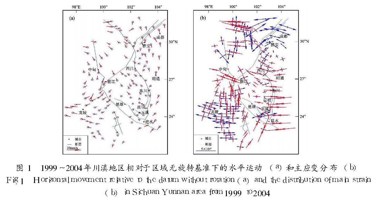
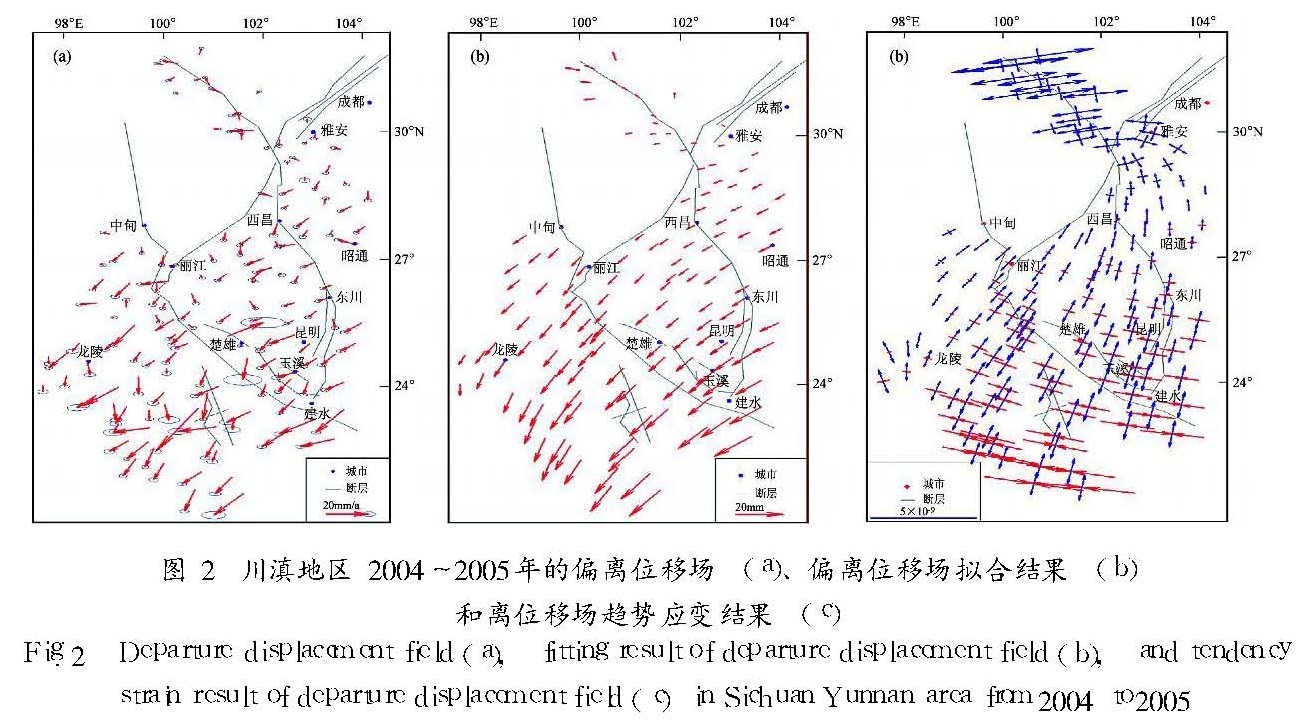
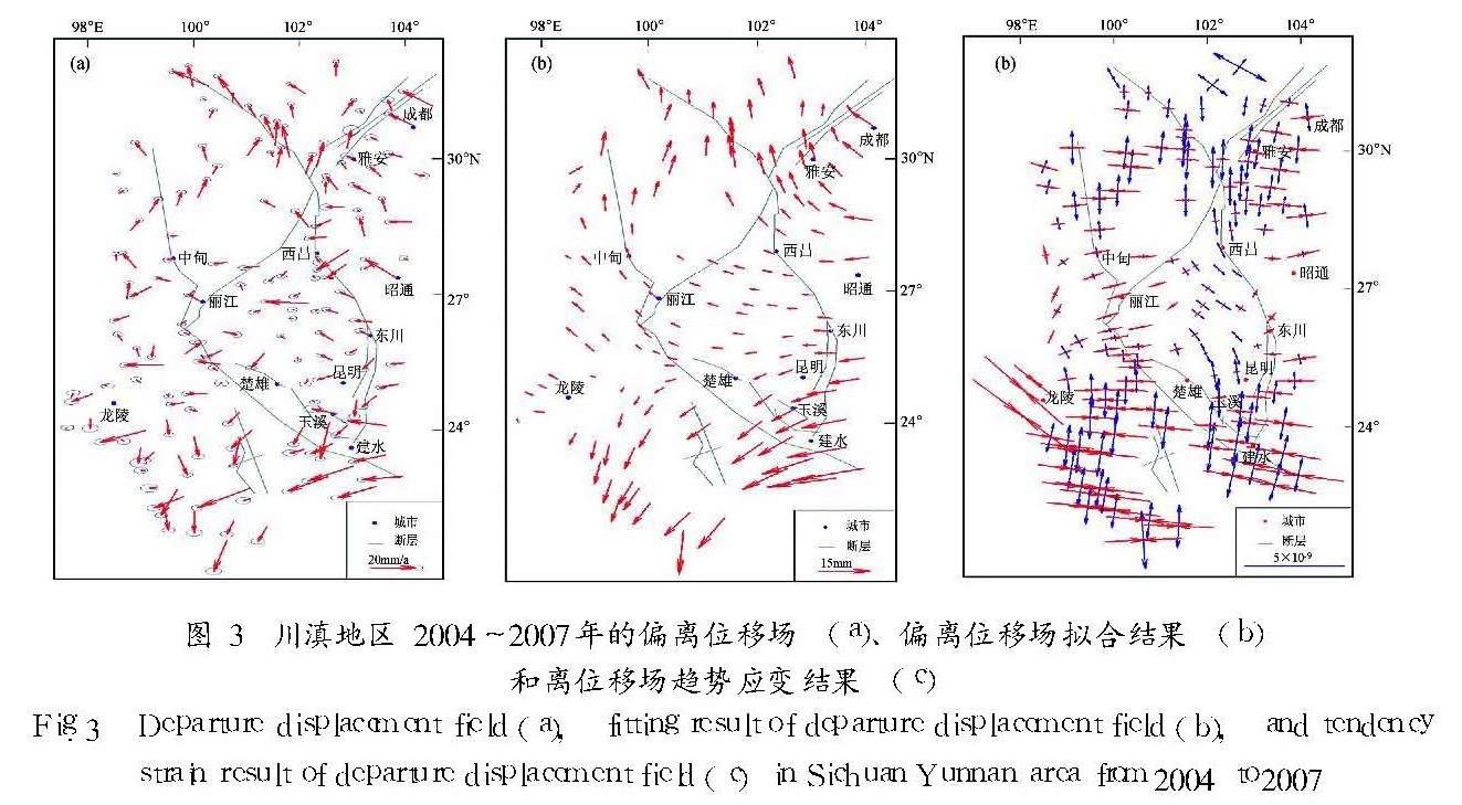
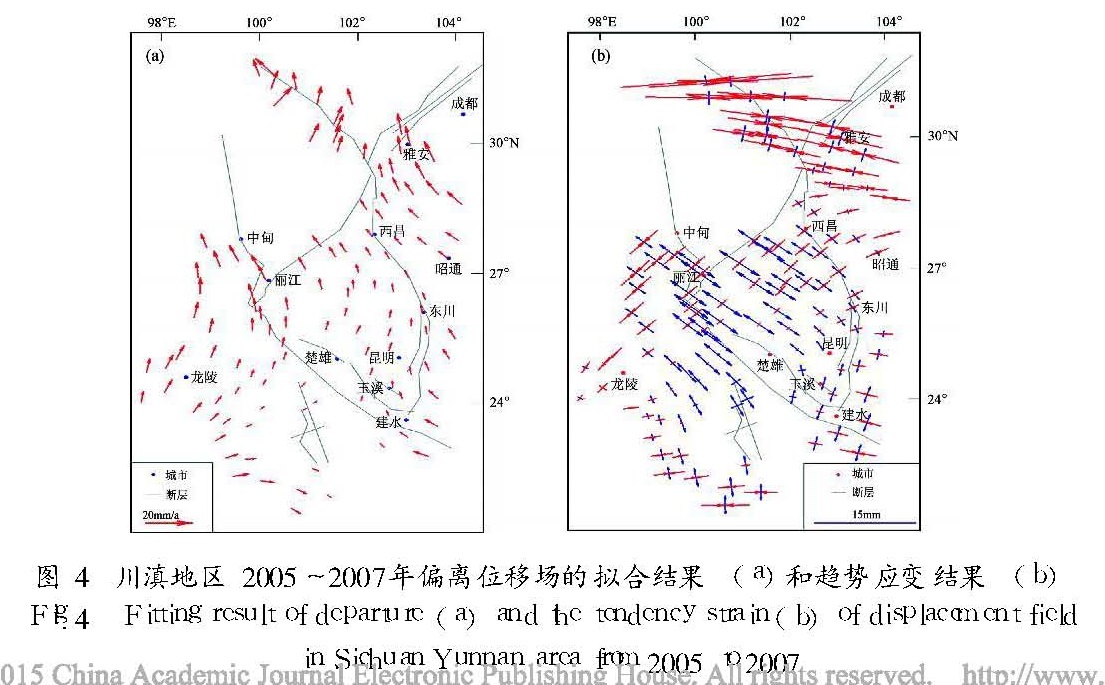
通过对川滇地区近年来的GPS资料的处理和分析,确定以1999~2004年的3期资料为基础获取相对于区域无旋转基准的背景性运动场,并以此为基本约束,利用2005年和2007年的资料分别获取不同时段的偏离位移场。综合运动场与位移场结果并借助连续应变模型分析了水平形变场的主要特征,得到如下结果:川滇菱形块体的东边界带是该区的主要形变带,菱形块体及以西的地域表现为明显的顺时针旋转形变运动。2004年12月26日印尼苏门答腊巨震的同震影响波及到川滇地区,导致该区中、南部产生SSW向偏离位移,北部产生NW向偏离位移,对汶川地震的发生可能有正影响作用。
Sichuan-Yunnan is the most prominent area in China for its ctrustal movement and deformation,so it becomes an indispensable aspect to realize its basic characteristic and dynamic change among a lot of research subjects in geology.Through processing and analyzing almost all the GPS data in this area in recent years,we obtain the background movement field relative to the data with no rotation based on 3 time period data from 1999 to 2004,and make it as the basic restriction to get respectively the departure displacement field of different period by using the data in 2005 and in 2007.Integrating the data in movement field and displacement field and using continuous strain model,we analyze the main characteristics of horizontal deformation field,and acquire results as follows:The main deformation region in Sichuan-Yunnan area is located in the east boundary of Sichuan-Yunnan Rhombic Block.The Block and the west region to it obviously revolved clockwise.The Indonesia earthquake on 26th December,2004 coseismicly affected Sichuan-Yunnan Area,and resulted in a departure displacement in SSW direction in the southern part and in NW direction in the northern part of Sichuan-Yunnan area.The Indonesia earthquake probably touched off the Wenchuan earthquake.
引言
川滇地区是我国地壳运动与变形最为突出的地区之一(王琪等,1998; 杨国华等,2003),区域内地震活动频繁,震级水平较高(皇甫岗等,2000; 苏有锦,秦嘉政,2001),其它一些地球物理与地球化学现象也比较突出,因而成为地学研究的一个热点地区,很多地震学者开展了多方面、多领域的研究工作(王晋南,王华林,1998; 沈军等,1997; 李齐等,2000; 谢富仁等,2001)。我国在地壳水平形变方面的研究有深厚的基础,跟踪研究也持续不断。在GPS技术未成熟或未广泛应用之前,我国几乎未开展大规模的地壳形变监测,加之施测精度难以提高等因素,研究区域的空间尺度相对较小,且彼此缺乏联系。20世纪90年代初,我国形变观测开始引入GPS技术,但监测规模仍然很小,点位的空间分布密度比较稀疏。真正具有规模性的水平形变监测始于“中国地壳运动观测网络”项目的实施,并于1999年开展了第一次大规模的监测。到目前为止该项目已经开展了多次监测,区域性的大规模监测共有5次,分别于1999、2001、2004、2005和2007年进行,研究成果也随之不断涌现。但随着研究的展开,诸多问题逐渐产生并干扰着某些方面研究的发展,如参考框架或参考基准的框动(抖动)、信息的提取与分离等,导致研究结论或多或少带有一些模糊性和差异性。此外,对“场”的时序性研究也偏少,这样不利于人们对整体的立体性把握。故此,本文从确立基本场(背景场)的角度出发,并在相同的参考基准下分离不同时段的偏离位移。这样我们就可能比较有把握地分析某一地震事件所产生的影响,分析不同时段的演变特征及机制,以及为不同的研究目标提供相应的或针对性的计算与分析结果。在此思路下,笔者对川滇地区近些年的地壳水平活动进行分析。
1 GPS数据处理方法
GPS前期数据处理软件为GAMIT/GLOBK/QOCA。处理过程大体分为3个步骤:(1)利用GAMIT软件获得测站坐标和卫星轨道的每日松弛解;(2)利用GLOBK软件将我们所获得的每日松弛解和国际全球导航卫星系统服务(IGS)数据中心SOPAC所产生的全球IGS跟踪站等的每日松弛解合并,得到一个既包含区域站又包含国际站的每日松弛解。该解包含了测站坐标、位移和卫星轨道参数的松弛解和相应的方差—协方差矩阵;(3)利用QOCA软件计算1999~2004年间研究区的基本水平运动速度并以该结果为背景值计算2005年和2007年两个时段的偏离位移场。本次计算时没有全部使用参与IFRT2000参考框架建设的测站,而使用中国周边地区运动的、线性性较好的、误差相对较小的测站。不论计算基本运动场还是偏离位移场,我们都选用1999~2007年时段的资料。需要指出的是,2001年昆仑山口西8.0级巨震对川滇地区可能存在影响,但有关研究表明它的同震影响并不明显,震后的影响也不大(杨国华等,2007),考虑到由于闭锁的作用,该地震孕育时在理论上会使川滇地区的运动稍有减弱,而地震发生后的解锁会使该区运动稍有加强,所以利用1999~2004年的资料是相对合适的。为了突出相对运动,笔者将1999~2004年研究区的运动结果归算到相对于区域无旋转基准的结果中(杨国华等,2005; 胡新康等,2007)。
在后期GPS数据处理中,由于地壳介质非各向同性,在提取低频应变信息时,只考虑线弹性是不够的,所以笔者使用非线性连续应变模型,由此所得结果一般仍属于低频结果,因为低频应变信息的提取还取决于研究区域的空间尺度和测站的分布情况。利用这个结果,我们可以把握场宏观特征,不至于被观测误差和局部的变化与扰动所干扰。因为该模型属于连续应变模型,所以若运动场不连续则分块计算。也就是说,这里除了给出观测偏离位移场以外,还给出利用模型所得到的偏离位移场的趋势性位移和趋势性主应变结果。GPS后期数据处理采用了以下模型:
[ve
vn]=r[-sinφcosλ -sinφsinλ cosφ
sinλ -cosλ 0][ωx
ωy
ωz]+
[εe 0.5εen
0.5εen εn][x
y].(1)
其中,
{x=rcosφ(λ-λ0)
y=r(φ-φ0),(2)
{εe=A0+A1x+A2y+A3x2+A4y2+A5x3+A6y3
εen=B0+B1x+B2y+B3x2+B4y2+B5x3+B6y3
εn=C0+C1x+C2y+C3x2+C4y2+C5x3+C6y3,(3)
{λ0=(∑λ)〖JB>1*/〗N
φ0=(∑φ)〖JB>1*/〗N,(4)
ve和vn分别是地壳上任一点(λ,φ)的东向速度与北向速度,r为地球平均半径,ωx、ωy、ωz为地壳运动的欧拉矢量,εe、εn、εen分别为地壳EW向线应变、SN向线应变、EW向与SN向之间的剪应变。笔者根据最小二乘原理求取上式中的有关参数,并计算和绘制有关结果和图件。
2 川滇地区水平运动基本场与动态演化特征
2.1 1999~2004年水平形变场图1a是相对于区域无旋转基准的水平运动结果,由图可以清楚地看到该区水平运动在空间上的差异变化。这种变化是很有序的,非连续形变区带主要体现在川滇菱形块体的东边界上,而其他活动断裂带两侧的差异活动与之相比表现很弱。这说明,该区近代地壳构造活动最活跃部位为川滇菱形块体的东边界,其它区带并不显著。若以川滇菱形块体的东边缘为界观察其东、西两侧的相对运动,则该界及附近地域的差异性运动均在10 mm/a以内,活动方式为左旋。随着EW向的空间延伸,这种差异运动也在扩大,最大可达15 mm/a。它反映了该边界的活动并不纯粹是走滑性的,还兼有剪切变形。此外,沿着边界带上这种差异活动并非完全相等,北部略大于南部。这是该带两侧相对运动的基本特征。川滇菱形块体东边缘以东的地块优势运动方向向北,地块内各站的运动数值一般在10 mm/a以内,其空间上的分布为“东大西小”。SN向的差异则不明显。差异变化的有序性与整体运动协调的一致性是该地块的主要特征。川滇菱形块体(该区的中间部分)的优势运动方向为SSE,运动量的分布为“北大南小”,北端超过5 mm/a,而南端则几乎为零。块体北半部为SN向伸展、EW向压缩的形变性质,南半部为SN向压缩、EW向伸展的形变性质。从图1a中的运动形态来看,它们的这种变化是渐变有序的。川滇菱形块体西边缘以西的地块有明显的顺时针旋转运动,运动量级约6 mm/a,但仔细观察不难发现它们不能很好地统一在欧拉运动模型下,这是因为该地块北半部的有序变化为“西小东大”,南半部则恰好相反。这表明该地块的运动中既含有刚性分量,也含有显著的变形分量,甚至到了南端其运动性质也在改变——近北向运动,大小约3 mm/a。上述事实从宏观上描述了川滇地区现代地壳水平运动的基本特征,该运动场也是我们今后要跟踪其动态变化的基本场或背景场。
图1 1999~2004年川滇地区相对于区域无旋转基准下的水平运动(a)和主应变分布(b)
Fig.1 Horizontal movement relative to the datum without rotation(a)and the distribution of main strain (b)in Sichuan-Yunnan area from 1999 to 2004为了便于分析川滇地区水平形变的机制,有必要利用运动场结果来获取与其相应的主应变率场。根据上述分析,我们进行了分块计算(图1b)。从运动场难以得到的结果,我们有可能在观察应变场时获得,所以要综合这两个场的结果进行分析才有可能把握水平运动与形变的本质。由图1b可知,川滇菱形块体以东的地块的应变在空间上有较大的差别。块体北部为EW向主压应变,量值在10-8/a以内,并由南向北逐渐变小。与其正交为SN方向的张应变,然而南端量值几乎为零,随着向北的延伸,量值虽然有所变大,但与主压应变相比仍小得多。这说明该段的剪切形变不显著。随着向北的延伸,该区段近EW向的主压应变逐渐变小,近SN向的张应变逐渐变大,并成为优势应变,但量值在5×10-9/a以内,它反映了该区段剪切形变相对突出的现象。再向北延伸,SN向的应变几乎为零,而EW向的主张应变则非常突出,在北端已接近10-8/a。这是该地块在空间上的趋势性变化特征。菱形块体的北半部以SN向拉张、EW向压缩的方式变形,其压缩变形在空间上的分布为“北大南小”,范围在(2~8)×10-9/a之间,SN向的拉张变形大致保持在(2~3)×10-9/a的范围内。在北半部块体的南端其形变的性质已经发生了改变,与菱形块体的南半部保持一致。菱形块体的南半部是川滇地区变形最小的地域,应变量级基本在2×10-9/a之内,但内部形变相对复杂,其变形的方式基本为北西—南东向至近南北向的压应变和近东西向的张应变。菱形块体以西的地块形变的整体一致性较好,其方式以南北向压缩、东西向拉张为优势形变特征,并且压性应变略小于张性应变,张性应变率在4×10-9/a之内,压性变率一般在3×10-9/a之内。这显示了该区由于受南北向的压缩而导致东西向的挤出变形特点。
2.2 2004~2005年偏离位移与应变场由上述结果可知,川滇地区地壳水平形变是相当强烈的,但由于地壳运动并非时时不变,故其演变规律是地壳形变的另一个主要研究内容。2004年12月26日印尼苏门答腊发生40年来全球最强烈的MS8.7巨震,其波及范围非常广。2005年初,中国地震局组织有关单位对川滇地区实施了GPS加密测量,目的在于获取该地震对于川滇地区地壳变形的影响。为了获取相关信息,我们在进行数据处理时以上述1999~2004年的运动速率结果为约束进行信息分离,得到偏离位移场(图2a)。图2b和图2c是根据GPS后期数据处理模型(公式1),利用图2a所示的位移计算得到的结果。由图可知,尽管2005年测量工作距上期(2004年)测量工作相距仅半年左右,但偏离位移信息仍然非常明显。由图2不难得到如下结论:① 在两次测量时间段,川滇地区内部及其附近地区无其他明显的地质事件发生,所以可以肯定图中所示的偏离位移主要为印尼巨震所导致; ② 印尼巨震的同震位移强度在空间上为“北弱南强”,而且基本上是渐变的、有序的; ③ 位移的方向及其变化也是有序的,测区北部为北西向,随着向南的深入,方向逐渐变为西向、西南向,优势位移的方向为西南向; ④ 位移的量级,北部为几毫米不等,中部由北向南逐渐变大,除少数点略超过10 mm外,大部分点在10 mm以内,南部大部分点的位移在15 mm之内,个别点达到了20 mm; ⑤ 看不出断层或边界带有明显的差异活动。这反映了该位移场具有整体性和渐变性的特征。图2c显示了由偏离位移场所表征的空间趋势性应变结果。由图可以看出,该时段的地壳变形整体上以近SN向的主拉张、近EW向的主压应变为主要特征,但应变的大小并非处处一致,在空间上的分布还是有一定的差别,主要表现为近SN向的拉张性应变由北向南逐渐增大,数值的变化范围大致为1×10⁻⁹~2×10⁻⁹。近EW向主压应变的变化顺序为南北两端大、中间小的格局; 由北向南的应变数值变化为5×10⁻⁹~-4×10⁻⁹,呈“北张南压”的势态。
2.3 2004~2007年偏离位移与应变场利用同样的方法,我们获得了川滇地区2004~2007年的累积偏离位移场、趋势性位移场和应变场(图3)。从图3可见,该时段发生了较大的变化。除了清晰可辨的印尼同震影响外,在一些空间上还叠加了新的偏离位移。尽管从图3a中看到有一些零乱的成分(图2a和图4a中也是这样),但有规律的变化仍然是清晰的。这种“零乱”的产生受多种因素的制约,如白噪声、非随机噪声、测站的地表扰动以及高频应变成分等等。本文同样只对变化的趋势进行分析,不对测站进行逐一描述。如图3b所示,位移形态着重以整体变形的方式进行,而刚性位移性则不明显。从位移形态观察,它受控于来自川滇地区以东的东部地壳物质的推挤与涌入,又似乎遇到了川滇以西地区的阻挡,使得物质移动的方向发生了变化,出现了图中所示的由中间偏南部位开始分化的北部向北移动、南部向南移动的格局。向北的位移的大小一般在10 mm以内,而向南的位移则大于北端,最大已经超过了15 mm。这表明该区域在南北方向上位移最大为25 mm。然而,最初由东向西的位移随着由东向西的空间延伸也在发生着变化,北部则迅速变为零,南部至该区的西缘也基本上变为零,中间部分的变化则不大。结合图3c我们能更好地把握其形变的宏观特征与局部的差异:主压应变方向为东西向,主张应变方向为南北向; 应变的大小存在着分区特征,南部地区最大,一般为3×10⁻⁹; 其次是北部地区,一般为2×10⁻⁹; 最小的是中部地区,一般在1×10⁻⁹范围内。以上描述基本上概括了2004~2007年偏离位移与形变的趋势性特征。观察这种累积偏离位移,它似乎与川滇地区内的断裂构造活动没有明显的关系,因为其变化在空间上与断裂活动性质不存在必然的联系。
2.4 2005~2007年偏离位移场与应变场由于上节所示的结果是2004~2007年的累积偏离位移与形变场,其中包含着2004年12月26日印尼8.7级巨震的同震影响成分,所以我们不太容易准确地了解2005~2007年时段的偏离位移。为获得该时段的偏离位移,我们只要剔除2004~2005年的同震位移量即可(图4)。由图
4a可知,该结果所反映的趋势特征非常清晰,优势位移方向向北,且由南向北逐渐变大,变化范围在-1~10 mm之间; EW位移分量较小,一般在-2~2 mm的范围内摆动。该时段的应变形态如图4b所示,北部应变较大,以压性为主,主压方向为近EW向,北端的最大压应变超过5×10⁻⁹,但接近中部时则变为1×10⁻⁹; SN向的张
图4 川滇地区2005~2007年偏离位移场的拟合结果(a)和趋势应变结果(b)
Fig.4 Fitting result of departure(a)and the tendency strain(b)of displacement field in Sichuan-Yunnan area from 2005 to 2007应变相对小得多,且在空间上的变化也不大,一般在1×10⁻⁹之内。进入到中部地区,其形变的性质发生了改变,张性变化相对突出,方向为北西—南东,数值范围为1×10⁻⁹~3×10⁻⁹,最大应变位于中部的中心地带,与之正交的压应变在2×10⁻⁹之内,空间上呈“西大东小”的势态。到川滇地区的南部,主应变的方向又变到“南北压、东西张”的趋势,张应变和压应变的量级大致等同,约在2×10⁻⁹范围内。这就是该时段偏离位移与应变的基本轮廓。
3 水平运动与变形机制的讨论
所谓“南北地震带”,从地壳形变的角度看,它实际上是一个东西向运动的消减带。也就是说来自于青藏块体向东的运动,遇到了华南和华北块体的阻挡,使物质流向发生了很大的改变,所以造成了该带南北向相对运动的基本格局。而对于川滇地区就有所谓“逃逸”的说法(Tapponnier,Molnar,1977)。实际上,区内的运动格局同时受活动构造的控制,明显起作用的是川滇菱形块体东界的断裂带(东界以东属华南块体)。此外,由于云南南端地块的有力阻挡,又进一步使物质的流向发生了改变。事实上,就变形区而言运动方向总是指向物质较“软”、易变形的区域,而川滇西南区域就是这样的地区,所以运动方向不得不向西。川滇西南区域的龙陵以西地区运动量值最大,这可能是由于物质移动的“通道”变窄的缘故,所以物质“流动”速度被迫加快。基于这些因素,就形成了图1a所示的运动与应变的基本轮廓。这说明川滇地区地震活动水平高是有着深刻的形变背景的,也预示着主应变在空间上的大小和方向与地壳介质的物性和外界作用的性质有关。
2004~2005年的偏离位移与形变主要体现了印尼巨震的同震影响。该地震对川滇地区地壳水平活动的影响不但显著,而且有序,但与该区地壳趋势性(基本场)水平活动并不相同。从位移场的角度来看,川滇地区所出现的南南西位移可能是由于同震破裂导致川滇以南地区向南南西的一个让位空间,以及由东向西的推挤和来自于青藏高原的背景性物质涌入等因素共同所致。从形变的性质来看,该区北部所出现的近东西向张应变也是由于物质迅速向南南西的移动,某种程度上缓解了由于背景场所导致的东向挤压作用,而此时由东向西的物质推挤与涌入在南段虽然显著,但尚未明显地波及到北端,但由于距震中较远,其应力场的调整与传递需要一个过程,而后来印尼又发生一系列强震的事实也表明应力场调整尚未结束。所以,该时段的结果可能不一定是该次地震对川滇地区的全部影响。从背景场的角度来观察,该次地震对川滇地区的地壳形变在宏观上有一种缓解作用。由于这种作用,从某种程度上说本区带可能发生的强震在时间上也会有所推迟,但形变状态的突然改变毕竟会使原有的平衡暂时被打破,所以很可能对该区中、小地震活动在较短的时间内起促进作用,但不太可能导致强震的发生。
2004~2007年的结果初看起来似乎不易理解,川滇地区北部向北的偏移量是如何形成的?是否是青藏高原东部向东的推移放缓了?从位移的形态来看,这样的解释似乎不能成立。因为如果推移放缓,那么该区北部的位移方向不应该向北,而应该向西或北西,并且由背景场可知,由推移放缓造成的偏离位移也必然会与构造活动密切相关,也就是说川滇菱形块体东界两侧必将存在明显的差异活动,而实际结果却不是这样。此外,如果川滇地区以北的地域出现了一个向北的让位空间也会形成这样的图像。然而,若存在这样的让位空间则必然伴有相应的地质事件(强震或巨震)发生,否则不太可能出现这样有序且显著的位移,那么,可能的解释就是东西向压应力有所加强,从主应变场的结果可证明这一点; 由位移场可知,该区以东的块体向西推挤、以西的块体起阻挡作用是主要原因。这就可以将原因归结为印尼苏门答腊巨震之后应力场的调整。该次巨震导致了安达曼断层出现了1 000多千米断裂,走向近南北,且有一定的逆冲行为,这与上述结果相应; 巨震之后灾区并没有平静下来,2006、2007年在附近地区又发生了多次7级以上强震,这说明应力场的调整还未结束。如上所述,2005年2月初所获得的结果仅是8.7级巨震截止到该时间点的影响,而不是它的全部,它主要是同震影响的这一部分。而截止到2007年的结果,则反映了该巨震对川滇地区水平形变影响的基本轮廓。这种形变方式或许对汶川地震的发生产生促进作用,因为其偏离主压应变场方向与震源机制解相近,也就是说在原有应变能量持续积累的基础上又增添了新的积累。
2005~2007年的结果实际上是通过上述两个时段的比较而获得的,如果我们把2004~2005年的结果看成是同震影响,那么2005~2007年的结果就是震后影响。它反映了来自于东向的推挤是由南向北不断传递与施加的结果。随着应变在空间上的扩展,位移在空间上也不断积累。由此可知,一次大地震的影响不但空间范围广,而且持续时间也较长。
综上所述,不论是基本运动场还是偏离位移场都显示出由川滇地区的地壳形变是相当突出的,对其形变机制我们也给出了讨论,今后还将开展进一步的研究工作。
4 结论
(1)川滇地区非连续形变区带主要位于川滇菱形块体的东边界带,其它区域并不显著; 若以东边缘为界观察东、西两个地块,该界及附近地域的差异性左旋运动均在10 mm/a以内。随着EW向的空间延伸,这种差异运动也在扩大,最大可达15 mm/a。
(2)川滇菱形块体东边缘以东的地块,其优势运动方向向北,地块的运动量值为每年几个毫米,其在空间上的分布略为“东大西小”; 川滇菱形块体的优势运动方向为SSE,运动量的分布为“北大南小”,北端已超过5 mm/a,而南端几乎为零; 川滇菱形块体西缘以西的地块明显地顺时针旋转,量级约为6 mm/a,但南端的运动性质发生了改变,为近北向运动,数值约3 mm/a。
(3)2004年12月26日印尼苏门答腊巨震的同震影响波及到川滇地区,导致该区产生SSW方向的偏离位移,并由北到南逐渐变大,南段最大位移达15 mm。
(4)2004~2007年的累积偏离位移为由该区东侧的西向位移随着向西的空间延伸逐渐变为北部向北、南部向南的偏离位移,北部最大约10 mm,南部最大约15 mm; 印尼巨震可能是造成这一变化的主要因素。
(5)若剔除印尼巨震对川滇地区的影响,则偏离位移的优势方向为近北向,呈“南小北大”的渐变式分布,SN分量数值的变化范围大致为0~10 mm,它可能主要体现的是该巨震的震后调整性影响。
(6)印尼巨震对汶川地震的发生可能有正影响作用。
- 胡新康,王倩,马青,等.2007.区域无整体旋转基准的研究与应用[J].大地测量与地球动力学,27(6):52-60.
- 皇甫岗,石绍先,苏有锦.2000.20世纪云南地区地震活动研究[J].地震研究,23(1):1-9.
- 李齐,陈文寄,万景林,等.2000.哀牢山—红河剪切带构造抬升和运动形式转换时间的新证据[J].中国科学(D辑),30(6):576-583.
- 宋方敏,汪一鹏,沈军.1997.小江断裂带中段盆地的发育阶段及其与区域构造运动的关系[J].地震地质,19(3):211-219.
- 苏有锦,秦嘉政.2001.川滇地区强地震活动区与区域新构造运动的关系[J].中国地震,17(1):24-34.
- 沈军,汪一鹏,宋方敏,等.1997.小江断裂带中段的北东向断裂与断块结构[J].地震地质,19(3):203-210.
- 王晋南,王华林.1998.云南活动性断裂带的结构变异与孕震体构造的空间关系[J].地震研究,21(3):268-276.
- 王琪,赖锡安,游新兆,等.1998.红河断裂的GPS监测与现代构造应力场[J].地壳形变与地震,18(2):49-56.
- 谢富仁,苏刚,崔效锋,等.2001.滇西南地区现代构造应力场分析[J].地震学报,23(1):17-23.
- 杨国华,江在森,武艳强,等.2005.中国大陆整体无净旋转基准及其应用[J].大地测量与地球动力学,25(4):6-10.
- 杨国华,江在森,张风霜,等.2007.昆仑山8.1级地震对川滇地区水平形变的影响[J].中国地震,23(1):56-64.
- 杨国华,王琪,王敏,等.2003.云南地区现今地壳水平运动与变性特征[J].大地测量与地球动力学,23(2):7-16.
- Tapponnier P,Molnar P.1977.Active faulting and tectonics in China[J].JGR,82:2905-2931.