从20世纪60年代开始,滇西北地区已经布设了垂直形变监测网和水平形变监测网。垂直形变监测的水准路线总设计长度约为1 944 km,共7个水准环线,最大周长约707 km,最小周长约144 km。根据不同的要求,水平形变监测已经布设2个大网、3个中网、1个辐射网和4个小网。大网边长在20 km,中网平均边长约7~8 km,小网边长一般小于1 km。为研究川滇地区现今地壳运动与形变特征,强化地震预测研究。从20世纪70年代开始,中国地震局地质研究所和川滇两省地震部门在川滇地区的主要断裂带上陆续布设了精密水准测量网、激光测距网、跨断层短基线、短水准和连续蠕变观测点等,并定期进行复测。20世纪80年代末,中国地震局地震研究所等多家单位又在该区相继实验性地布设了不同规模和不同复测周期的区域GPS观测网。特别是1998年国家大型科学工程“中国地壳运动观测网络”的实施,1999年开始的国家重点基础研究发展规划“大陆强震机理与预测”项目在川滇地区进行了GPS加密观测,以及1988年和1991年中德合作两次用GPS监测滇西地震预报实验场场区现代构造运动及红河断裂的地壳形变(王琪等,1998),给出了该区高精度的地壳形变场。
2.1 水平形变基本特征
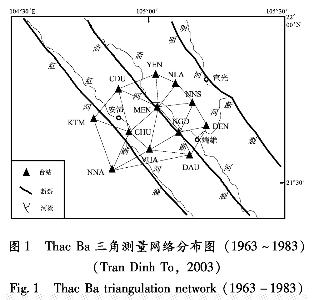
从20世纪50年代开始,国内对跨红河断裂带及其相邻地区进行了大量的形变观测。水平形变监测网主要由三角网和GPS观测网组成。
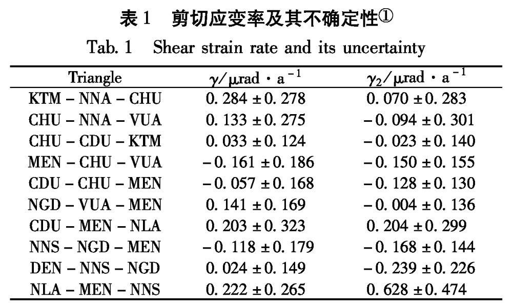
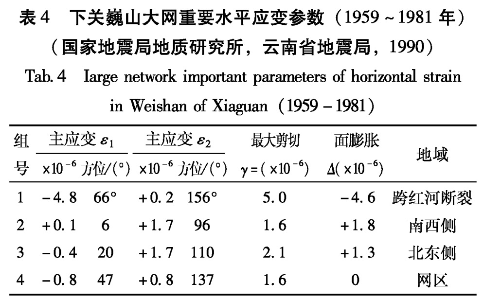
表4 下关巍山大网重要水平应变参数(1959~1981年)
(国家地震局地质研究所,云南省地震局,1990)
Tab.4 Iarge network important parameters of horizontal strain in Weishan of Xiaguan(1959-1981)
(1)三角网形变观测及其特征分析
滇西北地区水平形变监测三角网(1959~1988)在该区水平形变数据采集中,由于重新平差精度降低,对老边长(20世纪50年代施测的三角测量成果)一般采用原整体平差结果; 而对新边长(即激光测距成果),一般都进行边长投影计算,伪逆平差计算。
由表4可看出,第一组以跨红河断裂带测边线应变组合计算,其最大剪切取最高值(5×10⁻⁶),与西部地域(1.6×10⁻⁶)和东部地域的(2.1×10⁻⁶)相比较,它是测区内最为明显的活动断裂,而且从平均趋势看以右旋运动为主。根据阳世华等(1983)的计算,本网区总应变主张明显大于主压,给出了更加明确的断裂活动特征。剑川—巍山大网布设在本研究区的北部。从测量资料分析,它主要反映了龙蟠—乔后断裂的南段,反映其左旋运动性质。
在剑川—洱源大网中,选用跨红河断裂带(洱海断裂北段)测边线应变进行应变参数的组合计算,覆盖洱源的三角形网给出红河断裂带的右旋活动特征; 仅用跨红河断裂带的测边计算,最大剪切达2.1×10⁻⁵,这个量级比龙蟠—乔后断裂的剑川地段还稍大一些。这反映洱源北段比较狭窄的范围内右旋运动性质。
(2)GPS网形变观测及其特征分析
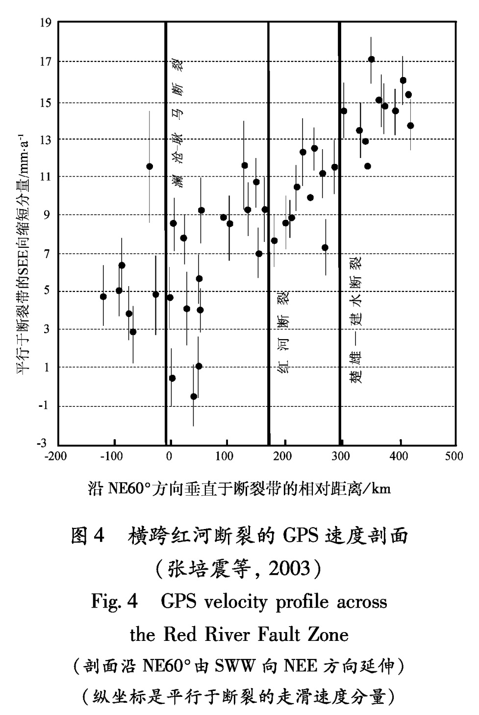
张培震等(2003)研究认为,川滇地区GPS观测结果揭示了红河断裂可能具有右旋走滑的运动方式,但右旋走滑不是沿着红河断裂带发生的,而是沿着楚雄—建水断裂、红河断裂和澜沧—耿马断裂共同发生,形成一条宽达300 km的右旋剪切带,其右旋走滑速率可达(10±3)mm/a(图5)。就红河断裂带本身而言,右旋走滑速率可能只有(3~4)mm/a,与活动断裂研究结果类似。
沿NE60°方向垂直于断裂带的相对距离/km
图4 横跨红河断裂的GPS速度剖面
(张培震等, 2003)
Fig.4 GPS velocity profile across the Red River Fault Zone
(剖面沿NE60°由SWW向NEE方向延伸)
(纵坐标是平行于断裂的走滑速度分量)
张清志等(2006)利用1999年和2003年红河断裂的GPS观测资料,通过数据反演获得在欧亚参考框架下的速度矢量图。结果表明:在欧亚框架下,东向分量平均速度为3.726 mm/a,北向分量平均速度为-9.013 mm/a; 由北向南,各测站的北向分量速率值逐渐减小,由西向东,各测站的东向分量速率值逐渐减小,测区内呈现明显的右旋拉张走滑运动。分析表明云南红河地区地壳水平运动的特征以及断裂活动性质与构造地质高度吻合。
王阎昭等(2008)在没有设置红河断裂带断层单元的情况下得到很小的GPS速度场残差,说明这些断裂在现今可能不活动或活动性很弱。前人大量研究表明其晚更新世以来有明显的活动。但我们的反演结果显示红河断裂现今活动不强,其北西段右旋走滑活动和挤压活动分别为(0.4±1.6)mm/a和(1.5±1.3)mm/a,中段右旋走滑活动和拉张活动分别为(0.3±1.3)mm/a和(1.0±1.5)mm/a,南东段左旋走滑活动和挤压活动分别为(1.5±2.7)mm/a和(1.3±2.0)mm/a,与前人研究结果相比基本一致。事实上近些年的地震分布也显示红河断裂现今表现相当平静。
红河断裂是川滇活动地块的西南边界,研究表明其新生代早期的运动以左旋走滑为主,后期转变为右旋走滑。断裂北段由一系列具有很大拉张分量的右旋走滑正断层所组成,晚第四纪到现今构造活动强烈,控制了一系列历史强震的发生,如1993年丽江7.3级地震。断裂南段结构比较简单,以沿红河河谷发育的走滑断裂为主,有历史记载以来没有强震发生。虢顺民等(2001)估计该断裂晚第四纪滑动速率为1~3 mm/a。
以上研究表明红河断裂带在中国境内的平均水平运动速率约为1~4 mm/a。
2.2 垂直形变基本特征
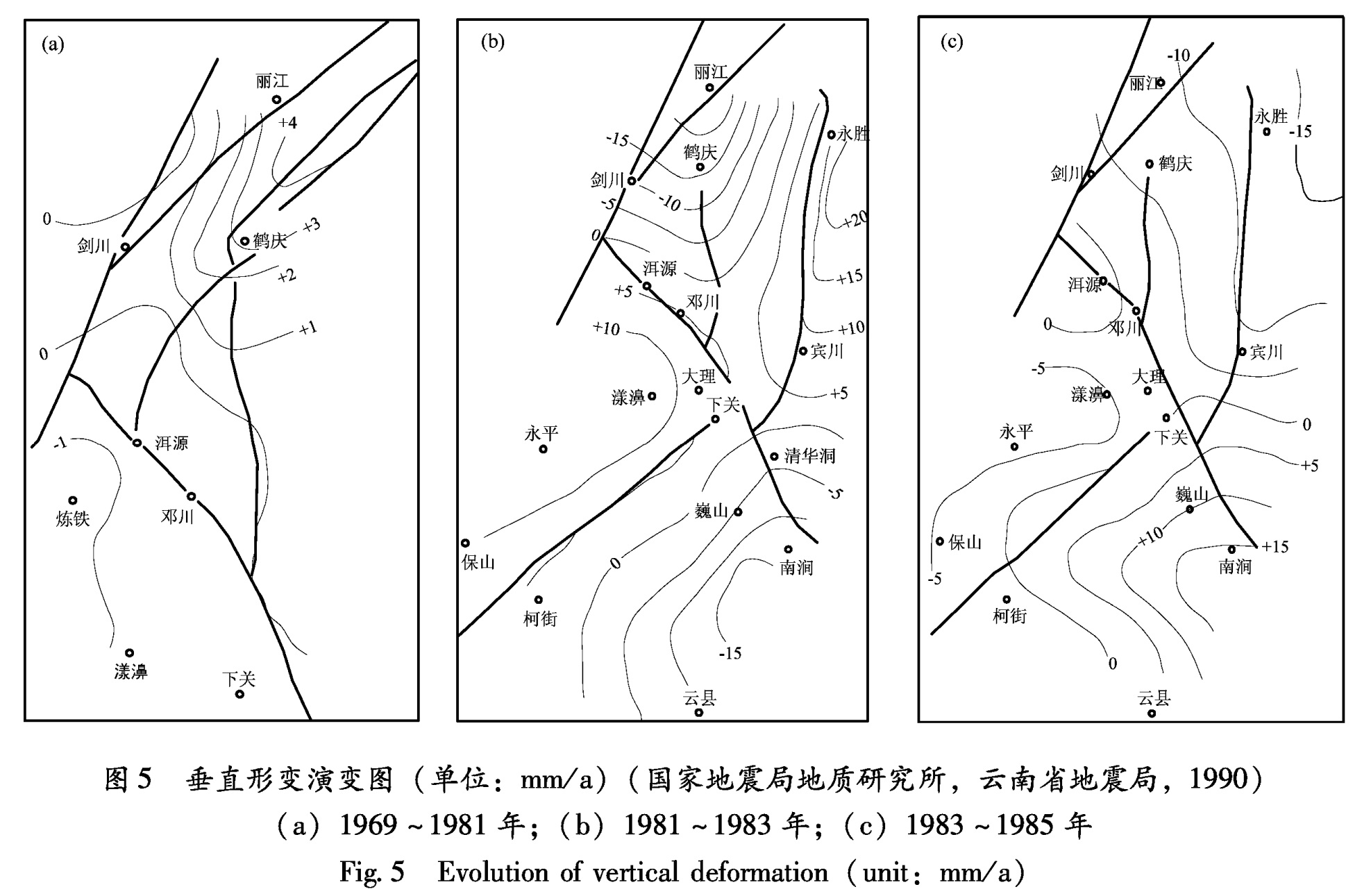
根据1981~1983年测量资料(图5b),垂直形变场的对称位置表现在洱源、邓川、下关一带。国内地震专家认为这一时段的形变场特征反映了红河断裂带的单一活动性:东侧为北降南升,西侧为南降北升。这种垂直形变的四象限分布特征,使专家们得出两个重要的结论:①红河断裂带发生了东盘向南、西盘向北的推进运动,丽江、鹤庆地区处于拉张下沉部位; ②水平运动使断裂后段拉张下沉,前段挤压抬升,洱源以南的邓川地区处在枢纽部位,从而产生垂直应变的积累。
图5b可以看出,这种垂直形变特征是有其构造活动背景的。红河断裂带以东的垂直形变显然受程海断裂带以及鹤庆—洱源断裂活动的控制; 红河断裂带西侧的垂直形变显示受到了北东向活动断裂的控制。
由1983~1985年测量资料(图5c)可以看出红河断裂带在这一期的活动。其垂直形变的对称部位基本上与图5b相同,但运动方向已有转向,对称轴亦有偏转。永胜、宾川地区形变恢复,但丽江、鹤庆地区仍继续下沉,说明本区的活动水平没有减弱。
图5 垂直形变演变图(单位:mm/a)(国家地震局地质研究所,云南省地震局,1990)
(a)1969~1981年;(b)1981~1983年;(c)1983~1985年
Fig.5 Evolution of vertical deformation(unit:mm/a)
如果将图5b和图5c数值相减,可以明显看出它的形变波动,其总体趋势与图5a基本一致。说明滇西北地区龙蟠—乔后断裂带和红河断裂带的活动是连续的,并基本上是定向的(虢顺民等,2001年)
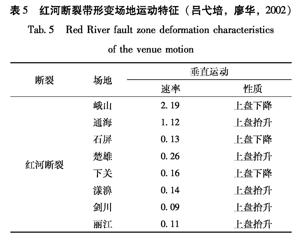
由表5和图6可以看出:红河断裂带各场地的形变活动差异较大,石屏、楚雄、下关、丽江、剑川等5个场地,一直处于较低活动水平。在测点周围几次强烈地震前后,也未表现出大的形变。而峨山、通海、漾濞等3个场地一直处于较高活动水平。
表5 红河断裂带形变场地运动特征(吕弋培,廖华,2002)
Tab.5 Red River fault zone deformation characteristics
of the venue motion
断裂 场地 垂直运动速率 性质 峨山 2.19 上盘下降 通海 1.12 上盘抬升 石屏 0.13 上盘下降红河断裂 楚雄 0.26 上盘抬升 下关 0.16 上盘下降 漾濞 0.14 上盘抬升 剑川 0.09 上盘抬升 丽江 0.11 上盘抬升
图6 各测点不同时段垂直运动速率图(吕弋培,2002)(a)1995~2000年;(b)1990~1995年;(c)1985~1990年;(d)1980~1985年
Fig.6 Vertical movement rate of different time section in different measuring points
不同时期,表现出不同的运动特征,变化大的场地在1980~1990年期间,处于较高活动水平,在1990~1995年期间运动速率普遍降低,1995~2000年期间又恢复较高的活动水平(
图5)。石屏-下关段的垂直运动速率是(0.13~0.26)mm/a,而峨山、通海的垂直运动速率则为(1.12~2.19)mm/a。在红河断裂带上,有两段的运动特征异于该断裂的地质运动方向,即下关—剑川段和通海—石屏段,这些异常运动段的出现,表明该区域存在较大的断层闭锁区,也是构造应力积累区,这些区域将是未来地震发生的重点危险区(吕弋培等,2002)。
苏琴(2005)通过对川滇菱形块体的跨断层形变测点长达20年的观测资料进行处理,计算出每一水准测点的年变化速率平均值,并根据垂直形变速率计算结果对断层活动方式进行分析,得出了各测点的垂直形变速率及断层活动方式:
位于块体西南边界的红河断裂带,其垂直形变速率差异很大,该断裂北段的漾濞场地平均速率达5.46 mm/a,此处断层长期处于高速蠕滑运动状态。而其余场地除丽江测点的垂直形变年速率大于0.50 mm/a外,其他场地年速率均较小。红河断裂带受其地质构造影响,断层活动性较复杂,北段以压性为主,南段(曲江段)则以张性为主。
以上研究表明,红河断裂带在中国境内的垂直形变速率约为(0.09~5.46)mm/a。