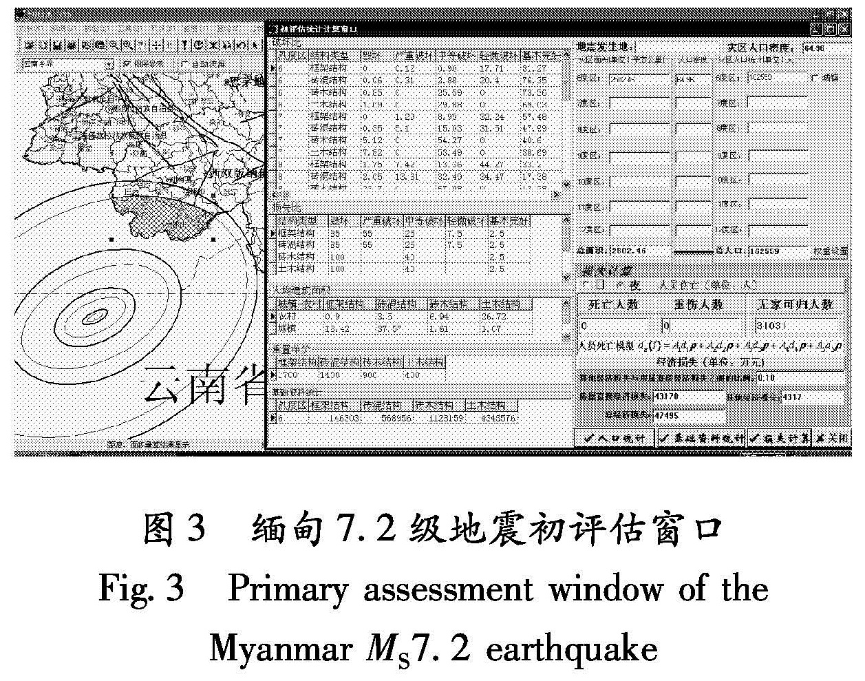
1.1 直接经济损失评估计算
当破坏性地震发生以后,根据地震三要素(时间、地点、震级),依据灾区历史地震的震害资料及烈度衰减关系,同时结合灾区构造背景、震源机制解、震源破裂过程、余震序列分布等资料,快速将地震烈度等震线绘制出来; 再结合灾区历史地震的震害矩阵、重置单价以及基础资料数据库快速统计、计算出的灾区内各类房屋总面积,遵照国家标准《地震现场工作第4部分:灾害直接损失评估》(GB/T18208.4-2005)规定,计算各评估子区各类房屋在某种破坏下的直接经济损失Lh为
Lh=Sh×Rh×Dh×Ph.(1)
即:房屋破坏经济损失=房屋建筑总面积×破坏比×损失比×建筑单价。
在初评估工作中,房屋直接经济损失评估的模型及原理与现场损失总评估相同,但要在震后数小时或1~3天内给出损失评估结果,就要求在无现场调查或有限的现场调查情况下快速获取(1)式中的房屋建筑总面积S、破坏比R、损失比D和建筑单价P。
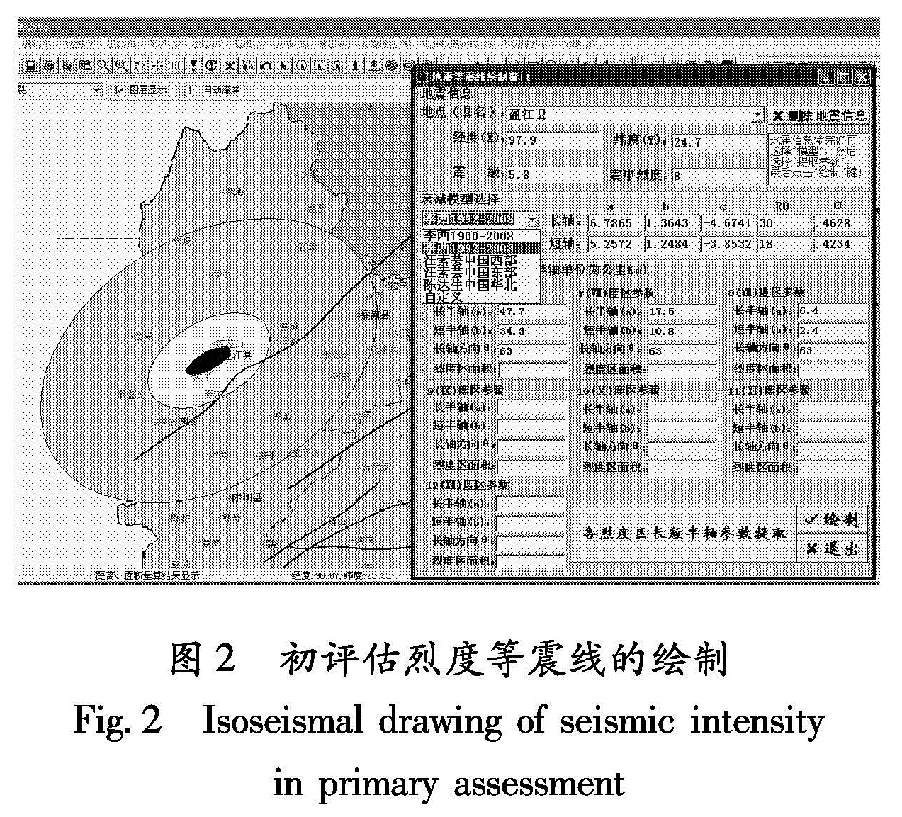
1.1.1 云南地区烈度衰减关系研究
烈度衰减关系的确定是初评估工作中灾区面积、人口以及各类房屋建筑面积统计、计算的基础。汪素云等(2000)通过对中国西部历史地震资料研究,得到了中国西部烈度衰减关系。笔者发现,在云南地区6级以下地震使用西部烈度衰减模型绘制的烈度等震线,尤其是在开展灾评工作以后得到的烈度等震线范围与实际地震烈度等震线范围有较大出入。李世成等(2003)对云南地区烈度衰减关系进行了研究,得到了云南分区烈度衰减关系,李永强和王景来(2007)在研究中也引用此衰减关系。但笔者对云南分区烈度衰减关系给定烈度及震级,并计算烈度等震线半径时,发现所得烈度半径值远大于理论及实际调查结果,因此没有采用该模型。
基于以上原因,笔者选用1913~2008年在云南省境内及周边发生的140个破坏性地震(MS≥4.7),其中:4.7≤MS≤4.9地震7个; 5.0≤MS≤5.9地震89个; 6.0≤MS≤6.9地震37个; 7.0≤MS≤7.7地震7个。用140个地震的烈度等震线资料进行了回归分析,得到了云南地区的烈度衰减关系如下:
Ia=5.4154+1.2792M-3.8738lg(Ra+21),
σ=0.5204;
Ib=3.3421+1.1719M-2.8268lg(Rb+7),
σ=0.4931.(2)
式中,Ia、Ib分别表示长、短轴烈度; M表示震级; Ra、 Rb分别是指烈度为I时烈度圈的长、短半轴的长度; σ为标准差。
1.1.2 震后1~2小时内的房屋直接经济损失评估
在震后无现场调查资料的情况下,(1)式中的破坏比R、损失比D,可以通过研究灾区或其邻区历史地震震害矩阵得到。建筑单价P可以参照近期灾区或邻区地震的各类建筑单价进行取值,对于房屋建筑总面积S,可由下式求得
Sij=Gi×σpi×Spj+Gi×σci×Scj.(3)
式中,Sij表示第i个评估区,第j种结构房屋的面积; Gi表示第i个评估区的人口,可由云南地区烈度衰减关系式(2)绘制的烈度等震线及基础数据库快速求得; σpi表示第i个评估区非城镇人口所占评估区总人口的百分比; σci表示第i个评估区城镇人口所占评估区总人口的百分比; Spj表示第j种结构非城镇人口人均的建筑面积,Scj表示城镇人口人均第j种结构的建筑面积,其值都可根据课题组成员对云南地区典型区域房屋结构调查资料统计得到。
1.1.3 震后1~3天内的房屋直接经济损失评估
在震后1~3天内,在现场初步调查的基础上开展初评估时,因在短时间内无法根据现场调查得到(1)式中的房屋建筑总面积S,同样可以参考式(2)计算方法,式(3)中的参数可以根据现场调查情况作相应调整; 损失比D参考现场调查规范取值; 建筑单价P从灾区现场调查中获得; 破坏比R的计算方法与总评估时不同,采用加权平均方法确定,首先由评估专家依据抽样点的代表性与抽样质量确定评估区各抽样点的权系数,然后计算该评估区建筑物的破坏比(王晓青,丁香,2004)。
1.1.4 其他直接经济损失评估
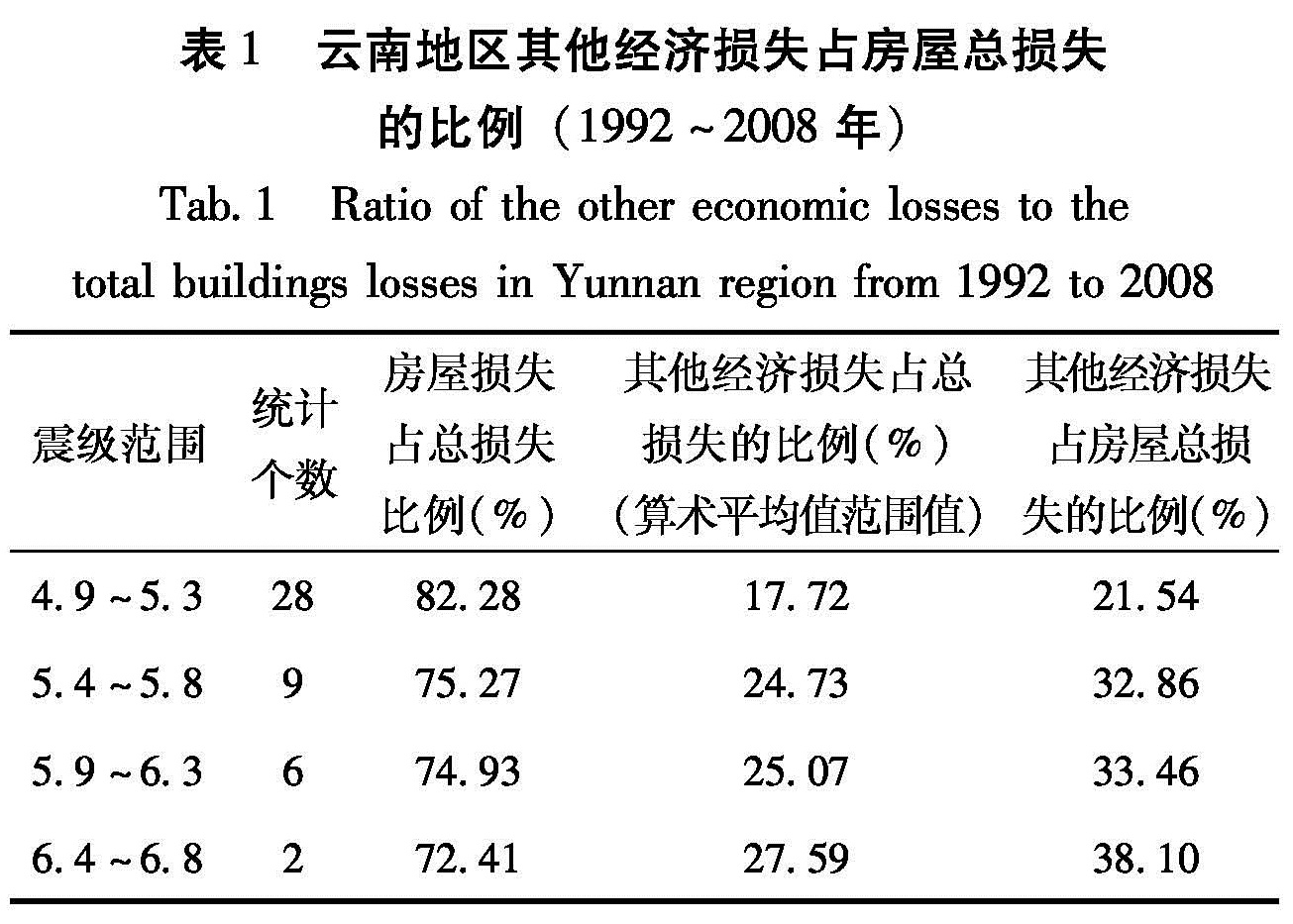
根据历史地震统计其他(生命线、水利、区外等)直接经济损失,分析其占房屋直接经济损失的比例关系,从而快速估算出其他直接经济损失,云南地区其他经济损失与房屋总损失的比例见表1。
房屋直接经济损失与其他直接经济损失之和即为此次地震造成的直接经济损失(晏凤桐,2003)。
表1 云南地区其他经济损失占房屋总损失
的比例(1992~2008年)
Tab.1 Ratio of the other economic losses to the
total buildings losses in Yunnan region from 1992 to 2008
1.2 人员伤亡估计模型
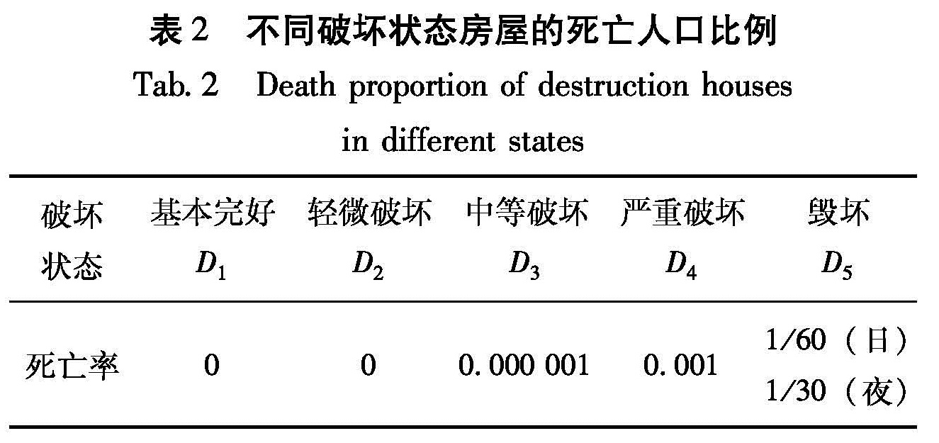
(1)死亡人数估计模型
dn(I)=A1d1ρ+A2d2ρ+ A3d3ρ+ A4d4ρ
+A5d5ρ.(4)
式中,dn(I)为预测区内地震烈度为I时的死亡人数; A1,…,5表示建筑物破坏状态为D1,…,5的总面积; d1,…,5表示建筑物破坏状态为D1,…,5时,建筑物内部人口的死亡率(表2); ρ为单位面积人数(预测区内总人口/房屋总面积)。各烈度区死亡人数之和即为地震造成的总的死亡人数(尹之潜,1995)。
表2 不同破坏状态房屋的死亡人口比例
Tab.2 Death proportion of destruction houses
in different states
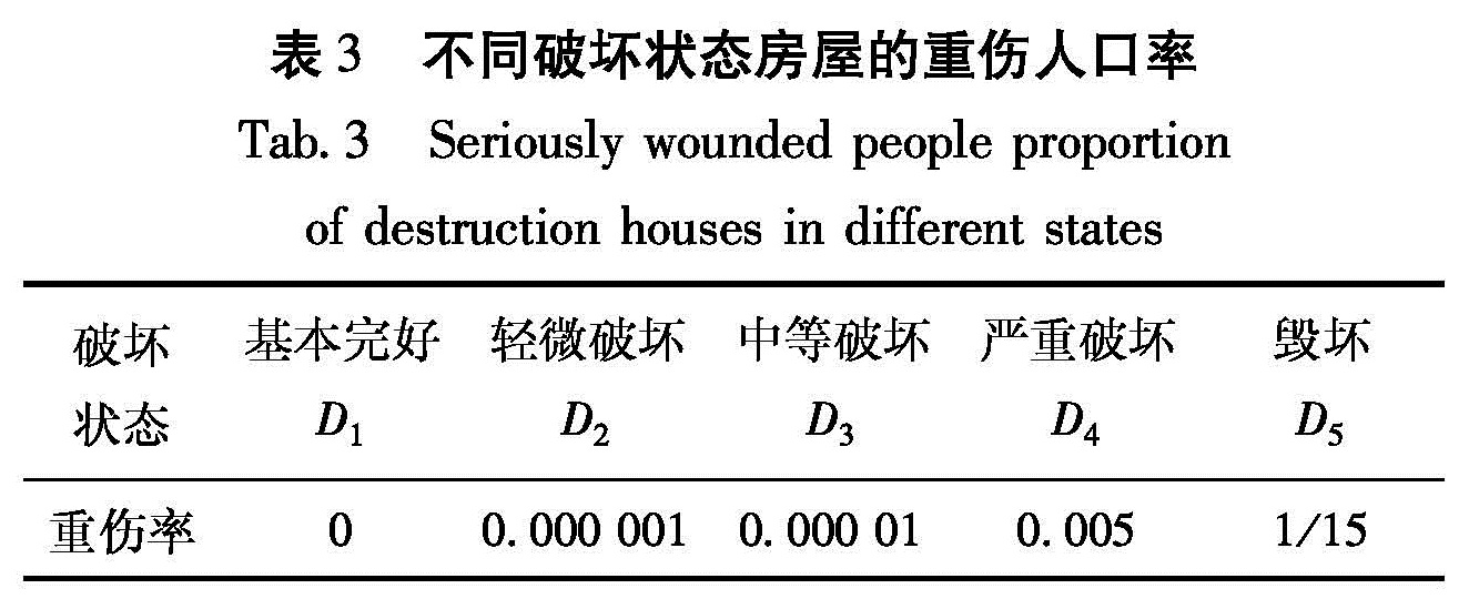
(2)重伤人数估计模型
hn(I)=A1h1ρ+ A2h2ρ+ A3h3ρ+ A4h4ρ
+ A5h5ρ.(5)
式中,hn(I)为预测区内地震烈度为I时的重伤人数; A1,…,5表示建筑物破坏状态为D1,…,5的总面积; d1,…,5表示建筑物破坏状态为D1,…,5时,建筑物内部人口的重伤率(表3); ρ为单位面积人数。各烈度区重伤人数之和即为地震造成的总的重伤人数(尹之潜,1995)。
表3 不同破坏状态房屋的重伤人口率
Tab.3 Seriously wounded people proportion
of destruction houses in different states
1.3 失去住所人数预测模型
HLn(I)=(A5+A4+7A3/10)/ a-dn(I).(6)
式中,HLn(I)是烈度为I时预测区内需安置的人数; a为预测区内人均居住面积,单位是m2; A5,4,3分别表示发生D5、D4、D3级破坏的居住房屋面积,单位是m2; dn(I)为预测区内地震烈度为I时的死亡人数,由(4)式求得。各烈度区需安置人数之和即为地震造成的总的需安置人数(尹之潜,1995)。
(4)~(6)式中,D1、 D2、D3、D4、D5分别表示:基本完好、轻微破坏、中等破坏、严重破坏和毁坏。