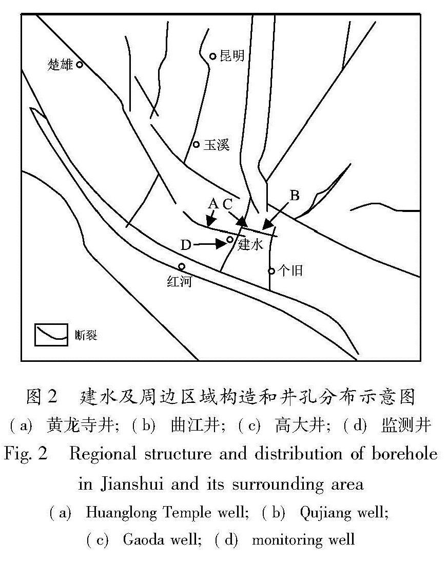
建水县地处川滇菱形块体南端,构造复杂,是一个地震多发的地区,特别是北部的曲江断裂、中部的石屏—建水断裂对建水县的区域稳定影响巨大。因此笔者首先重点对比分析了位于这两条断裂带上和周边市(县)井孔的水位观测数据(图2)。
2.1 周边观测井水位对比分析
如果是构造活动引起的水位突降,有可能在建水附近的断裂带或观测井上观测到相似的变化特征,因此笔者对比分析了相同时段内相关井孔的观测资料。
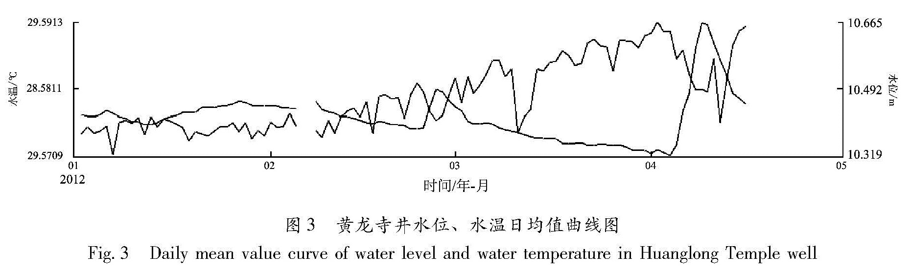
(1)建水黄龙寺井水位、水温
位于石屏—建水断裂带上的建水黄龙寺井水位正常动态为年变型,与降雨量相关,雨季上升,旱季下降。同井观测的水温,其正常动态也为年变型,雨季下降,旱季上升,与水位呈负相关(图3)。
图2 建水及周边区域构造和井孔分布示意图
(a)黄龙寺井;(b)曲江井;(c)高大井;(d)监测井
Fig.2 Regional structure and distribution of borehole in Jianshui and its surrounding area(a)Huanglong Temple well;(b)Qujiang well; (c)Gaoda well;(d)monitoring well
图3 黄龙寺井水位、水温日均值曲线图
Fig.3 Daily mean value curve of water level and water temperature in Huanglong Temple well
从图3可见,2011年11月至2012年4月初,黄龙寺井水位总体呈下降趋势,降幅为0.3 m,与本地区跨年的旱情相吻合,没有出现大幅度的水位骤降异常,对比观测的水温也可得出相同的结论。2012年4月6日,当地降雨,黄龙寺井水位也随之上升,至4月10日升幅达0.4 m以上。4月6日以后,井孔水位正好处于上升阶段(月变)。月变与降雨导致涨幅叠加,造成0.4 m的水位变化。
(2)建水曲江井水位
由图4可见位于曲江断裂带上曲江井,2012年以来的水位观测动态变化也没有发现骤降异常。
图4 曲江水位日均值曲线
Fig.4 Daily mean value curve of water level in Qujiang well
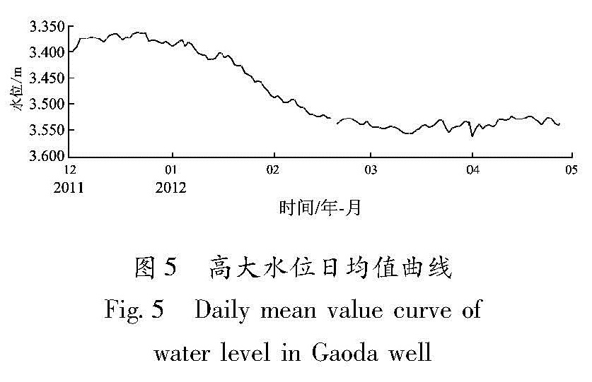
(3)通海高大水位
由图5可见,位于曲江断裂带上的通海高大井水位有小幅下降,从2012年1月到3月中旬降幅累计达0.2 m,应属旱季水位的正常下降,没有突降异常。
图5 高大水位日均值曲线
Fig.5 Daily mean value curve of water level in Gaoda well
笔者还对比了大姚、南华、峨山、弥勒、元江、易门、开远井的观测资料,认真分析了与建水监测井水位骤降时段(2012年2月底至3月底)的同期变化,基本排除了构造活动相关的可能。易门、开远水位连续几年持续下降,有可能是近年的干旱所致(林辉等,2011),也可能是另一种异常,但本文主要是针对监测井的突降进行讨论,在此不进行分析。
当构造活动引起水位观测微动态异常时,同一构造上有可能观测到地下水的宏观异常(国家地震局预测预报司,1997),近期,在建水县宏观联络网中,也未接到任何与地下水相关的宏观异常的报告。
根据上述分析,基本排除建水监测井水位骤降是由构造活动引起的。
2.2 邻近抽水井、建筑施工和地下灌浆情况调查
排除了构造活动的影响,监测井水位骤降可能是人为活动造成的。为探究原因,笔者对建水城区的井孔情况进行了详细的调查、分析。
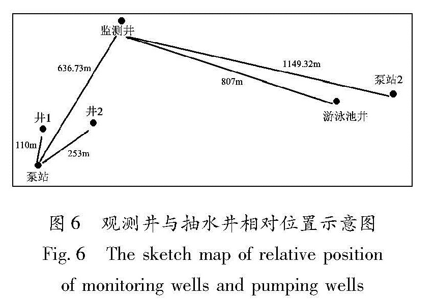
图6 观测井与抽水井相对位置示意图
Fig.6 The sketch map of relative position of monitoring wells and pumping wells
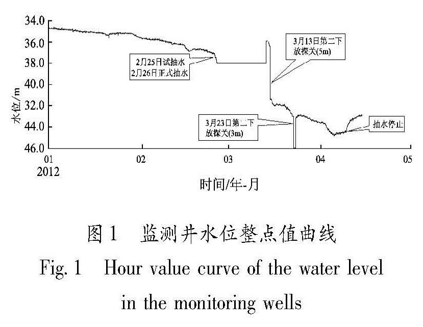
调查发现,以建水监测井为中心1.5 km范围内还有5口机井,其中有两口井未使用(未标出),两口井间歇抽水(游泳池井和泵站2井),一口井(泵站井)从2月底开始持续抽水。2月中旬,监测井旁60 m外开始进行艺术体育馆的建筑施工,主要是地面钢结构安装,对地下水位无影响; 监测井周围1.5 km范围内未发现地下灌浆作业。
2.3 抽水井基本情况
(1)游泳池井:井口高程1 311 m,距观测井807 m。开孔口径383 mm,终孔口径273 mm,井深130.79 m,井孔揭穿的地层分别为:0~1.0 m,第四系(Q4)砂质粘土; 1.0~39.00 m,第三系(N)泥岩砂质含砾石粘土层互层; 39.00~130.79 m,石炭系(C1y)灰岩,局部破碎,裂隙较发育,有明显的溶蚀现象。溶蚀新鲜面多见,填充物少见。
抽水实验结果:井水位降幅8.77 m、涌水量33.10 L/s、含水层渗透系数12.39 m/d。
(2)泵站2井:井口高程1 309 m,距观测井1 149.23 m。开孔口径500 mm,终孔口径273 mm,井深201.10 m,井孔揭穿的地层分别为:0~2.74 m,第四系(Q4)砂质粘土; 2.74~44.09 m,第三系(N)泥岩、砂质含砾石粘土层; 44.09~201.10 m,石炭系(C1y)灰岩及灰质白云岩,溶蚀强烈,溶孔、溶洞较多,岩芯多呈碎块状或短柱状。
抽水实验结果:井水位降深19.70 m、涌水量38.89 L/s、含水层渗透系数11.4 m/d。
(3)泵站井:井口高程1 311 m,距观测井636.73 m,为3口井(A、B、C)组成的井群,井间间距15 m,呈“品”字状展布。A井:开孔口径529 mm,终孔口径225 mm,井深230.56 m; B井:开孔口径529 mm,终孔口径225 mm,井深200.00 m; C井:开孔口径529 mm,终孔口径225 mm,井深230.00 m。井孔揭穿的地层分别为:0~14 m,第四系(Q4)砂质粘土; 14~129 m,第三系(N)泥岩、砂质含砾石粘土层; 129~230.56m,泥盆系上统(D3t)灰岩及灰质白云岩,局部破碎,裂隙较发育,有明显的溶蚀现象。岩溶发育。
抽水实验结果:井水位降深5.32 m、涌水量32.03 L/s、含水层渗透系数24.16 m/d。
在监测井的西南部约400 m处还有两口潜水井:“小节井”(井1)和“大坂井”(井2)。两口井与泵站井的距离分别是110 m和252 m(图3)。
2.4 水文地质概况
建水县域内地下水有松散堆积层孔隙水、碎屑岩裂隙孔隙层间水、碳酸盐岩裂隙溶洞水和基岩裂隙水4种类型,并普遍存在于土壤及各类岩层中。建水盆地因地形较低利于水流汇集且下伏岩层为可溶性较好的碳酸盐岩(泥盆系、石炭系的灰岩、白云质灰岩),是碳酸盐岩裂隙溶洞水和基岩裂隙水很好的赋存空间,从地下水补给、径流、排泄的区段上看,建水盆地还是裂隙溶洞水的排泄区,使得这一区域成为建水县境内最好的富水块段和水源地。
监测井、泵站井、游泳池井、泵站2井均处于盆地的富水块段中,属同一水文地质单元。