板块运动有其自身的规律,在地震活动平静期,可以获得比较稳定的运动速度,该速度可以认为是正常活动背景。分析地壳运动与地震的关系需要两个步骤,第一步明确正常活动背景,第二步查找地震前是否有与长趋势相背离的异常运动。当然,出现地壳运动反向也不一定意味着这一区域一定就会发生地震,但它能代表这一区域为应力增强明显的地区,因此,该区域是否具有发震的危险性还需结合断层分布特征进行分析,如果出现了背离长趋势背景的地壳运动,但断层周边区域的运动一致性较好,那么,这一区域发生地震的危险性不高。反之,如果断层两侧运动一致性较差,则需要引起特别关注。
2.2 短期形变特征分析
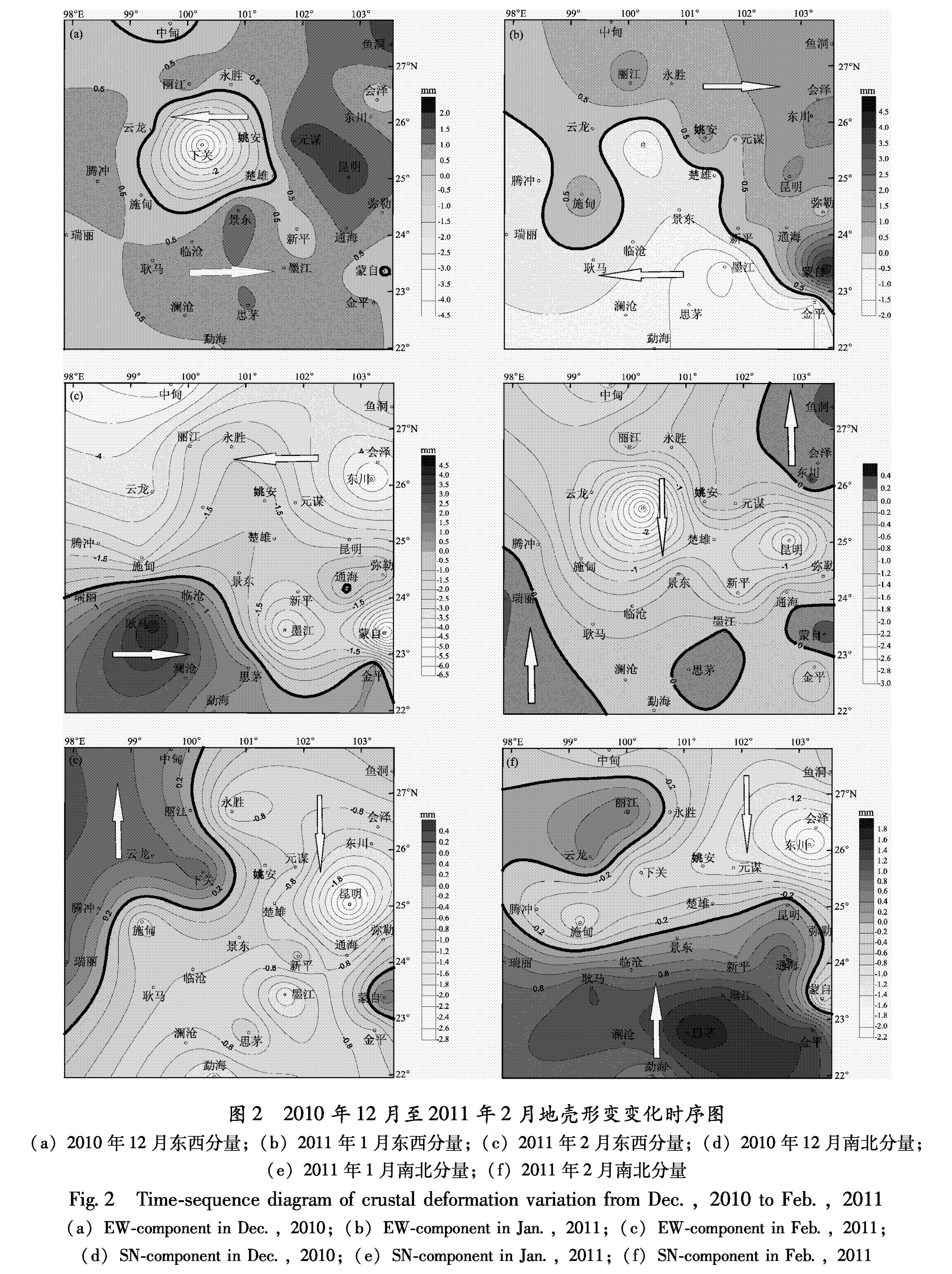
根据以上分析,云南省内的区域运动在以文山为位移基准的前提下,正常的运动方向应该是南向和西向,如果部分点位出现了北向运动或者是东向运动,则可以认为是异常。由于点位相对变化实际解算精度在单一方向上能够达到±1.5 mm,大于该精度的变化量可以认为是真实的。因此,以一个月为窗长进行等值线图的绘制,设定东向、北向运动为正值,用深色进行填充,代表了异常区域。西向、南向运动为负值,代表正常运动,用浅色表示,运动方向反向交界线用加粗线条表示。
(1)盈江5.8级地震与区域形变关系分析
盈江地震的发震断层为北东向断裂,为了避免同震形变引起的区域形变速率异常,本文主要分析地震前的形变速度图像,图2为盈江5.8级地震前3个月(2010-12-18~2011-02-17)的东西和南北分量变化时序。
图2 2010年12月至2011年2月地壳形变变化时序图
(a)2010年12月东西分量;(b)2011年1月东西分量;(c)2011年2月东西分量;(d)2010年12月南北分量;
(e)2011年1月南北分量;(f)2011年2月南北分量
Fig.2 Time-sequence diagram of crustal deformation variation from Dec.,2010 to Feb.,2011(a)EW-component in Dec.,2010;(b)EW-component in Jan.,2011;(c)EW-component in Feb.,2011;(d)SN-component in Dec.,2010;(e)SN-component in Jan.,2011;(f)SN-component in Feb.,2011
从图2可以看到,区域应力变化所引起的形变传递过程比较清晰,2010年12月,云南省内北东向推挤加强,除下关点以外,其他区域全部为东向运动,南北向运动的异常区域集中在云南西南角瑞丽一带地区。2011年1月,该推挤力量有所减退,东向运动异常区域范围缩小,主要分布在红河断裂以北地区,2011年2月,云南南部再次出现了明显的北东向异常运动。
综合分析,由于云南省内长趋势的应力相对平衡状态被打破,区域内的主导应力出现短期变化,导致了较大的区域形变异常。在2011年2月,腾冲、施甸一带地区出现两个分量零值线在施甸一带相交的现象。根据这些现象可以推测,耿马一带再次受到明显的北东向推挤,瑞丽、耿马一带呈现北东方向运动趋势,而其北边的腾冲、施甸一带由于受来自东北方向的应力作用,出现了南西向运动,使得这一地区在运动方向上出现了反向剪切,从耿马至腾冲一带的运动量差值达到了5 mm左右,在腾冲、施甸、瑞丽等地区形成了较大的剪切应力,这可能成为了前期应力积累释放的诱因。因此,我们认为2011年3月10日盈江5.8级地震与此形变异常存在因果关系。
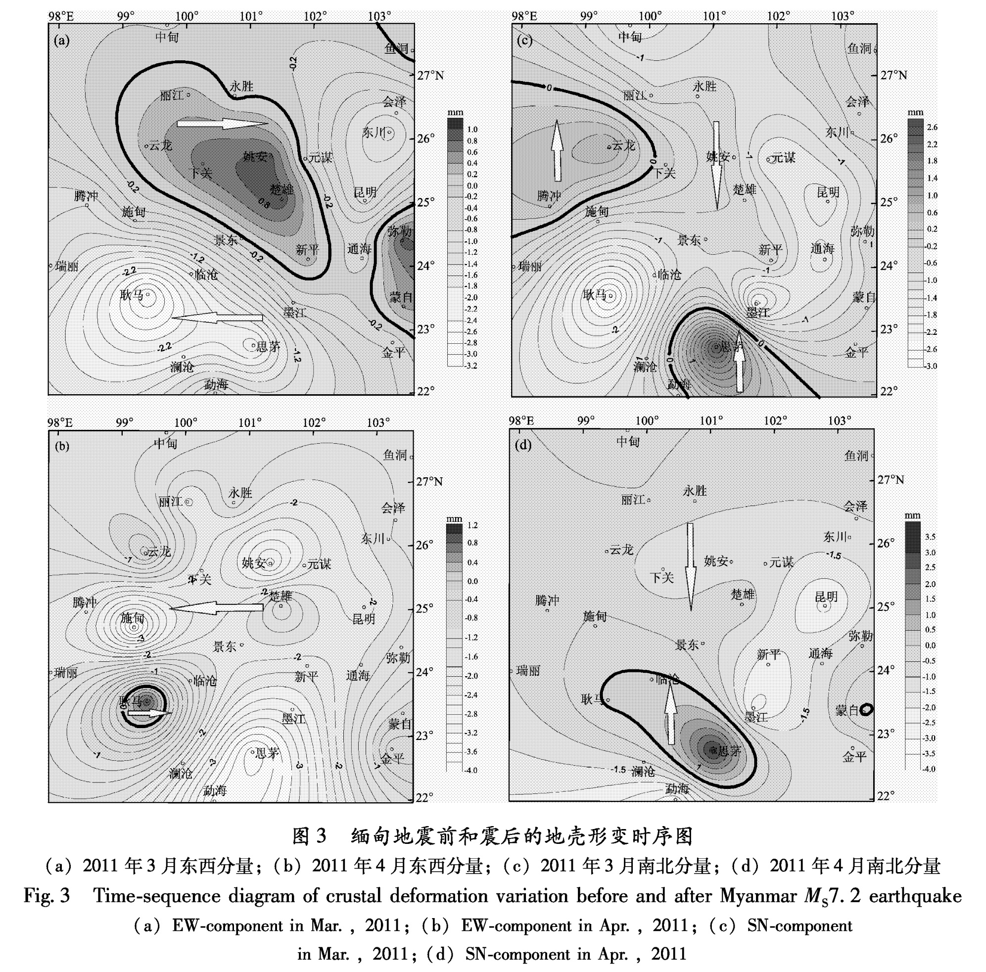
(2)缅甸7.2级地震与区域形变关系分析
根据中国地震台网测定:2011年3月24日21时55分在缅甸(20.8°N,99.8°E)发生MS7.2地震,震中位于缅甸掸邦(Shan State)。断层总体走向为NEE向,断层性质为左旋走滑。
图3 缅甸地震前和震后的地壳形变时序图
(a)2011年3月东西分量;(b)2011年4月东西分量;(c)2011年3月南北分量;(d)2011年4月南北分量
Fig.3 Time-sequence diagram of crustal deformation variation before and after Myanmar MS7.2 earthquake(a)EW-component in Mar.,2011;(b)EW-component in Apr.,2011;(c)SN-component in Mar.,2011;(d)SN-component in Apr.,2011
由于该地震发生在境外,没有理想的观测点来解释这一地震过程,但该地震震级较大,周边地区应该会有所反应。图2和图3a、c为震前图像,图3b、d为震后图像,震前思茅一带地区有较长时间内存在着北向运动异常,最大达1.6 mm。震后思茅地区出现了明显的震后变形,思茅地区测点沿澜沧江断裂向西北方向运动,应该是发震断层的左旋走滑运动导致其右盘产生了北北东向推挤的结果。
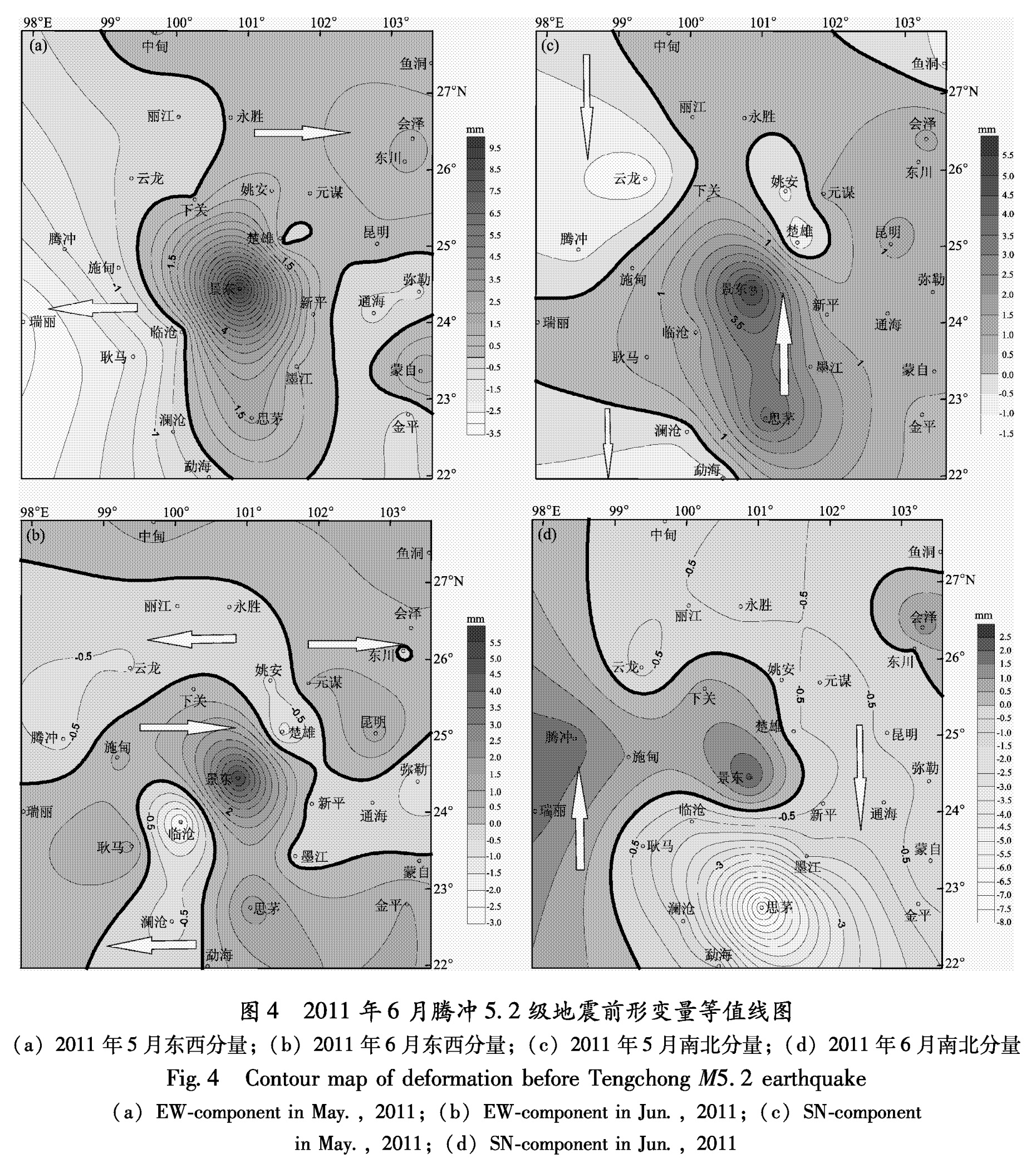
(3)2011年6月腾冲5.2级地震与区域形变关系分析
2011年6月20日发生腾冲5.2级地震,从图4可以看出(2011-04-17~2011-06-17),2011年4~5月,受到缅甸地震的影响,震后思茅、墨江以及小江断裂一带仍然表现为东向运动,省内大部分区域表现为北向运动。5~6月期间,思茅一带地区的北向运动已经消失,转向了南向正常运动,而腾冲、施甸、瑞丽一带地区出现了明显的北向运动,视为异常,且从东西分量来看,在大盈江断裂的两侧出现了明显的反向剪切运动,因此,我们认为此次腾冲5.2级地震前存在明显的形变异常。
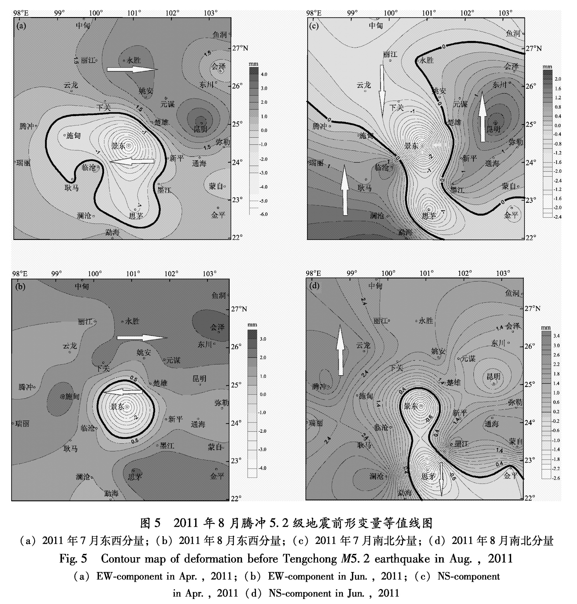
(4)2011年8月腾冲5.2级地震与区域形变关系分析
图4 2011年6月腾冲5.2级地震前形变量等值线图
(a)2011年5月东西分量;(b)2011年6月东西分量;(c)2011年5月南北分量;(d)2011年6月南北分量
Fig.4 Contour map of deformation before Tengchong M5.2 earthquake (a)EW-component in May.,2011;(b)EW-component in Jun.,2011;(c)SN-component in May.,2011;(d)SN-component in Jun.,2011
2011年8月10日,腾冲再次发生了5.2级地震。由震前形变量等值线图(2011-06-10~2011-08-09)(图5)可以看到,西南方向的挤压应力在6月发生腾冲5.2级地震后仍然存在,省内除景东、思茅一带为正常运动以外,其他地区均为东北或东南向运动。7~8月期间,腾冲一带地区的北向运动加强,省内东向运动区域扩大,大盈江断裂两侧东向和北向运动量均出现差异。因此,北东向的应力加强,导致小滇西地区的持续受压,压力对不同区域产生的形变量差异是这一地震发生的主要原因。
图5 2011年8月腾冲5.2级地震前形变量等值线图
(a)2011年7月东西分量;(b)2011年8月东西分量;(c)2011年7月南北分量;(d)2011年8月南北分量
Fig.5 Contour map of deformation before Tengchong M5.2 earthquake in Aug.,2011(a)EW-component in Apr.,2011;(b)EW-component in Jun.,2011;(c)NS-component in Apr.,2011(d)NS-component in Jun.,2011