基金项目:中国地震局地质研究所基本科研业务费项目(重点)(IGCEA1220):鄂尔多斯西缘及邻区构造活动、变形模式与强震机理资助.
(Earthquake Administration of Ningxia Hui Autonomous Region,Yinchuan 750001,Ningxia,China)
earthquake; active fault; buffer analysis; overlay analysis; GIS; Yinchuan Basin
备注
基金项目:中国地震局地质研究所基本科研业务费项目(重点)(IGCEA1220):鄂尔多斯西缘及邻区构造活动、变形模式与强震机理资助.
在建立了银川盆地活动断裂和地震资料数据库的基础上,利用缓冲区分析、叠加分析和统计分析等方法,进行GIS支持下的地震与活动断裂关系的研究,探明了以20 km为半径的缓冲区内包含了约95%的地震,区内的近代地震主要沿全新世活动断裂分布,正断裂的单位地震数较高,在断裂交汇区地震分布较集中。研究结果表明,GIS技术是地震与活动断裂关系研究的有效手段。
Basing on the establishing active faults and database of seismic data in Yinchuan basin,we studied the relationship between the earthquakes and active faults by using GIS methods of buffer analysis,overlay analysis and statistical analysis etc.. We found that 95% of the earthquakes occurred in the buffer with the radius of 20 km,and the modern earthquakes were mainly distributed along the Holocene active faults in the study area. The number of units of the earthquake was higher in the normal faults,and the distribution of the earthquakes concentrated in fracture intersection area. The results demonstrate that the GIS technology is an effective mean to study the relationship between earthquakes and active faults.
引言
地震与活动断裂的关系是地震地质领域内最重要的研究内容之一(秦润君等,2012)。据统计,约有85%~95%的6级以上地震是由断裂活动引起的,活动构造与地震的关系不仅在空间分布上具有一致性,而且活动断裂的运动特征与大地震中沿着断裂产生的同震破裂也具有统一性(邓起东等,2003)。
随着科学技术的进步与发展,人们不断将新的手段应用于地震研究,从而使地震领域内定量化研究越来越受到关注。由于GIS具备对实体空间特性进行展示的特点,与地震活动具有的空间分布特性相契合,故其在地震领域的应用得到迅速发展。GIS技术在我国地震研究中的应用始于1995年中国地震局和新疆维吾尔自治区地震局等单位研制的乌鲁木齐“震害预测与防震减灾对策管理信息系统”(宋俊高,朱元清,2002)。近年来GIS在地震领域的数据库建设,数据管理,数字化成图方面发挥了重要作用,其应用领域不再局限于最初的数据管理,深入发掘的空间分析能力逐渐被用于各项分析研究。屈春燕和叶洪(2000)利用GIS技术,确定沿断裂带两侧历史地震发生次数、最大震级等地震活动参数。邬宁芬等(2004)通过断裂走向与活动时代来统计地震发生频次。王金艳等(2008)利用GIS技术研究不同走向断裂的地震强度。刘峰等(2009)利用GIS方法研究南北地震带和中央造山带交汇区活动断裂与地震的关系。
本文以ArcGIS软件为基础平台,在建立了宁夏活动断裂与地震资料数据库的基础上,利用GIS技术中的缓冲区分析及叠加分析等空间分析技术,定量或半定量地对银川盆地地震与活动断裂的关系进行探讨。
1 研究区活动断裂与地震分布概况
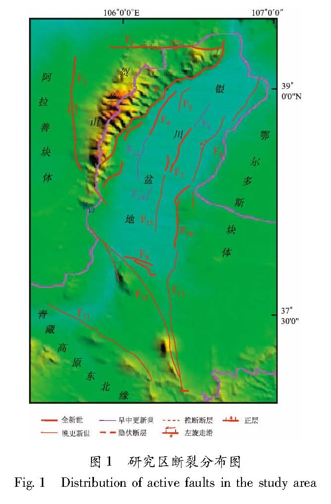
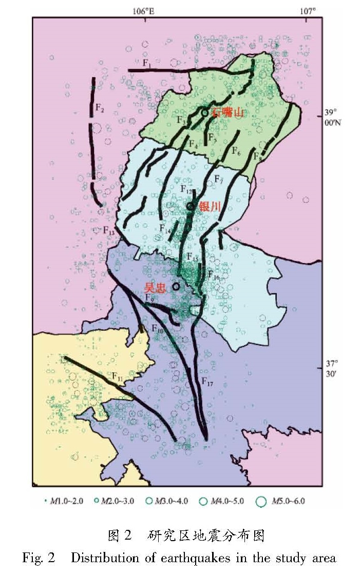
研究区位于宁夏回族自治区北部的银川盆地及其周边地区(105°31'~106°57'E,37°16'~39°18'N)。该区属于我国西部人口较多,经济发展速度较快的地区之一。银川地堑型盆地位于南北地震带北端,近年来,围绕银川和石嘴山两市活断裂探测以及沿黄河分布的陶乐规划区、精细化工基地活断裂探测等项目的开展,分别建立了各自的数据库,其成果为本文研究提供了基础,图1为研究区内分布的活动断裂,主要断裂及其活动性列于表1。区内历史地震多、强度高,自公元876年以来共发生过8级以上地震1次(银川—平罗8.0级地震),7级以上地震1次(银川7.2级地震),5.0~7.0级地震35次(柴炽章等,2011)。自1970年有仪器记录以来,共记录到1级以上地震3 359次(其中,1.0~1.9级1 317次,2.0~2.9级1 659次,3.0~3.9级324次,4.0~4.9级49次,5.0~5.9级10次)(图2)。
2 断裂缓冲区的创立
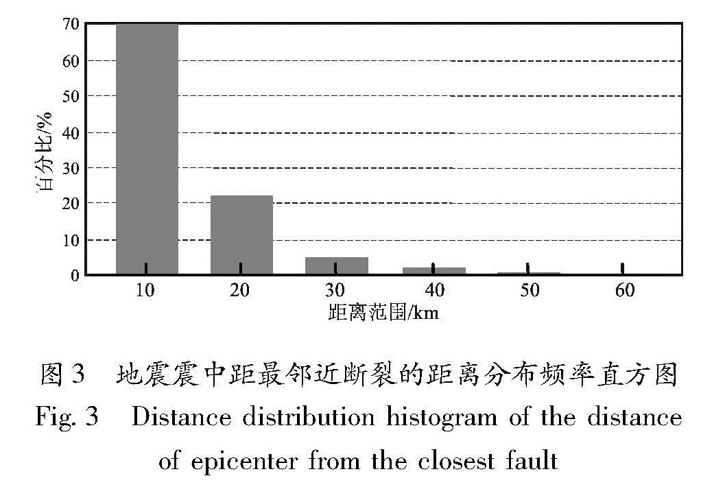
在GIS缓冲区分析中,缓冲区是指地理空间目标的一种影响范围或服务范围(袁怀月等,2011),可以分别以点、线、面为基本要素建立其缓冲区。以断裂为目标建立的缓冲区属于线要素缓冲区,线要素类缓冲区可以是双侧对称的、双侧不对称的或单侧的(董鹏等,2004)。本文研究采用双侧对称缓冲区。由于对缓冲区的半径(宽度)并无统一标准,本文使用反推统计的方法,统计离断裂最近的地震分布频率,将最高频率所对应的距离定为创立断裂缓冲区的最佳距离。
具体做法是选用区内仪器记录M≥1.0的地震,使用ArcGIS空间分析中的最邻近分析工具,计算震中最近断裂的距离,对所得结果按每隔10 km为一档进行分类,计算每个档次内的地震频率,据此绘制地震震中距最邻近断裂的距离分布频率直方图(图3)。从图3中可以看出在距断裂10 km范围内地震分布最多,约70%,距离断裂10~20 km范围内地震分布频率也达到了25%左右,两项合计约有95%的地震分布在距断裂两侧20 km范围内,据此分别建立半径为10 km和20 km缓冲区,作为探讨地震与活动断裂关系的依据。
3 地震与断裂的叠加分析
叠加分析是GIS技术中的一项非常重要的空间分析功能,是指在统一空间参考系统下,通过对两个数据进行的一种或多种集合运算,产生新数据或改变丰富原有信息的过程。这里提到的数据可以是图层对应的数据集,也可以是地物对象。叠加分析的目标是空间位置上有一定关联的空间对象的空间特征和专属属性之间的运算。多层数据的叠置分析,不仅产生新的空间关系,还会产生新的属性特征关系,能够发现多层数据间的相互联系、差异和变化等关系特征。此处使用点与多边形叠加,实际上是计算多边形对点的包含关系(李建松,2006)。
分别将围绕各断裂形成的半径为10 km和20 km的缓冲区面图层与震中点图层叠加形成新图层,统计在每个断裂缓冲区内的地震数目与断裂长度等属性信息并添加字段存储,计算单位长度断裂地震发生数,即单位长度地震频率,并比较不同活动时代、不同性质的断裂所对应的地震发生频率。
3.1 断裂带的地震活动性由地震与断裂缓冲区的叠加分析,计算得到单位长度断裂地震发生数。对以10 km为半径的缓冲区内,以等间隔分类法分为≤2、2.2~4.4、4.4~6.6、6.6~8.8共4个类别,如图4a所示。从图中可以看出,近代地震在银川地堑南部(银川至灵武、吴忠一带)最为密集。就活动断裂而言,黄河断裂南段(灵武东山西麓断裂)单位长度断裂地震发生数最高(图中蓝色标示),其次为银川断裂南段、永宁西断裂及关马湖断裂(图中玫红色标示),银川地堑南部以外的地区单位长度断裂地震发生数目都≤2(图中黄色标示)。图4b为以20 km为半径的缓冲区做相似分类的叠加分析结果,与图4a相比,除原有断裂缓冲区范围增大外,北西方向分布的贺兰山东麓断层和南部的烟洞山断层缓冲区由黄色变成了橙色范围,即单位地震数发生了较大变化。
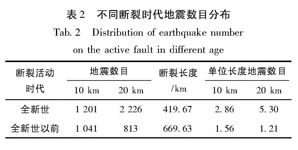
3.2 不同时代活动断裂与地震的关系研究区内活动断裂的活动时代分为全新世、晚更新世、早中更新世,全新世为距今10~12万年前。由于缓冲区内断裂分布密集致使断裂缓冲区有较多重叠且地震归属具有不完全确定性,故将落在全新世活动断裂缓冲区内的地震划归为该缓冲区内统计,在全新世以前的活动断裂缓冲区内不再进行重复统计。为说明全新世断裂的活动性,将断裂时代粗分为全新世和全新世以前,分别统计出断裂缓冲区内地震总数与断裂总长度,然后分别计算单位长度断裂对应的地震数,表2分别计算了全新世及全新世以前,半径为10 km和20 km缓冲区内地震数,并计算得到对应的单位长度地震数,半径为10 km缓冲区全新世地震数目约为全新世以前的1.8倍,半径为20 km缓冲区前者约为后者的4倍。表2中单位长度地震数说明全新世断裂的活动性较全新世以前强,与理论相符。
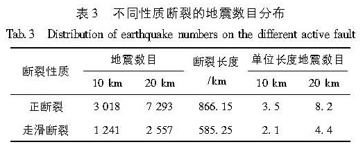
3.3 断裂性质与地震的关系为探讨该区域不同性质的断裂与地震间的关系。同样用断裂性质为检索分类字段,统计相同性质断裂缓冲区内的地震总数目和断裂累计长度,并求二者比值即单位长度对应地震数(表3)。研究区共计17条断裂,分为正断裂(11个)和走滑
图4 半径10 km(a)和20 km(b)缓冲区单位长度地震数目分类渲染图
Fig.4 Rendering of earthquake number classification per unite length in buffer of radio 10 km(a)and 20 km(b)断裂(6个)。从表4可以看出,正断裂单位长度地震数目明显高于走滑断裂,说明银川地堑近代处于拉张应力控制之下,就断裂的活动性而言,正断裂活动性较强。
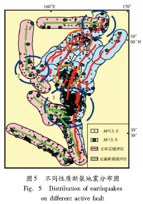
3.4 断裂与地震的空间关系为进一步探讨地震空间分布与断裂空间展布之间的关系,以10 km为半径的缓冲区为例,将研究区内的正断裂缓冲区以蓝色标示,走滑断裂缓冲区以粉色标示,并将1970年后仪器记录地震按震级划分为M>3以及M≤3两类,绘制成图5。从图中可以看出在断裂交汇区地震分布较密集,且M>3地震在断裂交汇区显示出更明显的集中。
其中1、2、3号区域(蓝色虚线圆圈区域)为平面上正断裂与走滑断裂交汇区,4、5号区域(橙色虚线圈区域)为正断裂交汇区。方盛明等(2009)研究表明,银川断层与贺兰山东麓断层在19~20 km深度交汇,芦花台断裂与贺兰山东麓断裂在12~12.25 km深处交汇。4 结论与讨论
(1)GIS技术为地震地质研究,特别是活动断裂与地震关系的研究,从描述性阶段过渡到定量化提供了一个有效的平台。
(2)银川盆地内中小地震与断裂关系的GIS研究结果证明,中小地震的发生也与活动断裂有密切关系。笔者认为,若在地震预报研究中能充分考虑地震地质条件,可能会取得更好的效果。
(3)数据统计结果表明,沿着全新世活动断裂发生的地震较多。因此,需加强活动断裂的探测与活动性鉴定,且在活动断裂研究中鉴定断裂是否为全新世活动断裂至关重要。
(4)银川地堑及其周边分布的活动断裂包含正断裂、走滑断裂,而沿正断裂发生的地震在数量上占优势,这说明近代银川地堑仍处在拉张应力控制之下。
(5)在银川地堑及周边地区,两组断裂在平面或剖面上交汇之处,易于发生地震。
宁夏地震局分析预报中心提供了地震目录,研究中利用了活断裂项目组的数据库资料,写作过程中得到孟广魁研究员的帮助,在此一并表示衷心的感谢。
- 柴炽章,孟广魁,马贵仁,等.2011.银川市活动断层探测与地震危险性评价[M].北京:科学出版社.
- 邓起东,张培震,冉勇康,等.2003.中国活动构造与地震活动[J].地学前缘,10(S1):66-73.
- 董鹏,毛东军,李军,等.2004.一种有效的GIS缓冲区生成算法[J].计算机工程与应用,(16):4-8.
- 方盛明,赵成彬,柴炽章,等.2009.银川断陷盆地地壳结构与构造的地震学证据[J].地球物理学报,52(7):1768-1775.
- 李建松.2006.地理信息系统原理[M].武汉:武汉大学出版社.
- 刘峰,张家声,黄雄南,等.2009.利用GIS方法研究南北地震带和中央造山带交汇区活动断裂与地震的关系[J].中国地震,25(4):394-404.
- 秦润君,吴虹,许浩,等.2012.基于ETM+遥感数据的闽南地区断裂活动性评价探讨[J].山东国土资源,28(5):17-20.
- 屈春燕,叶洪.2000.利用GIS分析活动断裂与地震的相关性[J].地震研究,23(1):72-75.
- 宋俊高,朱元清.2002.GIS技术应用于城市防震减灾工作[J].西北地震学报,24(1):85-91.
- 王金艳,马保起,秦志亮.2008.基GIS研究南黄海活动断裂与地震的关系[J].西北地震学报,30(4):400-404.
- 邬宁芬,周祖翼,劳秋元,等.2004.GIS支持下地震与活动断裂关系研究[J].大地构造与成矿学,28(3):248-253.
- 袁怀月,候澄宇,杨恒.2011.基于ArcGIS Flex API的工厂基础地理信息共享服务系统设计[J].测绘工程,20(2):61-65,69.
