3.1 InSAR形变场分析
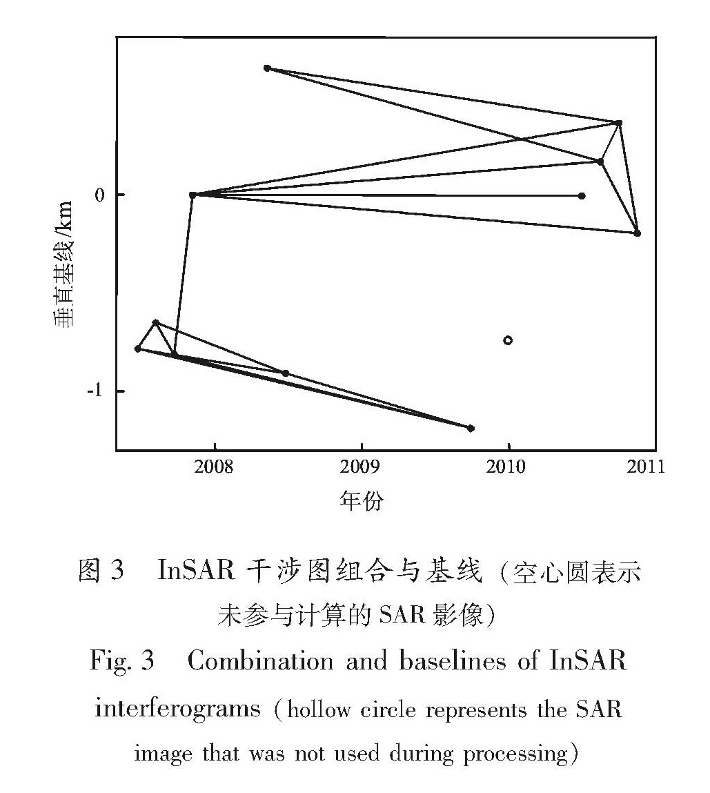
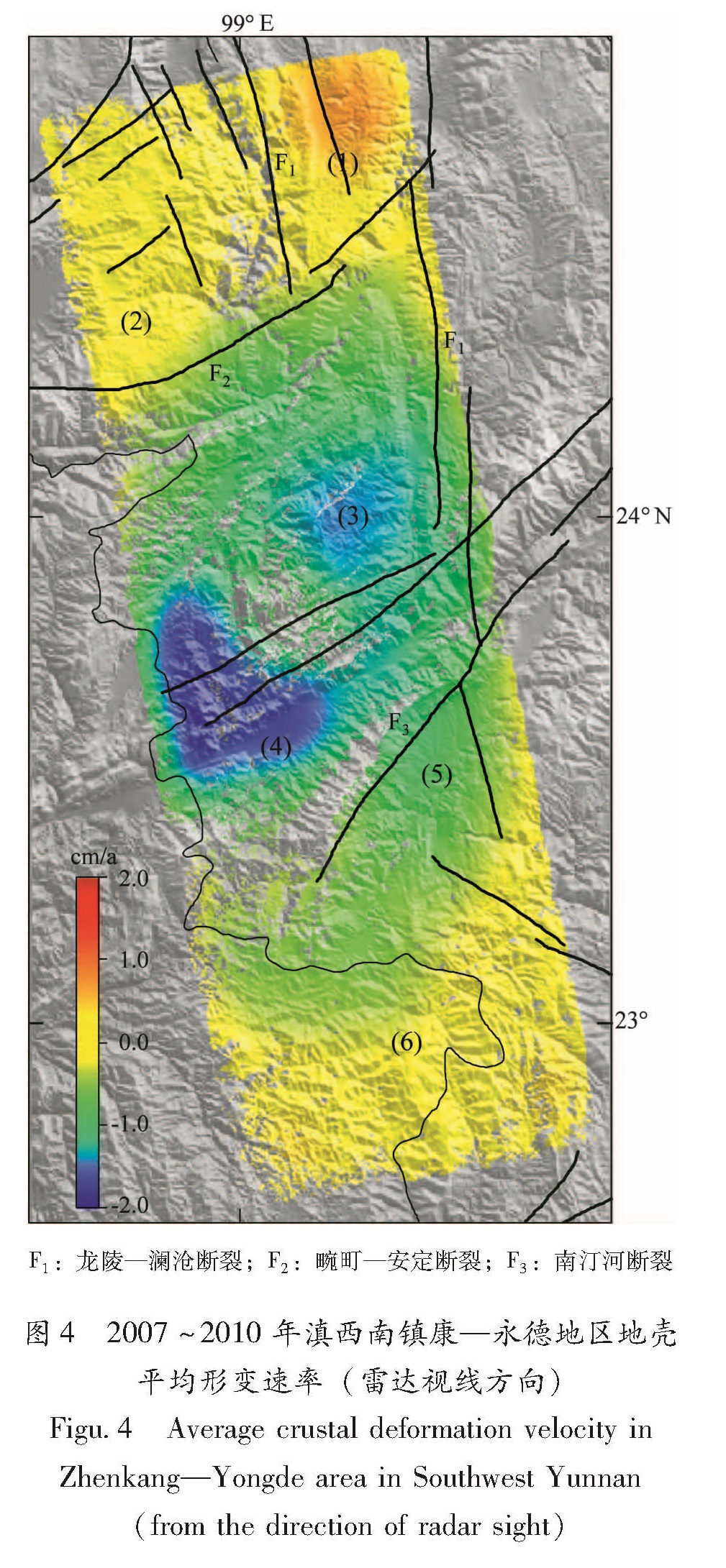
虽然ALOS PALSAR影像工作在L波段,允许较长的空间垂直基线,然而数据处理结果表明,由于研究区域地形起伏较大,垂直基线大于1 000 m,则会造成较严重的空间失相干。图3为选取进行干涉图堆叠计算的17幅干涉图的时间和空间基线信息,图中可见所有干涉图的垂直基线均较短,在800 m以内,保证了后续计算结果的可靠性。图4为通过干涉图堆叠技术得到2007~2010年镇康—永德地区的平均地壳形变速率(雷达视线方向),图中序号(1)~(6)为选取的指定区域,用于提取形变时间序列(图5)。由图4可知:(1)干涉图整体相干性较好,仅在部分地势陡峭的山区失相干;(2)形变异常位于区域中间部位的南汀河断裂带附近,为北东—南西方向的近椭圆形异常下沉区域,最大下沉形变速率近2 cm/a;(3)区域内分布的断层大多形变不明显,仅区域北部的畹町—安定断裂两侧存在差异性运
F1:龙陵—澜沧断裂; F2:畹町—安定断裂; F3:南汀河断裂
图4 2007~2010年滇西南镇康—永德地区地壳平均形变速率(雷达视线方向)
Fig.4 Average crustal deformation velocity in Zhenkang-Yongde area in Southwest Yunnan (from the direction of radar sight)
动,断层运动性质为左旋,差异运动速率约为5 mm/a(雷达视线方向)。地震地质研究结果表明,畹町—安定断裂第四纪以来活动性较强,其水平左旋滑动速率约为2~3 mm/a(常祖峰等,2012; 吴中海等,2012),与本文InSAR技术得到的结果比较吻合,并且该断裂参与了龙陵、瑞丽一带的地震活动(常祖峰等,2012),未来的强震危险性仍不能忽视(吴中海等,2012)。
为了揭示滇西南镇康—永德地区地壳形变随时间的演化特征,本文利用短基线集技术计算了2007~2010年滇西南镇康—永德地区形变时间序列。图5是选取的研究区域不同位置的形变时间序列曲线,2007~2010年间几处区域均表现出不同程度的形变波动特性,其中,(2)、(5)、(6)三处波动幅度较小,表明这3个区域相对比较稳定;(1)、(3)、(4)三处波动幅度较大,最大达9 cm,表明这3个区域可能存在不同程度的构造活动。
图5 选取指定区域的InSAR形变时间序列
Fig.5 InSAR deformation time series of the selected designated areas
3.2 InSAR形变场可靠性分析
首先,在获取地壳形变场的技术方法选取上,本文采用干涉图堆叠和短基线集两种技术,较多研究实例表明,这两种技术可以以较高的精度提取区域的微小地壳形变,被证明是可靠的(Emardson et al.,2003; Biggs et al.,2007); 其次,InSAR监测结果显示,2007~2010年滇西南的镇康—永德一带地壳形变波动较大(图5),该区域2011~2013年的水准监测结果也表现出较强的波动特征。虽然两者的监测时间不一致,无法直接进行定量比较,但是从运动趋势来看,两者均显示相似的波动特征,表明InSAR监测结果是可信的。
3.3 结果对比分析与讨论
为了探讨和分析滇西南镇康—永德一带的区域地壳运动状态和地震危险性,本文收集了2009~2013年研究区域的GPS水平速度场,如图6所示。为了便于分析比较,图6同时叠加了20世纪70年代至2011年的长期地壳垂直运动速率(郝明,2012)以及本文干涉图堆叠技术获得的2007~2010年研究区的平均地壳形变速率。GPS水平速度场表明,相对于欧亚板块,镇康—永德一带整体向南运动,量级约5~6 mm/a,2011~2013年相对于2009~2011年有整体向西旋转运动的趋势,幅度不大。区域内部水平形变差异不显著。在数十年时间尺度上,相对于北部的昌宁地区,镇康—永德一带表现为大幅垂向隆升,量级约为2~3 mm/a。可见,水准资料显示的地壳形变隆起区与InSAR反映的地壳形变下沉区范围基本一致,分析两者反映相反的形变态势,可能有两个原因:(1)区域地壳垂直运动在数十年的时间尺度上较为稳定,但在几年至数年时间尺度上则往往波动较大(王庆良等,2008)。郝明(2012)获取的垂直运动速率反映的是近40年时间尺度的平均速率,是区域长期稳定地壳垂直运动的体现。而本文的InSAR资料时间跨度仅为3.5 a,反映的是区域近期的地壳运动状况,可能说明区域近期地壳运动有活跃增强的趋势。因此,两种手段反映的是不同时间尺度范围的地壳运动状况。(2)InSAR形变场是区域各个方向地壳运动分量在雷达视线方向的投影(主要反映的是区域垂向运动特征),而水准测量结果仅是垂直方向的运动。因此,两者反映的区域地壳运动方向不同。综合分析不同时间段的GPS、水准和InSAR地壳形变场,滇西南的
图6 研究区域不同时段GPS、水准、InSAR形变场
Fig.6 Deformation field from GPS,leveling and InSAR in the study area in different time periods
镇康—永德一带内部近期水平地壳运动不显著,以垂直形变为主,且近些年来地壳垂直运动比较活跃。值得注意的是,镇康—永德一带的地壳形变异常活动区内中强以上地震活动较弱,从
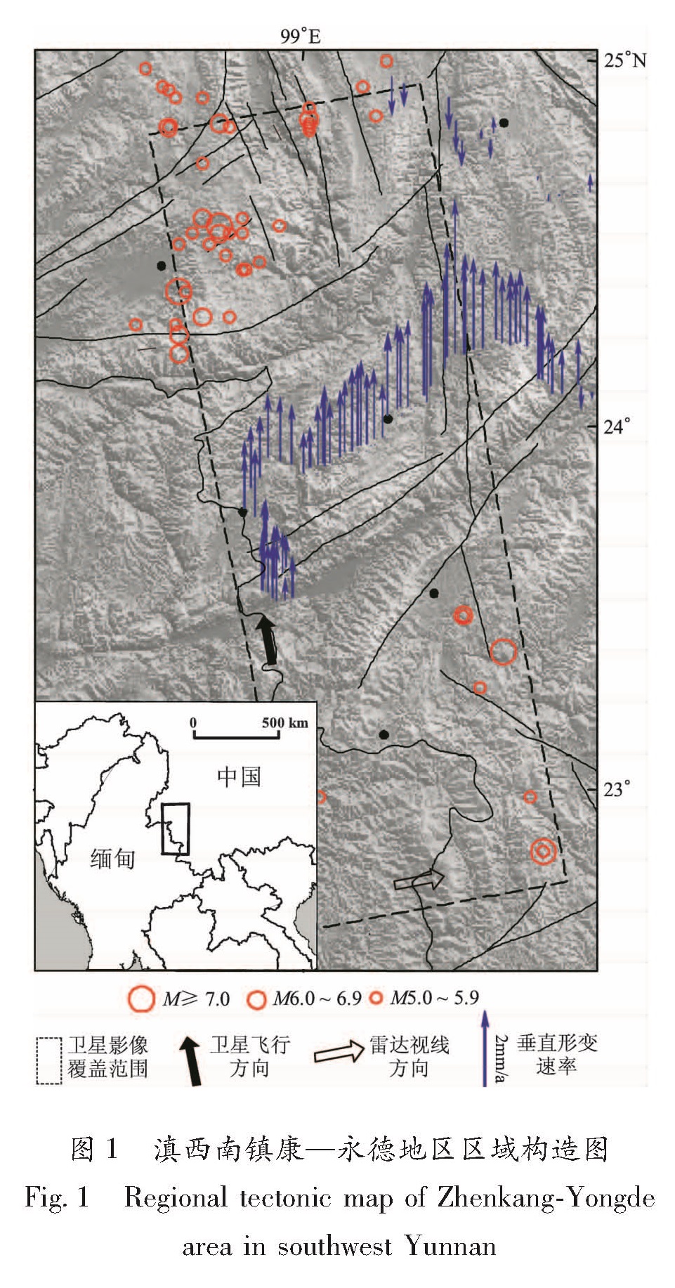
图1可以看出,1970~2013年的四十余年间该区域缺乏5级以上地震活动,因此未来发生中强以上地震的危险性不容忽视。