3.1 评价单元划分
目前,广为被大家所接受的预测单元主要包括:栅格单元、地域单元、斜坡单元、子流域单元和均一条件单元(刘斌,2009)。评价单元的划分主要依靠比例尺的大小和空间数据的精度高低,如比例尺小于1:5万及等高线数据在10 m以上的空间数据,易采用规则的栅格单元作为评价的基本单元。本文研究区为整个汶川县域,总面积为4 086 km2,县域东西宽84 km,南北长105 km,单个的斜坡单元已经超出了全图图幅所能清晰表达的能力范围,除特大型滑坡外,滑坡体的面状形态几乎可以用点来代替,在这种情况下,使用栅格数据单元即可满足评价的精度(刘斌,2009; 王佳佳等,2014)。另外,在大数据量的前提下,栅格数据有其明显的运算速度快的优势。因此,本文选取栅格单元作为地震诱发滑坡敏感性评价的基础单元,并用点状滑坡数据代替面状滑坡数据,且点位于滑坡的源区。根据所获得的数据及国家数据库的行业标准,本文选取10 m×10 m做基础单元大小,对所获取的数据及在其基础上分析所得数据进行栅格化。研究区栅格划分为8 499列,10 535行,共计4 086万个栅格单元。
3.2 指标因素的选取及分级
控制和影响滑坡敏感性的因素有很多,包括地形地貌、水文条件、地质构造、气候、地层岩性、地震烈度和人类活动等(Parise,Jibson,2000; Tang et al,2009; García-Rodríguez et al,2008; Kamp et al,2008; 陶舒等,2010; 朱良峰等,2004; 许湘华,2010)。Tang等(2009)选用了坡度、高程、岩性、距断裂距离和水系共5个因子对汶川地震影响区进行了同震滑坡敏感性评价; 许冲等(2010)选用了地震烈度、岩性、坡度、距断裂距离、高程、坡向、水系与公路共8个因子对汶川震区进行地震滑坡易发性评价。为了突出影响滑坡敏感性的主要指标,笔者根据国内外较为普遍使用的评价指标和专家的意见,参考了前人研究成果(黄润秋等,2008a,b,2009b; 张永双等,2008; 殷跃平,2009; 许强,李为乐,2010; 许冲等,2010; Tang et al,2011),并结合本文研究区域的实际情况和GIS空间分析工具进行评价所需求的指标容量、可视化、可行性和可靠性,重点选取了地震烈度、断裂带、水系、高程、坡度和岩性共6个因素作为评价指标,并对每个指标进行分级。
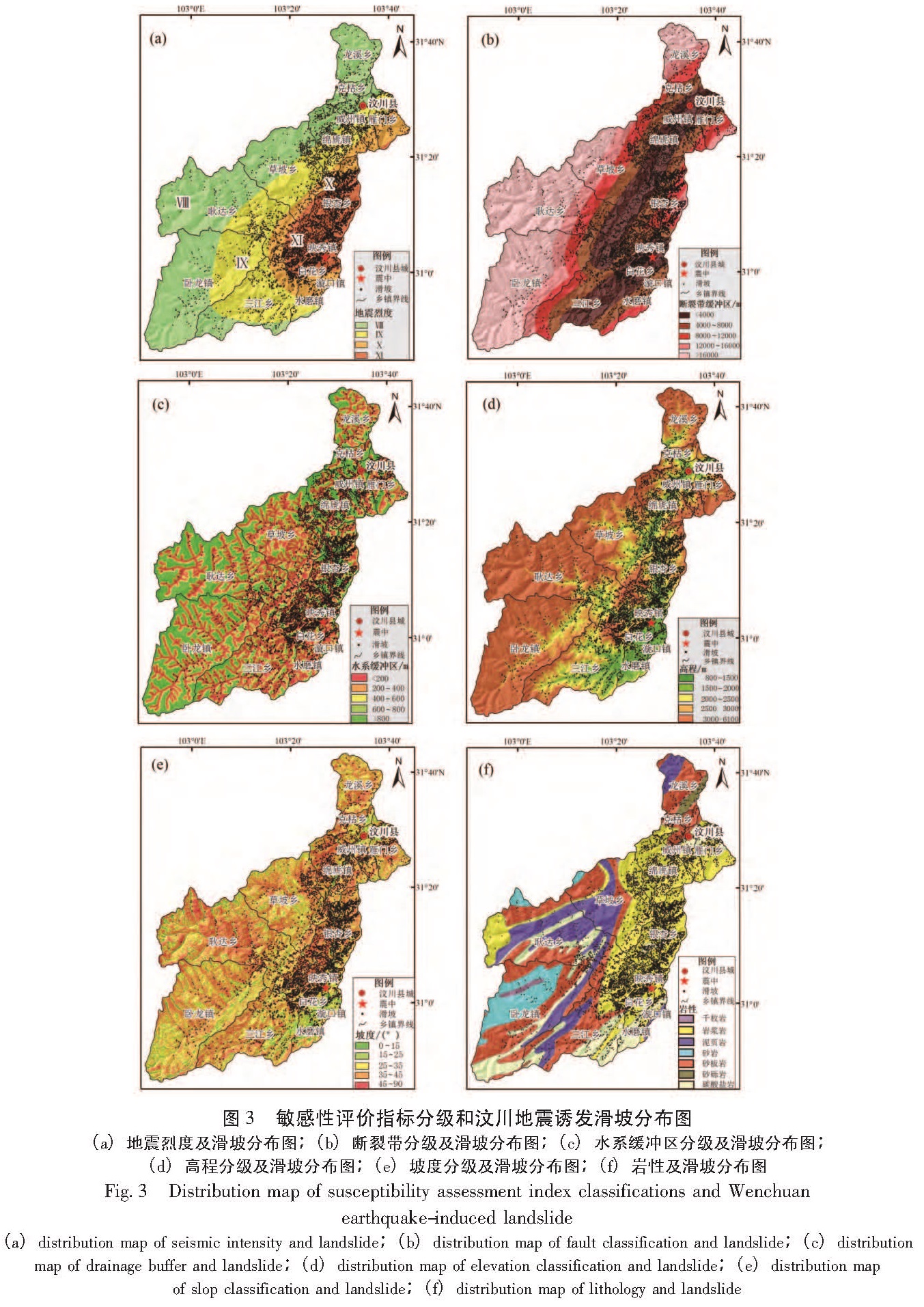
(1)地震烈度:地震烈度是指地震发生时某一地区的地面震动的强弱程度。地震烈度是影响地震滑坡的重要因素。以往的调查研究成果表明(唐川,朱静,2001),地震烈度等级与地震滑坡频次呈正相关,即在地震烈度等级高的地区,其滑坡出现的频次也就越高。由四川省地震局的地震烈度数据可知,在汶川县境内共有4个地震烈度带,分别为:Ⅷ、Ⅸ、Ⅹ和Ⅺ(图3a)。
(2)断裂带:地震滑坡的总体空间分布特征主要受断裂带的控制。距离断裂带越近,地质灾害越发育; 距断裂带越远,其地质灾害分布密度越小(黄润秋,李为乐,2009a)。断裂带数据从1:10万地质图中获得,汶川县境内共有两条大的断裂,分别为:茂汶断裂和映秀—北川断裂,断裂两侧多为地震诱发地质灾害发育区。利用ArcGIS软件、以断裂带为中心进行缓冲区分析,共划分为5个区域,分别为:0~4 000 m、4 000~8 000 m、8 000~12 000 m、12 000~16 000 m和>16 000 m(图3b)。
(3)水系:汶川县境内主要的河流有岷江和渔子溪。历史地震资料表明,水系的切割为滑坡的发生提供了临空面,滑坡分布与距水系的距离有着极其密切的联系。由调查成果可发现,强震区的滑坡多沿河流两岸分布,且距离水系越远,滑坡分布密度越小(许冲等,2010)。因此,水系对地震滑坡的发育具有很大的控制作用。水系数据来源于1:5万地形图。利用ArcGIS软件以水系为中心进行缓冲区分析,共划分为5个区域,分别为:0~200 m、200~400 m、400~600 m、600~800 m和>800 m(图3c)。
(4)高程:高程是地形因素的主要代表,其对滑坡的发育具有一定的影响(许冲等,2010)。在汶川县内,以高—中山地形为主,最低高程为800 m,位于汶川县东南部,最高高程为6 100 m,位于汶川县西部。高程低于2 000 m的区域占全县的18.5%。地形起伏较大,多为底部陡峭峡谷向平缓的宽谷过渡地带,仅沿河流两岸分布了少量的平坦地貌,应力相对集中。由1:5万地形图中的等高线数据生成数字高程模型(DEM),根据DEM,划分为5类,分别为:800~1 500 m、1 500~2 000 m、2 000~2 500 m、2 500~3 000 m和>3 000m(图3d)。
(5)坡度:坡度是地形表面的重要量化特征。坡度是影响斜坡体稳定的重要因素,坡度的大小在几何特征上就决定了地震滑坡的分布。普遍认为,在同等条件下,坡度越大越容易发生滑坡(Tang et al,2011)。因此,坡度被公认为是影响地质灾害分布的重要因素之一。汶川县境内64.4%区域的坡度为25°~45°。坡度数据从DEM中提取得到,并把坡度划分为5类,分别为:0°~15°、15°~25°、25°~35°、35°~45°和>45°(图3e)。
(6)岩性:岩土体类型及其结构对斜坡变形及其稳定性有着很大的影响,岩石的类型决定了岩土体的抗风化强度及力学特性。因此,滑坡分布与岩石类型有密切的关系(许冲等,2010; Tang et al,2011)。由1:10万地质图获得的岩性数据可知,本研究区共有7种岩石类型,分别为:砂板岩、岩浆岩、碳酸岩、泥页岩、砂岩、砂砾岩和千枚岩(图3f)。
3.3 指标敏感性分级量化
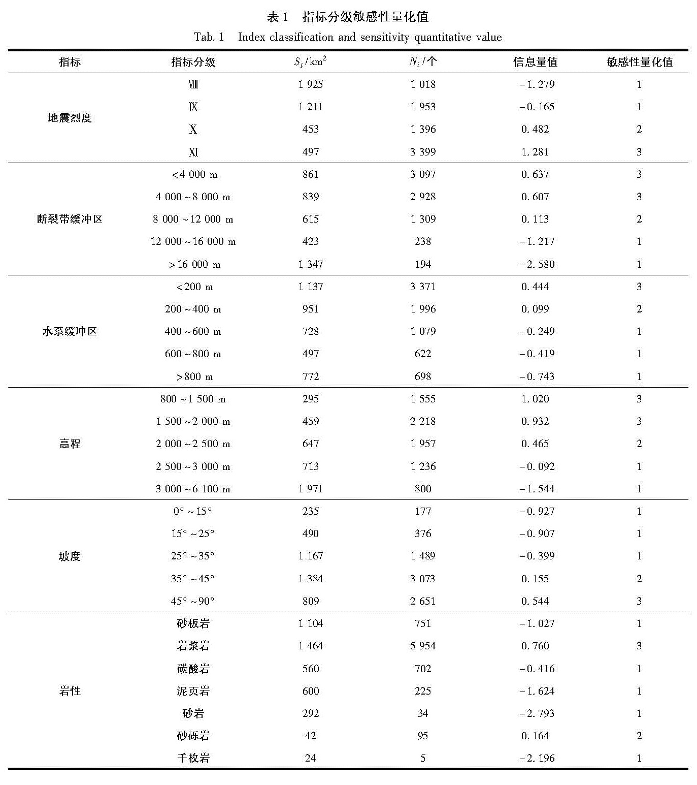
如何对指标量化是个很重要的问题,因为量化结果的好坏直接关系到评价结果的可靠性。量化的方法也是多种多样,其中传统的数学统计量化方法有其强大的优势,被国内外学者所接受。本文就是采用信息量法,利用ArcGIS软件,将栅格化的数据,按照上述分级要求进行重分类,结合地震诱发滑坡数据库进行统计,并将分级统计数据代入式(1),得到各指标各级别的信息量值(Kamp et al,2008),并根据指标内各级别信息量值的大小及差值进行指标内各级别间敏感性分级。指标内各级别敏感性分级量化值分别为1、2和3,分别代表着相对低敏感性、相对中敏感性和相对高敏感性(Tang et al,2009,2011)(表1)。
I(Xi,H)=ln(Ni/N)/(Si/S).(1)
式中,N为研究区域内地震诱发滑坡分布的单元总数; S为研究区域内评价单元总数; Ni为分布在指标xi内特定类别内的地质灾害单元数; Si为研究区域内含有评价指标xi的单元数。
表1数据表明:地震诱发滑坡的空间分布与水系和地震烈度有着很大的关系,地震诱发滑坡主要分布于地震烈度为Ⅺ的地区,地震烈度越大滑坡越发育; 地震诱发滑坡主要分布在距离断裂带两
图3 敏感性评价指标分级和汶川地震诱发滑坡分布图
(a)地震烈度及滑坡分布图;(b)断裂带分级及滑坡分布图;(c)水系缓冲区分级及滑坡分布图;
(d)高程分级及滑坡分布图;(e)坡度分级及滑坡分布图;(f)岩性及滑坡分布图
Fig.3 Distribution map of susceptibility assessment index classifications and Wenchuan earthquake-induced landslide(a)distribution map of seismic intensity and landslide;(b)distribution map of fault classification and landslide;(c)distribution map of drainage buffer and landslide;(d)distribution map of elevation classification and landslide;(e)distribution map of slop classification and landslide;(f)distribution map of lithology and landslide
表1 指标分级敏感性量化值
Tab.1 Index classification and sensitivity quantitative value
侧8 000 m范围内,在距断裂带8 000 m以外,其分布明显减少; 对于水系指标而言,敏感度随距水系距离的增大而减小,并对地震诱发滑坡分布起着绝对的控制作用,其原因主要是河流的切割作用形成的临空面为滑坡的发生提供了有力的地形条件,这说明地震滑坡空间分布特征有着明显的距离效应。另外,滑坡多分布在高程小于2 000 m的范围内,这可能是因为汶川县处于龙门山地区,高程低于2 000 m的地区多为河谷两侧,多为从陡峭峡谷向平缓宽谷的过渡带,且应力相对集中; 坡度在大于45°的范围内敏感度最大,说明斜坡越陡,发生滑坡的可能性越大。
3.4 指标敏感性权重
本文采用层次分析法(AHP)得到每个指标的地震诱发滑坡敏感性权重值。层次分析法的核心是构建判断矩阵。本文共选取了6个指标,通过向专家发放调查问卷对指标因子进行打分,并结合汶川地震以来的调查经验及成果,最终建立了指标权重判断矩阵。然后利用Matlab软件求得判断矩阵的最大特征值为λmax=6.023 0,一次性指标CI=(λmax-n)/(n-1)=(6.023 0-6)/(6-1)=0.004 6,通过查平均随机一致性指标(RI)表,可得RI(n=6)=1.26,则检验性指标CR=CR=CI/RI=0.0046/1.26=0.0037<0.1。该矩阵具有较好的判断一致性,即判断合理。其最大特征值λmax对应的特征向量为(0.228 9 0.106 9 0.055 0 0.273 5 0.106 9 0.228 9),对特征向量进行归一化处理,即可得到6个评价指标的权重,结果见表2。
表2表明:坡度、岩性、高程、水系、断裂带和地震烈度分别对应的权重为0.228 9,0.106 9,0.055 0,0.273 5,0.106 9和0.228 9。
表2 指标判断矩阵及权重
Tab.2 Comparative index judgment matrix and the corresponding weights
3.5 敏感性评价模型
结合表1和表2,可得到每个指标的分级敏感性量化值及其敏感性权重,故可构建加权线性评价模型:
LSI=AiXij.(2)
式中,LSI为滑坡敏感性指数(Landslide Susceptibility Index),Ai为指标i影响地震诱发滑坡敏感性权重,Xij为指标i的某一类别j的敏感性量化值。
则计算模型可以表达为
LSI=0.228 9X1+0.106 9X2+0.055X3+
0.273 5X4+0.106 9X5+0.228 9X6(3)
式中,X1、X2、X3、X4、X5和X6分别代表坡度、岩性、高程、水系、断裂带和地震烈度的指标量化值。
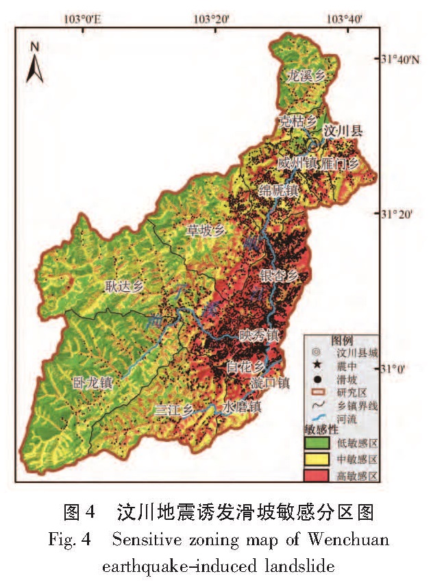
利用上述模型和ArcGIS空间分析功能进行加权叠加分析,最终得到LSI,LSI代表滑坡发生的相对敏感性。因此,指数越高,发生滑坡的可能性越大。然后再对整个汶川县进行敏感性区划,利用GIS技术中的栅格重分类工具,采用自然间距分类方法(Natural Breaks)将滑坡发生相对敏感性栅格图分为高敏感区、中敏感区和低敏感区(许冲等,2010; Tang et al,2009,2011)。自然间距分类方法的原理是使类别之间的差异最大化,使类别内部的差异最小化,是一种较客观的分类法,保持了类别之间的差异性和类别内部的一致性(许冲等,2010)。在汶川地震诱发滑坡敏感区划图的基础上,结合汶川地震诱发滑坡数据库,最终得到汶川县地震诱发滑坡在各敏感区分布图(图4)。
图4 汶川地震诱发滑坡敏感分区图
Fig.4 Sensitive zoning map of Wenchuan earthquake-induced landslide
3.6 敏感性评价结果分析
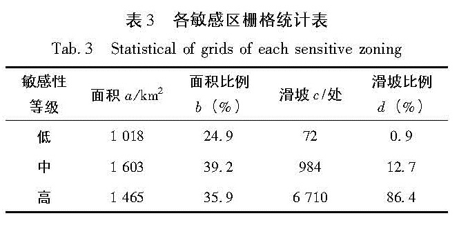
根据汶川县地震诱发滑坡的敏感性评价分区结果及汶川地震诱发滑坡数据库,统计各个敏感区的栅格数、总栅格数、各个敏感区占总区域的比例、滑坡总数、各个敏感区的滑坡个数和各个敏感区的滑坡个数占总滑坡的比例,详细数据见表3。
从图4和表3可知:研究区域的总面积为4 086 km2,由汶川地震诱发的滑坡共7 766处。其中高敏感区1 465 km2,地质灾害点6 710个,35.9%的面积分布了86.4%的滑坡; 中敏感区
表3 各敏感区栅格统计表
Tab.3 Statistical of grids of each sensitive zoning
1 603 km2,地质灾害点984个; 低敏感区1 018 km2,地质灾害点72个,占滑坡总数的0.9%。低敏感区主要分布在汶川县西部,多为高山地区。高敏感区主要分布在汶川县中东部,特别是映秀镇及其周边地区。另外高敏感区主要分布在岷江及渔子溪沿岸,可见水系对地震诱滑坡发布起着绝对控制作用。地震烈度对地震诱发滑坡分布起着重要的影响,烈度Ⅺ的区域大部分为高敏感区; 岩体作为地震波的传播介质,对其分布也有一定的影响,高敏感区的岩性多为岩浆岩。由图4和表3分析可知,在高敏感区发生的滑坡最多,其滑坡发生的比例也最大。从在各个敏感区发生滑坡的比例可看出,敏感区由高到低,其发生的滑坡比例及滑坡发生的比例也由高到低,在理论上符合敏感性等级划分的原则。而且高敏感区占总面积的35.9%,其滑坡数占总滑坡数的86.4%,与实际情况相符。总之,本文的地震诱发滑坡敏感性评价具有较高的成功率,基本达到了之前的预期要求。
4 结论与讨论
以汶川县为研究区,利用高分辨率遥感影像进行精细解译,建立了地震诱发滑坡空间属性数据库,选取地震烈度、断裂带、水系、高程、坡度和岩性共6个指标建立敏感性评价体系,在GIS技术支持下,利用层次分析法和信息量法相结合进行区域地震诱发滑坡敏感性评价,结果表明汶川地震诱发滑坡敏感性分区图符合研究区的实际情况,且精度较高,能够给滑坡风险管理和项目建设选址提供一定的帮助,也可为下一步的危险性评价和风险性评价做准备。
从汶川地震诱发滑坡的敏感性评价结果来看,低敏感区占全县的24.9%,主要分布在汶川县西部,且多为高海拔地区。高敏感区占了35.9%,主要分布在映秀镇及周边地区,也体现出了岷江及渔子溪沿岸为高敏感区的特点,说明水系对滑坡发生起着绝对的控制作用。同时,也可以发现地震烈度越大、距断裂带水系越近和坡度较陡的区域越有利于地震次生灾害的发生。