地貌特征是地质构造格局的基本反映,是新构造运动过程中必然的分布规律(李祥根,2003)。宏观地貌发育的总体特征代表了长周期、大尺度区域构造作用的结果,记录了不同变形过程(张会平等,2012)。目前,常用的地貌发育特征因子包括地形起伏度和坡度等。
3.1 总体地势特征
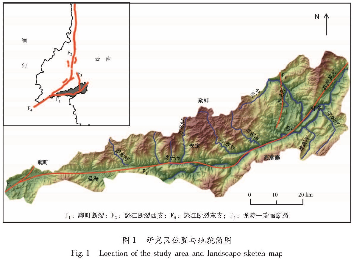
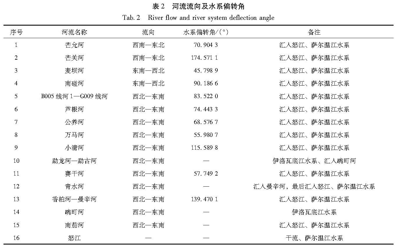
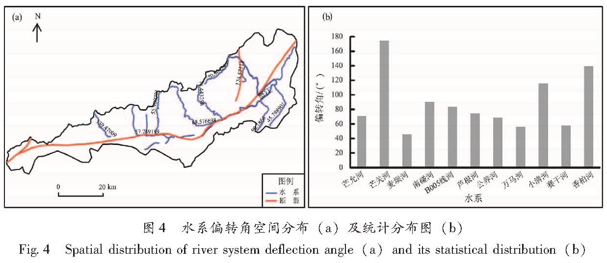
整体上,研究区呈现出东北高而陡峭、西南低而宽缓的地势特征,该区属于高黎贡山以西的一块自东北向西南倾斜的切割山原。从数值特征看,研究区高程值介于517~2 917 m,呈三级夷平面分布形态,各级分布形态总体受区内主干断裂控制,东北部以高黎贡山为主体,夷平面呈东北至西南的弧形展布。整个研究区内水系发达,涉及到的水系主要隶属于伊洛瓦底江水系和萨尔温江水系。海拔在517~1 258 m的区域,为水系、盆地及少量特征不明显的一级阶地,约占研究区总面积的38.12%; 海拔在1 258~1 848 m的区域,多为二级阶地,约占研究区总面积的39.55%; 海拔为1 848~2 917 m的地区主要分布在研究区的北东向和正南,约占研究区总面积的22.33%,并以这一海拔相对高的地区作为流域分水岭界面向西南递降,在分水岭地带抬升的同时,畹町断裂局部相对下降,形成串珠状分布的断陷谷和断陷盆地。研究区内山水对照明显的地貌,以及与区域抬升相对出现的“线状”分布断陷带,是以畹町断裂为主体的构造带新生代以来产生强烈的垂直差异运动的结果。
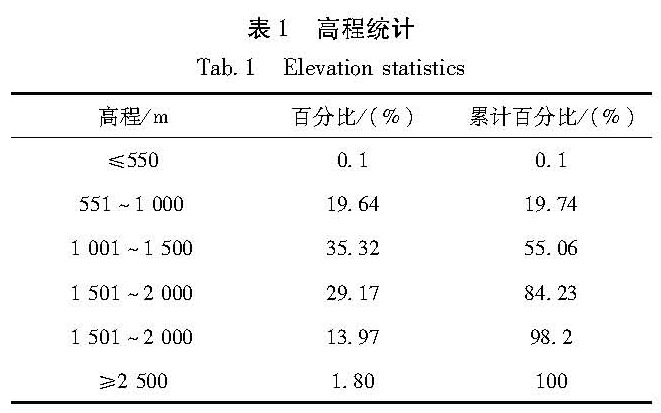
通过高程值分布统计(表1)可以看出,流域内海拔高度主体集中在1 000~1 500 m,约占整个研究区总面积的35.32%。畹町断裂两侧的地势地貌特征差异明显。流域内北部海拔高而地势平缓,沿断裂两侧表现出一条清晰的地势陡变带,垂直断裂线方向断裂两侧海拔高程最高处接近(图2)。断裂对研究区地势地貌的控制作用还具体表征为高程值随距离断裂远近有明显的相关关系,总体特征表现为沿断层垂直方向随距离的增加高程快速增加,当高程增加到1 500~2 000 m时,则不因距离的变化而发生明显变化。从在断层两侧的高程总体数值分布看,断层西北侧山地高程比东南侧山地高程相对较高,分析其原因,一种可能的模式是西北盘受到源自印度板块挤压力量,沿断层面较东南盘抬升; 另一种可能是研究区在受后期流水侵蚀过程中遭遇剥蚀程度的差异。这样的情况综合反映了断裂两侧垂直运动和遭受剥蚀的差异,也是被断裂分割的西北侧抬升作用明显的表现。
表1 高程统计
Tab.1 Elevation statistics
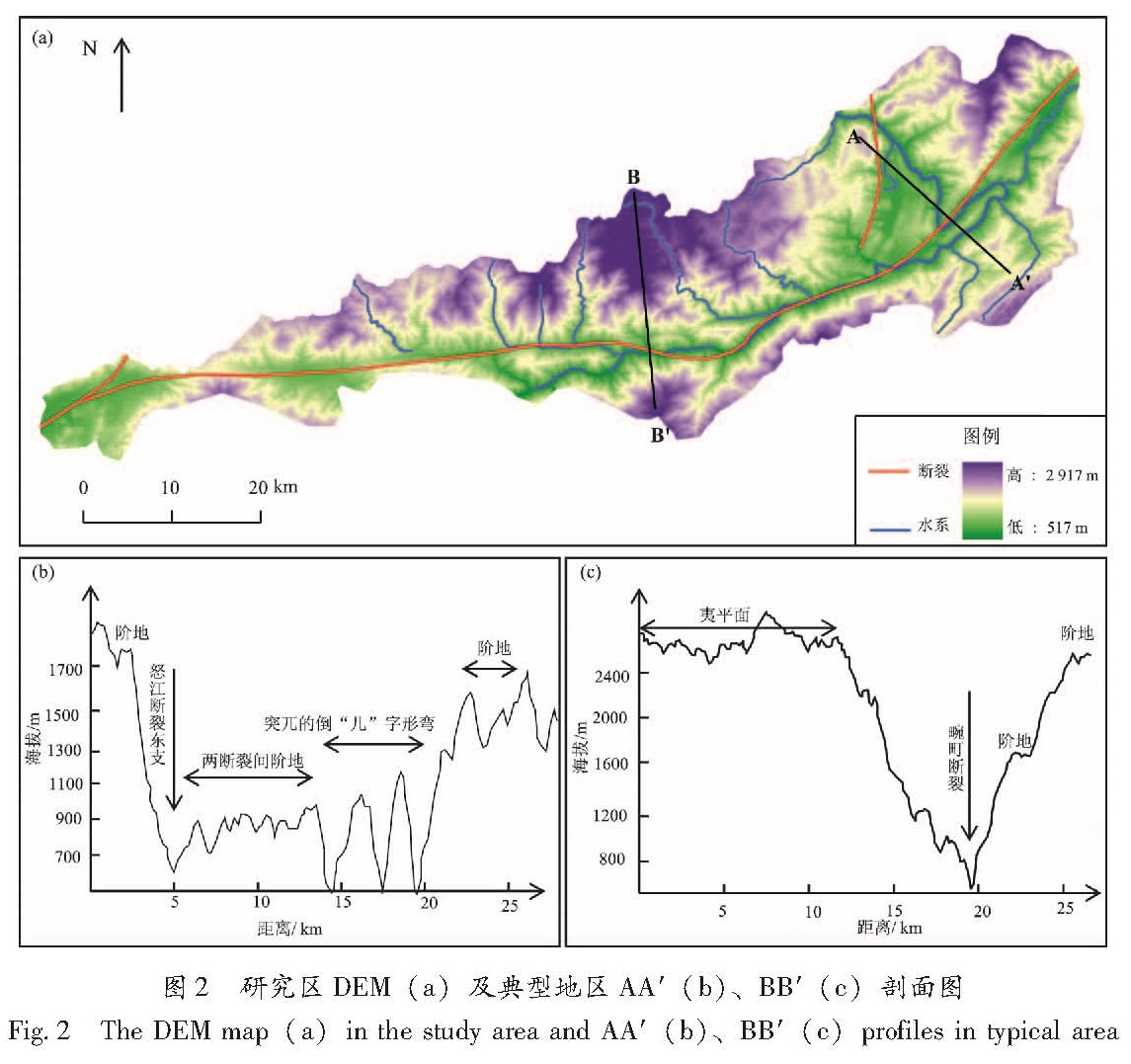
为了进一步认识断层两侧地势地貌的特征,分别选取两组断裂2侧典型位置AA'和BB'(图2a)进行地形剖面分析,其中AA'位于怒江与畹町断裂交汇的拐弯处; BB'位于安定附近,为万马河与怒江干流的汇水点附近(历史上曾发生过MS6.0地震)。剖面AA'(图2b)反映了怒江断裂东支与畹町断裂之间地势起伏状况和地貌类型。怒江断裂东支左盘有阶地发育,阶地的高程主要集中在1 700 m左右,怒江断裂东支与畹町断裂之间区域为怒江沿岸的阶地,高程集中在900 m左右。怒江与畹町断裂交汇处呈现突兀的“几”字形拐弯,在纵剖面上可以看出,短距离内高程差达400~500 m; 畹町断裂东北盘蚌冬一带为阶地,高程集中在1 500~1 600 m。剖面BB'(图2)反映了研究区域内从正北(高程最高)向南(跨断裂)的地势起伏状况和地貌类型。畹町断裂西北盘高程主要集中在2 400 m以上,应为古高原夷平面,推测可能由于地层岩石坚硬,抗后期侵蚀能力较强,因此地形高而平缓; 跨畹町断裂带两侧,纵剖面起伏呈近垂线下降。BB'反映的另外一个地势地貌特征是其南北两侧存在差异,顺断层发育的河谷北侧阶地不发育,而南侧阶地相对发育,在海拔1 600 m和2 400 m左右的地带都有分布。剖面AA'和BB'显示了相同的地势地貌特征,从两侧向河谷地貌单元由山地(大多山地为古高原面受后期雨水侵蚀形成)、阶地、盆地(河漫滩)、河谷逐渐过渡。从断裂两侧地形起伏看,地形起伏大的地区与山系吻合,从断裂经过的盆地边缘向外开始地形起伏主体多达1 km; 地形起伏小的地区主要紧邻断裂的河漫滩(盆地)和断续分布的一级阶地接阶地,起伏则大多小于500 m。剖面AA'和BB'反映的另外一个特征是阶地地貌特征不明显,上一级阶地和下一级阶地之间地势陡峭,海拔高程大多呈近垂直向下降。与经典的侵蚀阶地相比,我们认为畹町断裂带分布的阶地不是因为构造抬升河水流速加大、侵蚀加强,河流下切形成; 而是因为构造运动造成河流被动沿构造带断裂面迅速下切形成,换言之,畹町断裂在很大程度上控制了区域河流阶地的发育及其形态特征。
图2 研究区DEM(a)及典型地区AA'(b)、BB'(c)剖面图
Fig.2 The DEM map(a)in the study area and AA'(b)、BB'(c)profiles in typical area
3.2 地形起伏度
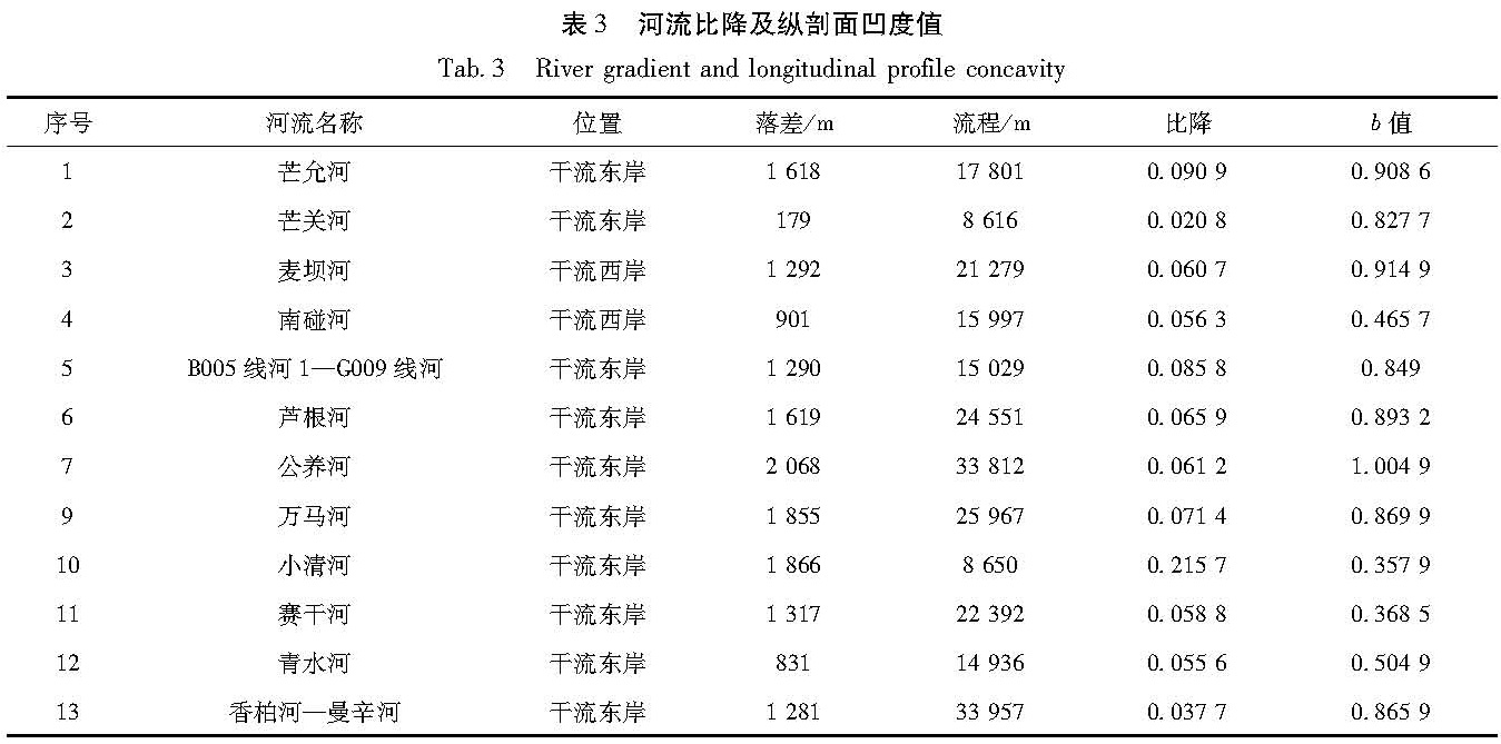
一个区域的地形起伏是构造作用与地表剥蚀过程相互作用的结果(梁明剑等,2014; 张会平等,2012)。地形起伏度是指在一定区域范围内,最大高程值和最小高程值之间的差值,通常用于描述一个区域地形起伏的宏观性特征,也反映区域地表的切割剥蚀程度。地形起伏度也是进行区域内地貌对比和地貌类型划分的客观依据(程维明等,2009),在某种意义上反映地貌的发育阶段,年轻的地貌多有较大的起伏度,年老的地貌经受了夷平作用,地势起伏度较小。
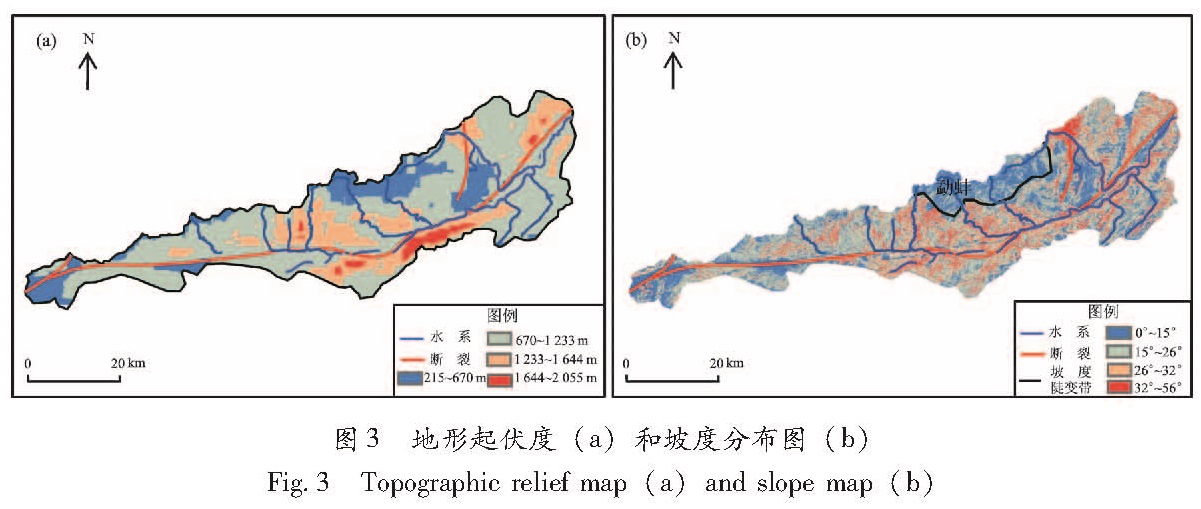
地形起伏度存在明显尺度依赖特征,Focal函数较Block函数更能显著提高地形起伏度计算精度(张磊,2009)。徐汉明和刘振东(1991)通过对全国 600 个样点和2个小区的详细研究,运用模糊数学方法,得到并论证了中国地势起伏度最佳统计单元为 21 km2。本研究使用空间分辨率为30 m 的DEM数据,参照徐汉明和刘振东(1991)的方法,计算地形起伏度,采用的窗口大小为 150 个栅格单元的矩形窗口,面积约为 20.25 km2,最接近21 km2。计算时选用Arcgis中空间分析邻域计算下Focal函数对DEM栅格数据的最大高程和最小高程进行差值运算,得到区域地形起伏的定量化计算结果,然后再对地形起伏度进行再分级成图(图3a)。
研究区地形起伏度计算结果(图3a)表明,研究区地形起伏度介于215~2 055 m之间。空间分布整体趋势为东北部大于西南部。地形起伏高值主要分布在怒江干流与畹町断裂的高度重合区域,公养河—高家寨一带的地形起伏度具有明显的高值分布特征,垂直地貌特征表明畹町断裂东南盘从公养河—高家寨一带断层地貌较为典型,结合极高值区呈斑块状分布特点,可以较好地解释从公养河—高家寨一带有广泛的断层槽地、断层陡崖、断层三角面等典型断层地貌分布的现象。地形起伏度在上述区域高值分布的特征一方面表明畹町断裂有明显活动痕迹,另一方面则反映了在断裂历史活动过程中,该区域可能是较为主要的应力作用集中区域,西北盘对东南盘的作用力极有可能为WWN—EES方向。
3.3 坡度格局
在地貌分析中,坡度值定义为坡面的铅直高度与水平距离之间的比值,相对应地,坡面与水平面之间的夹角成为坡度。坡度可以通过统计计算每一个像元与其周围像元之间高程差和水平距离比值的最大值获得,相应的计算结果也有2种表达形式,即坡度和坡度百分比(张会平等,2010)。本研究坡度的计算结果以坡度形式显示(图3b)。
图3 地形起伏度(a)和坡度分布图(b)
Fig.3 Topographic relief map(a)and slope map(b)
研究区坡度值总体介于0°~56°之间。从坡度的空间分布看,断裂和河流沿线坡度较大,最大坡度主要分布在怒江断裂东支西盘,坡度高值区域呈近南北向分布,暗示怒江断裂东支两盘可能存在局部拉张不匀。勐蚌一带古夷平面坡度较小,并出现一个不规则的坡度陡变带,地貌上呈现地形复杂,陡峭与平缓相间的地形,表明这一带下覆地层可能岩性坚硬,后期抗风化能力较强,印支侧向的挤压力也很难直接向东边传递,而转为勐蚌西南的地区。结合研究区内6.0级历史地震分布,推测力的方向可能为WWN—EES方向; 另外坡度较小的地区还集中分布于怒江断裂与畹町断裂之间的区域以及与龙陵—瑞丽断裂交汇区,这两处断裂的交汇区坡度均集中分布在0°~15°范围内,根据地貌演化的过程,可能说明断裂交汇区因为受拉张作用,在后期地貌发育过程中接受沉积,从而在地貌特征上呈现坡度较小的特征。