3.1 模型物性参数及网格划分
根据模型区地层岩性以及前人总结的研究区地层物性参数,对各地层的密度及磁化率进行赋值(许庆刚等,1960)。具体参数如表1所示。
表1 模型区域几个主要地层的物性参数
Tab.1 Physical parameters of the main stratum in the model area
所建模型X方向长146.3 km,分80个网格; Y方向长165 km,划分网格80个; Z方向深度6.8 km,划分网格20个,由此共划分网格80×80×20个,每个单元格面积约1.3 km2。值得说明的是,单元的大小及个数直接决定了反演所需的时间以及精度。
3.2 反演参考模型
在加入实测磁数据、地形数据及物性参数以后,可生成未经反演的磁化率初始模型,该模型能直观反应出模型区地形起伏以及初始磁化率分布情况。由于ModelVision Pro在反演软件中采用大地坐标,故需对模型坐标系进行重投影,采用高斯-克吕格投影方式、西安1980坐标,以114°为中心经线,重投影后坐标单位为km,如图5所示。
图5 反演初始模型
Fig.5 Initial model of the inversion
3.3 反演参数及结果
在反演之前可根据地质图反映的地质信息构建权重模型,对应有基岩露头的区域,赋予较大的权重,而覆盖层较厚的地方,权重相对较小,其作用也是将反演结果尽量与参考模型相接近,并起到约束作用(严加永等,2013)。本模型在有先验信息的地方设置为4,无先验信息的地方设置为1。在设置模型误差时,应考虑到反演的磁测数据量及划分网格大小,过大或者过小都会导致反演结果失真,本文设置为0.02。
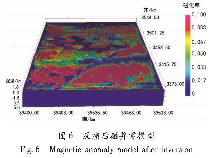
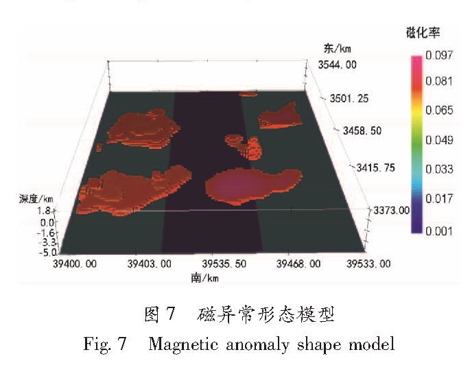
经过45次迭代计算以后,模型达到拟合条件,反演结束。在结果模型中可以得到磁异常的整体分布,去除非异常单元后可得到磁异常区域的深度及形态(图7)。反演后的三维磁异常模型见图6。
图6 反演后磁异常模型
Fig.6 Magnetic anomaly model after inversion
图7 磁异常形态模型
Fig.7 Magnetic anomaly shape model
磁异常三维反演的最大特点是可以很直观地反映模型区域不同深度及不同剖面的磁异常分布。通过比对模型切面,可以分析不同区域不同地层的磁异常分布情况。
如图8所示,可以看出在1.6 km及3.3 km深度时,磁异常的区域、形态均有所不同,磁异常区域整体减小。且在1.6 km深度时,磁异常主要集中在侏罗系(J)地层,而在3.3 km处岩浆岩地层为主要磁异常区域。这符合灰岩为低磁低密度而岩浆岩为高磁高密度的基本原理。
图8 不同深度磁异常分布模型
Fig.8 Magnetic anomaly distribution models at different depths
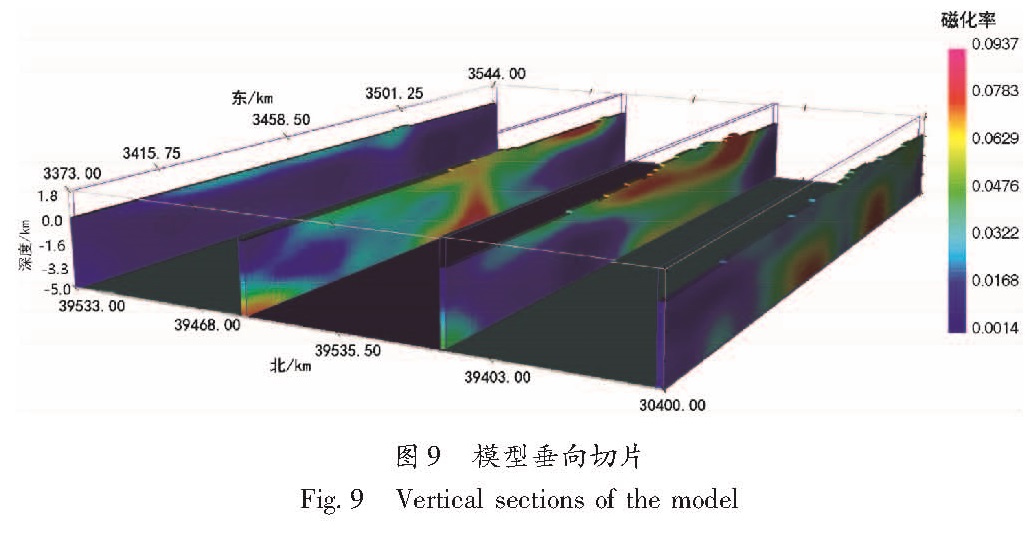
图9是模型由西向东3个不同位置的垂向切片,反映了不同区域地下磁异常体的分布,高磁性体反映了中基性岩体和磁性基地,而对无磁或弱磁的灰岩、红层等区分能力较弱(杨明慧等,2009)。从垂向切面可以看出,模型区域由西向东方向磁异常区域分布差别较大,异常面积呈先增大再减小的趋势,异常埋深则呈不均匀分布。且由于受边界效应影响,模型切片南北两侧边缘由于没有磁测数据支撑导致边缘区域数值较小,部分呈负异常。
图9 模型垂向切片
Fig.9 Vertical sections of the model