基金项目:测震台网青年骨干培养专项——2014年以来云南M6以上地震序列特征分析及震区构造活动性研究(20150426)、国家自然科学基金——小滇西地区发震断层及应力状态研究(41564003)和地震行业科研专项——应用互联网图像搜索引擎技术实现实时地震监测技术的研究(201408018)联合资助.
(1.云南省地震局,云南 昆明 650224; 2.中国科技大学,安徽 合肥 230026; 3.云南大学 资源环境与地球科学学院,云南 昆明 650091)
(1.Yunnan Earthquake Agency,Kunming 650224,Yunnan,China)(2.University of Science and Technology of China,Hefei 230026,Anhui,China)(3.School of Resource Environment and Earth Science,Yunnan University,Kunming 650091,Yunnan,China)
Jinggu MS6.6 earthquake; waveform cross-correlation; double-difference location; focal mechanisms
备注
基金项目:测震台网青年骨干培养专项——2014年以来云南M6以上地震序列特征分析及震区构造活动性研究(20150426)、国家自然科学基金——小滇西地区发震断层及应力状态研究(41564003)和地震行业科研专项——应用互联网图像搜索引擎技术实现实时地震监测技术的研究(201408018)联合资助.
结合波形互相关技术,运用双差定位方法对2014年景谷MS6.6地震及其强余震序列进行重定位。对序列中2.0≤ML≤5.0共730个事件重定位得到649个重定位结果。定位误差在EW向为18 m,NS向为19 m,深度方向为23 m。结果 显示此次景谷地震序列主要沿2个优势方向展布:一个是主震发生后沿NW走向的无量山断裂西支(普文断裂)延长线呈长约20 km的带状分布,一个是12月6日MS5.8和MS5.9两个强余震发生后沿近NS向长度约10 km左右的展布,这可能与西侧的NNE走向的澜沧江断裂及东侧NW走向的无量山断裂西支(普文断裂)共同作用有关,也有可能是发震断层分段破裂或分段活动造成的结果。从深度上看,序列大部分地震集中分布在6~15 km深度范围内,而在12月6日强余震发生几天后,序列地震的深度有一个整体变深的趋势,分布范围主要集中在9~16 km,这与序列位置及走势发生变化有关,也提示了研究区域地质结构的复杂性。我们用全波形模拟法得到了序列中MS≥3.5地震震源机制解,主震北侧发生的地震,震源机制与主震一致性较好; 而主震南侧的地震,其震源机制解主破裂面走向有向NS向偏转的趋势。
Using the double-difference method that combined with waveform cross-correlation,we relocated the Jinggu MS6.6 and its 730 aftershocks with magnitude between 2 and 5 and finally obtained 649 relocated earthquakes,the statistical location error are 18 m in EW,19 m in NS and 23 m in depth direction,respectively.The aftershock sequence presents a zonal shape with lengths of 20km and along the west branch of Wuliangshan fault(Puwen fault).But two strong aftershocks sequence distribution direction has some transformation,mainly along the nearly NS with length of 10 km after the strong aftershocks with MS5.8 and MS5.9.This may be associated with fracture on the west side of NNE direction of the Lancang river fault and on the east side of NW direction of the west branch of Wuliangshan fault(Puwen fault),also may be related to segmental rupture or segmental activity of fault.Most earthquakes are predominately located between 6 km and 15 km.But the depth of the earthquake sequence has the tendency of a whole deeper distribution range are mainly concentrated in 9 km to 16 km a few days later.This indicates the complexity of the regional geological structure.Using full waveform simulation method to get the focal mechanism solution of MS≥3.5 earthquakes,the focal mechanism of the north earthquakes is consisted with the main shock.The strike of plane I of the south earthquakes have a trend towards NS.
引言
2014年10月7日21时49分,在云南省景谷县(23.4°N,100.5°E)发生了MS6.6地震,此次景谷地震震中位于景谷县永平镇,距景谷县城24 km,位于澜沧江以东34 km处。其震源破裂机制属走滑型,震区地质地貌错综复杂。景谷地震的发震断层属于景谷断裂或无量山断裂NW段(徐锡伟等,2014),地震震源破裂过程成像显示断层面上滑动分布比较集中,震源附近的最大右旋滑动量可达45 cm。2014年12月6日2时43分,在同一区域又发生了一次MS5.8的余震,同日18时20分又发生一次MS5.9余震。
滇西无量山断裂北起无量山北麓,向南东经镇源、普洱、漫汤,顺营盘山入老挝,断层走向呈NNW,在云南境内长220 km以上。该断裂带主要由磨黑断裂、普洱断裂和普文断裂3条次级断裂组成,其中,普文断裂始于景谷盆地南端,呈略向西突出的弧形向南延伸,经思茅西侧、普文,至勐醒后转为近南北向延伸至勐腊北,为第四纪活动断裂(洪海春等,2015)。景谷全县地处横断山脉无量山西南段,以山地高原为主,谷坝镶嵌其中,山地、高原、盆地相间分布,总地势由北向南倾斜,渐向东西两翼扩展。澜沧江流入景谷县境迂回西部,该地区以NW向的澜沧江断裂为主体构造,现今构造活动十分强烈,是云南6、7级地震的高发区。1900年以来,此次景谷地震的震中附近100 km范围内共发生5级以上地震38次,6级以上地震12次,7级以上地震2次,最大一次是1988年11月6日的澜沧—耿马7.4级地震。
由于波形互相关技术可以提高震相到时的读取精度,并在很大程度上降低人工读取震相获得相对走时的误差,可以使相对到时的计算达到相当高的精度(黄媛,2008a)。该方法目前在国内外已有广泛应用。在对北加州Hayward断层区域地震定位(Waldhauser,Ellsworth,2000),北加州1984—2003年大量地震的双差定位(Waldhauser,Schaff,2008)以及南加州地震区1984—2002年地震事件的双差定位(Hauksson,Shearer,2005)的研究中,波形互相关方法都得到了大规模的应用并显示出其优越性。在国内,波形互相关方法在地震定位方面的应用不多且仅限于较小规模。例如,赵翠萍(2006)对新疆伽师震源区的150多次地震做了互相关提取走时的尝试,并用于改善定位精度。黄媛等(2008b)在对汶川地震进行基于目录到时的双差定位后,探讨了利用波形互相关技术大规模提取集群地震走时差的可行性和优越性。吕鹏等(2011)结合波形互相关得到的P波到时对汶川地震序列进行了重定位,黄浩和付虹(2014)利用结合波形互相关对盈江地震序列进行双差定位,得到的重定位结果误差在数十米的量级。而对于2014年景谷地震序列,徐甫坤等(2015)利用双差定位法仅对此次景谷地震10月7日—31日期间的余震序列进行了重定位,发现序列分布呈北西向线性展布。为进一步了解强余震活动发生后的序列情况,本研究选取了2014年10月7日—12月31日间的余震序列,结合波形互相关技术,用双差定位法对景谷序列进行分析研究,与现有的结果对比分析,来探讨该序列在震区的时空分布特征。
1 重定位方法和数据
双差地震定位方法最初由Waldhauser和Ellsworth(2000)提出,目前在国内外广泛应用(Waldhauser,Schaff,2008; Hauksson,Shearer,2005; 房立华等,2011; 杨智娴等,2003; 黄媛等,2008b)。这是一种很有效的相对地震定位方法,它利用震相的走时差反演地震群体中每次地震关于该地震丛集矩心的相对位置,并不需要主事件,能够有效地消除震源至台站共同传播路径效应,相对走时差数据的选用大大减少了地壳模型不精确导致的误差,即对地壳速度模型的依赖性相对较小。其基本思想是:如果2个地震震源之间的距离小于事件到台站的距离和速度不均匀的尺度,那么震源区和这个台站之间的整个射线路径几乎相同。这时,在某个台站观测到的2个事件的走时差来自于事件之间的空间偏移。双差法的基本方程(Waldhauser,Ellsworth,2000)如下:
Δtjk-Δtik=-SjkΔXj+SikΔXi+εjk-εik(1)
式中:Δtik和Δtjk分别对应地震i和j到台站k的到时残差; Xi和Xj分别是两个震源的位置矢量; Sik和Sjk是两个震源位置到台站k的慢度矢量; εik和εjk分别为地震在台站的到时拾取。
针对人工标定的震相到时因人为因素可能存在不够精确或者错误的情况,本文将波形互相关方法引入到地震震相的识别和到时的计算确定中。由于双差定位过程中并不要求提供绝对到时,所以利用波形互相关方法求取相对到时是有效的做法。此种方法的前提是认为空间上分布比较近,并且具有相同破裂机制的地震事件,在同一个台站上记录到的波形可能具有一定的相似性(Richardset et al,2006)。据此对同一台站记录到的不同地震的波形,两两之间做时域或频域的互相关。若在预设窗口内的相关系数高于给定阈值,则认为波形匹配符合要求,保留其相对时差(黄嫒,2008a)。波形互相关方法用到了地震图包含的更丰富的信息,可以在很大程度上降低通过直接拾取震相获得相对走时的误差。通过分析互相关在当地以及区域信号中的应用,结合地震报告中常规震相到时读数,使用双差算法可以一次获取大量地震的高精度相对位置。
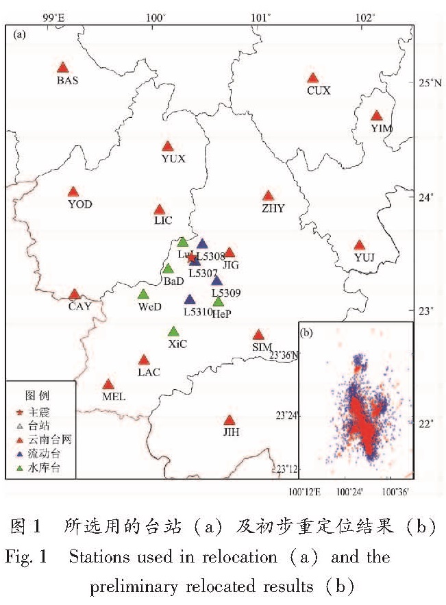
本文从云南测震台网记录中挑选了2014年10月7日—12月31日间有多台记录的景谷地震序列的观测报告,以主震为圆心,选择了半径200 km范围内的台站(包括云南台网的区域台、国家台、水库台、流动台),共计10 134次地震事件用于研究(图1)。我们参考了云南台网速报模型及其它反演方法的结果(王椿镛等,2002; 胥颐等,2013; 徐甫坤等,2015),经过对比尝试,确定使用的一维速度模型如表1所示。经过双差定位后得到10 005个地震的重定位结果,如图1b所示,蓝色为云南台网10 134个地震的人工编目结果,红色为双差定位后得到的10 005个地震事件结果,可以看到双差定位后减少了原序列分布的离散性,条带状分布更为明显。定位误差为EW向352 m,NS向419 m,深度误差448 m,走时误差148 ms。
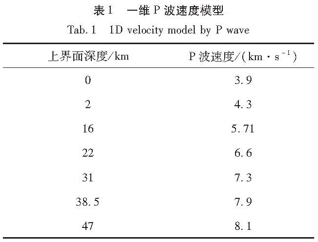
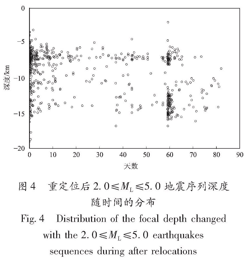
此次景谷地震序列3个MS≥5地震,震级最小的也达到MS5.8,这与该序列的其它地震震级相差至少近1级,若一起做互相关,就会造成波形相似度低的问题,再考虑到小震信噪比较差的问题,我们在做波形互相关时,选取了2.0≤ML≤5.0的730个地震事件。首先将所选事件波形在1~10 Hz频段进行滤波,P波窗长取初至P波前1.5 s至P波后1.5 s,同时考虑到由于P波后续震相的影响导致S波到时读取的准确度低于初至P波,对于S波我们使用较长的互相关窗长,即S波前2.5 s至S波后2.5 s。通过互相关计算,我们选取了互相关系数在0.7以上的到时差数据,得到P满足波筛选条件的数据159 846对,满足S波互相关条件的数据57 735对。之后把波形互相关数据结合人工拾取的震相数据共同进行双差定位,最终得到了649个事件的重定位结果。定位误差为EW向18 m,NS向19 m,深度23 m,走时误差7 ms。
2 重定位结果分析
2.1 空间展布特征现今GPS观测结果表明(Wang et al,2001; Zhang et al,2004),青藏高原东部的地壳块体相对于华南地块发生顺时针旋转,川滇地块向相对稳定的欧亚大陆逃逸; 但在滇西南地区,地壳块体的运动方向转向SSW,几乎正交于NW走向的无量山断裂带和澜沧江断裂带(程远志等,2016)。根据中强震的震源机制(钱晓东等,2011),景谷地区主要受2个方向的应力作用:一是来自印缅块体的NE、NNE和NNW向挤压; 二是川滇块体的SE、SSE向运动,它们共同控制了景谷地区内的断裂活动和应力积累。从图2a震后12 h的序列发展情况看,景谷地震序列主要沿近NW向(AA')呈带状展布,在震后12 h左右到达NW端; 图2b可以明显看出,截至2014年12月31日,该地震序列主要沿2个优势方向展布,一个是主震发生后沿NW走向的无量山断裂西支(普文断裂)延长线呈长约20 km的带状分布,一个是12月6日MS5.8和MS5.9两个强余震发生后,序列的展布方向发生变换,主要沿近NS向(CC')长约10 km展布,这可能与西侧的NNE走向的澜沧江断裂及东侧无量山断裂西支(普文断裂)共同作用有关。此外,可以看到近NE向(BB'也有少量地震分布,这与NE走向的景谷断裂有关。与徐甫坤等(2015)仅用了2014年10月7日—10月31日共25天的余震数据所做的双差定位结果相比,同样体现了景谷序列在主震后分布主要延NW向展布这一特点,而由于本研究所选序列时间范围较长,包含了12月6日强余震后的序列信息,因此发现了序列展布方向由NW向NS转变这一特点。
由于做波形互相关时对波形相似度的考虑只选取了2.0≤ML≤5.0的地震,本研究中涉及MS6.6主震及2个MS≥5.0余震的定位结果,是对10 134个地震仅做了双差定位未进行波形互相关的结果,从图2上可明显看到,主震位置(23.385°N,100.481°E)(红色五角星)、深度14 km,这一位置与人工通过MSDP软件采用Loc3dSB川滇3D定位方法得到的结果(23.374°N,100.465°E)(蓝色五角星)、深度19 km相比,往东北方向偏了3 km左右,人工定位的结果在序列空间展布条带上显得略偏西,而经过双差定位后,主震位置往东北向偏移了约3 km后,位于序列正中,更符合此次序列地震的空间分布特征。
相比之前只用双差定位结果,引入波形互相关后,定位误差从数百米量级降到了数十米量级。通过对比图1b红色双差定位和图2引入波形互相关的结果,我们看到序列分布明显更为收敛,消除了原本散布在主序列周围的离散点,从而使得序列的条带状分布更为清晰,图1红色部分能看到,较人工定位结果有一定程度的收敛,但2个5级以上强余震后,能看到序列分布有一定南延,但方向不是很清晰,而从图2b的结果可以看到清楚地看到强余震之后序列分布由先前的NW向转为NS向。
2.2 深度剖面特征从序列的深度沿不同剖面的分布情况来看(图3),景谷地震主震位于序列底部,其下仅有少部分地震分布,2个5级以上强余震也位于序列底部。整体来看深度沿剖面的分布情况与该剖面的地形起伏有关,地势高的地方震源深度多分布于5~10 km,而地势低的地方震源深度多分布于15 km左右。在沿NW向的AA'剖面上,序列的深度从A至A'(西北—东南方向)由浅至深分布,西北端地势较高,深度主要集中在5~10 km,从中段开始逐渐加深,主要集中在7~15 km,结合时间来看,12月6日强余震发生后,序列的空间分布发生变换,此后的震源深度在AA'剖面的分布主要体现在东南端,深度分布于6~16 km之间。在沿NE向的BB'剖面上,序列深度从B至B'(西南—东北)呈较为明显的带状分布,同样由于强余震的关系,从时间上看能明显看到此方向上的2个带状深度分布。这一剖面上强余震发生前的地震序列深度呈带状近竖直集中分布在中段3~16 km区间,强余震发生后深度呈带状近竖直集中分布于偏东南段5~17 km区间。在沿近NS向的CC'剖面上,序列深度从C至C'(北—南方向)表现为从北端至中段主要是强余震发生前,序列深度主要在5~16 km区间分布,到中段主要集中于12~15 km,到强余震发生后在南段分布于6~17 km。整个序列在8~11 km深度范围明显缺震,且此范围上、下地震密度差别大,反映了这一深度可能是研究区基底与盖层之间的分界。另外,思茅—景洪存在着大致延伸到10 km左右的低Q值区,云南地区Q值的横向变化及其分布特征与该区构造活动、地震活动及热活动状态的区域差异有较好的一致性(苏有锦,2009),因此在低Q值区的这一深度范围内地震活动强烈,也许能够解释本研究在深度上反应出的上下地震密度差别大的现象。
图3 景谷地震序列重定位后深度沿不同剖面的分布
Fig.3 Distribution of focal depth of the Jinggu earthquake sequence along the different profiles图4为重定位后2.0≤ML≤5.0地震序列深度随时间的分布,从图中可以看出,在强余震发生前此序列深度分布稳定在6~15 km,而在12月6日强余震发生几天后,序列地震的深度有一个整体变深的趋势,分布范围主要集中在9~16 km,这与序列位置及走势发生变化有关,也提示了研究区域地质结构的复杂性。
图4 重定位后2.0≤ML≤5.0地震序列深度随时间的分布
Fig.4 Distribution of the focal depth changed with the 2.0≤ML≤5.0 earthquakes sequences during after relocations3 震源机制解特征分析
传统上常采用P波初动或单一波形的方法进行震源机制的反演。而这些方法存在着几个不足:(1)P波初动需要大量方位角和震中距分布较好的台站;(2)对于节面方位角附近的地震记录,很难判断P波初动的极性;(3)P波初动法无法得到地震的深度和震级(谢祖军等,2012)。而利用波形反演方法可克服这些不足,从而使结果更为精确可靠。全波形模拟法(Xu et al,2010; Herrmann et al,2011)模拟的是高频的速度值而不是低频的位移值,这就能更好地降低低频的台站和仪器噪音的干扰。波形反演的第一个步骤是计算格林函数,假设震源时间函数是一阶跃方程,同时假设震源在空间上为一点源。在这些假设基础上,运用fk算法计算理论波形。速度模型的选择如表1所示,波形模拟是通过对整个深度范围,在每一深度上对由走向、倾角、滑动角组成的格点进行格点扫描。对于每一深度,将已去除仪器响应并旋转到径向、切向、垂直向三个分量的速度值和已计算好的理论地震图进行对比。当观测到的波形与理论波形的波形相关达到最大时,我们认为该深度的走向、倾角、滑动角为该地震的震源参数。因此运用全波形模拟法对该地震序列中MS≥3.5记录清晰的地震进行了震源机制解的计算,从表2中的结果上看,此次景谷序列地震震源机制总体一致性较好,均为走滑型。
表2 景谷序列中MS≥3.5地震的震源机制解
Tab.2 The focal mechanism solutions of MS≥3.5 events in the Jinggu earthquake sequence本研究所计算得到的主震震源机制与表3所列其它机构给出的结果基本一致,此次景谷地震的震源机制节面1走向为NW,与无量山断裂(普文断裂)走向一致,参考序列的空间分布来看,主震后序列主要沿NW向展布,因此节面1为主破裂面; 而节面2的走向为NE,与景谷断裂走向接近,这一方向上也有少量地震呈带状分布。从图5可以看出,在主震北侧发生的序列,震源机制与主震一致性较好,走向基本在NW-NNW之间,变化不大; 而在主震南侧,接近序列南端发生的较大地震震源机制节面1走向有向NS向偏转的趋势。11月15日—12月4日之间发生的地震,节面1走向近NS,这可能与后续12月6日2个5级以上强余震发生后序列的空间展布方向由NW向变换为NS向有关。而2个强余震震源机制与主震较接近,其后序列展布方向的改变可能是景谷断裂与无量山断裂(普文断裂)共同作用的结果。此外,从震级上看,本研究得到的结果MW6.1与IRIS网站上的结果一致,而郑勇等(2009)通过比较中国台站和IRIS台站记录的振幅发现,中国台站的振幅小于IRIS的记录,这就容易导致中国本地地震台站反演得到的矩震级比IRIS结果偏小0.2~0.3,但从本研究计算的矩震级与IRIS提供的矩震级一致,可看出我们采用的全波形模拟法由于是选用互相关函数作为反演的目标函数,而互相关函数主要依赖理论波形和实测波形的相位(陈浩,陈晓非,2016),这种方法可以避开振幅对震源机制反演的影响。
图5 景谷序列MS≥3.5地震震源机制解
Fig.5 The focal mechanism solutions of MS≥3.5 earthquakes in the Jinggu earthquake sequence4 结论
经过重定位,此次景谷地震序列主要沿2个优势方向展布,一个是主震发生后沿NW走向的无量山断裂西支(普文断裂)延长线呈长约20 km左右的带状分布,一个是12月6日MS5.8和MS5.9两个强余震发生后序列的展布方向发生变换,主要沿近NS向CC',约10 km的展布,这可能与西侧的NNE走向的澜沧江断裂及东侧无量山断裂西支(普文断裂)共同作用有关。地震的迁移,实际上可能为断层的分段破裂或断层的分段活动(吴中海等,2014; 黄小龙等,2015),但是目前关于地震迁移规律的认识多建立在统计学基础上,具体的地震迁移的内部机理还不清楚。虽然本次地震的发震断层活动性较弱,规模较小,看不到分段式的同震地表破裂,甚至地貌特征也不明显,但景谷震群活动中余震的分布由NW向NS迁移,实际上是断层分段破裂或分段活动的一种具体表现,即断裂扩展过程中遇到早期先存的NE向构造带上岩桥障碍体的临时阻碍,突破障碍后进一步向南扩展的结果(吴坤罡等,2016)。此外,可以看到近NE向BB'也有少量地震分布,这与NE走向的景谷断裂有关。重定位后主震位置(23.385°N,100.481°E)、深度14 km,比原始目录(23.374°N,100.465°E)、深度19 km相比,往东北方向偏了3 km左右,该结果与序列空间分布对应更好。而结合波形互相关进行双差重定位后,与做波形互相关前单纯的双差定位相比,2水平向及深度误差由原来的百米量级降到十米量级,到时误差也有明显改善,重定位后序列分布特征清晰,这也说明了波形互相关技术在运用双差定位中的优势所在。
从深度上看,景谷地震主震位于序列底部,其下仅有少部分地震分布,2个5级以上强余震也位于序列底部。从深度沿不同剖面的分布情况能明显看到12月6日的2个强余震类似一条分界线,使景谷序列空间分布特征发生明显改变。整个序列中超过3/4的地震集中分布在6~9 km和12~15 km两个优势深度范围内,整个序列在8~11 km深度范围明显缺震,且以此范围为界,呈现出上多下少的特点,这也说明此次地震序列的在深度分布的不均性。主震刚发生后深度分布稳定在6~15 km,而在12月6日强余震发生几天后,序列地震的深度有一个整体变深的趋势,分布范围主要集中在9~16 km,这与序列位置及走势发生变化有关,可能是发震断层分段破裂或分段活动造成。
此次景谷地震的主震震源机制主破裂面走向为NW,与无量山断裂(普文断裂)走向一致。在主震北侧发生的序列,震源机制与主震一致性较好,走向基本在NW-NNW之间,变化不大; 而在主震南侧,接近序列南端发生的较大地震震源机制节面1走向有向N发展的趋势,这一特征与序列的空间分布特征相对应。
本研究得到四川省地震局吴微微、云南省地震局陈佳的支持与帮助,两位审稿专家提出了宝贵意见和建议,在此一并表示衷心感谢。
- 陈浩,陈晓非.2016.2014年10月7日云南景谷MW6.2地震震源机制解反演和重定位[J].地球物理学进展,31(4):1413-1418.
- 程远志,汤吉,邓琰,等.2016.云南景谷MS6.6地震震源区深部电性结构及其孕震环境[J].地震地质,38(2):352-369.
- 房立华,吴建平,张天中,等.2011.2011年云南盈江MS5.8地震及其余震序列重定位[J].地震学报,33(2):262-267.
- 洪海春,尤捷,陶小三,等.2015.2014年云南鲁甸地震和景谷地震的震害对比研究[J].地震工程学报,37(4):1013-1022.
- 黄浩,付虹.2014.结合波形互相关的双差定位方法在2011年盈江地震序列中的应用[J].地震研究,37(2):210-215.
- 黄小龙,吴中海,赵小艳,等.2015.2014 年5 月云南盈江MS5.6,MS6.1地震发震构造分析[J].地球学报,36(6):761-770.
- 黄媛,吴建平,张天中,等.2008a.汶川8.0级大地震及其余震序列重定位研究[J].中国科学:地球科学,38(10):1242-1249.
- 黄媛.2008b.结合波形互相关技术的双差算法在地震定位中的应用探讨[J].国际地震动态,(4):29-34.
- 吕鹏,丁志峰,朱露培.2011.结合波形互相关的双差定位方法在2008年汶川地震余震序列中的应用[J].地震学报,33(4):407-419.
- 钱晓东,秦嘉政,刘丽芳.2011.云南地区现代构造应力场研究[J].地震地质,33(1):91-106.
- 苏有锦.2009.云南地区地震波衰减(Q值)结构反演成像研究[D].北京:中国科学技术大学.
- 王椿镛,MOONEY W D,王溪莉,等.2002.川滇地区地壳上地幔三维速度结构研究[J].地震学报,24(1):1-16.
- 吴坤罡,吴中海,徐甫坤,等.2016.滇西南2014年景谷中—强震群的地质构造成因——茶房—普文断裂带贯通过程的构造响应[J].地质通报,35(1):140-151.
- 吴中海,周春景,冯卉,等.2014.青海玉树地区活动断裂与地震[J].地质通报,33(4):419-469.
- 谢祖军,郑勇,倪四道,等.2012.2011年1月19日安庆舰ML4.8地震的震源机制解和深度研究[J].地球物理学报,55(5):1624-1634.
- 胥颐,杨晓涛,刘建华.2013.云南地区地壳速度结构的层析成像研究[J].地球物理学报,56(6):1904-1914.
- 徐甫坤,刘自凤,张竹琪,等.2015.2014年云南景谷MS6.6地震序列重定位与震源机制解特征[J].地球科学:中国地质大学学报,40(10):1741-1754.
- 徐锡伟,程佳,许冲,等.2014.青藏高原块体运动模型与地震活动主体地区讨论:鲁甸和景谷地震的启示[J].地震地质,36(4):1116-1134.
- 徐锡伟,于贵华.2014.云南省普洱市景谷傣族彝族自治县(北纬23.3度,东径100.5度)5.9级地震发震构造图[EB/OL].(2014-12-06)[2017-3-15].http://www.eq-igl.ac.cn/upload/images/2014/12/6195317537.jpg.
- 杨智娴,陈运泰,郑月军,等.2003.双差地震定位法在我国中西部地区地震精确定位中的应用[J].中国科学:地球科学,33(增刊1):129-134.
- 赵翠萍.2006.1997—2003年伽师震源区特征的地震学方法研究[D].北京:中国地震局地球物理研究所.
- 郑勇,马宏生,吕坚,等.2009.汶川地震强余震(MS≥5.6)的震源机制解及其与发震构造的关系[J].中国科学:地球科学,39(4):413-426.
- HAUKSSON E,SHEARER P.2005.Southern California hypocenter relocation with waverform cross-correlation,part 1; Results using the double-difference method[J].Bull Seism Soc Amer,95(3):896-903.
- HERRMANN R B,MALAGNINI L,MUNAFO I.2011.Regional moment tensors of the 2009 L'Aquila earthquake sequence[J].Bull Seismol Soc Am,101(3),210-215.
- RICHARDS P G,WALDHAUSER F,SCHAFF D,et al.2006.The applicability of modern methods of earthquake location[J].Pure Appl Geophys,163(2-3):351-372.
- WALDHAUSER F,SCHAFF D P.2008.Large-scale relocation of two decades of Northern California seismicity using cross-correlation and double-difference methods[J].J Geophys Res,113(B8):4177-4183.doi:10.1029/2007JB005479.
- WALDHAUSER F.,ELLSWORTH W L.2000.A Double-Difference Earthquake Location Algorithm:Method and Application to the Northern Hayward Fault,California[J].Bull Seism Soc Am,90(6):1353-1368.
- WANG Q,ZHANG P Z,FREYMUELLER J T,et al.2001.Present-day crustal deformation in China constrained by global positioning system measurements[J].Science,294(5542):574-577
- XU Y,HERRMANN R B,KOPER K D.2010.Source parameters of regional small-to-moderate earthquakes in the Yunnan-Sichuan region of China[J].Bull Seismol Soc Am,100(5B):2518-2513.
- ZHANG P Z,SHEN Z K,WANG M,et al.2004.Continuous deformation of the Tibetan plateau from global positioning system data[J].Geology,32(9):809-812.