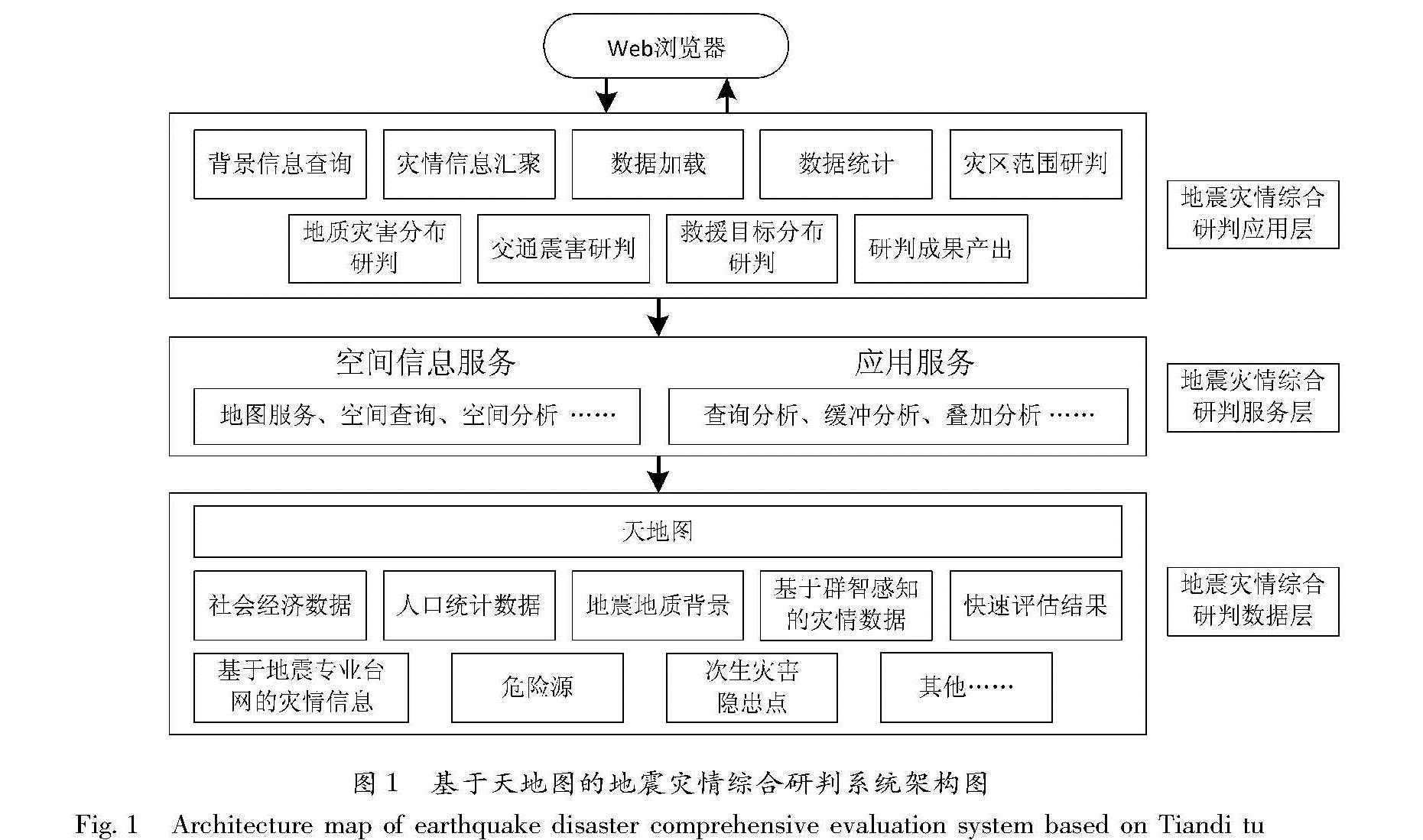
2.1 结构设计
基于天地图的地震灾情综合研判系统主要采用基于B/S的3层体系架构,分为应用层、服务层和数据层,如图 1所示。
图1 基于天地图的地震灾情综合研判系统架构图
Fig.1 Architecture map of earthquake disaster comprehensive evaluation system based on Tiandi tu
2.1.1 应用层
地震灾情综合研判系统应用层即界面层,用于显示数据和接收用户输入的数据,为用户提供一种直接交互式操作的界面。系统充分利用网络地图与用户交互性强的特点,以天地图为背景,以Web客户端的形式提供背景信息查询、灾情信息汇聚、数据加载、数据统计、灾区范围研判、地质灾害分布研判、交通震害研判、救援目标分布研判、研判成果产出等应用工具,为不同地区、不同领域的地震应急专家进行灾情协同研判时提供各类背景信息、灾情信息和研判工具。
2.1.2 服务层
该系统的服务层即业务逻辑层,它一方面接受浏览器端的信息服务请求,根据请求对各类空间数据或属性数据进行处理、地图操作; 另一方面处理相应的数据请求,维护管理系统信息。服务层提供的服务包括空间信息服务和应用服务:空间信息服务是指地图服务、空间查询、空间分析等,根据应用层的请求返回对应的地理信息; 应用服务指各种查询分析、缓冲分析、叠加分析、统计分析、聚类分析等,将各类空间信息服务和应用服务按照业务流程组合起来,从而为浏览器端的信息服务请求返回结果。如利用空间数据、人口数据、经济数据、重点目标数据、居民地数据等叠加,分析承灾体的受灾特征,辅助进行灾情研判; 利用空间数据、灾情数据、余震数据、强震数据等进行叠加分析,分析灾区范围分布、重灾区分布等。
2.1.3 数据层
数据层的任务是解析服务层发出数据请求,提供服务层所需要的数据,并对数据进行维护、访问、更新等。考虑天地图数据现势性强、地理底图统一的优势,该系统将天地图作为基本空间数据来源和数据汇聚的平台,所需的基础地理空间数据如道路、学校、居民点、行政区划等,主要通过天地图API提供。将社会经济数据、人口统计数据、地震地质背景、危险源、次生灾害隐患点等应急基础数据,基于群智感知和地震专业台网等灾情数据,将快速评估结果等各类数据汇聚于天地图平台,统一为统计分析、灾情研判提供研判数据支撑。
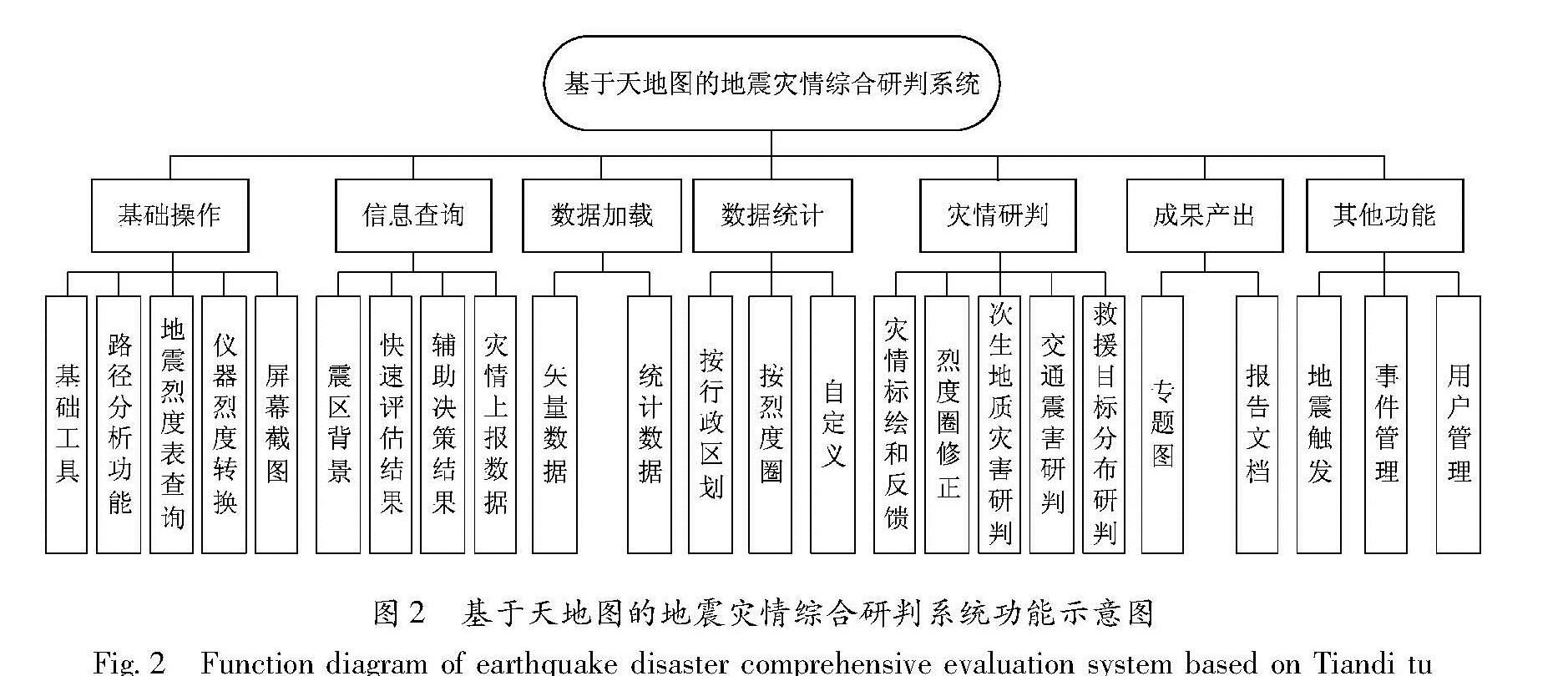
2.2 功能设计
该系统功能主要包括基础操作、信息查询、数据加载、数据统计、灾情研判、成果产出以及其他功能,其他功能包括地震触发、事件管理和用户管理,如图2所示。
图2 基于天地图的地震灾情综合研判系统功能示意图
Fig.2 Function diagram of earthquake disaster comprehensive evaluation system based on Tiandi tu
(1)基础操作:提供基本的地图操作,为地图浏览以及灾区背景信息、多源灾情信息的可视化提供基本保障。提供距离和面积测量等基础工具,提供路径分析、地震烈度表查询、震级与能量转换、仪器烈度转换、屏幕截图等功能,为专家开展灾情协同综合研判提供基础操作和工具。
(2)信息查询:以报表和图的形式提供震区背景、快速评估结果、辅助决策结果、灾情上报数据等查询。震区背景查询可以根据输入的距离要求提供所需范围内的乡镇驻地、居民地、学校、医院、重点目标、历史地震、救援力量、应急物资、疏散场地、危险源等分布信息。快速评估结果查询提供地震灾害损失快速评估系统产出的所有快速评估结果,如建筑物破坏、人员伤亡、经济损失等。辅助决策结果查询提供系统产出的各类辅助决策信息。灾情上报数据查询可提供基站退服信息、电网节点破坏、热力图、舆情监控与分析等基于社会源的灾情信息,全省“三网一员”人员通过灾情上报APP查询灾情信息,遥感灾情提取信息以及现场灾情调查信息等。
(3)数据加载:提供各类矢量数据和统计数据的加载功能,包括评估影响场、现场烈度圈、余震数据、强震数据、现场烈度点、基础地理数据和其他外部数据。
(4)数据统计:提供多种方式的数据统计功能,包括按照行政区划、烈度圈以及自定义的统计,为灾情综合研判提供灵活的数据统计功能。
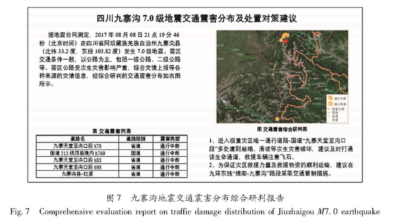
(5)灾情研判:提供灾情标绘和反馈、烈度圈修正(灾区范围研判)、次生地质灾害研判、交通震害研判、救援目标分布研判等功能。灾情标绘与反馈功能是在天地图底图背景上,采用点、线、面结合的方式实现多源灾情信息的实时标绘,还提供常用的标注工具,便于专家手动标注灾情。烈度圈修正以预评估的地震烈度圈为基础,结合灾情上报信息、烈度速报信息、现场调查信息等多源灾情数据以及余震展布和灾区背景信息,采用烈度圈勾画、平移、方向修改、缩放、抽稀、圆滑等工具,通过人机交互实现烈度圈的动态修正。次生地质灾害研判基于修正后的烈度圈、地形地貌、坡度、岩性和地质灾害隐患点等基础数据,通过空间分析给出次生地质灾害风险评估结果,再结合多源灾情信息中的地质灾害信息,人机交互最终给出地质灾害研判结果。交通震害研判功能基于修正的烈度圈、次生地质灾害分布和交通道路基础数据,通过空间分析评估道路震害分布,再结合多源灾情信息中的交通道路破坏信息,最终确定交通道路的震害分布。救援目标分布研判功能以修正的烈度圈、次生地质灾害研判结果、居民地分布基础数据为基础,结合多源灾情信息中的人员伤亡数据,确定救援目标的分布,以点或面的方式在地图上展示。
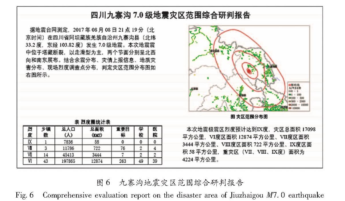
(6)成果产出:以专题图和报告文档两种方式生成。专题图包括基础背景信息图、历史灾情分布图、现场调查信息分布图、灾情上报分布图、灾区范围分布图、人员伤亡分布图、次生灾害分布图、交通震害分布图、救援目标分布图等。基于研判的灾情信息,采用图文结合的方式,产出灾区范围综合研判报告、次生灾害分布及处置对策报告、交通震害分布及处置对策报告、人员伤亡与救援目标分布综合研判报告以及救援目标指引报告。
(7)其他:地震触发提供手动触发地震功能,包括真实地震、地震演练和联调测试3个模式。事件管理提供震害事件设定、结束等管理功能。版本管理提供不同级别用户灾情研判成果版本管理功能。用户管理提供与用户信息相关的管理功能。
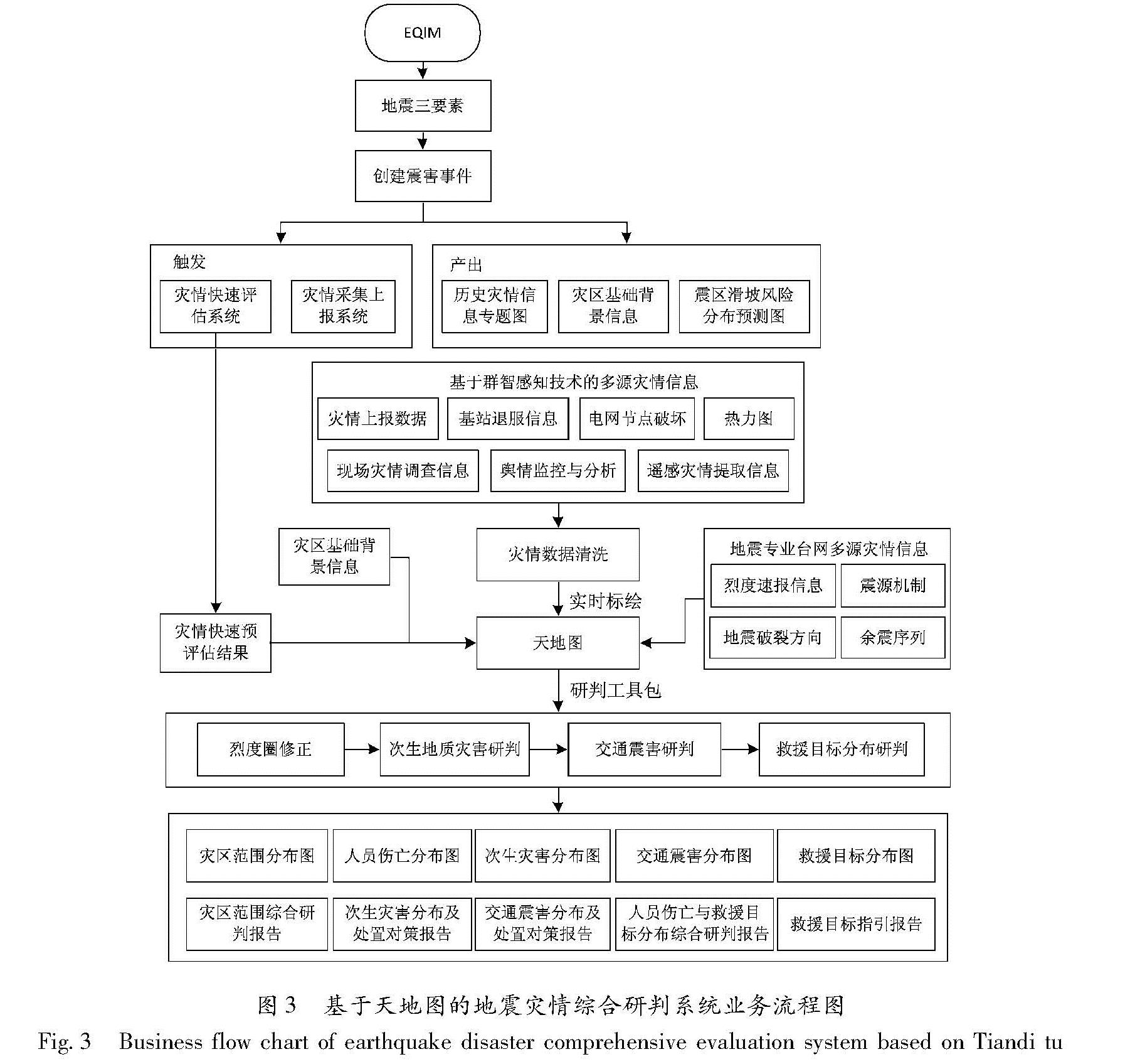
2.3 业务流程
基于天地图的地震灾情综合研判系统应用场景为破坏性地震应急救援,其系统业务流程如图3所示。
(1)从EQIM平台自动获取破坏性地震的地震三要素信息,创建震害事件,自动快速触发灾情快速评估系统、灾情采集上报系统,同时快速产出灾区基础背景信息、历史灾情信息专题图和震区滑坡风险分布预测图。
(2)实时汇集基于群智感知技术的多源灾情信息,包括灾情上报信息、基站退服信息、电网节点破坏、热力图、舆情监控与分析、遥感灾情提取信息、现场灾情调查信息等。经过灾情数据清洗,灾情信息将被实时标绘在天地图底图上,便于后续综合研判和重大灾情处置应用,并分批次产出各种来源灾情信息分布图。重大灾情处置即对于人员伤亡、重大次生灾害等重要灾情信息的处置,包括下发至灾情上报员进行复核,以及一键上报到指挥长。
(3)将烈度速报信息、震源机制、地震破裂方向、余震序列等基于地震专业台网的多源信息,统一汇聚到天地图平台。灾情快速评估计算完成后,灾情协同综合研判系统将自动加载评估结果并进行状态提示。
(4)结合基于群智感知技术的多源灾情信息、基于地震专业台网的多源信息、灾情快速预评估结果和灾区基础背景信息,研判专家利用系统提供的研判工具包,在震后0.5,1,2,4,6,12,24 h等时间节点依次开展烈度圈修正、次生地质灾害研判、交通震害研判和救援目标分布研判等协同工作。之后,系统依次自动产出灾区范围分布图、人员伤亡分布图、次生灾害分布图、交通震害分布图、救援目标分布图等专题图,并生成灾区范围综合研判报告、次生灾害分布及处置对策报告、交通震害分布及处置对策报告、人员伤亡与救援目标分布综合研判报告以及救援目标指引报告,为地震应急救援工作提供动态、全方位的灾情信息支持。
图3 基于天地图的地震灾情综合研判系统业务流程图
Fig.3 Business flow chart of earthquake disaster comprehensive evaluation system based on Tiandi tu