基金项目:国家重点研发计划项目(2018YFC1504504)资助.
(Yunnan Earthquake Agency,Kunming 650224,Yunnan,China)
the Yangbi MS6.4 earthquake; multi-source data; the worst-hit zone
备注
基金项目:国家重点研发计划项目(2018YFC1504504)资助.
引言
破坏性地震发生后,快速判定灾害规模、抢救人民生命财产、转移安置灾民、最大程度减轻灾害损失是抗震救灾工作首要任务。尤其是在重特大地震发生后,破裂范围随着震级和震源机制不同,覆盖十几至数百千米,破裂延续时间可以从十几秒到数百秒(张勇等,2013; 岳汉等,2020),导致地震极灾区通信、电力设施设备受损,极大影响灾情信息的迅速获取。因此,在震后2 h的灾情黑箱期内,利用通信基站、余震序列、仪器烈度等物联网和互联网多源数据来判断地震极灾区的分布范围、展布方向,可为政府部门确定重点救援区域、调派救援力量和物资提供重要的信息支撑和决策依据(聂高众等,2012; 曹彦波等,2018)。
目前,基于地震烈度衰减的数学模型方法是国内地震部门各级应急指挥中心软件系统集成的主流算法之一(汪素云等,2000; 张方浩等,2016),该算法主要利用地震参数快速计算地震影响范围,生成以微观震中为圆心的观侧等效破裂的椭圆(线源)面,最高烈度区就是极灾区的影响范围,极灾区长轴初判方向一般为离震中最近的活动断裂方向。由于地震烈度衰减关系是通过对历史地震烈度长短轴回归分析得到,无法体现出由于震源破裂过程不同而导致的地震灾害分布差异,因此,用烈度衰减关系估计的最高烈度、极灾区大小、方向和宏观震中位置往往与实际烈度分布存在较大偏差(王德才等,2013)。2010年玉树7.1级地震计算出的影响场震中位于人烟稀少的无人区,而实际宏观震中却位于人口稠密的结古镇; 在2014年鲁甸6.5级地震影响场快速评估过程中,由于灾区活断层数据不准确,导致初期快速评估计算出的影响场长轴是NE向,最高烈度计算值仅为Ⅷ度,而实际的长轴是NW向,最高烈度计算值为Ⅸ度。针对上述问题,国内外众多学者开展了震后极灾区判定技术方法研究。代表性的方法主要有:①基于强震动观测数据判定方法(李山有等,2002; 梁永朵等,2015; Kodera et al,2018; 关曙渊等,2020; 段洪杰等,2020),如美国的ShakeMap系统,在高密集监测台网支持下,利用震级、烈度与PGA、PGV的关系进行拟合生成仪器烈度分布图(Wald et al,1999); ②基于震源机制和余震序列数据方法(白仙富等,2011; 王伟锞等,2011; 张苏平等,2013; 郑韵等,2015,2018),杨天青等(2015)利用震后数小时的余震序列数据和震源机制解,通过分析数据时空展布特征,插值拟合快速判定极灾区范围和展布方向; ③基于地震参数评估方法,聂高众和徐敬海(2018)通过分析极震区烈度与地震参数的相关性关系,拟合了一种以正式发布的地震震级、震源深度为输入参数的极震区烈度快速评估模型。
近年来,随着空间对地观测技术、互联网、物联网、深度学习、人工智能等高新技术的飞速发展,有部分学者基于遥感技术(王晓青等,2015a,b; 张景发等,2018; 李金香等,2018; 郭建兴等,2020),基于无人机影像识别技术(许建华等,2017; 周洋等,2017; 杜浩国等,2018; 李金香等,2020)、监控视频源识别技术(李东平等,2017,2019; 郭志宇,2017; Li et al,2021)、社交媒体感知技术(徐敬海等,2015; 曹彦波等,2017; 薄涛等,2018)、互联网IP地址定位技术(李兆隆等,2017; 吴艳梅等,2019)、手机信令数据(张勇等,2018; 张小咏等,2018; 庞晓克,2019)以及震感、人员伤亡、房屋破坏等多源地震灾情信息融合方法(胡素平,帅向华,2012; 郭红梅等,2015; 杨天青等,2016; 李芋均等,2020)等多种大数据时代的技术方法进行地震极灾区的识别和提取。本文在参考前人研究基础上,以2021年5月21日漾濞MS6.4地震为例,利用多源数据融合方法快速判定极灾区范围和展布方向,为地震应急处置工作提供信息支撑。
1 研究方法与数据源
2 研究结果
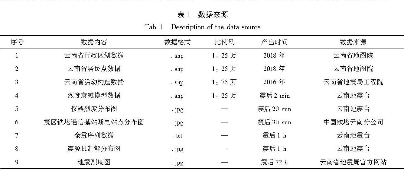
2021年5月21日21时48分34秒,云南省漾濞县(25.67°N,99.87°E)发生MS6.4地震,震源深度8 km。地震发生后,云南地震灾害应急指挥中心快速响应; 震后2 min,基于地震烈度衰减模型,利用评估系统快速计算生成了地震极灾区的空间分布范围和方向; 震后20 min,根据预警工程烈度速报产出结果,提取仪器烈度极灾区影响范围; 震后30 min到1 h,利用漾濞震区铁塔通信基站断电站点分布和余震序列分布空间数据点集拟合得到两种数据源的极灾区空间分布状况。
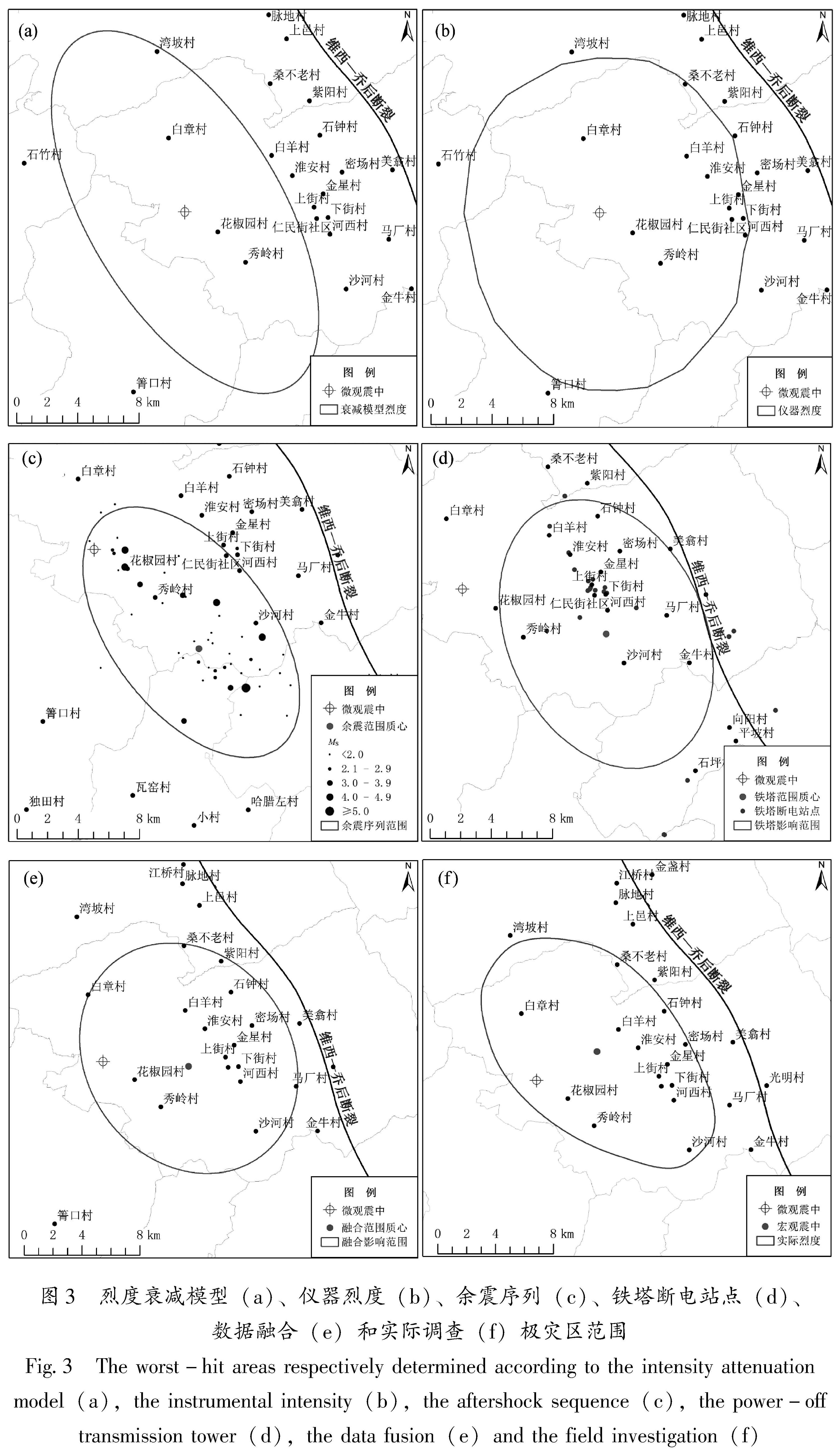
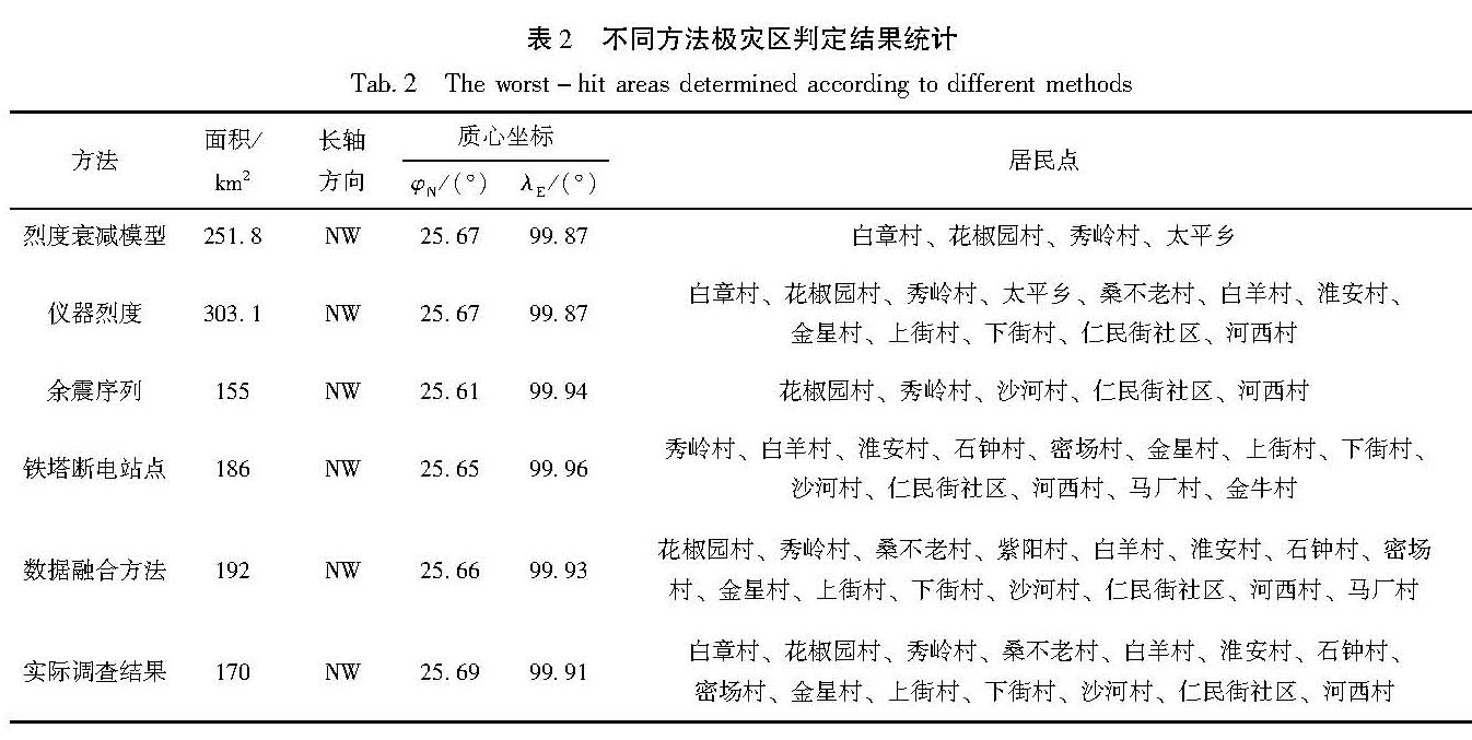
基于烈度衰减模型、仪器烈度、余震序列和铁塔断电站点4种方法拟合得到极灾区,结果如表2、图3所示。
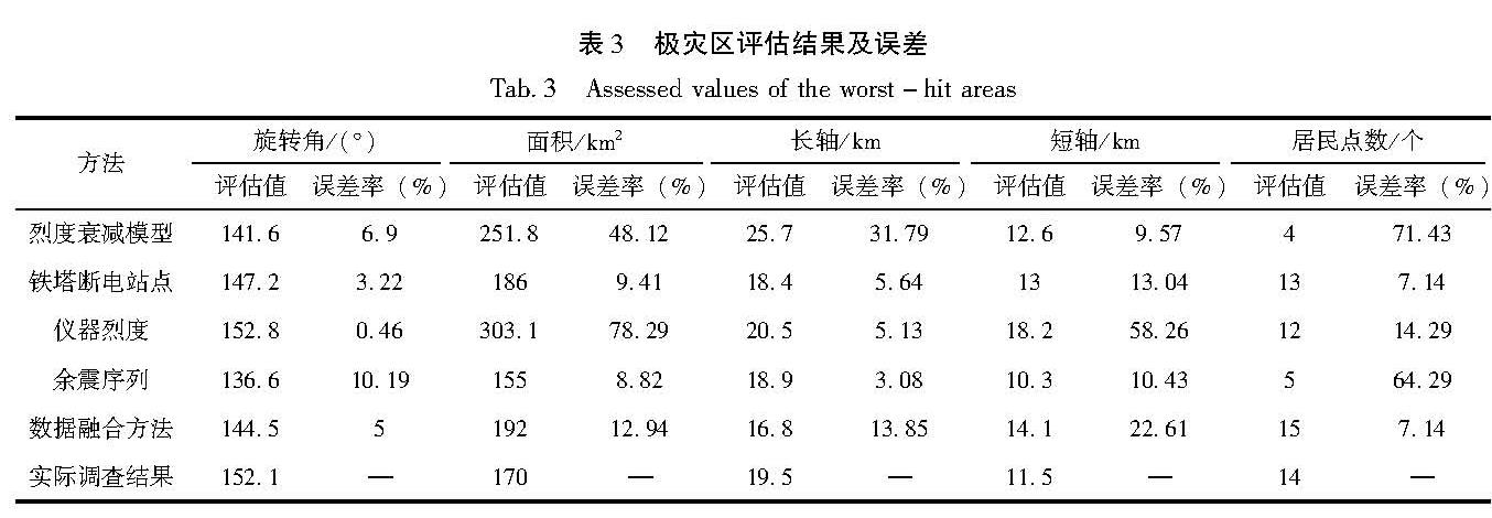
(1)根据烈度衰减模型计算,此次地震微观震中位于大理州漾濞县苍山西镇花椒园村,初判发震构造为维西—乔后断裂,影响场长轴方向为NW向,极灾区最高烈度为Ⅷ度,面积约为251.8 km2,覆盖了漾濞县白章村、花椒园村、秀岭村、太平乡4个居民点。
(2)根据仪器烈度统计,此次地震微观震中位于花椒园村,烈度区长轴方向NW向,向东靠近维西—乔后断裂,极灾区最高烈度为Ⅷ度,面积约303.1 km2,极灾区覆盖了白章村、花椒园村等12个居民点。
(3)从震后1 h余震序列空间分布看,余震主要分布在维西—乔后断裂西侧,沿着微观震中向ES方向单侧展布,余震区长度约25 km,宽度约5 km。根据拟合结果,极灾区面积155 km2,方向为NNW向,质心坐标位于微观震中东南向9.4 km处沙河村与秀岭村附近,极灾区覆盖了花椒园村、秀岭村、沙河村、仁民街社区、河西村5个居民点。
(4)此次地震造成铁塔基站断电站点一共有24处,主要分布在Ⅷ度区范围内,主要集中在微观震中东侧人口较为密集的县城和乡镇附近,沿紫阳村—淮安村—仁民街社区—河西村—石坪村一线呈NW向分布。根据拟合结果,极灾区面积186 km2,方向为NW向,质心坐标位于微观震中东侧9.8 km处的河西村附近,覆盖了秀岭村、白羊村、淮安村等13个居民点。
(5)根据上述有限集容斥原理和标准椭圆差方法,对烈度衰减模型、仪器烈度、余震序列、
图3 烈度衰减模型(a)、仪器烈度(b)、余震序列(c)、铁塔断电站点(d)、数据融合(e)和实际调查(f)极灾区范围
Fig.3 The worst-hit areas respectively determined according to the intensity attenuation model(a),the instrumental intensity(b),the aftershock sequence(c),the power-off transmission tower(d),the data fusion(e)and the field investigation(f)铁塔断电站点生成的4个极灾区居民点子集进行合并,生成多源数据融合后的地震极灾区。根据拟合结果,此次地震极灾区面积约144.5 km2,方向为NW向,质心坐标位于微观震中东侧约5.9 km的仁民街社区附近,极灾区覆盖了花椒园村、秀岭村等15个居民点。
3 讨论
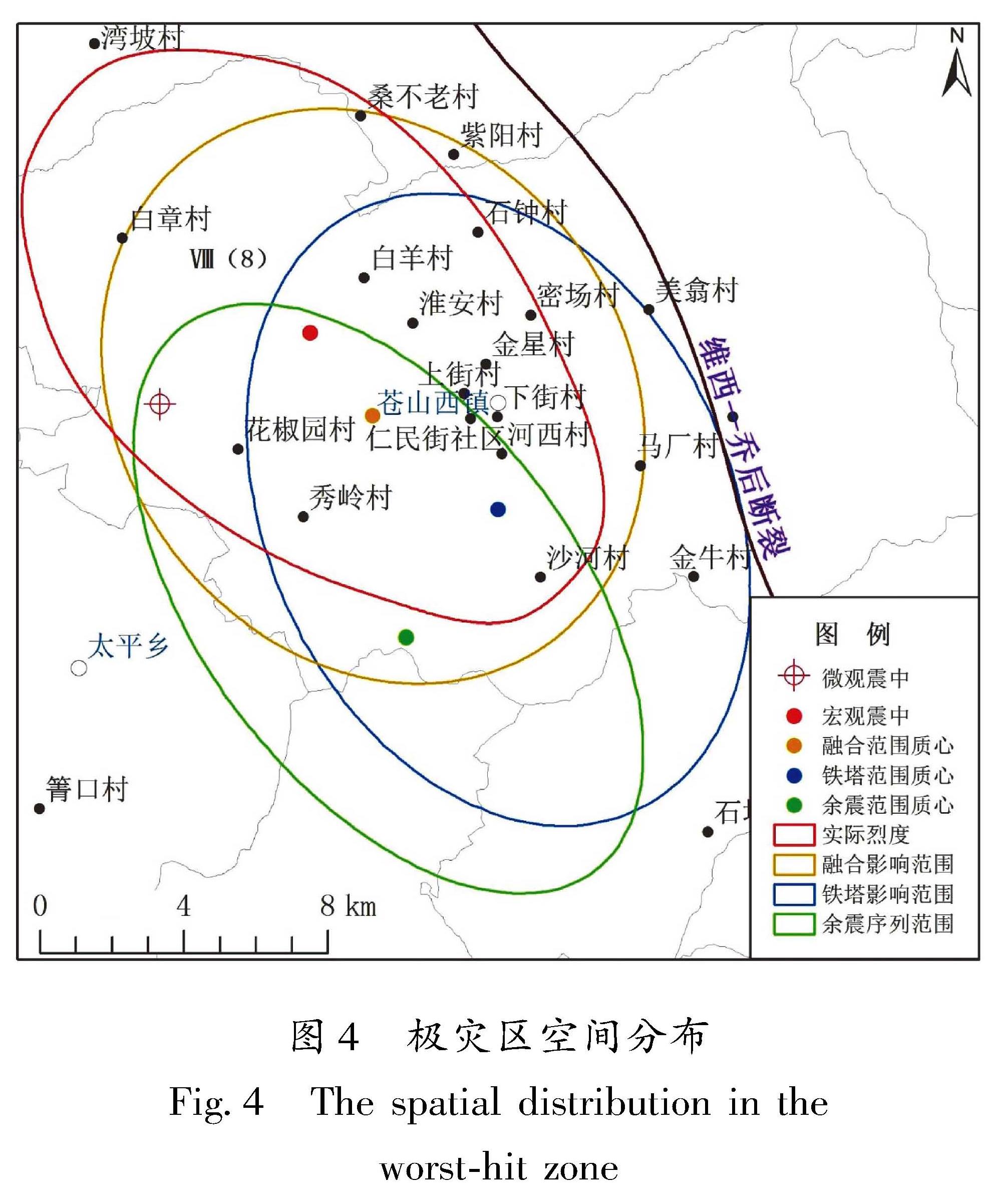
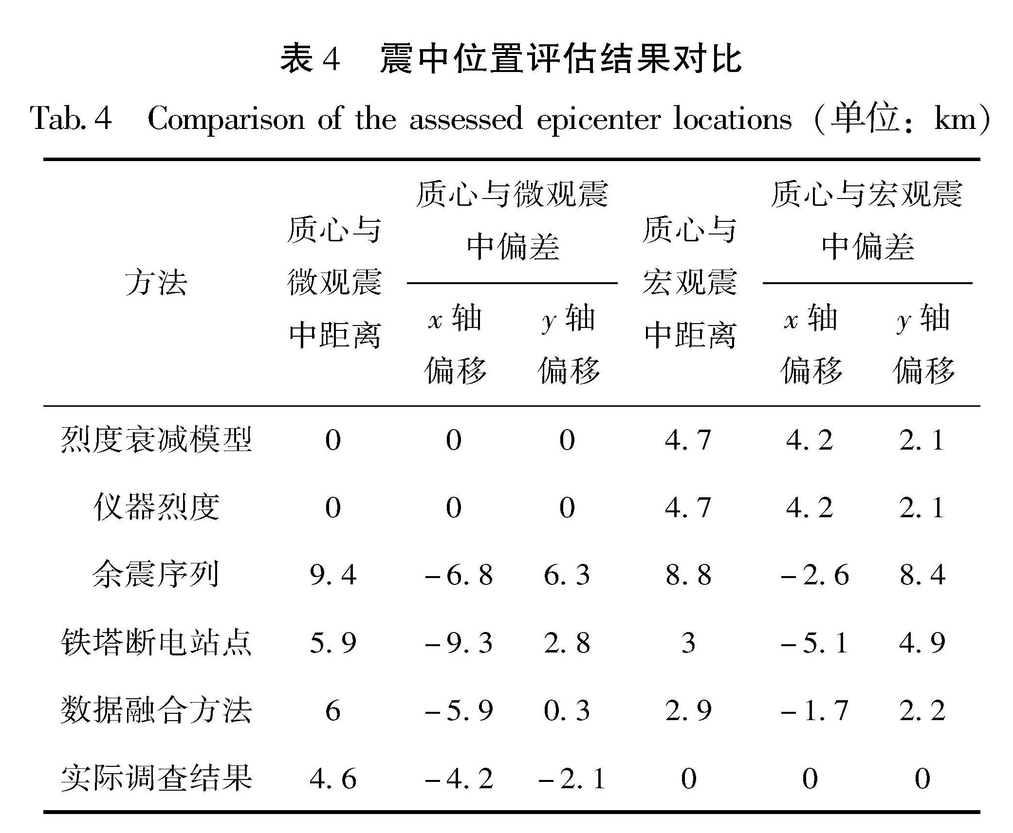
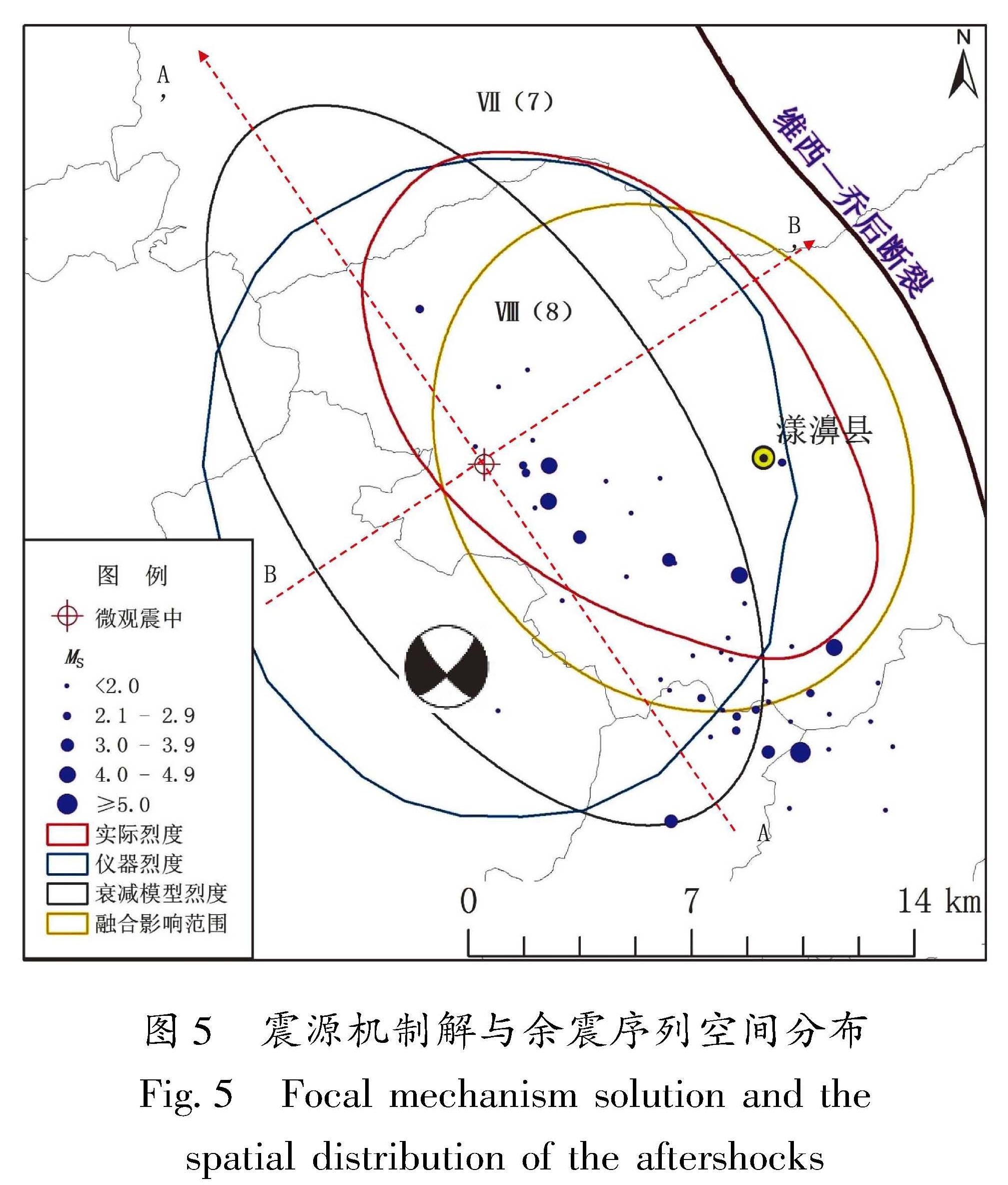
根据云南省地震局(2021)发布的漾濞MS6.4地震烈度图,地震最高烈度为Ⅷ度,地震发震构造为维西—乔后断裂,沿断裂西侧呈北NW展布。Ⅷ度区面积约170 km2,主要涉及漾濞县苍山西镇、漾江镇、太平乡3个乡镇。笔者采用平均绝对百分比误差(MAPE)对上述5种方法评估结果和实际调查评估结果进行对比,结果如图4、5,表3、4所示:
(1)从极灾区大小和空间分布对比分析看:极灾区范围最大评估值来自仪器烈度方法,面积为303.1 km2,约为实际面积2倍,误差率78.29%,其余方法拟合面积与实际相比误差率在10%左右。极灾区长轴拟合长度除烈度衰减模型方法外其余4种方法与实际结果相比误差率均小于15%,余震序列方法长轴与实际基本相符,极灾区短轴拟合长度与实际结果整体有一定偏差,烈度衰减模型方法拟合结果接近实际。从极灾区空间分布情况看,烈度衰减模型和仪器烈度拟合范围与实际位置相比向西侧偏移,约一半面积重合; 铁塔断电和余震序列方法所得结果则向南偏移,约三分之一面积重合。数据融合方法拟合的极灾区范围与实际范围重合面积142 km2,分别占各自面积的74%和84%,两者空间拟合分布基本一致。从极灾区影响的居民点数量和空间分布看,数据融合方法生成的极灾区覆盖居民点与实际较为接
近,该方法拟合的极灾区包含了15个居民点,实际调查结果包含14个居民点,两个区域重叠部分有13个居民点,吻合度达到了90%以上。
(2)从极灾区展布方向对比分析看:极灾区旋转角评估值最大的是仪器烈度方法,旋转角为152.8°,误差率仅为0.46%,与实际调查评估结果方向基本吻合; 评估值最小的是余震序列方法,旋转角为136.6°,误差率为10.19%。铁塔断电和数据融合方法方向与实际相比误差率小于5%,极灾区方向判定与实际结果基本一致。
(3)从极灾区质心坐标与微观、宏观震中对比分析可以看出:烈度衰减模型和仪器烈度方法所得极灾区质心坐标与微观震中位置一致,但从实际调查绘制的极灾区质心坐标来看,地震宏观震中与微观震中存在位置偏差,宏观震中位于微观震中EN方向约4.6 km的白羊村附近,x轴向西偏移4.2 km,y轴向北偏移2.1 km。而余震序列、铁塔断电、数据融合3种方法拟合的质心坐标都位于微观震中东侧,接近实际宏观震中位置。质心与宏观震中偏移量最小的是数据融合方法所得结果,x轴向西偏移1.7 km,y轴向南偏移2.2 km,位于淮安村和漾濞县城仁民街社区附近。
这5种方法拟合的极灾区大小方向、质心坐标等空间分布与实际结果存在一定的偏差,造成误差的主要原因如下:
(1)从极灾区大小和方向评估结果看(图6):利用烈度衰减模型方法生成极灾区误差的原因与衰减模型构建时历史震例样本数和采用回归方法密切相关,灾区活断层数据精度也会影响方向判定准确性。仪器烈度大小和方向与地震台网密度和插值方法密切相关,铁塔断电拟合范围和方向也与破坏站点的数量和空间分布相关。从云南台网震后1 h的余震序列空间分布和震源机制解结果看,节面I:走向139°/倾角76°/滑动角-165°,节面II:走向45°/倾角75°/滑动角-15°。离震中最近的主要活动断裂为NNW向维西—乔后断裂,余震序列呈NW向分布,呈现明显的NNW条带状,与断层节面I滑动方向一致。总体来说,在本次地震中,利用多源数据拟合后的极灾区大小和方向与实际调查评估绘制结果基本一致,能满足震后2 h灾情黑箱期快速评估需求。
(2)从极灾区宏观震中和微观震中偏移情况看(图5):这5种方法拟合所得的极灾区宏观震中与实际结果都存在不同程度的偏移。烈度衰减模型、仪器烈度、余震序列3种方法主要是考虑了地震震级、位置、余震、PGA、PGV等参数进行拟合,对区域内承灾体空间分布状况和震害破坏情况估计不足,导致与宏观调查烈度存在差异。对于云南地区来说,高原山地特征显著,地形地貌、地质构造、地震活动背景等孕灾环境多样复杂,社会经济、人口等承灾体时空分布差异性显著,多次震例表明,调查烈度、宏观震中往往与评估烈度、微观震中存在差异。从漾濞MS6.4实际震害
调查结果看,极灾区(Ⅷ度)宏观震中位置位于淮安村附近,灾区范围东起漾濞县苍山西镇河西村,西至苍山西镇大烂坝,南自苍山西镇沙河村,北达漾江镇弯坡村—桑不老村一带。在实际地震极灾区判定中,除了考虑地震本身物理参数外,还要融合地面多种承灾体实际破坏情况,极灾区判定才会更加精准。
4 结论
本文以2021年5月21日漾濞MS6.4地震为例,基于地震烈度衰减数学模型、仪器烈度、余震序列、铁塔基站断电等数据,利用标准椭圆差方程和容斥算法,通过多源数据拟合得出漾濞地震极灾区范围及空间分布。从5种拟合方法与实际结果的对比分析可以看出,基于多源数据融合的极灾区判定方法除了考虑地震本身物理参数外,还融合地表铁塔通信基站断电实际破坏情况,拟合得出的极灾区大小、方向、质心坐标等空间分布与实际灾害调查绘制结果基本一致,可为地震救援决策提供基础数据支撑。
由于云南地区孕灾环境和承灾体时空差异大,地震灾情多因子耦合关系复杂,无论哪一种极灾区判定方法都存在一定的局限性和适用范围,应结合物联网、互联网、人工智能等高新技术,快速获取灾情,接入动态实时的行业大数据,进一步提高地震极灾区研判精度。
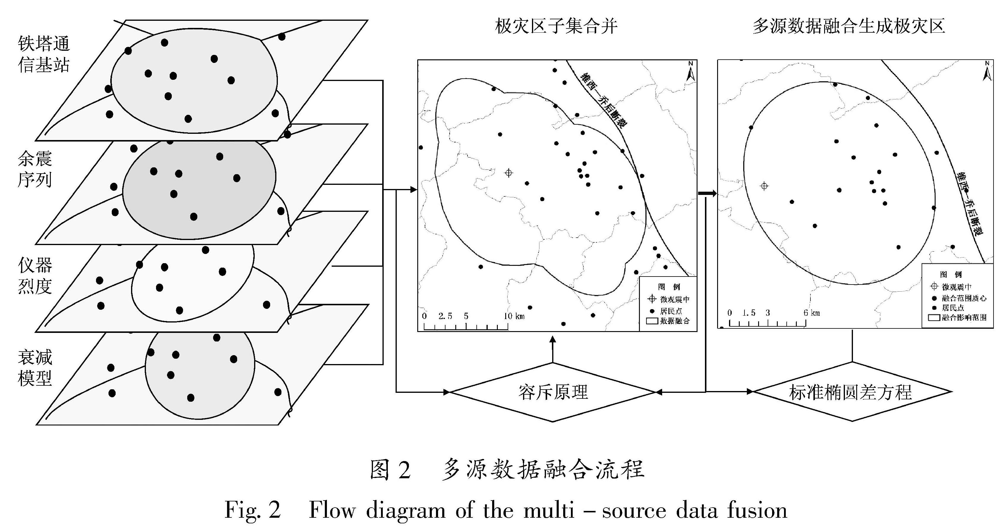
1.1 技术路线本文以云南地震应急基础数据库、余震序列数据、灾情数据等多源数据为基础,首先基于衰减模型、仪器烈度、余震序列、通信基站断电、多源数据融合5种方法生成地震极灾区子集,然后利用有限集容斥算法对每一个子集进行合并,提取融合范围内受影响的居民点数据集,采用标准椭圆差方程拟合生成极灾区。最后采用平均绝对百分比误差从极灾区大小、方向、宏观震中、空间位置分布状况等方面对这5种方法拟合结果与实际调查评估结果进行对比,分析产生误差的原因(图1)。
1.2 研究方法1.2.1 标准椭圆差算法本文采用标准椭圆差算法完成基于不同数据源的极灾区范围拟合。标准差椭圆算法是由美国南加州大学社会学教授韦尔蒂·利菲弗在1926年提出的度量地理空间分布的一种经典算法。该算法利用一系列离散数据点,通过坐标系变换的方法,使原坐标系中的离散数据点在新的坐标系下的标准差距离最小,从而反映点集的方向和分布趋势。该方法主要步骤如下:
(1)确定椭圆圆心。根据不同数据源,利用算数平均中心来计算椭圆的圆心,算法如下:
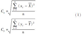
式中:Cx和Cy表示椭圆圆心x坐标和y坐标,xi和yi是单个点要素的空间位置坐标,
 是算数平均中心。
(2)确定椭圆方向性。根据不同数据源空间分布状况,以x轴为准,正北方(12点方向)为0度,顺时针旋转,算法如下:

式中:θ表示椭圆旋转角度;
 表示平均中心和x、y坐标的差。最后确定x、y轴的长度,算法如下:
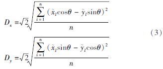
式中:Dx和Dy分别表示椭圆的x、y轴的长度。
(3)数据子集融合。利用有限集容斥原理对不同数据源生成的多个子集进行合并,提取影响区域居民点要素,把合并计数时重复计算数排斥出去,形成不同数据源融合范围内居民点要素集合,容斥算法如下:
设S为有限集,则:
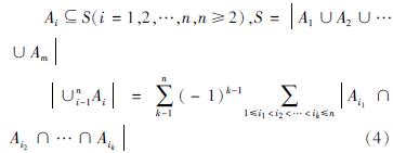
式中:S表示多个集合相并的有限集; Ai表示某一子集。
(4)生成极灾区。根据融合范围内的居民点集合,利用标准差椭圆方程拟合计算地震极灾区,确定极灾区空间分布和展布方向(图2)。
1.2.2 拟合结果精度校验采用平均绝对百分比误差方法对5种方法生成的地震极灾区评估值和真实值进行精度对比分析。计算数值越小,说明拟合算法精确度越好。具体算法如下:

式中:M表示表示平均绝对百分比误差; A表示真实值; F表示预测值。
-
白仙富,戴雨芡,李永强,等.2011.基于余震信息的宏观震中和影响场方向快速判定方法[J].地震研究,34(3):525-532.
- 薄涛,李小军,陈苏,等.2018.基于社交媒体数据的地震烈度快速评估方法[J].地震工程与工程振动,38(5):2016-215.
- 曹彦波,李永强.2018.云南地震应急关键技术与信息服务[M].昆明:云南科技出版社.
- 曹彦波,吴艳梅,许瑞杰,等.2017.基于微博舆情数据的震后有感范围提取研究[J].地震研究,40(2):303-310.
- 杜浩国,张方浩,邓树荣,等.2018.震后极灾区无人机最优航拍区域选择[J].地震研究,41(2):209-215.
- 段洪杰,杨黎薇,段然,等.2020.基于自主研发的软件框架在地震应用系统开发中的研究和应用[J].地震研究,43(1):195-205.
- 关曙渊,单振东,马荣.2020.日本仪器烈度计算 3 种方法对比[J].地震科学进展,50(8):20-24.
- 郭红梅,陈维锋,张莹,等.2015.多源地震灾情信息融合的烈度判定方法研究[J].华北地震科学,33(3):43-49.
- 郭建兴,张宇翔,姬建中,等.2020.利用居民地建筑物数据和高分遥感影像评估地震烈度的方法初探[J].地震地质,42(4):968-980.
- 郭志宇.2017.基于视频监控的震害快速评估与地震应急技术可行性研究[D].兰州:中国地震局兰州地震研究所.
- 胡素平,帅向华.2012.网络地震灾情信息智能处理模型与地震烈度判定方法研究[J].震灾防御技术,7(4):420-430.
- 李东平,陈海鹏,张凯,等.2019.基于社会视频监控信息源的地震影响范围快速勾画[J].地震研究,42(2):187-195.
- 李东平,刘倩倩,龚俊.2017.基于海量视频监控的中小地震烈度快速判断方法尝试[J].地震研究,40(2):324-332.
- 李金香,常想德,赵朔,等.2018.新疆塔什库尔干塔吉克自治县地震极灾区地震烈度遥感快速评估研究[J].中国地震,34(3):513-524.
- 李金香,赵朔,常想德.2020.基于无人机影像的皮山地震极灾区烈度评估[J].地震科学进展,50(3):20-24.
- 李山有,金星,陈先,等.2002.地震动强度与地震烈度速报研究[J].地震工程与工程振动,22(6):1-7.
- 李芋均,郭红梅,黄丁发,等.2020.基于区间证据理论的多源灾情信息融合及烈度判定研究[J].计算机应用研究,37(S2):92-94.
- 李兆隆,吴艳梅,李敏,等.2017.基于互联网信报控制协议的灾情信息获取技术研究与应用[J].地震研究,40(2):311-316.
- 梁永朵,姜金征,李莹,等.2015.几种烈度算法在实际震例中的对比研究[J].震灾防御技术,10(4):925-932.
- 聂高众,安基文,邓砚.2012.地震应急灾情服务进展[J].地震地质,34(4):783-789.
- 聂高众,徐敬海.2018.基于震源深度的极震区烈度评估模型[J].地震地质,40(3):611-621.
- 庞晓克.2019.基于手机位置信息的地震极震区位置与范围快速获取技术研究[D].北京:中国地震局地质研究所.
- 汪素云,俞言祥,高阿甲,等.2000.中国分区地震动衰减关系的确定[J].中国地震,16(2):99-106.
- 王德才,倪四道,李俊.2013.地震烈度快速评估研究现状与分析[J].地球物理学进展,28(4):1772-1784.
- 王伟锞,李志强,李晓莉.2011.利用余震法快速判定宏观震中的研究[J].震灾防御技术,6(1):36-48.
- 王晓青,窦爱霞,丁香,等.2015a.地震烈度应急遥感评估研究与应用进展[J].地球信息科学学报,17(12):1536-1544.
- 王晓青,窦爱霞,王龙,等.2015b.2013年四川芦山7.0级地震烈度遥感评估[J].地球物理学报,58(1):163-171.
- 吴艳梅,李兆隆,郑川,等.2019.云南省可定位IP地址数据特征及其在地震有感范围判定中的应用[J].华北地震科学,37(1):1-5.
- 徐敬海,褚俊秀,聂高众,等.2015.基于位置微博的地震灾情提取[J].白然灾害学报,24(5):12-18.
- 许建华,张雪华,王晓青,等.2017.无人机倾斜摄影技术在地震烈度评估中的应用-以九寨沟7.0级地震为例[J].中国地震,33(4):655-662.
- 杨天青,姜立新,董曼,等.2015.基于余震序列分布信息的地震极灾区快速判断方法研究[J].灾害学,30(1):8-15.
- 杨天青,席楠,张翼,等.2016.基于离散灾情信息的地震烈度分布快速判定方法研究[J].地震,36(2):48-59
- 岳汉,张勇,盖增喜,等.2020.大地震震源破裂模型:从快速响应到联合反演的技术进展及展望[J].中国科学:地球科学,50(4):515-537.
- 云南省地震局.2021.云南漾濞MS6.6地震烈度图发布[EB/OL].(2021-05-25)[2021-07-01].http://www.yndzj.gov.cn/yndzj/-300599/-300651/629959/index.html.
- 张方浩,蒋飞蕊,李永强,等.2016.云南地区地震烈度评估模型研究[J].中国地震,32(3):511-521.
- 张景发,李强,张庆云,等.2018.多源遥感图像的1976年MS7.8唐山大地震等烈度区判定[J].遥感学报,22(S1):162-173.
- 张苏平,孙艳萍,陈文凯.2013.余震信息在岷县漳县6.6级地震震后应急救援重灾区快速判定时作用讨论[J].地震工程学报,35(3):465-470.
- 张小咏,肖迪,苏中,等.2018.基于手机定位数据的地震灾害影响场方向模拟[J].系统仿真学报,30(11):4244-4248.
- 张勇,许力生,陈运泰.2013.芦山4·20地震破裂过程及其致灾特征初步分析[J].地球物理学报,56(4):1408-1411.
- 张勇,赵学志,肖爽.2018.基于通信大数据的地震影响初步判断[J].科技与创新,(20):43-44.
- 郑韵,姜立新,土辉山,等.2018.基于余震粒了群算法的极震区快速判定方法研究[J].地震,38(4):122-133.
- 郑韵,姜立新,杨天青,等.2015.利用余震频度分布进行宏观震中快速判定[J].地震,35(2):121-132.
- 周洋,明小娜,杨艳珠,等.2017.灾评新技术在云龙5.0级地震烈度调查中的应用[J].地震研究,40(1):161-166,168.
- Kodera Y,Yamada Y,Hirano k,et al.2018.The propagation of local Undamped Motion(PLUM)Method:A simple and robust wavefield estimation approach for earthquake early warning[J].Bulletin of the Seismological Society of America,108(2):983-1003
- Li D,Chen H,Shen W,et al.2021.An analysis of the temporal and spatial gathering and dispersion patterns of crowds at the community level after the 2020 M5.1 Tangshan Guye earthquake[J].International Journal of Disaster Risk Reduction,65,doi:org/10.1016/j.ijdrr.2021.102331.
- Wald D J,Vincent Q,Heaton T H,et al.1999.Relationships between peak ground acceleration,peak ground velocity,and modified intensity in California[J].Earthquake Spectra,15(3):557-564.

