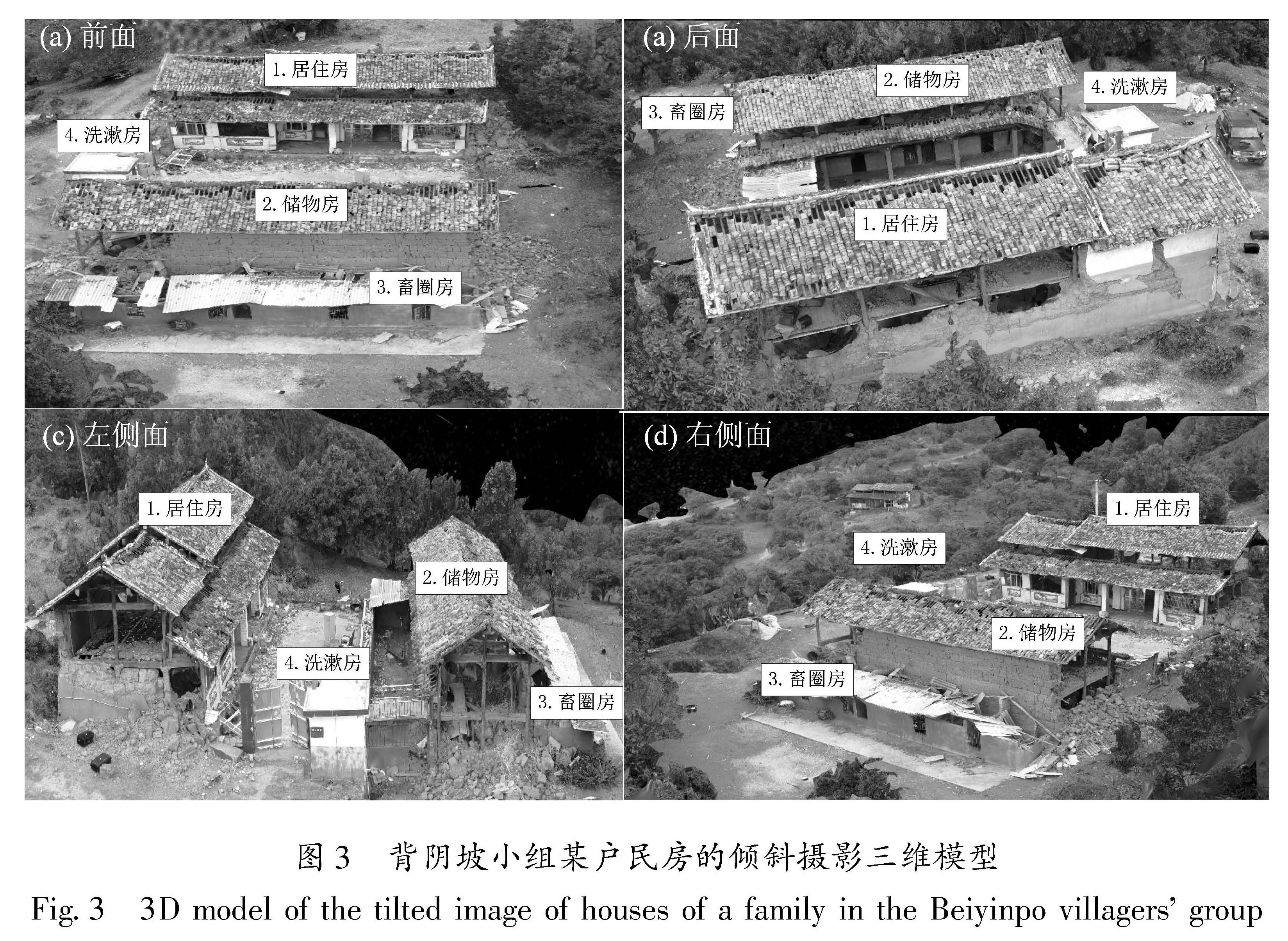
3.1 具体破坏情况
该民房顶部大面积梭瓦,人字形屋顶的顶部位置梭瓦最严重,几乎全部脱落,房屋四面墙体不同程度倒塌或开裂,各功能用房具体破坏情况如下:
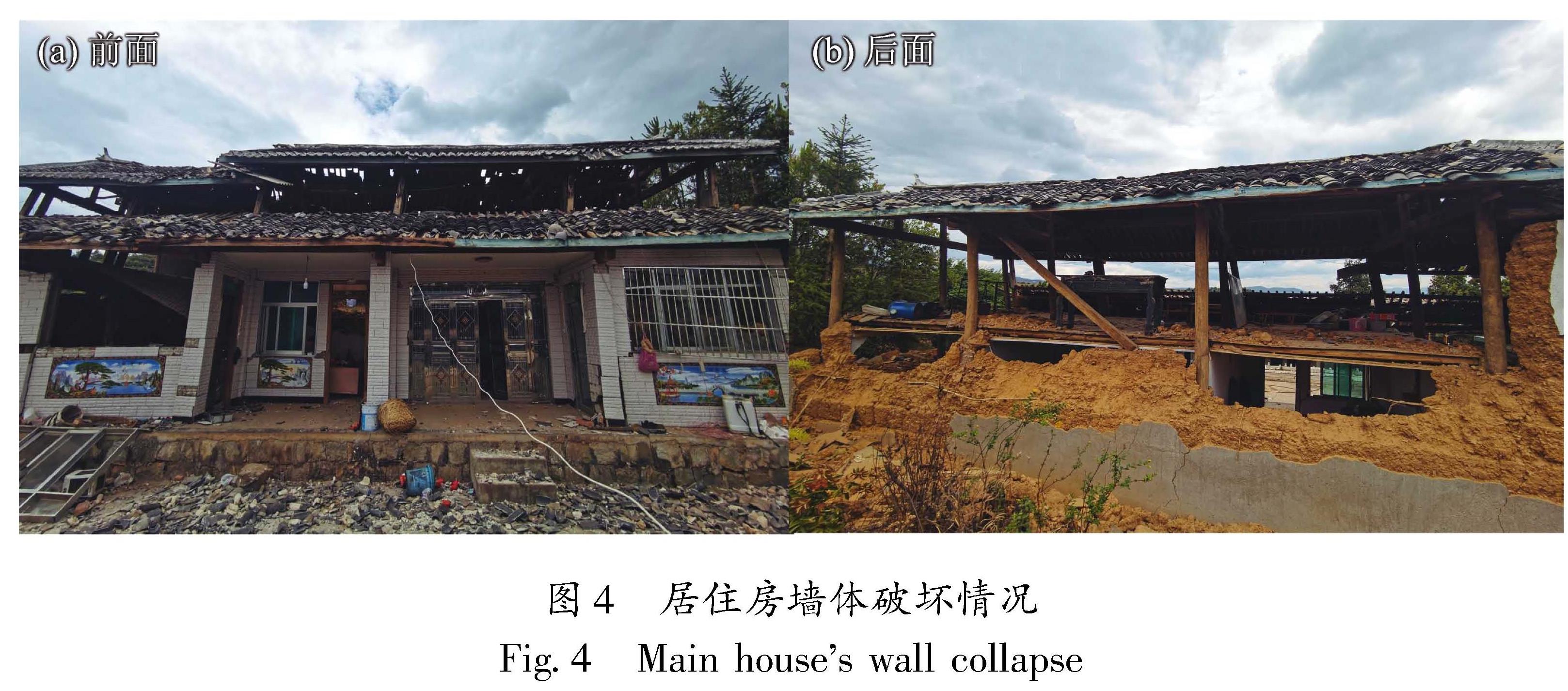
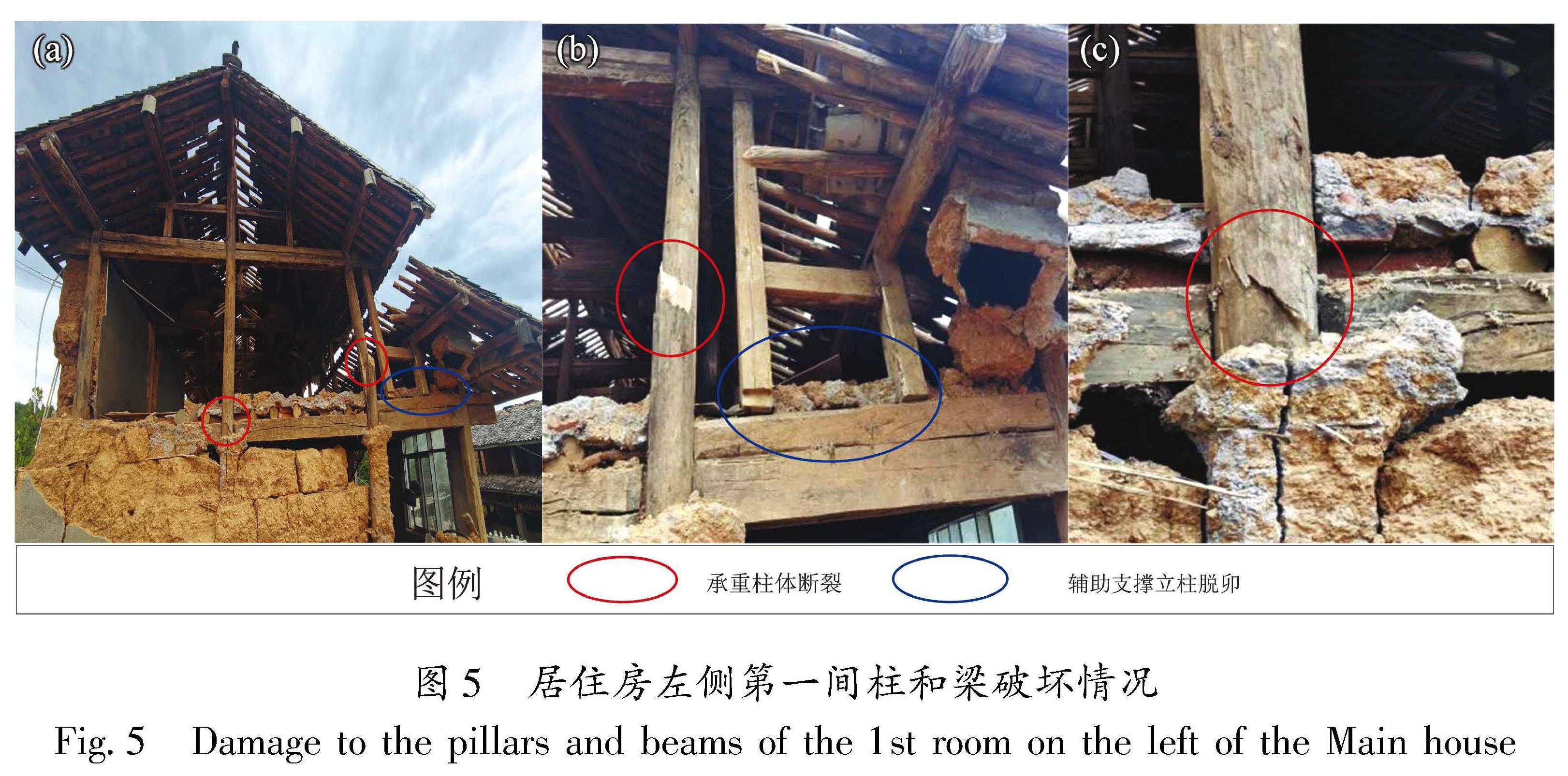
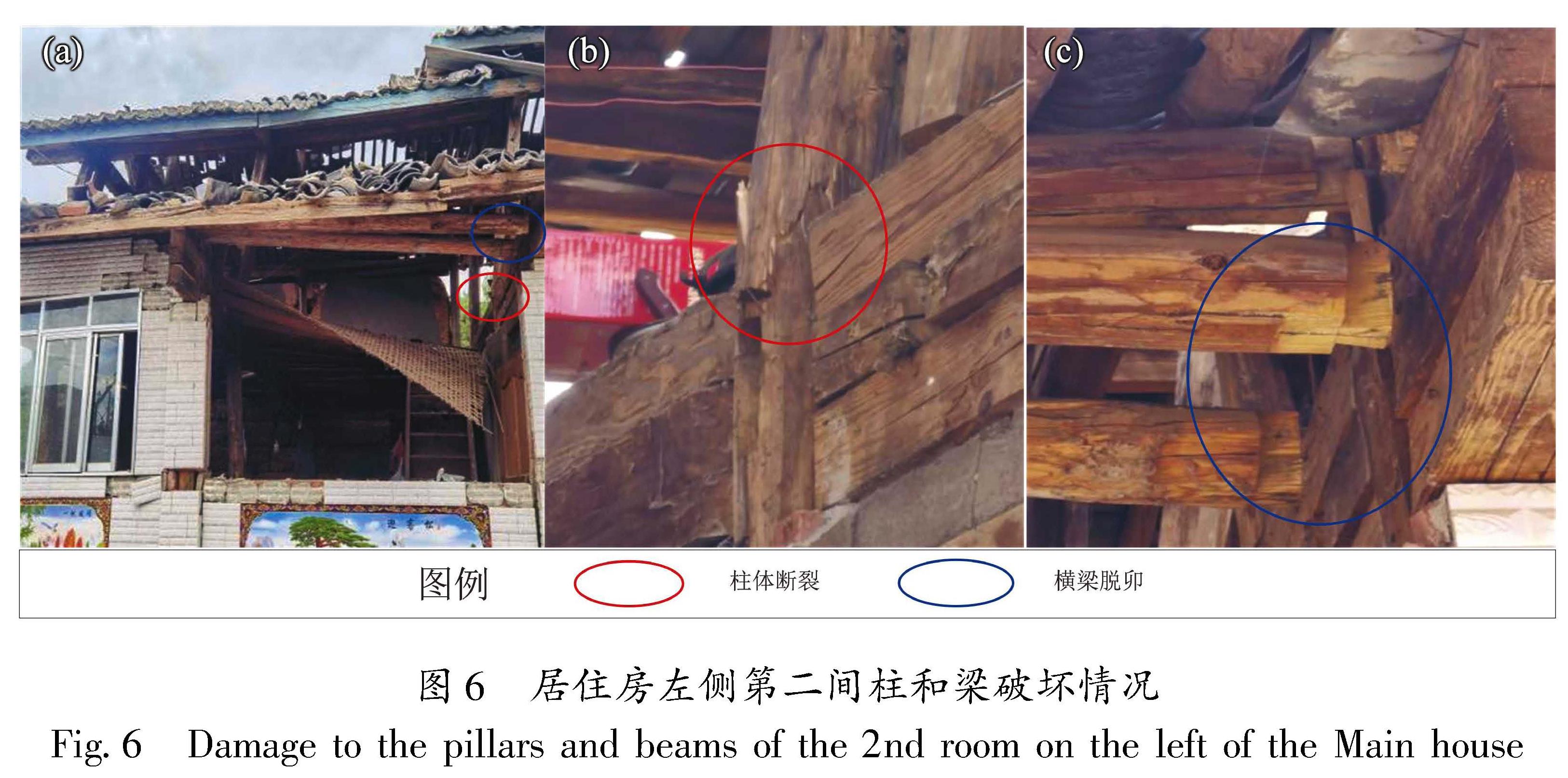
居住房是1995年建造的土木结构房屋(图4),两侧山墙和后墙是就地取材的夯土墙,在地震中两侧山墙和后墙的上半部分倒塌。前面墙体是砖墙,门窗较大,墙体相对较少,仅在门窗的两侧和下方有堆砌的砖墙。地震中由于砖墙与柱子和门窗震动不一致,导致砖墙体与柱子和门窗相分离,出现砖墙与柱子间的竖向裂缝以及与门窗之间的水平裂缝,铝合金窗体周围裂缝明显较大。门窗出现变形,铝合金窗体出现整体脱落或外凸的现象,室内大量家具和家电倒塌或掉落在地面上。在地震中居住房木架构受损严重,整体向右倾斜,左侧第一间的两根木柱断裂,2根辅助支撑立柱脱卯(图5); 左侧第二间有2根木柱断裂,4根横梁脱卯(图6)。其他房间柱子均有不同程度向右倾斜、弯曲、移位的现象,中间和顶部横梁有不同程度脱卯现象。对照《中国地震烈度表》(GB/T 17742—2020)土木结构房屋破坏现象表述,居住房达到了毁坏等级。
图4 居住房墙体破坏情况
Fig.4 Main house's wall collapse
图5 居住房左侧第一间柱和梁破坏情况
Fig.5 Damage to the pillars and beams of the 1st room on the left of the Main house
图6 居住房左侧第二间柱和梁破坏情况
Fig.6 Damage to the pillars and beams of the 2nd room on the left of the Main house
储物房是2007年建造的土木结构房屋(图7),地震后房顶大面积梭瓦,两侧夯土山墙倒塌,木结构整体向右轻微倾斜,未出现主要支撑立柱断裂的现象,但左侧第一间出现辅助支撑立柱榫子断裂、横梁垮塌的现象。
畜圈房是2020年建造的空心砖墙抬梁结构(图8a),这种结构抗震能力特别差,在地震中已彻底毁坏,墙体严重倒塌,引起上方横抬梁掉落,钉在横梁上的石棉瓦也随之掉落毁坏。
洗漱房是2021年建造的无圈梁构造柱砌体结构(图8b),四周是砖墙,顶上浇筑了一层钢筋混泥土,门窗一侧靠近大门钢筋混凝土立柱,地震中由于砖墙与大门立柱震动不一致导致墙体与立柱之间形成较大位移的错裂,门窗变形损坏。
图7 储物房破坏情况
Fig.7 Damage to the storeroom
图8 畜圈房(a)和洗漱房(b)破坏情况
Fig.8 Damage to the cattle enclosure(a)and laundry room(b)
3.2 破坏原因分析
由于云南地区复杂的地形地貌及场地条件,不同区域农村民居建筑具有显著的差异性,各类建筑结构抗震能力参差不齐(明小娜等,2017),在历次地震中都会出现一些破坏异常的点或区域。造成这种现象的主要原因是大震的近断层破坏(李小军等,2008)、局部地形或场地条件影响(包括山体放大效应、边坡效应、软土效应等)(王兰民,吴志坚,2013; 张建国等,2012)、房屋的抗震性能(包括建筑结构、材料、设计等存在缺陷)(张彦琪等,2017; 卢永坤等,2019)以及震害累加(施伟华等,2011)等因素。造成局部震害加重可能是某一个因素的主导,或者是某几个因素相互耦合的结果(迟明杰等,2014)。根据现场调查的情况,背阴坡小组某户民房地震后发生严重破坏的原因是多方面的,主要可能是由以下几个因素造成。
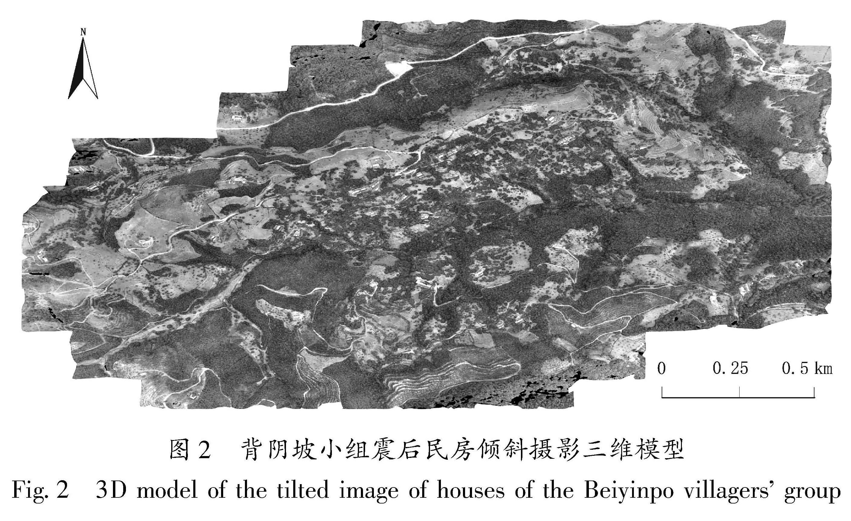
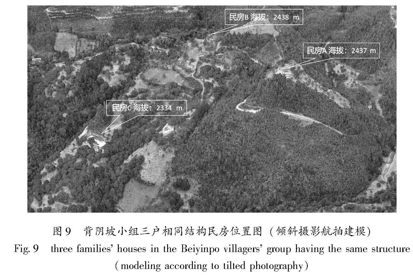
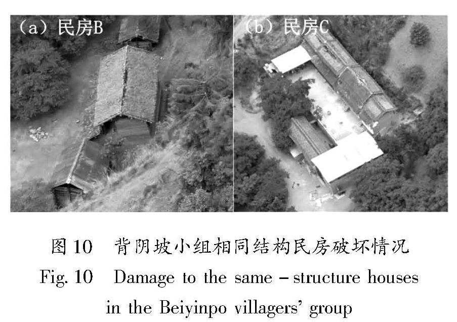
一是山体放大效应。在山区地貌条件下,震害的差异远大于平原区,地形高差和局部地貌条件(高山山梁及孤突山梁)对地震动的放大效应明显,直接影响到地震灾害程度的分布(孙崇绍等,2011)。背阴坡小组的民房都是依山而建,这是造成震害严重的重要原因,现场调查发现相对严重的民房震害与当地的场地条件有明显的对应关系。图9为背阴坡小组毁坏民房(民房A)与相同建盖时间、相同结构土木房屋(民房B和民房C)在倾斜摄影三维影像图中的位置,可以看出民房A位于山体上部的山脊,海拔高度2 437 m,民房B位于同一山体相近海拔高度的山洼,海拔高度2 438 m,民房C位于同一山体中部的山脊,海拔高度2 334 m,图 10为民房B和民房C的破坏。从不同海拔高度的相同结构的土木农居破坏程度可以看出,山体中部农居(民房C)房顶梭瓦,墙体轻微脱落而无倒塌,结构完好; 山体上部的农居(民房A)墙体大量倒塌,结构受损严重。从相同海拔高度的相同结构的土木农居破坏程度可以看出,位于山洼的农居(民房B)房顶梭瓦,墙体局部倒塌,结构完好; 而位于山脊的农居(民房A)毁坏。可见地震对房屋的影响呈现明显的沿山体自下向上的震害加重的趋势,山脊的震害明显重于山洼,表现出较明显的山体放大效应。
图9 背阴坡小组三户相同结构民房位置图(倾斜摄影航拍建模)
Fig.9 three families' houses in the Beiyinpo villagers' group having the same structure (modeling according to tilted photography)
图 10 背阴坡小组相同结构民房破坏情况
Fig.10 Damage to the same-structure houses in the Beiyinpo villagers' group
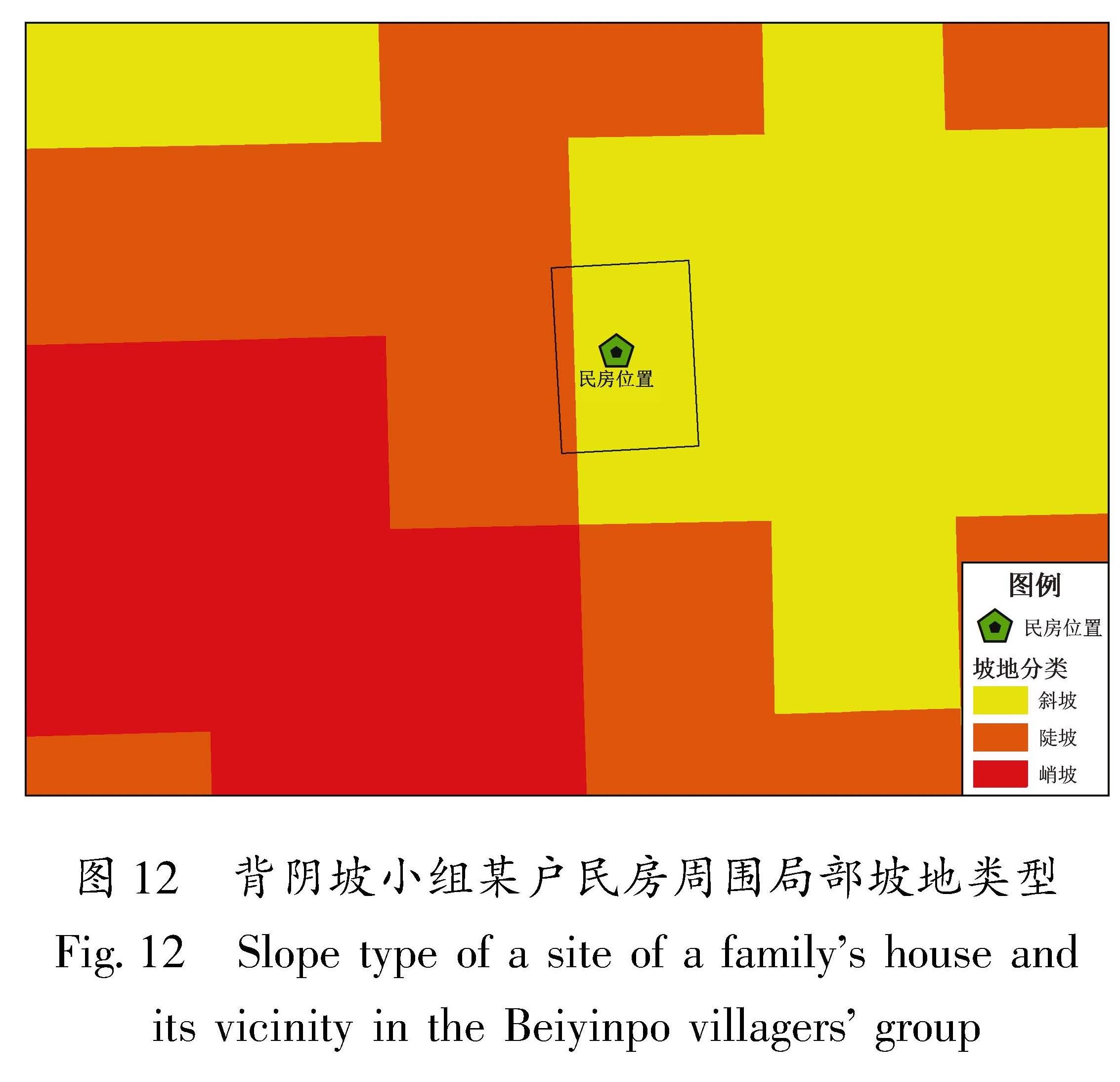
二是边坡的放大效应。从无人机影像产出的数字地表模型(DSM)上看(图 11),毁坏民房位于一个突出山梁的前缘顶部,其三面都是边坡,几乎凌空。为查看民房所在地三面坡体的坡度值,基于30 m×30 m网格DEM数据,将其转换格网内坡度值(图 12)。国际地理学联合会地貌调查与地貌制图委员会关于地貌详图应用的坡地分类为:0≤坡度≤0.5°为平原,0.5°<坡度≤2°为微斜坡,2°<坡度≤5°为缓斜坡,5°<坡度≤15°为斜坡,15°<坡度≤35°为陡坡,35°<坡度≤55°为峭坡,55°<坡度≤90°为垂直壁(曹彦波等,2014)。民房A所在的突出山体前面边坡的坡度值为15°~42°,属于陡坡和峭坡; 左面边坡的坡度值为18°~38°,属于陡坡和峭坡; 右面边坡的坡度值为7°~16°,属于斜坡和陡坡。位于山体前缘突脊的土木房屋倒塌(民房A),而在山体后部凹地的相同类型的房屋则局部倒塌(民房B)。从民房A三面
图 11 背阴坡数字地表模型(DSM)
Fig.11 Digital surface modeling(DSM) of the Beiyinpo villagers' group
图 11 背阴坡数字地表模型(DSM)
Fig.11 Digital surface modeling(DSM) of the Beiyinpo villagers' group
图 12 背阴坡小组某户民房周围局部坡地类型
Fig.12 Slope type of a site of a family's house and its vicinity in the Beiyinpo villagers' group
边坡都属于斜坡、陡坡和峭坡结合山体前缘和中后部位置相同结构房屋破坏的迥异现象来看,边坡效应导致的房屋震害加重现象显著。
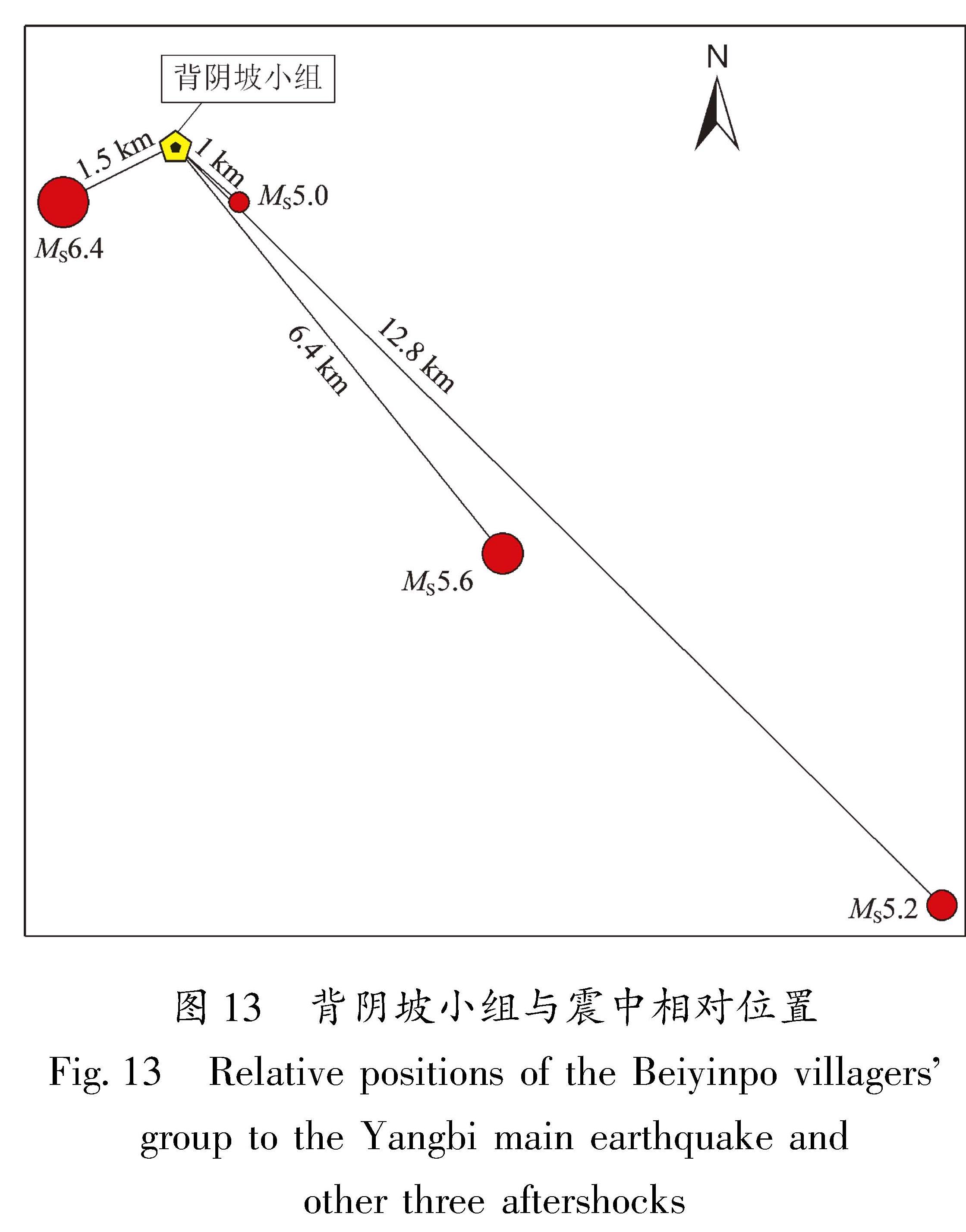
三是震害叠加效应。震害叠加效应在多次地震中都存在,本次地震中灾区在1 h左右时间内经历4次5级以上地震影响。从图 13可知背阴坡小组毁坏民居(民房A:99.882 9°E,25.676 6°N)位于MS6.4地震震中(苍山西镇秀岭村)东北方向1.5 km 、5.6级地震震中西北方向6.4 km、5.2级地震震中西北方向12.8 km、5.0级地震震中西北方向1 km处。背影坡小组与4次5.0级以上地震震中相距较近,造成了农居震害叠加,加重了灾情,但由于几次地震时间间隔短,较难获得现场的房屋破坏对比资料。
四是墙体的抗震能力弱。调查中发现,背阴坡小组的土木结构房屋墙体都是就地取材的夯土墙,制作夯土墙的土黏粒含量较低,砂石粗粒成份较高,降低了墙体黏结性,而且在建造过程中未加入茅草或稻草增强其黏性。在地震作用下夯土墙容易发生脆性破坏,抗剪、抗拉强度很低,导致墙体大面积垮塌。在建筑工艺上,夯筑时所用模板的不规则极易致使墙体中间缝隙过大,加之每层夯土的厚度很难保证适度合理,这些问题对夯土墙的质量也会产生影响(王兰民,吴志坚,2013)。